- Dewas District
-
This article is about the district. For its eponymous headquarters, see Dewas.
Dewas district
देवास ज़िला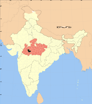
Location of Dewas district in Madhya PradeshState Madhya Pradesh,  India
IndiaAdministrative division Ujjain Headquarters Dewas Area 7,020 km2 (2,710 sq mi) Population 1,306,617 (2001) Lok Sabha Constituencies Dewas Official website Dewas District (Hindi: देवास ज़िला) is a district of Madhya Pradesh state in central India. The town of Dewas is the district headquarters.
The district has an area 7,020 km², and a population 1,306,617 (2001 census), an increase of 26% since 1991.
Dewas District roughly corresponds to the territories of the twin princely states of Dewas. The district straddles the Vindhya Range; the northern portion of the district lies on the Malwa plateau, while the southern portion lies in the valley of the Narmada River. The portion on the Malwa Plateau grows wheat, sorghum, rice, and cotton. The Narmada forms the southern boundary of the district. The district is bounded to the east by Sehore District, to the south by the Harda and Khandwa districts, to the west by the Khargone and Indore districts, and to the north by the Ujjain and Shajapur districts. Dewas District is part of Ujjain Division. Devsaal Rawats of Uttarakhand are said to have their origins in Dewas at the time of legendary king Vikramāditya.
Dewas District is now divided in to six tehsils namely Sonkatch, Dewas, Bagli, Kannod, Tonk-Khurd and Khategaon. Dewas tehsil is situated on the north-western part of the district, Sonkatch on the north-eastern part, Bagli on the south, Kannod on the south-central part and Khategaon on the South-east. Proper roadways connect all the tehsil head quarters. The head-quarters of Dewas tehsil, which is also the district headquarters, is situated on the Bombay-Agra National Highway No.3 and is also connected by broad-gauge railway line of western Railway.
Contents
Demographics
According to the 2011 census Dewas District has a population of 1,563,107,[1] roughly equal to the nation of Gabon[2] or the US state of Hawaii.[3] This gives it a ranking of 319th in India (out of a total of 640).[1] The district has a population density of 223 inhabitants per square kilometre (580 /sq mi) .[1] Its population growth rate over the decade 2001-2011 was 19.48 %.[1] Dewas has a sex ratio of 941 females for every 1000 males,[1] and a literacy rate of 70.53 %.[1]
Languages
Languages spoken include Bareli Rathwi, a Bhil language with approximately 64 000 speakers, written in the Devanagari script.[4]
References
- ^ a b c d e f "District Census 2011". Census2011.co.in. 2011. http://www.census2011.co.in/district.php. Retrieved 2011-09-30.
- ^ US Directorate of Intelligence. "Country Comparison:Population". https://www.cia.gov/library/publications/the-world-factbook/rankorder/2119rank.html. Retrieved 2011-10-01. "Gabon 1,576,665"
- ^ "2010 Resident Population Data". U. S. Census Bureau. http://2010.census.gov/2010census/data/apportionment-pop-text.php. Retrieved 2011-09-30. "Hawaii 1,360,301"
- ^ M. Paul Lewis, ed (2009). "Bareli, Rathwi: A language of India". Ethnologue: Languages of the World (16th edition ed.). Dallas, Texas: SIL International. http://www.ethnologue.com/show_language.asp?code=bgd. Retrieved 2011-09-28.
External links

Ujjain district Shajapur district Indore district 
Sehore district  Dewas district

West Nimar district East Nimar district Harda district Divisions & Districts of Madhya Pradesh · 
Bhopal Division: Chambal Division: Gwalior Division: Ashoknagar · Datia · Guna · Gwalior · Shivpuri
Indore Division: Jabalpur Division: Narmadapuram Division: Betul · Harda · Hoshangabad
Rewa Division: Sagar Division: Chhatarpur · Damoh · Panna · Sagar · Tikamgarh
Shahdol Division: Ujjain Division: Cities and towns in Ujjain Division Dewas district Mandsaur district Neemuch district Ratlam district Shajapur district Agar · Akodia · Badagoan · Badod · Kanad · Maksi · Polay Kalan · Shajapur · Shujalpur · Soyatkalan · SusnerUjjain district Related topics Cities and towns
in other DivisionsCategories:- Districts of Madhya Pradesh
- Dewas district
- Madhya Pradesh geography stubs

Wikimedia Foundation. 2010.