- Delaware Water Gap National Recreation Area
-
Delaware Water Gap National Recreation Area IUCN Category V (Protected Landscape/Seascape)
Location New Jersey & Pennsylvania, USA Nearest city Stroudsburg, Pennsylvania Coordinates 41°09′14″N 74°54′50″W / 41.15381°N 74.91388°WCoordinates: 41°09′14″N 74°54′50″W / 41.15381°N 74.91388°W Area 68,714 acres (27,808 ha) Established September 1, 1965 Visitors 5,052,264 (in 2005) Governing body National Park Service Delaware Water Gap National Recreation Area, administered by the National Park Service, preserves almost 70,000 acres (28,000 ha) of land along the Delaware River's New Jersey and Pennsylvania shores, stretching from the Delaware Water Gap northward almost to the New York state line. Middle Delaware National Scenic River is a designated 40-mile (64 km) section of the river entirely within the recreation area.
The park came about because of a plan to build a dam on the Delaware River at Tocks Island, just north of the Delaware Water Gap to control water levels for flood control and hydroelectric power generation. The dam would have created a 37 mile lake in the center of present park for use as a reservoir. Starting in 1960, the present day area of the Recreation Area was acquired for the Army Corps of Engineers through eminent domain. Between 3,000 and 5,000 dwellings were demolished, including historical sites, and about 15,000 people were displaced by the project. Because of massive environmental opposition, dwindling funds, and an unacceptable geological assessment of the dam's safety, the government transferred the property to the National Park Service in 1978. The National Park Service found itself as the caretaker of the previously endangered territory, and with the help of the federal government and surrounding communities, developed recreational facilities and worked to preserve the remaining historical structures.[1][2]
The recreation area runs from the northeastern outskirts of Milford, Pennsylvania (250 miles (400 km) above the Delaware's mouth into the Atlantic Ocean), roughly southwest to near Delaware Water Gap, Pennsylvania (approximately 210 miles (340 km) above the Delaware's mouth). It is located in parts of Sussex and Warren counties in New Jersey, and Monroe, Northampton, and Pike counties in Pennsylvania. The Appalachian Trail runs along much of the eastern boundary.
At the south end of the park, the river cuts eastward through the Appalachian Mountains at the scenic Delaware Water Gap. A one-day auto tour of the park can include waterfalls, rural scenery, and historic Millbrook Village. Visitors can also canoe, hike, camp, swim, picnic, bicycle, crosscountry ski, and horseback ride. Fishing and hunting are permitted in season with state licenses. The park hosts significant Native American archaeological sites, and a number of structures remain from early Dutch settlement during the colonial period.
Gallery
-

Raymondskill Falls
-

Silver Thread Falls
-

Dingman's Falls
-
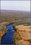
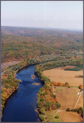
Middle Delaware River above Walpack Bend
-
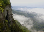
Cliffs above the Delaware River
References
- ^ Delaware Water Gap National Recreation Area (p. 7-8), Obiso, Laura, 2008.
- ^ Delaware Water Gap National Recreation Area, njskylands.com.
External links
- National Park Service: Delaware Water Gap National Recreation Area
- The Friends Of The Delaware Water Gap National Recreation Area
Protected Areas of Pennsylvania Federal Allegheny Portage Railroad • Edgar Allan Poe • Eisenhower • Friendship Hill • Gloria Dei (Old Swedes') Church • Grey Towers • Hopewell Furnace • Independence Hall • Steamtown • Valley ForgeAllegheny National Recreation Area • Delaware Water Gap National Recreation Area • Middle Delaware National Scenic River • Upper Delaware Scenic and Recreational RiverNational Wildlife Refuges:State Allegheny Islands • Archbald Pothole • Bald Eagle • Beltzville • Bendigo • Benjamin Rush • Big Pocono • Big Spring • Black Moshannon • Blue Knob • Boyd Big Tree • Buchanan's Birthplace • Bucktail • Caledonia • Canoe Creek • Chapman • Cherry Springs • Clear Creek • Codorus • Colonel Denning • Colton Point • Cook Forest • Cowans Gap • Delaware Canal • Denton Hill • Elk • Erie Bluffs • Evansburg • Fort Washington • Fowlers Hollow • Frances Slocum • French Creek • Gifford Pinchot • Gouldsboro • Greenwood Furnace • Hickory Run • Hillman • Hills Creek • Hyner Run • Hyner View • Jacobsburg • Jennings • Joseph E. Ibberson • Kettle Creek • Keystone • Kings Gap • Kinzua Bridge • Kooser • Lackawanna • Laurel Hill • Laurel Mountain • Laurel Ridge • Laurel Summit • Lehigh Gorge • Leonard Harrison • Linn Run • Little Buffalo • Little Pine • Locust Lake • Lyman Run • Marsh Creek • Maurice K. Goddard • McCalls Dam • McConnells Mill • Memorial Lake • Milton • Mont Alto • Moraine • Mt. Pisgah • Nescopeck • Neshaminy • Nockamixon • Nolde Forest • Norristown Farm • Ohiopyle • Oil Creek • Ole Bull • Parker Dam • Patterson • Penn-Roosevelt • Pine Grove Furnace • Poe Paddy • Poe Valley • Point • Presque Isle • Prince Gallitzin • Promised Land • Prompton • Prouty Place • Pymatuning • R. B. Winter • Raccoon Creek • Ralph Stover • Ravensburg • Reeds Gap • Ricketts Glen • Ridley Creek • Ryerson Station • S. B. Elliott • Salt Springs • Samuel S. Lewis • Sand Bridge • Shawnee • Shikellamy • Sinnemahoning • Sizerville • Susquehanna • Susquehannock • Swatara • Tobyhanna • Trough Creek • Tuscarora • Tyler • Upper Pine Bottom • Varden • Warriors Path • Whipple Dam • White Clay Creek • Worlds End • Yellow Creek
State ForestsBald Eagle • Buchanan • Clear Creek • Cornplanter • Delaware • Elk • Forbes • Gallitzin • Lackawanna • Loyalsock • Michaux • Moshannon • Rothrock • Sproul • Susquehannock • Tiadaghton • Tioga • Tuscarora • Weiser • William Penn • (Wild areas)
Bear Run • French Creek • Lehigh River • LeTort Spring Run • Lick Run • Lower Brandywine • Octoraro Creek • Pine Creek • Schuylkill River • Stony Creek • Tucquan Creek • Tulpehocken Creek • Yellow Breeches Creek
Other OtherAnders Run Natural Area • Forrest H. Duttlinger Natural Area • Hawk Mountain Sanctuary • Hoverter and Sholl Box Huckleberry Natural Area • Johnson Run Natural Area • Stone Valley Recreation Area • Wykoff Run Natural AreaHiking TrailsAppalachian • Baker • Black Forest • Central Mountains Shared Use Trails System • Darlington • Eastern Continental • Five Star • Glacier Ridge • Great Eastern • Greene River • Horse Shoe • Indian Creek Valley • Loyalsock • Mid State • Standing Stone • Mason-Dixon • North Country • Ohio River • Old Loggers Path • Pinchot Trail System • Potomac Heritage • Quehanna Trail System • Rachel Carson • Sheepskin • Susquehannock Trail System • Thunder Swamp Trail System • Tuscarora • Valley Forge Historical • West Rim • Wissahickon • Youghiogheny RiverAbandoned Pennsylvania Turnpike • Beaver River • East Coast Greenway • Five Star • Ghost Town • Great Allegheny Passage • Great Shamokin Path • Greene River • Indian Creek Valley • Lehigh Gorge • Liberty Bell • Lower • Montour • Ohio River • Palmer Bikeway • Panhandle • Perkiomen • Pine Creek • Plainfield Township • Schuylkill River • Sheepskin • Struble • Switchback • Three Rivers Heritage • York Country Heritage • Youghiogheny RiverNational Recreation Areas of the United States Administered by the
National Park ServiceAmistad • Big South Fork • Bighorn Canyon • Boston Harbor Islands • Chattahoochee River • Chickasaw • Curecanti • Delaware Water Gap • Gateway • Gauley River • Glen Canyon • Golden Gate • Lake Chelan • Lake Mead • Lake Meredith • Lake Roosevelt • Mississippi • Ross Lake • Santa Monica Mountains • Whiskeytown-Shasta-TrinityAdministered by
other agenciesAllegheny • Angel Peak • Arapaho • Datil Well • Flaming Gorge • Grand Island • Hells Canyon • Land Between The Lakes • Moosalamoo • Mount Baker • Mount Rogers • Oregon Dunes • Orilla Verde • Pine Ridge • Rattlesnake • Sawtooth • Smith River • Spring Mountains • Spruce Knob-Seneca Rocks • Valley of Fires • White Mountains • White Rocks • Wild Rivers • Winding Stair MountainNational Park Travelers Club Conventions 2003: Delaware Water Gap National Recreation Area • 2004: Rocky Mountain National Park • 2005: Mammoth Cave National Park • 2006: Sleeping Bear Dunes National Lakeshore • 2007: Olympic National Park • 2008: Lowell National Historical Park • 2009: Sequoia National Park • 2010: El Malpais National Monument • 2011: National Mall • 2012 (planned): Apostle Islands National LakeshoreCategories:- IUCN Category V
- United States National Park Service National Recreation Areas
- United States National Park Service Wild and Scenic Rivers
- Wild and Scenic Rivers of the United States
- The Poconos
- Delaware Water Gap
- United States National Park Service areas in New Jersey
- United States National Park Service areas in Pennsylvania
- Protected areas on the Appalachian Trail
- Protected areas of Sussex County, New Jersey
- Protected areas of Warren County, New Jersey
- Protected areas of Northampton County, Pennsylvania
- Protected areas of Monroe County, Pennsylvania
- Protected areas of Pike County, Pennsylvania
-


Wikimedia Foundation. 2010.