- Mare Crisium
-
For other uses, see Mare Crisium (disambiguation).
Mare Crisium 
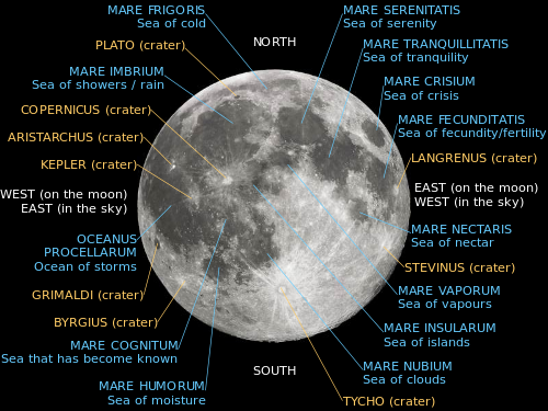
Mare CrisiumCoordinates 17°00′N 59°06′E / 17.0°N 59.1°ECoordinates: 17°00′N 59°06′E / 17.0°N 59.1°E Diameter 555 km (345 mi)[1] Eponym Sea of Crises Mare Crisium (the "Sea of Crises") is a lunar mare located in the Moon's Crisium basin, just northeast of Mare Tranquillitatis. This basin is of the Pre-Imbrian period, 4.55 to 3.85 billion years ago. This mare is 555 km (345 mi) in diameter,[1] and 176,000 km2 in area. It has a very flat floor, with a ring of wrinkled ridges toward its outer boundaries. Ghost craters, craters that have largely been buried under deposits of other material, are located to the south.[2]
A soil sample from Mare Crisium was successfully brought to Earth on 22 August 1976 by the Soviet lunar mission Luna 24.
The crater has many notable features in and around it. The cape-like feature protruding into the southeast of the mare is Promontorium Agarum. On the western rim of the mare is the palimpsest Yerkes. The crater Picard is located just to the east of Yerkes, and northwest of Picard is the crater Peirce. Mare Anguis can be seen northeast of Mare Crisium.[3] Mare Crisium is the site of the Luna 15 crash in 1969.
In Robert A. Heinlein's novel The Moon is a Harsh Mistress Mare Crisium is the site of a Lunar Colony, named Luna City.
References
- ^ a b "Moon Mare/Maria". Gazetteer of Planetary Nomenclature. USGS Astrogeology. http://planetarynames.wr.usgs.gov/SearchResults?target=MOON&featureType=Mare%2C%20maria. Retrieved 2010-08-20.
- ^ Autostar Suite Astronomer Edition. CD-ROM. Meade, April 2006.
- ^ "Mare Crisium". lunar.arc.nasa.gov. http://lunar.arc.nasa.gov/science/atlas/mare/mcrisium.htm. Retrieved October 18, 2007.
Lunar maria Mare Oceanus Lacus Sinus Paludes Categories:- LQ13 quadrangle
- Maria on the Moon
- Moon stubs


Wikimedia Foundation. 2010.