- County Borough of East Ham
-
East Ham Motto: Progressio cum Populo (Progress with the people) 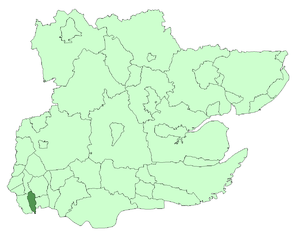
East Ham within Essex in 1961Geography Status Local Government District (1878 - 1894)
Urban district (1894 - 1904)
Municipal borough (1904-1915)
County borough (after 1915)1894 area 3,324 acres (13.5 km2) 1965 area 3,324 acres (13.5 km2) HQ East Ham History Created 1894 Abolished 1965 Succeeded by London Borough of Newham Demography 1901 population 96,008 1961 population 105,682 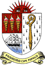
East Ham was a local government district in the far south west of Essex from 1878 to 1965. It extended from Wanstead Flats in the north to the River Thames in the south and from Green Street in the west to Barking Creek in the east. It was part of the London postal district and Metropolitan Police District.
Contents
Local board and urban district
East Ham Local Government District was created in 1878, when the parish of East Ham adopted the Local Government Act 1858, and formed a local board of nine members to govern the area. In 1886 the local government district was extended to include the civil parish of Little Ilford, and the board was increased to 12 in number. The Local Government Act 1894 reconstituted the area as an urban district, with an elected urban district council of 15 members replacing the board. In 1900 Little Ilford parish was abolished and its area absorbed into an enlarged East Ham.
Incorporation
On 27 August 1904 East Ham was granted a charter of incorporation constituting the town as a municipal borough.[1] A new town council consisting of a mayor, six aldermen and eighteen councillors replaced the urban district council.[2] The four wards of the urban district were replaced by six new wards (Beckton & North Woolwich, Central East, Central West, Manor Park, Plashet East, Plashet West), each returning three councillors and one aldermen.[1]
County borough
In 1915 the borough gained independence from county administration as a county borough, against the objections of Essex County Council.[3] The size of the borough council was increased to ten alderman and thirty councillors in 1920, representing ten wards: Castle, Central, Greatfield, Kensington, Little Ilford, Manor Park, Plashet, South, Wall End and Woodgrange.[2][4]
Boundaries
The borough included most of the current-day London Borough of Newham east of Green Street including Little Ilford, Manor Park, East Ham and Beckton. It excluded North Woolwich, as historically this was part of the Metropolitan Borough of Woolwich, in the County of London. The borough ran its own tram services until they became the responsibility of the London Passenger Transport Board in 1933.[5] The borough ran its own fire brigade which was absorbed into the London Fire Brigade in 1965. East Ham's Town Hall now serves as Newham Town Hall.
Coat of arms
The borough did not have an official coat of arms, but used a device designed by the surveyor to the urban district council in 1896.[6] In a 1916 book on the arms of Essex boroughs the "pseudo-heraldic device" was dismissed as "a somewhat obvious imitation of the arms of West Ham".[7] The official explanation of the device was that the crosier stood for Stratford Langthorne Abbey, established by William de Montfichet in the 12th century; the burning torches stood for the Beckton gasworks; the sailing ship for the docks and the rising sun for "the ascending of East Ham, which within a few years developed with such marvellous rapidity."[6]
Politics
In common with most boroughs, early elections were officially non-political and were often uncontested. In 1906 a Labour Representation Committee was formed in East Ham, and it affiliated with the national Labour Party in 1908.[4] In response, and in imitation of the highly successful London Municipal Reform Party, the local Conservative and Liberal organisations formed an anti-Labour Municipal Alliance.[8]
The Alliance, which also embraced independent and ratepayer candidates, secured a large majority at the municipal elections of 1907, with Labour forming the opposition on the council.[9]
In 1928 the elections produced a hung council, with Labour and the Municipal Alliance each having 20 members. In the following year a single gain saw Labour take control, which they were to retain for the remainder of the borough's existence.[10] The defeated opposition group stood as "Anti-Labour" from the next elections in 1929 and were retitled as the Civic Party in 1933.[4]
When local elections were resumed after the Second World War, Labour faced official Conservative candidates for the first time.[11] Conservatives formed a small opposition group, later supplanted by Independents. After the final municipal elections in 1963, Labour held 30 seats and Independents 10.[12]
Abolition
The county borough, along with the County Borough of West Ham, was abolished and became part of the London Borough of Newham in 1965 when Greater London was created. Although the County Borough was administratively independent from Essex, it did form part of the county, and so like the other Essex authorities incorporated into Greater London, the majority of its public records up to 1965 are held in the Essex County Record Office in Chelmsford. Discussions are continuing between county and London Borough archivists which may lead to the return of records to their originating districts.
Demographics
Population of East Ham from 1801 to 1911
Year[13] 1801 1851 1861 1881 1891 1901 1911 Population <2000 <2000 2,858 10,706 32,713 96,018 133,487 Dwellings n/a n/a 497 1,930 5,818 17,937 25,694 Gallery
-

East Ham Town Hall
-

Entrance to town hall. Note the EH around the doorway for East Ham.
References
- ^ a b "The Incorporation of East Ham". The Times: p. 6. 15 September 1904.
- ^ a b East Ham: Local government and public services, A History of the County of Essex: Volume 6 (1973), pp. 18-24, (British History Online), accessed February 6, 2008
- ^ New London County Borough, The Times, March 13, 1914
- ^ a b c County Borough Elections in England and Wales, 1919-1938: Chester-East Ham. Volume 3 of County Borough Elections in England and Wales, 1919-1938: A Comparative Analysis. Aldershot: Ashgate. 2006. pp. 565–636. ISBN 1840142618.
- ^ Reed, J., London Tramways, (1997)
- ^ a b Scott-Giles, C Wilfrid (1953). Civic Heraldry of England and Wales, 2nd edition. London: J M Dent & Sons. p. 125.
- ^ Benham, W Gurney (1916). Essex Borough Arms and the Traditional Arms of Essex and the Arms of Chelmsford Diocese. Colchester: Benham & Company. p. 62.
- ^ "Conference On Socialism". The Times: p. 9. 25 October 1907.
- ^ "The Municipal Elections". The Times: p. 6. 2 November 1907.
- ^ "The Municipal Elections". The Times: p. 14. 2 November 1929.
- ^ "The Municipal Elections". The Times: p. 2. 3 November 1945.
- ^ "Election Results in the Boroughs". The Times: p. 10. 10 May 1963.
- ^ Alfred Stokes East Ham from village to County Borough
- Local Government Act 1894
- London Government Act 1963
External links
Local government districts abolished or transferred by the London Government Act 1963 London · CC Battersea · Bermondsey · Bethnal Green · Camberwell · Chelsea · Deptford · Finsbury · Fulham · Greenwich · Hackney · Hammersmith · Hampstead · Holborn · Islington · Kensington · Lambeth · Lewisham · Paddington · Poplar · Shoreditch · Southwark · St. Marylebone · St. Pancras · Stepney · Stoke Newington · Wandsworth · Westminster · Woolwich
Constituent parts of Greater LondonEssex Barking · Chigwell (part) · Chingford · Dagenham · East Ham · Hornchurch · Ilford · Leyton · Romford · Walthamstow · Wanstead and Woodford · West Ham
Hertfordshire Middlesex · CC Acton · Brentford and Chiswick · Ealing · Edmonton · Enfield · Feltham · Finchley · Friern Barnet · Harrow · Hayes and Harlington · Hendon · Heston and Isleworth · Hornsey · Ruislip-Northwood · Southall · Southgate · Tottenham · Twickenham · Uxbridge · Wembley · Willesden · Wood Green · Yiewsley and West Drayton
Kent Surrey Transfers Categories:- Districts of England created by the Local Government Act 1894
- Districts abolished by the London Government Act 1963
- History of local government in London (1889–1965)
- History of Newham
- Local Government Districts created by the Local Government Act 1858
- County boroughs of England
-


Wikimedia Foundation. 2010.