- 2003 Pacific typhoon season
Infobox hurricane season
Basin=WPac
Year=2003
Track=2003 Pacific typhoon season summary.jpg
First storm formed=January 18 ,2003
Last storm dissipated=December 2 ,2003
Strongest storm name=Maemi
Strongest storm winds=105
Strongest storm pressure=910
Average wind speed=10
Total Depressions=21 official, 10 unofficial
Total storms=21 official, 3 unofficial
Total hurricanes=14
Total intense=5 (unofficial)
Fatalities=264
five seasons=2001, 2002, 2003, 2004, 2005|}The 2003 Pacific typhoon season has no official bounds; it ran year-round in 2003, but mosttropical cyclones tend to form in the northwesternPacific Ocean between May and November http://www.typhoon2000.ph/garyp_mgtcs/may03sum.txt] . These dates conventionally delimit the period of each year when most tropical cyclones form in the northwesternPacific Ocean .The scope of this article is limited to the Pacific Ocean, north of the equator and west of the
international date line . Storms that form east of the date line and north of the equator are called hurricanes; see2003 Pacific hurricane season . Tropical Storms formed in the entire west Pacific basin are assigned a name by the Tokyo Typhoon Center. Tropical depressions in this basin have the "W" suffix added to their number. Tropical depressions that enter or form in the Philippine area of responsibility are assigned a name by thePhilippine Atmospheric, Geophysical and Astronomical Services Administration or PAGASA. This can often result in the same storm having two names.torms
In storm information below, wind-speed advisories differ from the
Joint Typhoon Warning Center (JTWC) to the JMA as the JTWC uses theUnited States criteria of 1-minute mean to designate maximum sustained winds, while the JMA uses the 10-minute mean wind criteria to designate tropical cyclone maximum sustained winds. This difference generally results in JTWC maximum winds appearing higher than the maximum winds described by the JMA for the same cyclone.Tropical Storm Yanyan
Infobox Hurricane Small
Basin=WPac
Formed=January 18
Dissipated=January 20
10-min winds=35
1-min winds=50
Pressure=1000Yanyan is a fairly common pet name for young girls in Hong Kong. Every other year since 1990, a tropical depression has formed in this basin in January, and 2003 was the second year in a row a tropical storm formed during January in the Northwest Pacific. The pre-Yanyan disturbance was first noted atJanuary 11 near the International Dateline just north of the equator. On the 13th, a tropical depression formed from this convection near 2.4N 173.8E. It moved west-northwest at convert|18|mi/h|km/h|abbr=on, moving convert|170|mi|km north-northeast of Chuuk by the 17th. Tropical storm status was reached on the 18th while northeast of Guam. It soon recurved northward, reaching its peak intensity of 50 kts/60 mph on the 19th convert|140|mi|km east-southeast of Saipan. Yanyan moved more northeasterly by late on the 18th, and weakened to a tropical depression on the 20th. The system dissipated on the 21st near 19.0N 158.0E. [http://www.typhoon2000.ph/garyp_mgtcs/jan03sum.txt]Typhoon Kujira (Amang)
Infobox Hurricane Small
Basin=WPac
Track=Kujira 2003 track.pngApril 11
Dissipated=April 25
10-min winds=90
1-min winds=135
Pressure=930An area of convection developed on
April 7 UTC convert|400|mi|km southeast of Chuuk. It developed into a Tropical Depression 02W by the 9th about convert|230|mi|km south-southeast of Pohnpei while drifting north. Tropical storm status was achieved on the 11th as it moved convert|100|mi|km past Pohnpei, and the track shifted towards the west. The cyclone passed convert|200|mi|km north of Chuuk on the 12th. By the 14th, Kujira strengthened into a typhoon status about convert|230|mi|km southeast of Guam. The intensifying typhoon moved west-northwest, and Kujira was the year's first super typhoon by the 16th. Its peak intensity of 135 kts/155 mph was reached about convert|215|mi|km north-northwest of Yap. Late on the 16th, the typhoon crossed 135E and gained the name Amang. By the 17th, the typhoon interacted briefly with a frontal zone before resuming a more westward track. On the 21st, Kujira was tracking northwestward at convert|7|mi/h|km/h|abbr=on towards Taiwan/Taipei and weakening and was downgraded to a tropical storm. Movement became erratic on the 23rd while approaching the mountainous island. After passing convert|190|mi|km south-southeast of Taipei, its forward motion increased to the north-northeast to convert|43|mi/h|km/h|abbr=on by late on the 25th as Kujira made landfall on the Japanese island of Kyūshū near Ushibuka, quickly becoming a nontropical low. Long-lived Kujira was thirteen advisories short of the longest-lived Western Pacific tropical cyclone on record, Typhoon Rita of 1972, and three shy of Typhoon Opal (1967).Lan Yu, Taiwan experienced gale-force winds from
April 22 -24. The pressure there fell to 965.0 mb on the 23rd as winds peaked at 62.2 kts/72 mph. Okinawa measured 342 mm of rainfall onApril 24 . Ishigakijima, Okinawa recorded a lowest pressure of 996.9 hPa late on the 24th, and the highest gust in all of Japan of 76.2 kts/88 mph. Kujira was the first named April tropical cyclone of the past 25 years to affect Taiwan and was Japan's earliest tropical cyclone landfall on record. The typhoon caused 2 deaths inPohnpei , but only minor damage. [http://www.typhoon2000.ph/garyp_mgtcs/apr03sum.txt]Typhoon Chan-Hom
Infobox Hurricane Small
Basin=WPac
Track=Chan-Hom 2003 track.pngMay 20
Dissipated=May 27
10-min winds=85
1-min winds=115
Pressure=940May 18 , a tropical disturbance was being watched convert|300|mi|km southwest of Chuuk. A tropical depression formed from the area by the 19th about convert|500|mi|km southeast of Guam. A reconnaissance plane investigating the depression indicated tropical storm strength had been achieved as it moved convert|100|mi|km west of Chuuk; it took an additional 30 hours for Japan, China, and Taiwan to upgrade the cyclone to tropical storm status so it could assume the name Chan-hom. It drifted north, and became a typhoon by late on the 23rd as it moved north-northeast of Guam. The storm increased steadily in intensity and by the 14th the typhoon had reached its peak intensity of 115 kts/130 mph while convert|450|mi|km east-northeast of Guam. Chan-hom's forward motion to the northeast accelerated as it became increasingly influenced by the westerlies. Extratropical transition was underway, and by late on the 26th, Chan-hom weakened back into a tropical storm convert|1100|mi|km west of Midway Island. On the 27th, the storm became nontropical convert|850|mi|km northwest of Midway Island, and it crossed the International Dateline on the 28th. The only affect of Chan-Hom was after it passed Guam to the east when the winds shifted from the southwest and sent a plume of ash from the continuing eruption of a volcano on Anatahan towards Guam, which led to volcanic ash advisories on the U.S. Dependency.evere Tropical Storm Linfa (Chedeng)
Infobox Hurricane Small
Basin=WPac
Formed=May 26
Dissipated=May 31
10-min winds=55
1-min winds=55
Pressure=980The name Linfa is Macanese for the lotus, an Oriental water lily with pinkish flowers and large leaves. The name Chedeng is a Filipino nickname for either males or females; it is also a term used for the German car Mercedes Benz. An area of convection developed and persisted convert|350|mi|km west of Manila, Philippines. Late onMay 25 , the system became a tropical depression, and after it traced a cyclonic loop, tropical storm status was achieved on the 26th while convert|185|mi|km northwest of Manila. Linfa began moving toward the east and began to affect the Philippines. On the 27th the cyclone made landfall on Luzon as a 55 kt/65 mph tropical storm, emerging back over water by the 28th. On the 29th, Linfa was convert|250|mi|km south-southwest of Naha, Okinawa moving directly towards the island. The system then accelerated northeastward at convert|19|mi/h|km/h|abbr=on, passing convert|140|mi|km southeast of Okinawa on the 30th. Maximum intensity of convert|70|mi/h|km/h|abbr=on was reached later that day, and the system had completed extratropical transition by the 31st about convert|120|mi|km south of Iwakuni, Japan. Moving north, Linfa made landfall near Uwajima City, Japan onMay 31 at 0500 A.M. local time.Between the 26th and 28th, Dagupan, Philippines reported 723 mm, with 629 mm falling in only 12 hours, and a minimum pressure of 989 mb. In Japan, Mie reported 464 mm on
May 31 . Minamidaitojima, Okinawa reported a gust of 60 kts/69 mph. Aburatzu reported a pressure of 981.5 hPa on the 31st. The highest gust reported was 76 kts/87 mph at Muruotomisaki. The death toll reported from the Philippines was 41. A total of 2269 houses were damaged and 206 destroyed. Total economic loss was 193 million pesos from the Philippines.evere Tropical Storm Nangka (Dodong)
Infobox Hurricane Small
Basin=WPac
Track=Nangka 2003 track.pngJune 1
Dissipated=June 3
10-min winds=50
1-min winds=45
Pressure=985June 1 , Tropical Depression 6W was spotted convert|185|mi|km west of northern Luzon, Philippines and was drifting to the north. Later that day, the system strengthened into a tropical storm. Tropical Storm Nangka/Dodong then started to accelerate northeast, towards Taiwan/Taipei. The peak intensity of 50 kts/60 mph was reached as it bypassed the island of Taiwan about convert|65|mi|km to the southeast late on the 2nd moving at a forward motion of convert|24|mi/h|km/h|abbr=on. ByJune 3 , the cyclone weakened back into a tropical depression as was experiencing vertical wind shear. It was rapidly becoming a nontropical low, which moved east-northeast at convert|22|mi/h|km/h|abbr=on to the south of Okinawa.Typhoon Soudelor (Egay)
Infobox Hurricane Small
Basin=WPac
Track=Soudelor 2003 track.pngJune 13
Dissipated=June 19
10-min winds=80
1-min winds=115
Pressure=955June 10 , a circulation was noted convert|270|mi|km south of Guam moving west at convert|12|mi/h|km/h|abbr=on. Tropical Depression 07W formed from this low on the 12th about convert|50|mi|km west of Yap as it moved at a faster clip to the west. About 24 hours later, Fujiwara interaction with a circulation to the west led to a more northwest motion. By the 14th, the cyclone had strengthened into a tropical storm. As it approached the Philippines, the system was named Egay. On the 15th, Soudelor was moving toward the north at convert|12|mi/h|km/h|abbr=on in response to a weakness in the subtropical ridge. During the 15th and into the 16th, Soudelor/Egay was stair-stepping its way north-northwestward at convert|12|mi/h|km/h|abbr=on parallel to the Philippines' northeastern coastline and towards Hong Kong. Soudelor finally became a typhoon by late on the 17th. A trough to the west dragged Soudelor north-northeast towards the southern Japanese archipelago. By the 18th, Typhoon Soudelor bypassed Taiwan to the east. The cyclone reached its peak intensity of 115 kts/130 mph later that day. Weakening ensued as it began its extratropical transition as it passed the southeastern coast of South Korea and entered the Sea of Japan. The cyclone became a nontropical low by the 20th about convert|160|mi|km northwest of Wajima, Japan. The nontropical low turned eastward, crossed northern Japan.Catarman in the Philippines received 330 mm of rain between the 14th and 15th. The lowest recorded sea level pressure was 997.3 mb at Casiguran late on the 16th. Iriomotejima experienced sustained gale-force winds for eight hours early on the 18th except during eye passage. The minimum SLP of 968.1 hPa occurred as the eye moved overhead. The highest gust was 110 kts/ 125 mph at Iriomotejima. Heavy rains unleashed by Typhoon Soudelor/Egay caused 11 deaths and 3 injuries in the Philippines. Heavy rains also caused flooding, landslides, and mudflows in Taiwan. A North Korean ship cargo loaded with industrial magnesium was stranded off the northwest coast of Japan after being refused entry into the Japanese port of Toyama. Twenty-one storm-related injuries were reported in Japan as a result of Soudelor, mostly people struck by falling objects. Nearly 10,000 households were left without power.http://www.typhoon2000.ph/garyp_mgtcs/jun03sum.txt]
Typhoon Imbudo (Harurot)
Infobox Hurricane Small
Basin=WPac
Track=Imbudo 2003 track.pngJuly 17
Dissipated=July 25
10-min winds=90
1-min winds=130
Pressure=935July 14 . It developed into Tropical Depression 09W early on the 17th when located convert|360|mi|km east-southeast of Yap Island, moving northwest at convert|13|mi/h|km/h|abbr=on. This heading became west-northwest during the 17th. The depression was named Imbudo later that day, strengthening into a tropical storm as it closed in on Yap. Strengthening continued as it passed convert|20|mi|km north of the island. Imbudo strengthened to typhoon intensity by early on the 19th. By the 21st, super typhoon status of 130 kts/155 mph was achieved, which was its peak intensity. By the afternoon of the 22nd, Super Typhoon Imbudo struck the east coast of Luzon at super typhoon strength. Once inland, the cyclone's intensity waned quickly, but typhoon status was maintained. By the 23rd, Imbudo/Harurot had moved back over water and slight strengthening took place. Imbudo made landfall in Guangdong province, China near the city of Yangjiang on the 24th. Upon making landfall Imbudo weakened rapidly into a tropical storm, and then a tropical depression later that day.The heaviest rainfall in China accumulated at Hepu, which received 343 mm between late on the 23rd and the 25th. The strongest wind gust was 108 knots/124 mph at Shangchuan Dao. Imbudo was the strongest typhoon to hit the Philippines in five years. The highest death toll in the Philippines noted was twenty-one, with eleven of the deaths due to flash flooding. Twenty died in China. Total damage in the Philippines came out to 1.0986 billion pesos. Direct economic losses in China were estimated at 2.46 million yuan. A total of 600,000 houses collapsed in China.
The name Imbudo was retired after the 2003 season, and will be replaced by Molave. http://www.typhoon2000.ph/garyp_mgtcs/jul03sum.txt]
evere Tropical Storm Koni (Gilas)
Infobox Hurricane Small
Basin=WPac
Track=Koni 2003 track.pngJuly 18
Dissipated=July 22
10-min winds=60
1-min winds=65
Pressure=975July 13 about convert|440|mi|km south of Guam. Late on the 15th, the system had crossed 135E into PAGASA's AOR and was named Gilas, which was then considered as a tropical depression, and soon afterwards was designated 08W by JTWC. As it moved westward, the cyclone reached minimal tropical storm intensity on the 16th. By the 17th, Gilas reached the east coast of Samar, crossing the bulk of the Philippines and over Panay Island later that day. A weakness in the subtropical ridge lured Koni/Gilas northwest from the 19th into the 21st. It barely reached typhoon status on the 20th in an environment of relentless east to northeasterly vertical wind shear. The cyclone turned westward towards the island of Hainan. Typhoon Koni made landfall convert|30|mi|km south-southwest of Qionghai, Hainan by the 22nd. After its voyage across Hainan Dao, the cyclone moved across the Gulf of Tonkin and began to weaken as it approached Vietnam. It weakened into a tropical storm as Koni crossed into northern Vietnam south of Hanoi on the 22nd. The storm rapidly deteriorated as it moved further inland, and was dissipating as it crossed Vietnam and Laos.The highest rainfall amount from Hainan was at Wuzhi Mountain where 188.8 mm fell between the 20th and 22nd. The number of collapsed houses was approximately 1400 in the province. Direct economic losses were estimated at 140,270 million yuan. On the positive side, drought conditions eased. Two people were killed and 18 injured as Tropical Storm Koni lashed northern Vietnam, uprooting trees, felling power lines and destroying more than 1000 houses. There were no reports of damage or casualties in the Philippines.
Tropical Storm Morakot (Juaning)
Infobox Hurricane Small
Basin=WPac
Track=Morakat 2003 track.pngAugust 2
Dissipated=August 4
10-min winds=45
1-min winds=65
Pressure=992July 30 , close to the Philippine coast. Slow strengthening brought the system to tropical storm strength onAugust 1 , receiving the names Morakot and Juaning. It briefly became a minimal typhoon onAugust 3 with a minimum central pressure of 976 mbar. It sliced through Taiwan the same day, weakening to a tropical storm. The next day, Morakot struck mainlandChina 's Fujian province with convert|65|mi/h|km/h|abbr=on winds a pressure of 984 mbar. Dissipation occurred shortly thereafter onAugust 5 . [http://lwf.ncdc.noaa.gov/oa/climate/research/2003/aug/hazards.html NCDC: Climate of 2003: Global hazards and significant events ] ]Typhoon Etau (Kabayan)
Infobox Hurricane Small
Basin=WPac
Track=Etau 2003 track.pngAugust 3
Dissipated=August 9
10-min winds=85
1-min winds=110
Pressure=945August 3 . It quickly strengthened to a typhoon byAugust 4 . Peak wind speed for the typhoon was 110 kt/125 mph, equivalent to catergory 3 on the Safir - Simpson Scale. Typhoon Etau made landfall on southernJapan onAugust 8 as it was weakening and severely impacted the island nation throughAugust 9 andAugust 10 as it moved northeast through the archipelago. Reported deaths totalled 17. Power facilities went offline and Al Nippon cancelled its flights during the cyclone's passage. [ [http://earthobservatory.nasa.gov/NaturalHazards/shownh.php3?img_id=11154 EO Natural Hazards: Typhoon Etau ] ] Heavy rains in excess of 400 mm/16" fell in Hokkaidō, which generated mudslides acrossJapan and flooded over 1000 homes.Tropical Storm Vamco (Manang)
Infobox Hurricane Small
Basin=WPac
Formed=August 19
Dissipated=August 20
10-min winds=35
1-min winds=35
Pressure=996Vamco formed in the Philippine Sea onAugust 19 . The cyclone strengthened to a weak tropical storm and passed just north ofTaiwan . Rainfall was minimal during its passage by northern Taiwan, with maximum amounts of 69 mm/2.72" in Chuangwei Township in Ilan county. The specter of drought continued for Taiwan. [ [http://www.taipeitimes.com/News/taiwan/archives/2003/08/21/2003064582 Taipei Times - archives ] ] It then made landfall in easternChina as a minimal tropical storm, impacting Fujian and Zhejiang provinces. Heavy rainfall and local flooding attributed to this cyclone fell across the northernPhilippines and southeastChina .Typhoon Krovanh (Niña)
Infobox Hurricane Small
Basin=WPac
Track=Krovanh 2003 track.pngAugust 20
Dissipated=August 26
10-min winds=65
1-min winds=90
Pressure=970August 15 and slowly developed. After a few days it became a tropical storm and byAugust 21 , a typhoon. Krovanh made landfall in the northern portion of the Philippines. The high topography in that region caused some weakening, and reintensification occurred as it moved westward into the South China Sea. It quickly sliced throughHainan island and made its third and final landfall near the Vietnam/China border. It was the strongest cyclone to strike Vietnam in over ten years. One perished and almost 1000 homes were destroyed in that country. In China, over 10000 homes were wrecked in Guangdong and Hainan provinces.Typhoon Dujuan (Onyok)
Infobox Hurricane Small
Basin=WPac
Track=Dujuan 2003 track.pngAugust 29
Dissipated=September 3
10-min winds=80
1-min winds=125
Pressure=950Taiwan with peak winds of 230 km/h (125 kt, 145 mph), killing two across the island. OnSeptember 2 , Typhoon Dujuan, weakened from its interaction withTaiwan , hit nearHong Kong and Guangdong province as an 80 kt (95 mph) typhoon. A total of 36 casualties were claimed by the typhoon and 1000 were injured.Typhoon Maemi (Pogi)
Infobox Hurricane Small
Basin=WPac
Track=Maemi 2003 track.pngSeptember 6
Dissipated=September 13
10-min winds=105
1-min winds=150
Pressure=910Guam onSeptember 5 . After reaching a peak of convert|170|mi/h|km/h|abbr=on winds, Typhoon Maemi steadily weakened until hittingSouth Korea onSeptember 12 with winds of convert|105|mi/h|km/h|abbr=on. Maemi was responsible for 117 deaths and heavy damage amounting to $4.1 billion (2003 USD), making it one of the worst typhoons ever to hit the Korean peninsula. Thereafter, the system became an extratropical gale which crossed northernJapan onSeptember 13 , and briefly became a storm later that day is it approached the Kamchatka peninsula. The weakening gale then crossed the Pacific over the succeeding week along the 50th parallel, making a final landfall along the south-central Alaskan coast late onSeptember 20 . [http://www.vos.noaa.gov/MWL/april_04/pacific.shtml Mariners Weather Log Vol. 48, No. 1, April 2004 ] ]Typhoon Choi-Wan (Roskas)
Infobox Hurricane Small
Basin=WPac
Track=Choi-Wan 2003 track.pngSeptember 18
Dissipated=September 23
10-min winds=70
1-min winds=100
Pressure=955September 17 , a very weak but organized tropical depression developed east-northeast of the Philippines. Slow strengthening but quick organization brought the system up to tropical storm strength with the name Choi-wan the next day. The tropical cyclone moved almost due north while slowly intensifying, but once it began to parallel the Japanese coast, more moderate strengthening occurred. Late on the 21st, the system achieved its peak intensity of convert|115|mi/h|km/h|abbr=on and a minimum central pressure of 944 mbar (hPa). From there, slow weakening brought the system north of Japan as a weak tropical storm that soon transformed into an extratropical system onSeptember 23 . The extratropical storm restrengthened in the Gulf of Alaska onSeptember 24 before weakening while it made landfall in southeast Alaska onSeptember 25 .Typhoon Koppu (Sikat)
Infobox Hurricane Small
Basin=WPac
Track=Koppu 2003 track.pngSeptember 26
Dissipated=September 30
10-min winds=70
1-min winds=90
Pressure=960September 23 in the open Pacific, becoming a tropical storm onSeptember 26 and a typhoon late onSeptember 27 . The typhoon strengthened further to a Category 2 typhoon with winds of convert|105|mi/h|km/h|abbr=on and a minimum central pressure of 954 mbar late onSeptember 28 . The system slowly weakened as it passed between Iwo Jima andJapan . [ [http://earthobservatory.nasa.gov/NaturalHazards/shownh.php3?img_id=11736 EO Natural Hazards: Typhoon Koppu ] ] It became extratropical late onSeptember 29 . Thereafter, the system intensified as a baroclinic cyclone into a cyclone with hurricane-force winds late onSeptember 30 while passing south of Kamchatka. Peaking in strength, the weakening storm passed just south of the Aleutians weakening into a gale fromOctober 2 throughOctober 4 , and continued weakening in the Gulf of Alaska throughOctober 7 .Typhoon Ketsana (Tisoy)
Infobox Hurricane Small
Basin=WPac
Track=Ketsana 2003 track.pngOctober 19
Dissipated=October 26
10-min winds=90
1-min winds=125
Pressure=940October 18 , the system became a tropical storm the next day and a typhoon byOctober 20 . [ [http://visibleearth.nasa.gov/view_rec.php?id=18944 Visible Earth: Typhoon Ketsana ] ] Ketsana became a powerful typhoon as it slowly recurved in Philippine Sea well to the south of Iwo Jima, with maximum sustained winds of 125 kts/145 mph. [http://visibleearth.nasa.gov/view_rec.php?id=18950 Visible Earth: Typhoon Ketsana ] ] The cyclone became an extratropical storm with hurricane-force winds late onOctober 25 . The storm turned northeast and weakened to gale-strength in the Bering Sea onOctober 28 . It was noted that surface chlorophyll-a concentration in the ocean increased 30-fold during the existence of this typhoon [ [http://www.cosis.net/abstracts/COSPAR2006/02245/COSPAR2006-A-02245.pdf?PHPSESSID=27f84c1d794660e76e11e73dda3df14a#search=%22typhoon%20ketsana%202003%22 http://www.cosis.net/abstracts/COSPAR2006/02245/COSPAR2006-A-02245.pdf?PHPSE...] ] .Typhoon Parma
Infobox Hurricane Small
Basin=WPac
Track=Parma 2003 track.pngOctober 21
Dissipated=October 31
10-min winds=95
1-min winds=130
Pressure=930Guam onOctober 20 . This system drifted north and northeast, rapidly developing into a typhoon byOctober 22 . Parma briefly became a supertyphoon while moving northeastward ahead of a cold front early onOctober 24 . The frontal system failed to recurve the cyclone out to sea, and Parma made an anticyclonic loop ending up near the 22nd parallel byOctober 26 . While dropping south and southwest, the system weakened into a minimal typhoon. The system turned northwest and reintensified into an intense typhoon by late onOctober 29 . Moving northeast once more, Parma became an extratropical storm late onOctober 30 . The cyclone weakened into a gale while heading east-northeast across thePacific onNovember 2 . The system again dropped into the subtropics, moving southward offshore the west coast of theUnited States and eventually dissipated onNovember 11 southwest ofCalifornia .evere Tropical Storm Melor (Viring)
Infobox Hurricane Small
Basin=WPac
Formed=October 30
Dissipated=November 3
10-min winds=50
1-min winds=75
Pressure=980Forming as a tropical depression onOctober 30 , it quickly evolved into a typhoon byNovember 1 . This minimal typhoon moved through the northernPhilippines onNovember 1 bringing up to 150 mm (6 inches) of rain to northeast Luzon, flooding the Cagayan river. At least 4 perished in the resulting flood. [ [http://earthobservatory.nasa.gov/NaturalHazards/shownh.php3?img_id=11831 EO Natural Hazards: Flooding in Luzon, the Philippines ] ] Weakened into a tropical storm, Melor passed just east ofTaiwan onNovember 2 andNovember 3 , bringing heavy rains to the island. [http://www.ncdc.noaa.gov/oa/climate/research/2003/nov/hazards.html NCDC: Climate of 2003: Global hazards and significant events ] ]Typhoon Nepartak (Weng)
Infobox Hurricane Small
Basin=WPac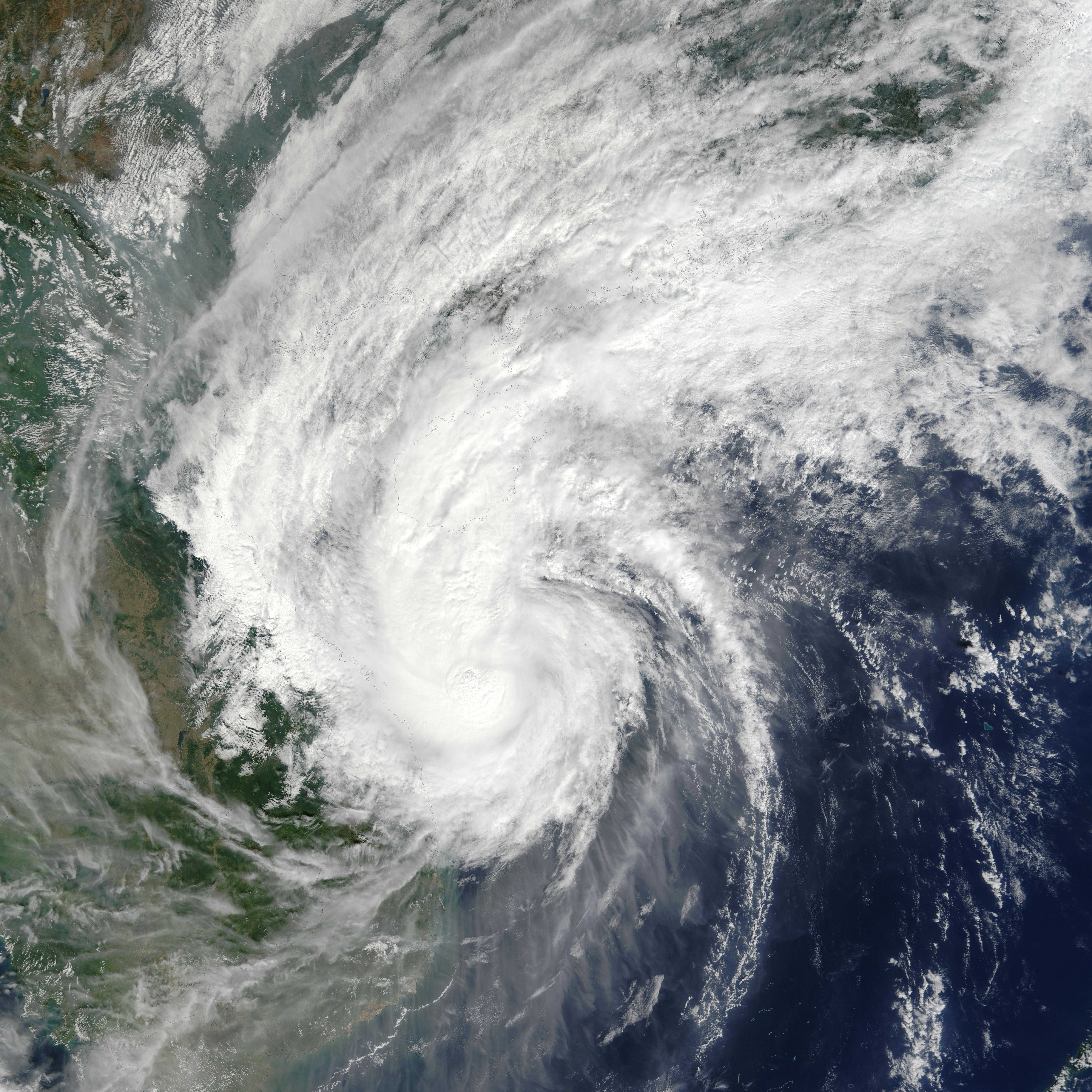
Track=Nepartak 2003 track.pngNovember 12
Dissipated=November 19
10-min winds=65
1-min winds=75
Pressure=970November 13 throughNovember 14 . It caused heavy flooding amounting to $197 million in damage and 4 casualties in the Philippines. Nepartak continued westward where it reached a peak of convert|85|mi/h|km/h|abbr=on winds. It turned northeastward, and dissipated overChina on the 19th. The central sections of Vietnam were hard hit, as 61 perished, and 32000 homes were inundated.Typhoon Lupit (Yoyoy)
Infobox Hurricane Small
Basin=WPac
Track=Lupit 2003 track.pngNovember 21
Dissipated=December 2
10-min winds=100
1-min winds=140
Pressure=915Typhoon which formed in the westernPacific Ocean west of thePhilippines onNovember 19 ,2003 . Lupit never struck the mainland but reached an extraordinary intensity over open water and left a trail of devastation across numerous islands in theFederated States of Micronesia . It reached sustained winds of 145 kts/165 mph.Lupit was a powerful Category 5 Super Typhoon at the time the image on the right was taken on
November 26 ,2003 and the main part of the typhoon was nearly 1,300 kilometers wide. If this storm could be picked up and placed over the United States, it would stretch from Virginia Beach inland as far as St. Louis, Missouri, or from Jacksonville, Florida, nearly all the way to Houston, Texas.The typhoon recurved northeast, becoming an extratropical storm late on
November 30 . Reintensification occurred, with the system bombing out over the next day to become a strong extratropical storm. The system moved to near Kamchatka onDecember 4 and then drifted east-northeast, ending up as a weakening cyclone over the Bering Sea onDecember 7 .Other storms
Tropical Depression 03W (Batibot)
Infobox Hurricane Small
Basin=WPac
WarningCenter=PAGASA
Track=3-W 2003 track.pngMay 17
Dissipated=May 20
10-min winds=35
1-min winds=25
Pressure=1000Batibot is the name of a Filipino children's television show similar to Sesame Street. An area of deep convection was noted late onMay 16 about convert|180|mi|km southwest ofPalau . On the 17th, it had developed into a tropical depression near 7.1N, 130.5E. After drifting northward to the east of the Philippines,JTWC and PAGASA upgraded the system to a tropical storm; Japan, Hong Kong, and the TaiwanCentral Weather Bureau never did. Weakening was evident late on the 19th as the cyclone drifted northward, and tropical depression status became unanimous as it passed convert|325|mi|km west ofYap . By late on the 20th, the depression was dissipating due to strong vertical wind shear.Tropical Depression Falcon
Infobox Hurricane Small
Basin=WPac
WarningCenter=PAGASA
Formed=July 9
Dissipated=July 9
10-min winds=30
Pressure=1004Tropical Depression Ineng
Infobox Hurricane Small
Basin=WPac
WarningCenter=PAGASA
Formed=July 30
Dissipated=July 31
10-min winds=25
Pressure=1004Tropical Storm Lakay
Infobox Hurricane Small
Basin=WPac
WarningCenter=PAGASA
Formed=August 18
Dissipated=August 20
10-min winds=35
Pressure=998Tropical Depression Quiel
Infobox Hurricane Small
Basin=WPac
WarningCenter=PAGASA
Formed=September 15
Dissipated=September 19
10-min winds=30
Pressure=1000Tropical Depression 18W
Infobox Hurricane Small
Basin=WPac
Track=18-W 2003 track.pngOctober 6
Dissipated=October 11
1-min winds=25
Pressure=1002Tropical Depression 19W
Infobox Hurricane Small
Basin=WPac
Track=19-W 2003 track.pngOctober 10
Dissipated=October 13
1-min winds=30
Pressure=1000October 12 before losing its identity in a frontal zone byOctober 13 . None of the Asian tropical cyclone warning centers regarded this low of subtropical origin as a tropical depression.Tropical Depression 22W (Ursula)
Infobox Hurricane Small
Basin=WPac
WarningCenter=PAGASA
Track=22-W 2003 track.pngOctober 21
Dissipated=October 24
10-min winds=30
1-min winds=25
Pressure=1002Tropical Storm 23W
Infobox Hurricane Small
Basin=WPac
Track=23-W 2003 track.pngOctober 21
Dissipated=October 28
1-min winds=35
Pressure=997Gulf of Thailand onOctober 21 . It tracked west-northwestward across theMalay Peninsula , ultimately hittingIndia as a minimal tropical storm. Though a weak storm that caused little damage, by crossing from the Western Pacific to the Indian Ocean, its track was a relatively rare event.Tropical Storm 27W (Zigzag)
Infobox Hurricane Small
Basin=WPac
WarningCenter=PAGASA
Track=27-W 2003 track.pngDecember 23
Dissipated=December 27
10-min winds=30
1-min winds=35
Pressure=997December 20 an area of disturbed weather formed to the west-southwest of Chuuk. Slowly getting better organized over the next few days, it was upgraded to a tropical depression late onDecember 23 . The system resisted vertical wind shear, and became a tropical storm very early onDecember 25 . The system moved generally to the southwest towards thePhilippines , eventually dissipating in the middle of the archipelago early onDecember 27 .http://msn.maybagyo.com/garyp_mgtcs/dec03sum.txt]torm names
Western North Pacific tropical cyclones are named by the RSMC Tokyo-Typhoon Center of the
Japan Meteorological Agency . Names are selected from the following sequential list, there is no annual list. Names were contributed by 13 members of theESCAP/WMO Typhoon Committee , except forSingapore . The 13 nations or territories, along withMicronesia , each submitted 10 names, which are used in alphabetical order by the English name of the country. The first storm of 2003 was named Yanyan and the final one was named Lupit.Philippines The
Philippine Atmospheric, Geophysical and Astronomical Services Administration (PAGASA) uses its own naming scheme for tropical cyclones within its area of responsibility. Lists are recycled every four years.ee also
*
List of Pacific typhoon seasons
*2003 Pacific hurricane season
*2003 Atlantic hurricane season
*2003 North Indian Ocean cyclone season
*South-West Indian Ocean cyclone seasons: 2002-03, 2003-04
*Australian region cyclone seasons: 2002-03, 2003-04
*South Pacific cyclone seasons: 2002-03, 2003-04References
External links
* [http://www.typhoon2000.ph Typhoon2000 Philippine typhoon website] .
* [http://www.typhoon2000.ph/plotting/PhilippineTyphoonChart.gifPhilippine Area of Responsibility] .
* [https://metocph.nmci.navy.mil/jtwc.html Joint Typhoon Warning Center] .
* [http://www.weather.gov.hk/informtc/sound/tc_pronunciatione.htm Meaning of Tokyo Typhoon Centre names] .
* [http://lwf.ncdc.noaa.gov/oa/climate/research/2003/aug/hazards.html Global Hazards and Significant Events - August 2003]
Wikimedia Foundation. 2010.