- Maidstone
-
For other uses, see Maidstone (disambiguation).
Coordinates: 51°16′19″N 0°31′44″E / 51.272°N 0.529°E
Maidstone 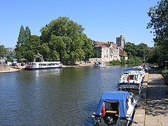
River Medway, Maidstone.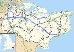
 Maidstone
Maidstone shown within KentPopulation 75,070 (2001) OS grid reference TQ765555 - London 32 mi (51 km) NW District Maidstone Shire county Kent Region South East Country England Sovereign state United Kingdom Post town MAIDSTONE Postcode district ME14–ME16 Dialling code 01622 Police Kent Fire Kent Ambulance South East Coast EU Parliament South East England UK Parliament Maidstone and The Weald/
Faversham and Mid KentList of places: UK • England • Kent Maidstone is the county town of Kent, England, 32 miles (51 km) south-east of London. The River Medway runs through the centre of the town linking Maidstone to Rochester and the Thames Estuary. Historically, the river was a source and route for much of the town's trade. Maidstone was the centre of the agricultural county of Kent, known as the Garden of England. There is evidence of a settlement in the area dating back to beyond the Stone Age.
The town is within the borough of Maidstone. In 2001, the town had a population of 75,070.
Maidstone's economy has changed over the years from being involved in heavy industry, to more light and service industries.
Contents
Toponymy
Saxon charters (c975) show the first recorded instances of the town's name; de maeides stana and maegdan stane with the possible meaning of either stone of the maidens, or possibly stone of the people. The latter meaning may refer to the nearby megalith around which gatherings would take place. The name evolved through medestan/meddestane as reported in the Domesday Book until, in 1610, the modern name appeared.[1] It has also been suggested that the name derives from stones set into the river to allow clothes to be rinsed in the cleaner water away from the banks of the river.[citation needed]
History
 Leeds Castle, four miles south of Maidstone town centre
 Main article: History of Maidstone
Neolithic finds have revealed the earliest occupation of the area; and the Romans have left their mark also: the road through the town and evidence of villas. The Normans set up a shire moot, and religious organisations established an abbey at Boxley, as well as hospitals and a college for priests. Today’s suburb of Penenden Heath became a place of execution in medieval times.
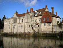 Archbishops Palace
 Maidstone Museum
Maidstone's charter as a town was first confirmed in 1549; although briefly revoked, a new charter in 1551 created the town as a borough. The town’s charter was ratified in 1619 under James I, and the coat of arms, bearing a golden lion and a representation of the river, was designed (in heraldic terms: "or, a fes wavy azure between three roundels gules, on a chief gules a leopard passant gardant or"). Recently these arms were added to by the head of a white horse (representing Invicta, the motto of the county of Kent), a golden lion and an iguanodon. The iguanodon relates to the local discovery in the 19th century of the fossilised remains of such a dinosaur: The remains are now displayed in the Natural History Museum in London.
During the Civil War a battle took place here in 1648, resulting in victory for the Parliamentarian forces. Andrew Broughton, who was Mayor of Maidstone in 1649 (and also Clerk to the High Court of Justice) was responsible for declaring the death sentence on Charles I, and today a plaque in Maidstone Town Centre memorialises Andrew as 'Mayor and Regicide' (a killer of kings).
Maidstone has had the right to a town gaol since 1604; the present prison lies north of the town centre and was completed in 1819. Army barracks have been a feature of the town since 1797, when the first was built. The present Invicta Barracks is home to the Royal Engineers 36 Engineer Regiment, which includes two Gurkha field squadrons.
From an economic point of view, Maidstone’s history has developed around the river, and also the surrounding countryside. Paper mills, stone quarrying, brewing and the cloth industry have all flourished here. The paper maker James Whatman and his son invented wove paper (Whatman paper) at Turkey Mill from 1740, an important development in the history of printing.[2]
Modern history
The modern town of Maidstone incorporates a number of previously outlying villages and settlements (see Geography below).
The county council offices, to the north of the town centre were built of Portland stone between 1910 and 1913. Maidstone General Hospital opened on the outskirts of the town in 1983, replacing West Kent General Hospital, which opened 150 years earlier in Marsham Street. The new Maidstone General Hospital is located just to the north of the former Oakwood Hospital (originally the Kent County Asylum) which closed in the mid-1990s.
Many of today's residents are employed within the retail, administrative or service sectors within the town; there are many industrial estates around the town providing employment. Some of the workforce commutes to other towns, including to London.
Governance
 County Hall, Kent County Council HQ
Previously covered by the single county constituency of Maidstone (once held by Benjamin Disraeli) until 1997 when boundary changes led to its break-up, the town is now divided between the constituencies of Maidstone and the Weald and Faversham and Mid Kent. The current Member of Parliament for Maidstone and the Weald is Conservative Helen Grant who replaced fellow Conservative and retiring incumbent Ann Widdecombe[3] in the 2010 General Election. Since 2001, the MP for Faversham and Mid Kent has been another Conservative, Hugh Robertson.
The town is within, and is the main town of, the local government district of Maidstone, which includes the surrounding rural areas. The town is divided into the twelve local government wards of Allington, Bridge, Downswood and Otham, East, Fant, Heath, High Street, Park Wood, Shepway North, Shepway South, South, and North.[4] These wards have thirty of the fifty-five seats on the Maidstone Borough Council. As of the 2010 Maidstone council election, 28 of the seats on the council were held by the Conservative party, 23 by the Liberal Democrats and 4 by independents.[5]
Maidstone Borough Council is responsible for running local services, such as recreation, refuse collection and council housing;[6] while Kent County Council is responsible for education, social services and trading standards. Both councils are involved in town planning.
Geography
 A former millpond on the River Len, Mill Street/Palace Avenue Maidstone.
 Lower Chrisbrook Mill mill pond and Upper Chrisbrook Mill, on the Loose Stream.
The town is situated at a point where the River Medway has previously flowed in a generally west-east direction; now, having been joined by the Rivers Teise and Beult, its course changes to a northerly one. As it does so, it cuts through the ridge formed by the Greensand, so that the town occupies a site on two opposite hills; the more easterly one containing the town centre. Beyond that, and still higher, is Penenden Heath.
The River Len joined the River Medway at Maidstone; though a short river it provided the water to drive numerous watermills. The Loose Stream, that rose at Langley and joined at Tovil powered over 30 mills. The resultant mill ponds on these rivers, are a prominent feature of the landscape.
Because of that situation, Maidstone had an industrial base, and became a nodal point for communications, both along the ridge and beside the river, and on the river itself. Roads radiate from here, connecting with Sevenoaks and Ashford (the A20); the Medway towns and Hastings (A229); Tonbridge (A26) and Tenterden (A274). All of these roads were served by the Turnpike trusts in the 18th/19th centuries.
The two railway routes, in spite of the fact that Maidstone is the county town, are not principal ones, due to an accident of history. There are two principal stations: Maidstone East, the more northerly of the two, connects with London and Ashford; whilst Maidstone West is on the Medway Valley Line.
Although the River Medway was historically responsible for the growth of the town, because of its capability to carry much of the area's goods, it is no longer a commercial stream. There is however a great deal of tourist traffic upon it.
As with most towns, Maidstone has continued to grow. In doing so it has incorporated hitherto separate settlements, villages and hamlets within its boundaries. These include Allington, Barming, Bearsted, Penenden Heath, Sandling, Tovil and Weavering Street. Housing estates include Grove Green, Harbourland, Ringlestone, Roseacre, Shepway and Vinters Park.
Maidstone was at one time a centre of industry: brewing and paper making being among the most important. Nowadays smaller industrial units encircle the town.[7] The site of one of the breweries is now Fremlin Walk shopping centre. The pedestrianised areas of the High Street and King Street run up from the river crossing at Lockmeadow; Week Street and Gabriel’s Hill bisect this route.
Climate
As with the rest of the British Isles, Kent experiences a maritime climate with cool summers and mild winters. The nearest official Met Office weather station for which online records are available is at nearby East Malling, about 3 miles west of Maidstone town centre.
East Malling's highest temperature of 37.4 °C (99.3 °F) was recorded in August 2003.[8] East Malling also holds the record for the mildest January day in South East England, 17.4 °C (63.3 °F), also set in 2003.[9] The lowest temperature recorded in recent years was −10.7 °C (12.7 °F) on the 20th December 2010.[10]
Climate data for East Malling 1961-1990 (Weather station 3 miles (5 km) to the West of Maidstone) Month Jan Feb Mar Apr May Jun Jul Aug Sep Oct Nov Dec Year Average high °C (°F) 6.8
(44.2)7.1
(44.8)9.8
(49.6)12.4
(54.3)16.3
(61.3)19.5
(67.1)21.6
(70.9)21.5
(70.7)18.9
(66.0)15.1
(59.2)10.2
(50.4)7.8
(46.0)13.9 Average low °C (°F) 1.2
(34.2)1.2
(34.2)2.4
(36.3)4.2
(39.6)6.9
(44.4)9.8
(49.6)11.9
(53.4)11.6
(52.9)9.5
(49.1)7.0
(44.6)3.6
(38.5)2.1
(35.8)5.9 Precipitation mm (inches) 62
(2.44)41
(1.61)49
(1.93)46
(1.81)47
(1.85)50
(1.97)45
(1.77)48
(1.89)60
(2.36)60
(2.36)67
(2.64)65
(2.56)640
(25.2)Sunshine hours 51.6 69.4 113.9 148.5 201.0 204.8 201.0 195.6 151.4 114.4 69.3 46.6 1,567.5 Source: Met Office[11] Demography
Maidstone compared Maidstone Maidstone district England Population 75,070 138,948 49,138,831 Foreign born 5.9% 5.2% 9.2% White 97% 97% 91% Asian 1.5% 1.1% 4.6% Black 0.4% 0.2% 2.3% Christian 74% 76% 72% Muslim 0.8% 0.5% 3.1% Hindu 0.7% 0.5% 1.1% Source: 2001 UK census As of the 2001 UK census, Maidstone town wards had a total population of 75,070, and a population density of 28 residents per hectare. The town had 31,142 households; of which, 38% were married couples, 29% were individuals, 10% were cohabiting couples, and 9% were lone parent families. 14% of households had someone living alone at pensionable age.[12]
The ethnicity of the town was given as 96.6% white, 0.9% mixed race, 0.3% Chinese, 1.5% other Asian, 0.4% Black and 0.3% other. The place of birth of the town's residents was 94.1% United Kingdom (91.4% England), 0.6% Republic of Ireland, 0.6% Germany, 1.3% other European countries, 1.7% Asia, 0.9% Africa and 0.8% elsewhere.[12]
Religion was recorded as 73.9% Christian, 0.8% Muslim, 0.7% Hindu, 0.3% Buddhist, 0.14% Sikh and 0.11% Jewish. 15.8% were recorded as having no religion, 0.6% had an alternative religion, and 7.7% did not state their religion.[12]
Economy
 Fremlin Walk
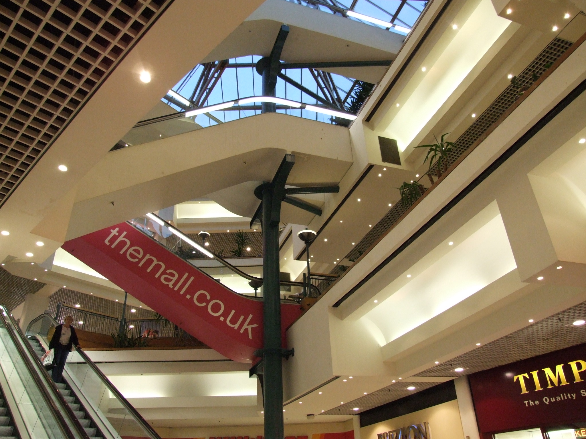
 The Mall Maidstone, formerly Chequers, Shopping Centre
 The Stag, by Edward Bainbridge Copnall, outside the Lockmeadow Centre
Industry
Today Aylesford (on the northwest side of Maidstone) has the largest paper recycling factory in Europe, manufacturing newsprint for the newspaper industry.
Until 1998, the Sharps toffee factory (later part of Cadbury Trebor Basset), was in central Maidstone and provided a significant source of employment.
Loudspeaker manufacturer KEF was founded in 1961 in Maidstone on the premises of a metal working operation called Kent Engineering & Foundry (hence KEF). Today, KEF still occupies the same river-bank site. In the late 1990s KEF manufactured a loudspeaker called “the Maidstone”.
The town centre has the largest office centre in the county and the area is a base for the paper and packaging industry. Many high-technology firms have set up on surrounding business parks.
Southern Water and Mid Kent Water operate the Maidstone water system.
Shopping/Retail
The town is ranked in the top five shopping centres in the south east of England for shopping yields and with more than one million square feet of retail floor space, in the top 50 in the UK.[13] Much of this space is provided the two main shopping centres in the town, the 535,000 square feet (49,700 m2) The Mall Maidstone and the 32,500 square metres (350,000 sq ft) Fremlin Walk which opened in 2006.[14]
Other recent developments include the riverside Lockmeadow Centre, which includes a multiplex cinema, restaurants, nightclubs, bowling alley, and the town's market square. The leisure industry is a key contributor to the town's with the night-time economy worth £75m per annum.[13]
Employment
As of the 2001 UK census, 45.2% of the town's residents aged 16–74 were employed full-time, 12.7% employed part-time, 7.6% self-employed and 2.5% unemployed, while 2.3% were students with jobs, 3.0% students without jobs, 12.9% retired, 6.6% looking after home or family, 3.8% permanently sick or disabled and 3.2% economically inactive for other reasons. These figures were roughly inline with the national average.[12]
Employment, by industry, was 19% retail; 13% real estate; 11% manufacturing; 9% construction; 7% transport and communications; 10% health and social work; 8% public administration; 7% education; 5% finance; 4% hotels and restaurants; 1% agriculture; 1% energy and water supply; and 5% other. Compared to national figures, Maidstone had a relatively high percentage of workers in construction and public administration, and a relatively low percentage in agriculture.[12]
According to the Office for National Statistics estimates, the average gross income of households in Maidstone between April 2001 and March 2002 was £595 per week (£31,000 per year).[12]
Army barracks
Army barracks have been a feature of the town since 1797, when the first was built. The present Invicta Barracks is home to the Royal Engineers 36 Engineer Regiment, which includes two Gurkha field squadrons.
On 29 September 1975 a local pub serving the barracks - The Hare and Hounds - was damaged by a bomb during the IRA campaign against the English mainland.[15] Another pub - The White Rabbit - now occupies the former Officers’ Mess of the original barracks, now a listed building.
Transport and communications
 Residential developments along the river upstream of the Palace.
One of the first roads in Kent to be turnpiked was that from Rochester to Maidstone, in 1728, giving some indication of the town’s importance. The A20 runs through the town and the M20 motorway runs to the north. Originally opened in 1960 as the Maidstone Bypass, A20(M) this was the first motorway standard road to be constructed south of London. Maidstone is a hub for major roads such as the M20 motorway, the A229, A249, A20 and A26. The M2 motorway is also a short distance to the north and the A21 is not too far away. The historic centre of the town is largely pedestrianised or of restricted access to private vehicles.
The River Medway had, until the coming of better roads and the railways, long been one of the principal means of transporting goods to and from Maidstone. Improvements had been made in about 1730 to the River Medway, so that barges of 40 tons could get upriver to East Farleigh, Yalding and even Tonbridge. This meant that a good deal of trade, including corn, hops, fodder, fruit, stone and timber passed through the town, where there were several wharfs.
The medieval stone bridge was replaced in 1879 to give better clearance: it was designed by Sir Joseph Bazalgette. A second bridge, St. Peter's Bridge, was built in 1977.
Today the river is of importance mainly to pleasure-boat owners and the considerable number of people living on houseboats. For many years there has been a river festival during the last weekend in July, and a millennium project inaugurated the Medway River Walk, the Medway Park and a new footbridge linking the former cattle market (which is now a multiplex cinema and nightclub) west of the river to the shopping area to the east.
Bus transport in Maidstone is provided by Arriva Southern Counties and Nu-Venture transport companies. Bus services are centred on High Street, King Street and the Chequers Bus Station adjacent to the Mall shopping centre. Weekday commuter coach services 781 and 784 between Maidstone and London are operated by Chalkwell Coaches of Sittingbourne.

In 2004 the centenary of Maidstone Corporation Transport was marked with several events, looking back at several historic operators of transport in Maidstone, and featuring a preserved trolleybus from the former Maidstone trolleybus system.
Former bus operators in Maidstone include: Maidstone & District Motor Services Ltd (M&D); Maidstone Borough Council Transport, later Boro'line Maidstone; and Bygone Buses.
When the railways were built in the 1840s, Maidstone was not well served. It was reported at the time that inhabitants were bitterly opposed to the railway: the mayor suggesting that “Maidstone will be ruined as a commercial town”. It was said that wharfingers and corn and coal merchants would be hardest hit.
In the event, in 1842, the South Eastern Railway, in its haste to reach the Channel ports of Folkestone and Dover, put its main line through Tonbridge and Ashford, some 6 miles (9.7 km) to the south. A station named Maidstone Road was built in an isolated spot called Paddock Wood, from where coaches were run to the county town.
 The 1874 Maidstone East line crossing the River Medway; also on the bridge is a footpath connecting Maidstone East with Maidstone Barracks.
Two years later a branch line was built to Maidstone. In 1846 another branch line (the Medway Valley Line) connected Strood with the town. It was not until 1874 that the line from London arrived; and another ten years before Ashford was connected by rail. There are three stations: Maidstone West and Maidstone Barracks on the Medway Valley Line (whose platforms are visible one from the other); and Maidstone East on the Ashford line.
In 1905, a railway was authorised under the 1896 Light Railways Act to link Maidstone with Sutton Valence and Headcorn, linking with the Kent & East Sussex Railway. The only part of the Headcorn & Maidstone Junction Light Railway ever built was a short branch serving the paper mills at Tovil.
Two long-distance footpaths are easily accessible from Maidstone. The Medway Valley Walk between Tonbridge and Gillingham passes through the town, following the banks of the river. The North Downs Way, which incorporates the Pilgrims' Way to Canterbury, runs for 153 miles (246 km) between Farnham, Surrey and Dover, passing about five miles (8 km) to the north and west.
Education
The town of Maidstone has fifteen secondary schools; twenty-three primary schools; and two special schools. Two of the secondary schools, Maplesden Noakes and Invicta Grammar School, have been awarded Business and Enterprise College status.
Alumni at Maidstone Grammar School include James Burke, television presenter, and Lord Beeching, responsible for cutting British railway routes. William Golding, author of Lord of the Flies was a teacher there. Also in Maidstone is a regional campus of the University for the Creative Arts (formerly Kent Institute of Art & Design) at which the British artist Tracey Emin, and the Graphic designers Toby Dison, Tony Rolfe, Andy Wall and Hassain Rauf began their artistic educations.
Maidstone Grammar School for Girls is also situated in the town.
Maidstone has two independently/non-government funded Academies. Cornwallis Academy (formerly The Cornwallis School) and New Line Learning Academy's (formerly Oldborough Manor School and Senacre Technology College) which were all State Schools. The New Line Learning Academies will soon form one Academy, the Senacre School has been knocked down and housing built on the site, and all activities have moved to the Oldborough site, which will then be re-built. Cornwallis Academy will also be re-built, at a cost estimated to be over £62M.
Shaun Williamson, TV actor, attended the local Catholic Seconday School, St. Simon Stock School. The school serves Catholic families throughout the whole of mid-Kent.
As of the 2001 census, 15.7% of the town's residents aged 16–74 had a higher education qualification or the equivalent, below the national average of 19.9%. 27.5% had no academic qualifications, compared to the national figure of 28.9%.
Religion
 All Saints Church
In 2001, the religions of the town's residents were recorded [12] as 73.9% Christian, 0.8% Muslim, 0.7% Hindu, 0.3% Buddhist, 0.14% Sikh and 0.11% Jewish. 15.8% were recorded as having no religion, 0.6% had an alternative religion, and 7.7% did not state their religion.
There are a number of churches and other religious congregational buildings within the town of varying denominations.[16]
All Saints Church in the centre of Maidstone was the collegiate church of the College of All Saints built in 1395 next to the Archbishop's Palace. It is a landmark building within the town and is notable for being one of the largest and widest Parish Churches in England. It contains a monument to Sir Jacob Astley, the Royalist Civil War soldier and a memorial to Lawrence Washington, great-uncle of George Washington's great-great-grandfather that includes the stars and stripes in the family coat of arms [17]
Culture
Twinning
 Maidstone is twinned with Beauvais in Picardy, France.
Radio and television
Maidstone has long held links to local radio. There are three radio stations: Invicta Sound (now Heart Kent) used to broadcast from studios in Earl Street; and Hospital Radio Maidstone is one of the longest serving hospital radio stations in the UK.
KMFM Maidstone, formerly CTR 105.6, is the local commercial station for the town - having once broadcast from studios in Mill Street, it now broadcasts from the studios of sister station KMFM Medway. It is part of the KM Group who acquired the station in October 2006.
A new version of former pirate radio station Radio Caroline, broadcasts (via Sky and the internet) from The Maidstone Studios, in the Vinters Park area of the town.
The town is home to the Maidstone Studios, an independent television production base that was once home to the former ITV company TVS in Vinters Park.
Theatre
 The Exchange
Theatres in Maidstone include: The Hazlitt Theatre; RiverStage; The Exchange Studio (previously known as ‘‘The Corn Exchange’’); and the Hermitage Millennium Amphitheatre.
Literature
Maidstone is mentioned several times in Ian Flemming's 1955 James Bond novel, Moonraker. Specifically the villain Hugo Drax passes through King Street and Gabriels Hill and later stops at the Thomas Wyatt Hotel.
Museums
- Maidstone Museum & Art Gallery
- Kent Life
- Tyrwhitt-Drake Museum of Carriages
Martian crater
Following the NASA tradition of naming craters on Mars after small towns, the Maidstone crater was added to the list of Martian geographical features in 1976.[18][19]
Sport
 Maidstone celebrate winning the Kent League title in 2006
Maidstone United football team was formed in 1897, and has had mixed fortunes in recent years. The peak of the club's achievement was gaining promotion to the Football League in 1989 after many years of success in non-league football. However, the club could not bring their own London Road Ground up to Football League standards so they ground-shared at Dartford's Watling Street stadium and played their games there. The club could not keep up with the financial pressures of the Football League and folded in 1992. A new club was formed and made its way from the Kent County League Division 4 to the Isthmian (Ryman) Premier Division, and currently compete in the Ryman Division One South. The club play at Sittingbourne F.C.'s Bourne Park stadium. However, the club, recently under new ownership, look forward to moving in to their new ground at James Whatman Way in 2012. Construction on the stadium started in September 2011.
Maidstone Hockey Club is one of the oldest field hockey clubs in the country, founded in 1878.[20] For the 2011/12 season, the Ladies' 1st XI play in the National League East Conference, having won the East Premier League the previous season,[21] and the Men's 1st XI play in the South Hockey League 1st XI Premier League Division 2.[22] The Men's and Women's 1st squad were both represented in the Indoor England Hockey League Division 2 England Hockey League, with the Men having previously won the Division 2 title in 2008/09.[23][24] In total, the club has 7 men's sides and 4 women's sides playing at all levels of National, regional, and County leagues.
Maidstone Rugby Football Club is one of the oldest rugby clubs in the country, founded in 1880.[25] The club runs 6 senior men's sides and a junior section.
Kent County Cricket Club played occasional matches on pitches at Mote Park for some 150 years until 2005. Mote Park is the town's largest park and includes a number of recreational and sport facilities. The Lashings World XI exhibition cricket team is based in Maidstone and has included a number of high-profile professional cricketers.[26]
Maidstone Sailing Club are a small club that sail on Mote Park lake. Maidstone also has a rowing club, a martial arts school, a tennis club, an athletics club, an American football team, and a basketball club.
A baseball team, the Kent Mariners, are also based in the town. They play in the BBF AA South division.
Notable people
- Dan Abnett, author
- Robert Blatchford, socialist campaigner, journalist and author
- Daniel Blythe, author
- Julius Brenchley, explorer
- Michael Chaplin, artist and author
- Mackenzie Crook, actor
- David Edwards, journalist
- Robert Fisk, journalist and author
- Guy Fletcher, musician
- Samantha Giles, actress
- Albert Goodwin, artist
- Alexander Henry Green, geologist
- Christopher Newman Hall, priest and anti-slavery campaigner
- Jon Harley, footballer
- Tony Hart, artist and TV presenter
- William Hazlitt, essayist and critic
- Edmund Walker Head, colonial administrator
- Noel Howlett, actor
- John Jenkins, composer
- Bill Lewis, artist, storyteller, poet and mythographer
- Malcolm MacDonald, diplomat and politician
- Carol McGiffin, presenter
- John Monckton, lawyer, Town Clerk of London 1873-1902
- Nicky Moore, rock and blues musician
- Frederic J. Mouat, surgeon
- Ross Noble, comedian
- John Orrell, theatre historian and professor
- Anthony Pawson, microbiologist
- Mike Ratledge, musician
- Vic Reeves, comedian
- Ralph Steadman, illustrator
- Simon Stock, monk and saint
- George Tolhurst, composer
- Andy Townsend, footballer
- Scott Wagstaff, footballer
- Shaun Williamson, actor ("Barry" from EastEnders)
- Peter Wolfe, musician
- William Woollett, engraver
- Nan Youngman, painter
- Thomas Wyatt, 16th century poet
- Thomas Culpepper, lover of Queen Katherine Howard
Surrounding Areas
The Maidstone Borough encompasses many rural parishes.

Aylesford Boxley
BredhurstThurnham
DetlingBarming 
Bearsted
Hollingbourne Maidstone

Tovil
CoxheathLoose
LangleyOtham
LeedsSee also
External links
References
- ^ "Origin of place name". Hereshistorykent.org.uk. http://www.hereshistorykent.org.uk/DisplayArticle.cfm?placeID=288&categoryID=3&placename=Maidstone. Retrieved 2011-08-05.
- ^ Roberts, Matt T.; Etherington, Don. "Whatman, James (1741-1798)". Bookbinding and the conservation of books; A dictionary of descriptive terminology.. U.S. Government Printing Office. ISBN O-84440-0366-O. http://cool.conservation-us.org/don/dt/dt3773.html.
- ^ "Widdecombe to stand down as MP". London: Guardian.co.uk. 2007-10-08. Archived from the original on 2007-10-15. http://web.archive.org/web/20071015161619/http://www.guardian.co.uk/uklatest/story/0,,-6979102,00.html. Retrieved 2007-11-23.
- ^ "Election Maps". Ordnance Survey. Archived from the original on 2007-11-13. http://web.archive.org/web/20071113101731/http://www.election-maps.co.uk/formFrame.htm. Retrieved 2007-11-23.
- ^ "Maidstone". BBC News Online. 2009-04-19. http://news.bbc.co.uk/1/shared/election2010/council/html/3716.stm. Retrieved 11 March 2011.
- ^ "Maidstone Borough Council". Maidstone Borough Council. http://www.maidstone.gov.uk. Retrieved 2007-03-29.
- ^ "Locateinmaidstone.com". Locateinmaidstone.com. 2011-05-23. http://www.locateinmaidstone.com/Default.aspx?page=7. Retrieved 2011-08-05.
- ^ "2003 Heatwave". MetOffice. http://www.metoffice.gov.uk/climate/uk/interesting/aug03maxtemps.html.
- ^ "2003 January". MetOffice. http://www.metoffice.gov.uk/climate/uk/interesting/2627jan03maxtemps.html.
- ^ "2010 December". MetOffice. http://metofficenews.wordpress.com/2010/12/20/.
- ^ "East Malling 1961-90 averages". Met Office. http://web.archive.org/web/20010210223336/http://www.metoffice.gov.uk/climate/uk/averages/sites/24.html. Retrieved 16 sep 2011.
- ^ a b c d e f g "Neighbourhood Statistics". Statistics.gov.uk. http://neighbourhood.statistics.gov.uk/dissemination/LeadHome.do;jsessionid=ac1f930bce6a711447e60ba4446bb56c21648d42c51.e38PbNqOa3qRe38OaNeKahqMai1ynknvrkLOlQzNp65In0?bhcp=1. Retrieved 2007-11-23.
- ^ a b http://www.alexandrapatrick.co.uk/userfiles/file/Maidstone.pdf
- ^ The ABB Group ‘‘Fremlin Walk’’ Electrical Contractor
- ^ BBC Kent History retrieved 11 July 2007
- ^ "List of churches in Maidstone". Visit.maidstone.btinternet.co.uk. http://www.visit.maidstone.btinternet.co.uk/churches.htm. Retrieved 2011-08-05.
- ^ Harris, Brian (2006) Harris's Guide to Churches and Cathedrals ISBN 9780091912512
- ^ "Mars crater named after Tooting". BBC News. 1998-01-11. http://news.bbc.co.uk/1/hi/england/london/4395660.stm. Retrieved 2010-11-28.
- ^ "IAU Gazetteer of Planetary Nomenclature". http://planetarynames.wr.usgs.gov/Feature/3594.
- ^ Maidstone Hockey Club
- ^ "EML Latest results&tables NE". East-hockey2.co.uk. http://www.east-hockey2.co.uk/showdata/leaguetables/EWLtables.asp. Retrieved 2011-08-05.
- ^ "Premier - Division 1". South-league.com. 2011-04-16. http://www.south-league.com/shl_report.asp?League=1&Dates=0. Retrieved 2011-08-05.
- ^ "Englandhockey.co.uk". Englandhockey.co.uk. http://www.englandhockey.co.uk/fl/comps/cv.asp?d=14752. Retrieved 2011-08-05.
- ^ "Englandhockey.co.uk". Englandhockey.co.uk. 2009-01-22. http://www.englandhockey.co.uk/news.asp?section=000100010002&itemid=4974&search=Indoor+division+2+maidstone. Retrieved 2011-08-05.
- ^ "Maidstone Rugby Club". Maidstonerugby.org.uk. http://www.maidstonerugby.org.uk. Retrieved 2011-08-05.
- ^ Lashings CC[dead link]
Towns and villages in the Maidstone borough of Kent, England 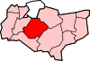 Allington · Barming · Bearsted · Bedmonton · Benover · Bexon · Bicknor · Boughton Green · Boughton Malherbe · Boughton Monchelsea · Boxley · Bredhurst · Broomfield · Caring · Chainhurst · Chart Sutton · Chegworth · Collier Street · Coxheath · Detling · Downswood · East Barming · East Farleigh · East Sutton · Fairbourne Heath · Frinsted · Grove Green · Harrietsham · Hawkenbury · Headcorn · Hollingbourne · Horden · Hucking · Hunton · Kingswood · Kit's Coty · Laddingford · Langley · Leeds · Lenham · Linton · Loose · Lordswood · Maidstone · Marden · Marley · Milebush · Nettlestead · Nettlestead Green · Otham · Otterden · Park Wood · Platt's Heath · Penenden Heath · Pollhill · Ringlestone (hamlet) · Ringlestone (suburb) · Sandling · Sandway · Shepway · Sutton Valence · Staplehurst · Stockbury · Teston · Thurnham · Tovil · Ulcombe · Walderslade · Weavering · West Farleigh · Wichling · Wormshill · Yalding
List of places in Kent Ceremonial county of Kent Kent Portal Unitary authorities Boroughs or districts Major settlements Ashford, Broadstairs, Canterbury, Chatham, Cranbrook, Dartford, Deal, Dover, Edenbridge, Faversham, Folkestone, Fordwich, Gillingham, Gravesend, Greenhithe, Herne Bay, Hythe, Lydd, Maidstone, Margate, Minster, New Romney, Northfleet, Paddock Wood, Queenborough, Rainham, Ramsgate, Rochester, Royal Tunbridge Wells, Sandwich, Sevenoaks, Sheerness, Sittingbourne, Snodland, Southborough, Strood, Swanley, Swanscombe, Tenterden, Tonbridge, Walmer, West Malling, Westerham, Westgate-on-Sea, Whitstable
See also: List of civil parishes in KentRivers See: Rivers of KentTopics Categories:- Maidstone (borough)
- County towns in England
- Market towns in Kent
- Towns in Kent


Wikimedia Foundation. 2010.