- Ab Kettleby
-
For other places with a similar name, see Kettleby (disambiguation).
Coordinates: 52°47′59″N 0°55′31″W / 52.799806°N 0.925279°W
Ab Kettleby 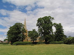
St. James Church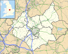
 Ab Kettleby
Ab Kettleby shown within LeicestershirePopulation 501 (2001 Census) OS grid reference SK724230 - London 96 mi (154 km) SSE District Melton Shire county Leicestershire Region East Midlands Country England Sovereign state United Kingdom Post town MELTON MOWBRAY Postcode district LE14 Dialling code 01664 Police Leicestershire Fire Leicestershire Ambulance East Midlands EU Parliament East Midlands List of places: UK • England • Leicestershire Ab Kettleby is a village and civil parish within the Melton district of Leicestershire, England. It is 3 miles (4.8 km) north of Melton Mowbray, along the A606 road, and has a population of 501.[1]
Ab Kettleby is in north Leicestershire, not far from the town of Melton Mowbray and three miles from the border with Nottinghamshire. Situated 460 feet (140 m) above sea level it lies close to the neighbouring hamlets of Wartnaby and Holwell that form part of the civil parish of Ab Kettleby.
Contents
History
See also: History of Leicestershire St James'Church
Ab Kettleby was first recorded in the Domesday Book as Chetelbi,[2] though a Roman mosaic and pavement was found beneath the churchyard, indicating the antiquity of the village beyond 1086.[3]. Unfortunately this previous building and a ditch running from north to south across the nave have caused serious structural problems for the church that require expensive attention. The church has a congregation that is determined to save this ancient church and is actively involved in the organisation of events to raise funds.
St. James Church has a Norman font, and a memorial to Everard Digby of the Gunpowder Plot.
Other
 The Sugar Loaf.
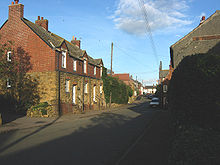 Houses on Main St.
The parish has a primary school, a public house named after Sugarloaf Mountain, a community centre, a guest house, a 17th-century manor house, and medieval farmhouses and farm buildings. One of those farms was home to racehorse Desert Orchid for several years.
It also has a village duck pond next to a large horse-chestnut tree and megalithic spring. A public telephone box, once a common site throughout the UK but now a protected building, has been released to the protection of Ab Kettleby's council who are looking for ways to preserve and pay reverence to this icon of British life.[4]
Also within the boundaries of this village is an Holy Well which is near the village pond, surrounded by orange-coloured ironstone cottages indicative of this area. According to Tony at Megalithic Portal [5]. . . " Traditionally, it provided a good supply and never ran dry. After the construction of new houses nearby in 1992 the well dried up, but by 2001 was flowing copiously again. Unfortunately in 2001 an ugly metal grating was fitted that blocks all access to the water. The present well structure is a truncated pyramid just over a yard high and surmounted by what at first glance appears to be an upturned font but was probably a previous basin for the well."
References
- ^ United Kingdom Census 2001. "Ab Kettleby (Parish)". neighbourhood.statistics.gov.uk. http://www.neighbourhood.statistics.gov.uk/dissemination/LeadAreaSearch.do?a=7&c=ab+kettleby&i=1001&m=0&enc=1&areaSearchText=ab+kettleby&areaSearchType=16&extendedList=true&searchAreas=Search. Retrieved 2007-06-07.
- ^ Williams, Ann; G H Martin. Domesday Book: A Complete Translation. London: Penguin. p. 1303. ISBN 978-0-14-143994-5.
- ^ http://www.meltontimes.co.uk/news/Roman-villa-uncovered-beneath-old.6462166.jp
- ^ http://abkettleby.leicestershireparishcouncils.org/20481.html
- ^ http://www.megalithic.co.uk/user.php?op=userinfo&uname=enkidu41
External links
Categories:- Civil parishes in Leicestershire
- Villages in Leicestershire


Wikimedia Foundation. 2010.