- Molucca Sea
-
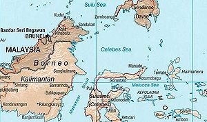
 Location of the Molucca Sea within Southeast Asia
Coordinates: 0°25′S 125°25′E / 0.417°S 125.417°E
The Molucca Sea (Indonesian: Laut Maluku) is located in the western Pacific Ocean, within the country of Indonesia. The region is rich in coral and has many diving sites.
Contents
Location
The Molucca Sea borders the Banda Sea to the south and the Celebes Sea to the north.
The islands bordering the Molucca Sea include Halmahera to the north east, Buru and Ceram in the centre, and Sulawesi to the west. The Talaud Islands to the north are the general limit of the sea, though the Molucca Sea Plate, the tectonic plate named after the sea, extends further north.
The International Hydrographic Organization (IHO) defines the "Molukka Sea" [sic] as being one of the waters of the East Indian Archipelago. The IHO defines its limits as follows:[1]
On the North. By a line from the Northeast extreme of Celebes [Sulawesi] through the Siau Islands to the South point of Sangi (3°21′N 125°37′E / 3.35°N 125.617°E) thence to the Southern extreme of the Talaud Group, through these islands to their Northeastern extreme (4°29′N 126°52′E / 4.483°N 126.867°E) and thence a line to Tanjong Sopi, the Northern point of Morotai Island.
On the East. By the West coast of Morotai from Tanjong Sopi as far South as Wajaboela (2°17′N 128°12′E / 2.283°N 128.2°E), thence a line to the Northern point of Halmahera and down its West coast to Tanjong Libolo, its Southern extreme.
On the South. A line from the Southern extreme of Halmahera to the North point of Bisa (Setile) Island, thence to the Northern extreme of Obi Major, through this island to Tanjong Ake Lamo, its Southwestern point, thence to Tanjong Dehekolano, the Eastern extremity of the Soela [Sula] Islands, along their Northern coasts to Tanjong Marikasoe, the Western extreme, thence a line to the Southeast point of Banggai Island (1°43′S 123°36′E / 1.717°S 123.6°E).
On the West. The East coasts of Banggai and Peleng Islands to North Bangkalan (1°10′S 123°18′E / 1.167°S 123.3°E) thence a line to Tg. Botok (Celebes) (1°04′S 123°19′E / 1.067°S 123.317°E) round the coast to Tg. Pasir Pandjang (0°39′S 123°25′E / 0.65°S 123.417°E) and across to Tg. Tombalilatoe (123°21'E) on the opposite coast, thence up the East coast to Tg. Poeisan, the Northeastern extreme of Celebes.
History
The Molucca sea was an active area for spice trade, and was controlled by 4 sultanates.
Earthquakes
The sea is a very seismically active area due to the Molucca Sea Plate.
See also
- Strait of Malacca, which is west of Singapore.
Notes
- ^ "Limits of Oceans and Seas, 3rd edition". International Hydrographic Organization. 1953. http://www.iho-ohi.net/iho_pubs/standard/S-23/S23_1953.pdf. Retrieved 7 February 2010.
Sea Strait - Alas Strait
- Alor Strait
- Badung Strait
- Bali Strait
- Bangka Strait
- Berhala Strait
- Dampier Strait
- Gaspar Strait
- Karimata Strait
- Laut Strait
- Lombok Strait
- Madura Strait
- Makassar Strait
- Malacca Strait
- Mentawai Strait
- Ombai Strait
- Riau Strait
- Rupat Strait
- Sape Strait
- Selayar Strait
- Singapore Strait
- Sumba Strait
- Sunda Strait
- Torres Strait
- Wetar Strait
Gulf - Balikpapan Gulf
- Bintuni Gulf
- Gulf of Boni
- Cenderawasih Gulf
- Jakarta Bay
- Lampung Gulf
- Pelabuhanratu Gulf
- Saleh Gulf
- Semangka Gulf
- Tolo Gulf
- Tomini Gulf
Categories:- Seas of Indonesia
- Molucca Sea
- Maluku Islands and New Guinea (Indonesia) geography stubs


Wikimedia Foundation. 2010.