- Ooty
-
Ooty
Udhagai
Queen of Hill Stations — town — 
Coordinates 11°24′43″N 76°41′45″E / 11.411842°N 76.6959°ECoordinates: 11°24′43″N 76°41′45″E / 11.411842°N 76.6959°E Country India State Tamil Nadu District(s) The Nilgiris Civic agency Udagamandalam Municipality Corporation Time zone IST (UTC+05:30) Area
• 2,240 metres (7,350 ft)[1]
Climate
• Precipitation
TemperatureTropical wet (Köppen)
• 1,237 mm (48.7 in)
• 20 °C (68 °F)Footnotes- Temperature from Batchmates.com[2]
Ootacamund
 listen (help·info) (officially, Udagamandalam Tamil: உதகமண்டலம் sometimes abbreviated to Udhagai Tamil: உதகை or Ooty listen (help·info)), is a town, a municipality and the district capital of the Nilgiris district in the Indian state of Tamil Nadu. Ootacamund is a popular hill station located in the Nilgiri Hills. Originally occupied by the Todas, the area came under the rule of the East India Company at the end of the 18th century. Today the town's economy is based on tourism and agriculture, with manufacturing of medicines and photographic film also present. The town is connected to the rest of India by road and rail, and its historic sites and natural beauty attract tourists.
Etymology
The origin of the name Udhagamandalam is obscure. The first mention of the place occurs in a letter of March 1821 to the Madras Gazette by an unknown correspondent as Wotokymund.[3] In early times it was called OttaikalMandu "mund" is the Tamil word for a Toda village, and the first part is probably a corruption of the local name for the central region of the Nilgiri Plateau.[4] Another likely origin of the stem of the name (Ootaca) comes from the local language where Otha-Cal literally means Single Stone. This is perhaps a reference to a sacred stone revered by the local Toda people. The name probably changed under British rule from Udhagamandalam to Ootacamund, later shortened to Ooty.[5]
History
 Front of Ootacamund Club, 1905.
Ooty, which is deep within the Nilgiri hills, is also known as The Blue Mountains. It is unknown whether this name comes from the blue smoky haze given off by the eucalyptus trees that cover the area, or because of the kurunji flower, which blooms every twelve years giving the slopes a bluish tinge.[3] Unlike any other region in the country, no historical proof is found to state that Ooty was a part of any kingdoms or empires. Tippu Sultan was the first to extend his border by constructing a hideout cave like structure.[6]
It was originally a tribal land and was occupied by the Todas along with other tribes who coexisted through specialisation and trade. Frederick price in his book Ootacamund, A History states that the area which is now called as the 'Old Ooty' was originally occupied by the Todas. The Todas then handed over that part of the town to John Sullivan, the then Governor of Coimbatore. He later developed the town, and encouraged the establishment of tea, chinchona, and teak trees. Like many of the settlers, Sullivan was highly impressed by the way the tribes cooperated, and sought to maintain this balance. He later campaigned tirelessly to ensure land rights and cultural recognition for these tribes and was financially and socially punished for this by the British Government.[6]
The Nilgiri territory came into possession of East India Company as part of the ceded lands, held by Tipu Sultan, by the treaty of Srirangapatnam in 1799. Rev. Jacome Forico, a priest, was the first European who visited Nilgiris in 1603 and released his notes about the place and the people of Nilgiris. In 1812 surveyor William Keys and Macmohan visited the top of the plateau. In 1818, Wish and Kindersley, Assistant and Second Assistant to Collector of Coimbatore visited this spot and submitted their experience report to the Collector of Coimbatore John Sullivan. John Sullivan with his party proceeded to Nilgiri Mountain and camped at Dimbhatti, just north of Kotagiri in January 1819. Again in May 1819 he came to the Hill of Ooty and began the construction of his bungalow at Dimbhatti (near Kotagiri), the first European dwelling on the hills. John Sullivan laid the path from Sirumugai (near-Mattupalayam) to Dimbhatti in 1829 and the work was completed in May 1823. The route up to Coonoor was laid in 1830-32.[3] Ooty served as the summer capital of the Madras Presidency and other small kingdoms, much visited by British during the colonial days, and as today, a popular summer and weekend resort. Soldiers were also sent here and to nearby Wellington (The home of the Madras regiment to this day) to recuperate. Its stunning beauty and splendid green deep valleys inspired the British to name it Queen of Hill Stations.[6]
It is reached via winding hill roads or a complicated rack railway system, known as the Nilgiri Mountain Railway, built in 1908 by impassioned and enterprising British citizens with venture capital from the Madras government.[7]
Climate
Climate data for Udagamandalam Month Jan Feb Mar Apr May Jun Jul Aug Sep Oct Nov Dec Year Record high °C (°F) 24
(75)24
(75)24
(75)25
(77)24
(75)22
(72)20
(68)20
(68)21
(70)21
(70)22
(72)21
(70)25
(77)Average high °C (°F) 20.3
(68.5)20.9
(69.6)22.2
(72.0)22.6
(72.7)22
(72)18.3
(64.9)16.9
(62.4)17.4
(63.3)18.5
(65.3)18.8
(65.8)18.7
(65.7)19.7
(67.5)19.69
(67.45)Average low °C (°F) 5.6
(42.1)6.5
(43.7)8.8
(47.8)10.7
(51.3)11.4
(52.5)10.2
(50.4)11
(52)10.9
(51.6)10.4
(50.7)10.1
(50.2)8.6
(47.5)6.7
(44.1)9.24
(48.64)Record low °C (°F) −2
(28)2
(36)5
(41)8
(46)9
(48)8
(46)9
(48)8
(46)7
(45)6
(43)3
(37)2
(36)−2
(28)Precipitation mm (inches) 20.5
(0.807)10.2
(0.402)25.8
(1.016)75.4
(2.969)147.5
(5.807)136.7
(5.382)181.1
(7.13)123.7
(4.87)134.9
(5.311)189.2
(7.449)139.9
(5.508)52.8
(2.079)1,237.7
(48.728)Source: Indian Meteorological Department[8] Demography
 Panoramic view of Ooty
 Panoramic view - Scenic beauty of Ooty
As of 2001 India census, Udhagamandalam had a population of 93,921. Males constitute 50% of the population and females 50% (sex ratio of 1000). Udhagamandalam has an average literacy rate of 80%, higher than the national average of 59.5%: male literacy is 84%, and female literacy is 75%. In Udhagamandalam, 9% of the population is under 6 years of age. Tamil is the lingua franca of Udhagamandalam. Languages native to the Nilgiris like Paniya are also spoken by the tribes. Due to its proximity to the neighbouring states and it being a popular tourist spot, English, Hindi, Kannada and Malayalam are also spoken and understood to an extent.[9]
Governance and politics
Ooty is the district headquarters of the Nilgiris district.[10] Ootacamund assembly constituency is part of Nilgiris (Lok Sabha constituency).[11]
Economy
 Blackened Nilgiri tea leaves
Contrary to the thought that much of the local economy is now dominated by tourism, Ooty is still a supply base and market town for the surrounding area which is still largely dependent on agriculture, notably the cultivation of "English Vegetables" and "English Fruits" grown locally. This primarily consists of potato, carrot, cabbage and cauliflower and the fruits being peaches, plums, pears and strawberries.[12] There is a daily wholesale auction of these products at the Ooty Municipal Market, which is one of the largest retail markets in India. Dairy farming has long been present in the area and there is a cooperative dairy in Ooty manufacturing cheese and skimmed milk powder. As a result of the local agricultural industry, certain research institutes are based in Ooty. These include a soil conservation center, livestock farm and a potato research farm. Efforts are being made to diversify the range of local crops with Floriculture and Sericulture being introduced in the local area, as well as the cultivation of mushrooms.[12]
Hindustan Photo Films, the film manufacturer, is also a major industry in Ooty. This is located on the outskirts of the town at Indu Nagar.[12] Human Biologicals Institute, which manufactures Human Rabies Vaccine is present in Ooty near Pudumand. Other manufacturing industries are located in the outskirts of Ooty. The most significant of these are in Ketti (manufacture of needles); Aruvankadu (manufacture of cordite) and Coonoor (manufacture of rabies vaccine). Cottage industries in the area including chocolate, pickle manufacture and carpentry. Homemade chocolates are popular among the tourists and the locals.
Though the local area is known for tea cultivation, this crop is no longer grown nor processed in Ooty. Tea is more economically grown at slightly lower altitude and hence Coonoor and Kotagiri are local centres of tea cultivation and processing.
Transport infrastructure
Road
Ooty is well connected by good roads. It is 535 km from Chennai (via Salem,Erode), 105 km from Coimbatore, 18 km from Coonoor, 155 km from Mysore (via Gudalur), 187 km from Calicut, 290 km from Bangalore, 281 km from Kochi (via Coimbatore and Palakkad), 236 km from Kodaikanal (via Coimbatore and Palani). Ooty is situated on National Highway 67. It is connected by road to travelers from the states of Tamil Nadu, Kerala and Karnataka via the five main accepted Nilgiri Ghat Roads. There is also a road from Mettupalayam(Coimbatore District) to Ooty via Kotagiri. This road does not pass through Coonoor.
Ooty, being the district capital, has frequent bus connections from nearby towns in the district such as Coonoor, Kotagiri and Gudalur. There are bus connections to most villages in the district via one of these three towns. There are also frequent bus connections to the nearby mainline railway stations of Mettupalayam and Coimbatore. The town also has direct bus services to various cities and towns of Tamil Nadu, namely Coimbatore, Tirupur, Erode, Salem, Sathyamangalam, Karur, Dindigul, Chennai, Thiruchirapalli, Madurai, Thanjavur and Kanyakumari. There are several bus services to and from the nearby cities of Mysore and Kozhikode (in the two bordering states). Direct buses can be boarded for Ooty from many other parts of Karnataka and Kerala, including local connections to Palghat, Nilambur and Sulthan Bathery in Kerala, as well as Gundlupet in Karnataka. The capital cities of these two states (Bangalore and Thiruvananthapuram respectively) as well as Puducherry (Pondicherry) are also connected via direct bus links.
Rail
 The Nilgiri passenger train (NMR) on the rack section
Ooty is connected by a nightly connecting train service. Mettupalayam provides the interchange between 'The Nilgiri Passenger' NMR metre gauge service and the Nilgiri Express broad gauge service. The Nilgiri Mountain Railway (NMR) is one of the oldest mountain railways in India. The NMR was declared by the UNESCO as a World Heritage Site in July 2005. This connects Ootacamund with the town of Mettupalayam, at the foothills of the Nilgiri Mountains. It is the only rack railway in India, and uses the Abt system.
Air
Ooty does not have a civilian airport and is not connected by air. The nearest airport is Coimbatore International Airport. Steps are being undertaken to start a helicopter shuttle service from the nearest airport to Ooty for fixed wing aircraft which is in Coimbatore. It will initially be serviced by a Bell 407 marketed and run by J.B.Aviation with the aircraft leased from the air service provider Pawan Hans.[13]
Education
See also: List of colleges in Ooty and List of schools in OotyBoarding schools have been a feature of Ooty since the days of the British Raj. They offer a significant contribution to the local economy. The facilities and standards of education are considered amongst the highest in India[14] and so these schools are popular amongst the elite of India and some of its neighbouring countries. Several of these now also operate as day schools, including the Good Shepherd International School.
Tourist and historical landmarks
 The Government Botanical Garden
 Fernhills palace
 Ooty Lake
 Toda Hut
Located in the Blue Mountains of the Western Ghats, Ooty draws a large number of tourists every year. Lofty mountains, great lakes, dense forests, sprawling grasslands, miles of tea gardens and eucalyptus trees greet the visitors en route to Ooty. The hill station itself is a land of picturesque picnic spots. It used to be popular summer and weekend getaway for the British during the colonial days, later it was made into a summer administrative town. It is situated at an altitude of 2,286 meters above sea level.
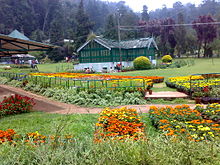
Government Rose Garden
The Government rose garden (formerly known as the Jayalalithaa Rose Garden, Centerary Rose Park and Nootrandu Roja Poonga)[15][16] is the largest rose garden in India.[17] It is situated on the slopes of the Elk Hill in Vijayanagaram of Ooty town in Tamil Nadu, India[18] at an altitude of 2200 meters. Today this garden has one of the largest collection of roses in the country with more than 20,000 varieties of roses of 2,800 cultivars.[19] The collection include Hybrid Tea Roses, Miniature Roses, Polyanthas, Papagena, Floribunda, Ramblers, Yakimour and roses of unusual colours like black and green.
Ooty Botanical Gardens
The 22-acre (89,000 m2) Ooty Botanical Gardens was laid out in 1847[20] and is maintained by the Government of Tamil Nadu. The Botanical Garden is lush, green, and well-maintained. A flower show along with an exhibition of rare plant species is held every May. The Gardens have around a thousand species, both exotic and indigenous, of plants, shrubs, ferns, trees, herbal and bonsai plants.[21] The garden has a 20-million-year-old fossilized tree.[22][23]
Ooty Lake
Ooty lake covers an area of 65 acres.[24] The Boat house established alongside the lake, which offers boating facilities to tourists, is a major tourist attraction in Ooty. It was constructed in 1824 by John Sullivan, the first collector of Ooty. The lake was formed by damming the mountain streams flowing down Ooty valley.[24] The lake is set among groves of Eucalyptus trees with a railway line line running along one bank. During summer season in May, boat races and boat pageantry are organised for two days at the lake.[25][26]
Stone House
Stone House is the first bungalow constructed in Ooty. It was built by John Sullivan and was called as Kal Bangala by the tribals (Kal means stone in Tamil). John Sullivan started building Stonehouse in 1822, acquiring land from the Todas at one rupee an acre.[27] Today, it is the official residence for the principal of the Government Arts College, Ooty.[28][29][30]
Toda huts
There are a few Toda huts on the hills above Botanical Garden, where Todas still dwell. There are other Toda settlements in the area, notably Kandal Mund near Old Ooty. Although many Toda have abandoned their traditional distinctive huts for concrete houses,[31] a movement is now afoot to build tradition barrel-vaulted huts and during the last decade forty new huts have been built and many Toda sacred dairies renovated.[32]
Ooty Mountain Railway
The Nilgiri Mountain Railway was built by the British in 1908,[33] and was initially operated by the Madras Railway Company. The railway still relies on its fleet of steam locomotives.[34] NMR comes under the jurisdiction of the newly formed Salem Division. In July 2005, UNESCO added the Nilgiri Mountain Railway as an extension to the World Heritage Site of Darjeeling Himalayan Railway, the site then became known as "Mountain Railways of India."[35] after it satisfied the necessary criteria, thus forcing abandonment of the modernisation plans. For the past several years diesel locomotives have taken over from steam on the section between Coonoor and Udhagamandalam. Local people and tourists have led a demand for steam locos to once again haul this section.[34]
St. Stephen's Church
St. Stephen's Church is located on the road to Mysore in Ooty,[36] in the state of Tamil Nadu, India. It is one of the oldest churches in the Nilgiris district.[25][37] The church dates back to the 19th century. Stephen Rumbold Lushington, the then Governor of Madras, who keenly felt the need for a cathedral exclusively for the British, in Ooty, laid the foundation for the church on April 23, 1829, to coincide with the birthday of King George IV. St. Stephen's Church was consecrated by John Matthias Turner, Bishop of Calcutta, on November 5, 1830. It was thrown open to public communion on Easter Sunday April 3, 1831. It came under the Church of South India in 1947.[25] The architect incharge was John James Underwood, Captain, Madras Regiment.[38]
Wax World, Ooty
A wax museum that houses life-size look-alike wax statues of personalities of Indian history, culture and heritage housed in a 142-year-old bungalow.
Ooty Golf Course
Ooty Golf Course is located in Ooty town.[39][40] The golf course is set at an altitude of 7600 feet.[41] It is owned by the Gymkhana club in Ooty. The course extends over 193.56 acres[42] and comprises 18 holes.[41]
Tribal Museum
The Tribal Museum is part of the campus of Tribal Research Centre which is in Muthorai Palada (10 km from Ooty town). It is home to rare artifacts and photographs of tribal groups of Tamil Nadu as well as Andaman and Nicobar Islands and anthropological and archaeological primitive human culture and heritage. The Tribal Museum also displays houses belongs to Toda, Kota, Paniya, Kurumba and Kanikaran.
Tourist spots around Ooty
Ooty is situated in the Nilgiri Biosphere Reserve. Many of the forested areas and water bodies are off-limits to most visitors to protect this fragile ecosystem. Some areas of the Biosphere Reserve have been earmarked for tourism development, and steps are being undertaken to open these areas to visitors whilst conserving the area. Much of Ooty has already been damaged by rampant commercialization as a result of tourism. Some of the most prominent tourist spots around Ooty are as follows:
- Doddabetta Peak: It is the highest peak (2,623 m) in the Nilgiris, about 10 km from Ooty. It lies at the junction of the Western and Eastern Ghats and offers beautiful vistas of the Nilgiri Hill ranges. It is surrounded by dense sholas. One can have a panoramic view of the landscape through the TTDC telescope. TTDC restaurant caters the needs of tourists.
- Pykara is a river located 19 km from Ooty.[43] The Pykara is considered very sacred by the Todas.[44] The Pykara river rises at Mukurthi peak. It passes through hilly tract, generally keeping to North and turns to West after reaching the Plateau's edge.[44] The river has a dam and power plant. The river flows through a series of cascades; and the last two falls of 55 meters and 61 meters are known as Pykara falls.[44] The falls are approximately 6 km from the bridge on the main road. There is a forest rest House at Pykara. A boat house by the Pykara falls and Dam is added attractions to the tourists.Pykara boasts of well protected fenced Sholas, Toda settlements, undistributed grassy meadows and also a good wildlife habitat. The Pykara Dam, Pykara falls and the reservoir attracts many tourists.[43] Being one of the oldest plants in south India, the Pykara station still functions, generating about 60 megawatts. The first unit of 6.65 MW was commissioned in October 1932.[45]
- Pine forest: Situated between Ooty and Thalakunda, this tourist destination was once featured in a song sequence in the Tamil movie "Dheena". It is a small downhill region where pine trees are arranged in an orderly fashion.
- Wenlock Downs: This is a grassland area typical of the original bioscape of the Nilgiris. It has gently undulating hills and is often compared with areas in the British isles such as the Yorkshire Dales. This is a popular film shooting area, particularly two areas situated approximately six and nine miles (14 km) out of Ooty on the main Ooty to Pykara road (also known as Mysore Road). These locations are accordingly named "Sixth Mile" and "Ninth Mile".
- Kamaraj Sagar Dam (also known as Sandynalla reservoir)[46] is located at a distance of 10 km from the Ooty bus stand.[47][48] It is a picnic spot and a film shooting spot on the slopes of the Wenlock Downs.[49] The various tourist activities the dam include fishing and studying nature and environment.[50]
- Mudumalai National Park, now also declared a Tiger Reserve, lies on the northwestern side of the Nilgiri Hills (Blue Mountains), in Nilgiri District.[51] Mudumalai, which means 'first hills’, is one of the first wildlife sanctuaries established in India.[52] The sanctuary is divided into 5 ranges - Masinagudi, Thepakadu, Mudumalai, Kargudi and Nellakota. Here one can often spot herds of endangered Indian elephants, vulnerable Gaur, and Chital. The sanctuary is a haven for Bengal Tigers[53] and Indian Leopards and other threatened species.[54] There are at least 266 species of birds in the sanctuary, including critically endangered species like the Indian White-rumped Vulture and the long-billed vulture.[55] The Western Ghats, Nilgiri Sub-Cluster (6,000 km2 (2,300 sq mi)), including all of Mudumalai National Park, is under consideration by the UNESCO World Heritage Committee for selection as a World Heritage Site.[56]
- Mukurthi National Park is a 78.46 km² protected area located in the south-eastern corner of the Nilgiris Plateau west of Ooty. The park was created to protect its Keystone species, the Nilgiri Tahr.[57] The park is a part of Nilgiri Biosphere Reserve, India's first International Biosphere Reserve. The Western Ghats, Nilgiri Sub-Cluster (6,000+ km²), including all of Mukurthi National Park, is under consideration by the UNESCO World Heritage Committee for selection as a World Heritage Site.[56]
- Needle hill viewpoint is situated between Coodalore and Pykara.
- Parsons Valley Reservoir: This is the primary water source for the town and is mainly in a reserved forest and is thus largely off-limits to visitors.
- Emerald Lake: This lake is near the town of the same name. There is a viewpoint near the dam. The rest of the area is mainly in a reserved forest and is largely off-limits to visitors.
- Avalanche Lake: Adjacent to Emerald Lake, this picturesque lake is mainly situated in a reserved forest and is largely off-limits to visitors
- Porthimund Lake: This is mostly in a reserved forest and is largely off-limits to visitors. Shooting of the blockbuster Tamil movie Roja was done here.
- Upper Bhavani: This lake is in the Mukurthi National Park and largely off-limits to visitors.
Image gallery
-

View of Ooty from Doddabetta peak
-

Tea plantations near Ooty
-

Ketti Valley
-

Pykara Lake near Ooty
-

Pykara falls near Ooty
-

Pine forest on the way to Pykara falls
-

Pine forest in fog
-

Elephant at Mudumalai National Park
-

Emerald Lake
Adventure sports in Ooty
The diverse landscape of Ooty offers an opportunity to explore number of adventure sports and recreational activities, including hang gliding. Located around 20 km from Ooty, Kalahatty in the mountain ranges of Nilgiris is a world-class site for hang gliding. This adventure sport involves hanging suspended by a harness from a large type of kite that is known as hang glider. Kalahatty has a launch area that can be reached by a jeep. From March to May, hang gliding training courses are organised in Ooty.
Eco-friendliness
A lot of action have been carried out in the past few years to maintain the precarious ecosystem that is present in this part of the region. Plastic carry bags have been banned for years now. Residents as well as shopkeepers prefer to use only recycled paper or cloth bags for normal use.[58] But still proper actions are not performed to maintain Nilgiris a plastic Free zone[59]
See also
- Government Rose Garden, Ooty
- Government Botanical Gardens, Udagamandalam
- Ooty Lake
- Ooty Golf Course
- Stone House, Ooty
- Ooty Radio Telescope
- Mariamman temple, Ooty
- St. Stephen's Church, Ooty
- List of schools in The Nilgiris District
- List of colleges in The Nilgiris District
References
- ^ "About Municipality". municipality.tn.gov.in. http://municipality.tn.gov.in/ooty/abt-muni.htm. Retrieved 2008-02-15.
- ^ "Ooty: In the Lap of the Nilgiris". batchmates.com. http://www.batchmates.com/bmtimes/content.aspx?contentId=1471. Retrieved 2008-02-15.
- ^ a b c "History". ooty.net. http://www.ooty.net/history.html. Retrieved 2008-02-15.
- ^ Price, Sir Frederick (1908). Ootacamund, A History. Madras Govt. Press. pp. 14–15.
- ^ "Ooty History". ooty.ind.in. http://www.ooty.ind.in/ooty_history.php. Retrieved 2008-02-15.
- ^ a b c "Ooty History". evoire.com. http://evoire.com/page/ooty/. Retrieved 2008-02-15.
- ^ "Nilgiri Mountain Railways". nrm.indianrailways.gov.in. http://www.nrm.indianrailways.gov.in/view_section.jsp?lang=0&id=0,6,376. Retrieved 2008-02-15.
- ^ "Monthly mean maximum & minimum temperature and total rainfall based upon 1901-2000 data". imd.gov.in. http://www.imd.gov.in/doc/climateimp.pdf. Retrieved February 15, 2011.
- ^ "Languages in Ooty". mapsofindia.com. http://www.mapsofindia.com/ooty/languages.html. Retrieved 2008-02-16.
- ^ "List of Parliamentary and Assembly Constituencies". Tamil Nadu. Election Commission of India. http://archive.eci.gov.in/se2001/background/S22/TN_ACPC.pdf. Retrieved 2008-10-10.
- ^ "Hill Station in Nilgiri Hills". nilgirihills.in. http://nilgirihills.in/ooty.html. Retrieved 2008-02-16.
- ^ a b c "Romantic Ooty". groundreport.com. http://www.groundreport.com/Lifestyle/Romantic-Ooty_1/2933672. Retrieved 2008-02-16.
- ^ "Helicopter service to Ooty". The Hindu. Aug 02, 2007. http://www.hindu.com/2007/08/02/stories/2007080250530200.htm. Retrieved August 19, 2011.
- ^ "Modern Indian Education System". nilgiris.nic.in. http://nilgiris.nic.in/institutions.htm.
- ^ "Rose Park to be renamed", The Hindu (India), 23 May 2009, http://www.hindu.com/2009/05/23/stories/2009052351540300.htm
- ^ "A rose garden by another name causes confusion", The Hindu (India), 17 May 2008, http://www.hindu.com/2008/05/17/stories/2008051751130300.htm
- ^ "Tourism - Ooty". http://scstsenvis.nic.in/envis/new_page_53.htm. Retrieved 2011-01-22.
- ^ "TAMIL NADU-Rose Garden". http://scstsenvis.nic.in/envis/new_page_53.htm. Retrieved 2011-01-22.
- ^ "World Federation of Rose Societies". http://www.worldrose.org/awards/gardens/centenary.asp. Retrieved 2011-01-21.
- ^ D, Radhakrishnan (09 Jun 2009), "A tribute to creator of Ooty Botanical Garden", The Hindu (India), http://www.hindu.com/2009/06/09/stories/2009060951000200.htm
- ^ "Ooty to host spices show for first time", The Hindu (India), 11 Mar 2010, http://www.hindu.com/2010/03/11/stories/2010031157580500.htm
- ^ "Hills beckon again". Tribuneindia.com. http://www.tribuneindia.com/2003/20030510/windows/main1.htm. Retrieved 2011-01-22.
- ^ "Tamil Nadu - Government Botanical Garden". Scstsenvis.nic.in. http://scstsenvis.nic.in/envis/new_page_53.htm. Retrieved 2011-01-22.
- ^ a b "OOTY LAKE". Nilgiris.tn.gov.in. http://www.nilgiris.tn.gov.in/ooty.htm. Retrieved 2011-02-01.
- ^ a b c "Ooty - Lake". Ooty.com. http://www.ooty.com/travel/lake.htm. Retrieved 2011-02-01.
- ^ "Summer festival in Ooty", The Hindu (India), 27 Mar 2010, http://www.hindu.com/2010/03/27/stories/2010032762260300.htm
- ^ "One Man's Ooty", The Hindu (India), 16 Jan 2005, http://www.hinduonnet.com/thehindu/mag/2005/01/16/stories/2005011600580100.htm
- ^ "Stone House". Ootyindia.in. http://www.ootyindia.in/. Retrieved 2011-02-01.
- ^ Tourist Guide to South India. South India. 2006. pp. 96. ISBN 81-7478-175-7.
- ^ Bradnock, Robert (2000). South India handbook: the travel guide. South India. pp. 153. ISBN 1 900949 81 4.
- ^ Walker, Anthony R. (2004). "The Truth About The Toda". Frontline, The Hindu. http://www.hinduonnet.com/fline/fl2105/stories/20040312000206600.htm.
- ^ Chhabra, Tarun (2005). "How Traditional Ecological Knowledge addresses Global Climate change: the perspective of the Todas - the indigenous people of the Nilgiri hills of South India". Proceedings of the Earth in Transition: First World Conference. http://www.ser.org/iprn/pdf/Tarun_Chhabra.pdf.
- ^ "Mountain Railways of India". UNESCO. http://whc.unesco.org/en/list/944/. Retrieved 1 March 2010.
- ^ a b (in English) Indian Hill Railways: The Nilgiri Mountain Railway (TV). BBC. 21 February 2010. http://www.bbc.co.uk/programmes/b00qzzlm. Retrieved 1 March 2010.
- ^ NMR added as a World Heritage Site
- ^ "Churches". http://www.ooty.com/worship.htm. Retrieved 2011-02-02.
- ^ "Ooty Tourist Attractions". http://www.mapsofindia.com/ooty/tourist-attractions/. Retrieved 2011-02-02.
- ^ "Ootacamund-Heritage Trail". http://www.nilgiris.tn.gov.in/newpages/Heritage%20_Trail.pdf. Retrieved 2011-02-02.
- ^ "Ooty History". Ooty.com. http://www.ooty.com/golf.htm. Retrieved 2011-02-03.
- ^ Duttagupta, Ishani (19 Sep 2010), "Young & wealthy executives transforming the face of golfing", The Economic Times (India), http://economictimes.indiatimes.com/features/sunday-et/life--style/Young--wealthy-executives-transforming-the-face-of-golfing/articleshow/6582117.cms?curpg=2
- ^ a b "Ooty Golf Club". Indiagolfcourses.com. http://www.indiagolfcourses.com/golf-courses-ooty.htm. Retrieved 2011-02-03.
- ^ "Empowered committee inspects golf course on forest land", The Hindu (India), 15 Nov 2008, http://www.hindu.com/2008/11/15/stories/2008111553120300.htm
- ^ a b "Ooty - Pykara Falls". ooty.com. http://www.ooty.com/travel/pykara.htm. Retrieved August 19, 2011.
- ^ a b c "PYKARA". http://nilgiris.nic.in/ooty.htm. Retrieved August 19, 2011.
- ^ T, Ramakrishnan. "Pykara power station a trendsetter". The Hindu. http://www.hinduonnet.com/2006/02/17/stories/2006021717590600.htm. Retrieved August 19, 2011.
- ^ "The Romance of the Nilgiri Trout:Coarse Fishing". Nwea.in. http://nwea.in/conservation/the-romance-of-the-nilgiri-trout.html. Retrieved 2011-02-03.
- ^ "Kamaraj Sagar Dam and Pykara Lake being polluted", The Hindu (India), 06 Nov 2008, http://www.hindu.com/2008/11/06/stories/2008110651190500.htm
- ^ "TOURIST INFORMATION". Nilgiris.tn.gov.in. http://www.nilgiris.tn.gov.in/tourist_info.htm. Retrieved 2011-02-03.
- ^ "Kamraj sagar lake". Ooty-tourism.com. http://ooty-tourism.com/tourist-places.html. Retrieved 2011-02-03.
- ^ "KAMARAJ SAGAR (Sandynallah Reservoir):". Nilgiris.tn.gov.in. http://www.nilgiris.tn.gov.in/ooty.htm. Retrieved 2011-02-03.
- ^ "India Based Neutrino Observatory & conserving the largest wild populations of the Asian elephant". Letter to Chief Minister of Tamil Nadu. rainforestinfo.org. http://www.rainforestinfo.org.au/e/ino.htm. Retrieved 2009-11-03.
- ^ Dogra, IFS, Rakesh Kumar, Wildlife Warden, Plan for Mudumalai Wildlife Sanctuary and National Park (2007-08 to 2016-17) Udhagamandalam, Tamil Nadu Forest Department, Mount Stuart Hill, Udhagamandalam-643 001, Tamil Nadu, India
- ^ Radha Venkatesan. "Big leap for big cat: TN has 37 of them today". The Hindu. http://articles.timesofindia.indiatimes.com/2008-06-09/flora-fauna/27772652_1_mudumalai-elusive-tiger-latest-tiger-census. Retrieved Jun 9, 2008.
- ^ "MUDUMALAI WILDLIFE SANCTUARY & NATIONAL PARK". Wild Biodiversity. TamilNadu Forest Department. http://www.forests.tn.nic.in/WildBiodiversity/np_mnp.html. Retrieved 2009-10-30.
- ^ "Mudumalai Wildlife Sanctuary". Conservation database. Bangalore: Ashoka Trust for Research in Ecology and the Environment Eco-Informatics Center. http://www.ecoinfoindia.org/lldb_mudumalai_ws.php. Retrieved 2009-11-09.
- ^ a b UNESCO, World Heritage sites, Tentative lists, Western Ghats sub cluster, Ooty. retrieved 4/20/2007 World Heritage sites, Tentative lists
- ^ Dogra, Rakesh Kumar (July 7, 2006), Mukurthi National Park Management plan; 2004-2009, The Protected Area part 1.doc (Draft ed.), Udhagamandalam, Tamil Nadu: Wildlife Warden, Mount Stuart Hill,
- ^ "Ban on carry bags". The Hindu (Chennai, India). 2005-02-04. http://www.hindu.com/2005/02/04/stories/2005020401370300.htm.
- ^ "A tourist Spot is orn to Death". http://www.peermade.info/environment/touristdestinationborndeath.
Further reading
- Weeks, Stephen (1979). Decaying splendours: two palaces : reflections in an Indian mirror. University of California: British Broadcasting Corporation. ISBN 9780563175162. http://books.google.co.in/books?id=gTo2AAAAIAAJ&q=Decaying+Splendours;+two+palaces:+reflections+in+an+Indian+mirror&dq=Decaying+Splendours;+two+palaces:+reflections+in+an+Indian+mirror&ct=result. Retrieved August 19, 2011.
External links
- Ooty
- Ooty / Udhagai / Udhagamandalam / Oootacamund Official history and tourism page on www.nilgiris.tn.gov.in. (This site is maintained by the District Administration of the Nilgiris)
Categories:- Nilgiris District
- Tourism in Tamil Nadu
- Hill stations in India
- Ooty


Wikimedia Foundation. 2010.