- West Adams, Los Angeles
-
West Adams, also known as Historic West Adams, is a large district located in the center of Los Angeles, California, southwest of Downtown and west of USC. It is named after Adams Boulevard, the major east-west surface thoroughfare in the district.
Contents
Geography
West Adams is in an area stretching roughly from Figueroa Street on the east to West Boulevard on the west, and from Pico Boulevard on the north to Jefferson Boulevard on the south. From the Santa Monica freeway, exit at Crenshaw Blvd, Arlington Ave, Western Ave, Normandie Ave, Vermont Avenue or Hoover St.[1]
The district includes many smaller neighborhoods: Adams-Normandie, Pico-Union, Angelus Vista, Arlington Heights Arlington Heights, Los Angeles, California and Harvard Heights on the north, Victoria Park, Lafayette Square, and Wellington Square on the west, and Jefferson Park on the south. Its principal thoroughfares are Adams, Jefferson and Washington Boulevards, Western, Vermont and Normandie Avenues, and Hoover and Figueroa Streets. Major sub-districts include North University Park and Kinney Heights and the eastern portion of Mid-City.
ZIP codes for the district are 90007, 90018 and 90019.
History
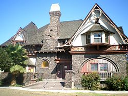 Fitzgerald House
West Adams is one of the oldest neighborhoods in Los Angeles, with most of its buildings erected between 1880 and 1925, including the William Andrews Clark Memorial Library. West Adams was developed by railroad magnate Henry E Huntington and wealthy industrialist Hulett C Merritt of Pasadena. It was once the wealthiest district in the city, with its Victorian mansions and sturdy Craftsman bungalows home to Downtown businessmen and professors and academicians at USC. In the 1990s, three areas of West Adams were designated as Historic Preservation Overlay Zones by the city of Los Angeles, in recognition of their outstanding architectural heritage.
The development of the West Side, Beverly Hills, and Hollywood, beginning in the 1910s, siphoned away much of West Adams' upper-class white population; upper-class blacks began to move in around this time, although the district was off-limits to all but the very wealthiest African-Americans. One symbol of the area's emergence as a center of black wealth at this time is the 1948 headquarters of Golden State Mutual Life, a late-period Art Deco structure at Adams and Western designed by renowned black architect Paul Williams. It housed what is still the nation's largest black-owned insurer. West Adams' transformation into an affluent black area was sped by the Supreme Court's 1948 invalidation of segregationist covenants on property ownership. The area was a favorite among black celebrities in the 1940s and 1950s; notable residents included Hattie McDaniel, Joe Louis, Little Richard and Ray Charles.
Ray Charles' business headquarters, including his RPM studio, is located at 2107 Washington Boulevard. The intersection of Washington Boulevard and Westmoreland Boulevard, at the studio, is named "Ray Charles Square" in his honor.
In the 1950s, the construction of the Harbor Freeway destroyed many large homes on the east side of West Adams, while the 1960's construction of the Santa Monica Freeway totally obliterated Berkeley Square, which held significant houses designed by Elmer Grey, and bisected Harvard Heights. Both sub-divisions lost many large, beautiful homes.
The 1992 Los Angeles riots largely spared West Adams' historic buildings. Mirroring changes seen throughout Los Angeles, the district's Latino population have been growing. The area's architecture and proximity to USC have brought some upper-middle-class whites as well.[2] Many African-American gays have moved into the neighborhood and it has become the center of black gay life in Los Angeles, even earning the nickname of "the black West Hollywood" or "the black Silver Lake"[3] Many of the neighborhoods are experiencing a renaissance of sorts with their historic homes being restored to their previous elegance.
In total more than 70 sites in West Adams have received recognition as a Los Angeles Historic-Cultural Monument, a California Historical Landmark, or by listing on the National Register of Historic Places.
Recent developments
 Britt House, now home of the LA84 Foundation
The projected 2011 opening of the long-delayed Metro Expo Line (light-rail), from Downtown Los Angeles to Culver City and Santa Monica, will include three stations in West Adams. These stations, all on Exposition Boulevard, are Western/Expo, Vermont/Expo, and Expo Park/USC (at Trousdale). This rail line may bring even greater prominence to the West Adams district.[4]
Demographics
 Pocket park in North University Park along Hoover Blvd.
As of the 2000 census, its population was 48,925. Racial breakdown was as follows: 27.6% white, 20.0% black or African-American, 7.7% Asian or Pacific Islander, 0.8% Native American. There were 38.5% of some other race and 5.4% two or more races. 58.1% of persons of any race were of Hispanic/Latino ethnicity.[citation needed]
Fire service
Los Angeles Fire Department's Station 26 serves the district.[5]
Education
 West Adams Preparatory High School
Public schools
West Adams is in the Los Angeles Unified School District.
As of 2007, according to the Van Buren Place Community Restoration Association, 13 elementary schools, 4 middle schools, 6 non-charter high schools, and 2 charter high schools are located in the boundary of West Adams.[6] Some notable schools include Adams Middle School and West Adams Preparatory High School.[7]
Post-secondary education
Colleges and universities within the district include Mount St. Mary's College's Doheny Campus and Hebrew Union College.
Historic architecture
West Adams is home to one of the largest collections of historic homes west of the Mississippi River. The West Adams area was developed between 1880 and 1925, and contains many diverse architectural styles of the era. Architectural styles seen in West Adams include the Queen Anne, Shingle, Gothic Revival, Transitional Arts and Crafts, American Craftsman/Ultimate Bungalow, Craftsman Bungalow, Colonial Revival, Renaissance Revival, Mediterranean Revival, Spanish Colonial Revival, Mission Revival, Egyptian Revival, Beaux-Arts and Neoclassical styles. West Adams boasts the only existing Greene and Greene house left in Los Angeles. Its historic homes are frequently used as locations for movies and TV shows including CSI, Six Feet Under, The Shield, Monk, Confessions of a Dangerous Mind and Of Mice and Men.
Landmarks
 Forthmann House
 Wm. Andrews Clark Memorial Library
 Doheny Mansion
 St. Vincent de Paul Church
 Art of Living Foundation Los Angeles center
- Automobile Club of Southern California headquarters, 1923 (southwest corner of Adams Boulevard and Figueroa Street)
- Felix Chevrolet (northeast corner of Jefferson Boulevard and Figueroa)
- Mount St. Mary's College, Doheny Campus (Adams just east of Hoover Street)
- John Tracy Clinic (Adams just east of Hoover Street)
- Olympic Village, 1932 Summer Olympics (near intersection of Adams and Hoover)
- St. Vincent de Paul Catholic Roman Catholic church (northwest corner of Adams and Figueroa)
- St. John's Cathedral (southwest corner of Adams and Figueroa)
- University of Southern California
- William Andrews Clark Memorial Library
- Forthmann House - At 1102 W. 28th. St. there is a beautiful Victorian home built in 1880. This home is known as the Forthmann House and was built for the founders of the Los Angeles Soap Co. It is characterized by its mansard-roofed tower.
- Art of Living Foundation Los Angeles Center - At 948 West Adams Blvd, this incredible building was for 100 years the Second Church of Christ Scientists and will now be restored and used as a community center by the foundation.
- John B. Kane Residence (Bonsallo Avenue near 23rd St)
Notable natives and residents
- Charles Winchester Breedlove, Los Angeles City Council member, 1933–45
- Edward L. Doheny, oil tycoon
- Arthur Lee, musician
- Hattie McDaniel, actress
See also
- South Central Los Angeles
- List of Registered Historic Places in Los Angeles
- List of Los Angeles Historic-Cultural Monuments in South Los Angeles
References
- ^ About West Adams - West Adams Heritage Association, Los Angeles
- ^ http://query.nytimes.com/search/article-printpage.html?res=9405EFDA1038F937A35754C0A9629C8B63
- ^ West Adams on the Down Low : Curbed LA
- ^ Phase 1 Construction
- ^ Station 26 LA City Fire: Fire Station 26
- ^ West Adams-Normandie.com
- ^ LAUSD Project: West Adams Preparatory High School
External links
- WAHA West Adams Heritage Association
- KCET West Adams: Life & Times
- Los Angeles Times: Saving Harvard Heights
- Van Buren Place Community Restoration Association
- West Adams Heights/Sugar Hill Neighborhood Association
- Arlington Heights Neighborhood Association
- United Neighborhoods Council
- Restoration of a West Adams Bungalow
- Historic Preservation in Los Angeles
- University Park Family is an online newspaper and social network focused on the neighborhoods around USC, Expo Park and the surrounding areas.
- Leimert Park Beat is a collaborative online community focused on adjacent Leimert Park: The Soul of Los Angeles and the African American cultural center of the city.
South Los Angeles region, Los Angeles Districts and
neighborhoodsBaldwin Hills · Baldwin Village · Baldwin Vista · Canterbury Knolls · Chesterfield Square · Crenshaw · Hyde Park · Jefferson Park · King Estates · Leimert Park · University Park · Vermont Square · Watts · West Adams
Points of
interestSee also Downtown · Eastside/Northeast · Harbor Area · Greater Hollywood · Westlake/Silver Lake/Los Feliz · San Fernando and Crescenta Valleys · South Los Angeles · Westside · WilshireCategories:- Los Angeles Historic Preservation Overlay Zones
- Neighborhoods in Los Angeles, California
- Populated places in California with Hispanic majority populations


Wikimedia Foundation. 2010.