- Normalhöhennull
-
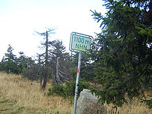 NHN height sign in the Harz mountains of Germany on the Brocken road
Normalhöhennull ("standard elevation zero") or NHN is a standard reference level, the equivalent of sea level, used in Germany to measure height.
In geographical terms, NHN is the reference plane for the normal height of a topographical eminence above sea level used in the 1992 German Mean Height Reference System (Deutsches Haupthöhennetz).[1] The plane is in the shape of a quasi-geoid. The reference height is a geodetic, fixed point on the New Church of St. Alexander at Wallenhorst in the German state of Lower Saxony. The geopotential height of this point was calculated in 1986 as part of the United European Levelling Network (UELN), based on the Amsterdam Ordnance Datum also known as Normalnull ("Standard Zero") or NN, which represents the average level of the North Sea.
Contents
Definition
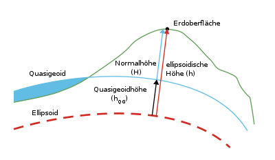 The curved blue line is the quasi-geoid Normalhöhennull reference plane.
Key:Erdoberfläche - earth's surface
Normalhöhe = normal height
ellipsoidische Höhe - ellipsoidal height
Quasigeoidhöhe - quasi-geoid height.The NHN plane is a theoretical reference plane. It is derived by deducting normal heights from the normal plumb line. The difference between the resulting quasi-geoid and the reference ellipsoid is called the height anomaly or quasi-geoid height.
Change-over from NN to NHN
Since 1 January 2000 the whole of Germany has changed its height system over to normal heights based on the datum of the Amsterdam Ordnance Datum, known as the German Mean Height Reference System , DHHN92. At the same time the new NHN is the basis of the United European Levelling Net (UELN), formerly known as the Reseau Européen Unifié de Nivellement or REUN, which standardises the height systems of the European states. Heights in this system are given in metres above NHN or m (NHN).
The NHN was introduced because for heights above Normalnull the actual gravitational field of the earth was not taken into account. As a result there were changes in both the old West German normal orthometric heights (new methods of calculation) and the normal heights of East Germany (referred to the new Normaal Amsterdams Peil datum.
That said, current relief maps often show heights above the old reference planes.
Old East German height system
In the East Germany normal heights used to be referred to as heights above Höhennormal or HN. The 1958 Kronstadt Tide Gauge (Kronstädter Pegel) was used as the datum. The new NHN heights are typically 12–15 cm higher. The maximum deviations in the spirit level points of first order are between 7 and 16 cm.[2]
References
- ^ The German Height Reference System at www.bkg.bund.de. Retrieved on 14 Feb 2010.
- ^ Höhenreferenzsysteme. Bundesamt für Kartographie und Geodäsie. Retrieved on 2009-05-08.
External links
- Description of NHN system (English)
- LVA NRW: DHHN 92 (German)
- BKG: Height reference systems (German)
Categories:

Wikimedia Foundation. 2010.