- National Register of Historic Places listings in Skagit County, Washington
-
List of entries on the National Register of Historic Places in Skagit County, Washington
-
- This National Park Service list is complete through NPS recent listings posted November 10, 2011.[1]
[2] Landmark name[3] Image Date listed Location City or Town Summary 1 Anacortes Public Library October 21, 1977 1305 8th St.
48°30′56″N 122°36′59″W / 48.51556°N 122.61639°WAnacortes Carnegie Libraries of Washington TR (AD) 2 Backus-Marblemount Ranger Station House No. 1009 February 10, 1989 Ranger Station Rd., 1 mi. N of WA 20
48°32′25″N 121°26′56″W / 48.54028°N 121.44889°WMarblemount 3 Backus-Marblemount Ranger Station House No. 1010 February 10, 1989 Ranger Station Rd., 1 mi. N of WA 20
48°32′28″N 121°26′51″W / 48.54111°N 121.4475°WMarblemount 4 Baker River Bridge May 4, 1976 On WA 17A, over Baker River
48°32′28″N 121°44′34″W / 48.54111°N 121.74278°WConcrete Historic Bridges and Tunnels in Washington TR 5 Bethsaida Swedish Evangelical Lutheran Church Parsonage 
December 6, 1990 1754 Chilberg Rd., Pleasant Ridge
48°23′29″N 122°26′32″W / 48.39139°N 122.44222°WLa Conner 6 Burlington Carnegie Library August 3, 1982 901 Fairhaven St.
48°28′33″N 122°19′18″W / 48.47583°N 122.32167°WBurlington Carnegie Libraries of Washington TR 7 California Fruit Store November 5, 1987 909 Third St.
48°31′13″N 122°36′37″W / 48.52028°N 122.61028°WAnacortes 8 Causland Park May 7, 1981 8th St. and M Ave.
48°30′59″N 122°36′55″W / 48.51639°N 122.61528°WAnacortes 9 Deception Pass 
July 16, 1982 Rte. 20
48°24′31″N 122°38′37″W / 48.40861°N 122.64361°WAnacortes Historic Bridges and Tunnels in Washington TR 10 Gilbert's Cabin 
February 10, 1989 Cascade River Rd. W of Gilbert Creek
48°29′19″N 121°5′20″W / 48.48861°N 121.08889°WStehekin 11 Great Northern Depot November 5, 1987 R Ave. & Seventh St.
48°31′2″N 122°36′28″W / 48.51722°N 122.60778°WAnacortes 12 Hidden Lake Peak Lookout July 14, 1987 Mt. Baker Ranger District, Southernmost peak of Hidden Lake Peaks near North Cascades National Park boundary
48°29′44″N 121°12′15″W / 48.49556°N 121.20417°WMarblemount 13 La Conner Historic District 
April 24, 1974 Roughly bounded by 2nd, Morris and Commercial Sts., and Snohomish Channel
48°23′25″N 122°29′46″W / 48.39028°N 122.49611°WLa Conner 14 LA MERCED April 17, 1990 Anacortes Waterfront off Oakes Ave.
48°30′42″N 122°38′45″W / 48.51167°N 122.64583°WAnacortes 15 Lincoln Theater and Commercial Block 
November 5, 1987 301-329 Kincaid St. & 710-740 First St.
48°25′4″N 122°20′14″W / 48.41778°N 122.33722°WMount Vernon 16 Lower Baker River Hydroelectric Power Plant July 17, 1990 Baker River at S end of Shannan Lake
48°32′53″N 121°44′24″W / 48.54806°N 121.74°WConcrete 17 Marine Supply and Hardware Complex November 5, 1987 202-218 Commercial Ave. & 1009 Second St.
48°31′14″N 122°36′42″W / 48.52056°N 122.61167°WAnacortes 18 Birdsey D. Minkler House December 1, 1988 201 S. Main St.
48°31′31″N 122°3′30″W / 48.52528°N 122.05833°WLyman 19 Northern State Hospital December 20, 2010 Roughly bounded by Thompson Dr. to the south, Hemlick Dr. to the east, Hub Dr. to the west, and 1/4 mile south of Mosier Rd. to the north.
48°31′50.03″N 122°12′23.69″W / 48.5305639°N 122.2065806°WSedro-Woolley 20 President Hotel 
December 13, 2010 310 Myrtle St.
48°25′7″N 122°20′17″W / 48.41861°N 122.33806°WMount Vernon 21 Rock Cabin 
February 10, 1989 Fisher Creek Trail S of Diablo Lake
48°34′42″N 120°59′47″W / 48.57833°N 120.99639°WDiablo 22 Semar Block November 5, 1987 501 Q Ave.
48°31′7″N 122°36′33″W / 48.51861°N 122.60917°WAnacortes Demolished in 1999, now a parking lot. 23 Skagit City School July 15, 1977 3.5 mi. S of Mount Vernon on Moore Rd.
48°22′12″N 122°21′59″W / 48.37°N 122.36639°WMount Vernon 24 Swamp-Meadow Cabin East February 10, 1989 Thunder Creek Trail S of Diablo Lake
48°34′44″N 121°1′5″W / 48.57889°N 121.01806°WDiablo 25 Swamp-Meadow Cabin West February 10, 1989 Thunder Creek Trail S of Diablo Lake
48°34′44″N 121°1′5″W / 48.57889°N 121.01806°WDiablo 26 US Post Office-Sedro Woolley Main 
August 7, 1991 111 Woodworth St.
48°30′16″N 122°14′18″W / 48.50444°N 122.23833°WSedro-Woolley 27 W. T. PRESTON (snagboat) 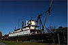
March 16, 1972 Anacortes waterfront, R Ave., at foot of 7th St.
48°30′59″N 122°36′29″W / 48.51639°N 122.60806°WAnacortes 28 Wilson Hotel 
December 15, 2004 804 Commercial Ave.
48°31′3″N 122°36′47″W / 48.5175°N 122.61306°WAnacortes The hotel was designed by Pickles and Sutton of Tacoma, built of bricks from See's Brickyard of Anacortes. The style is Romanesque with masticated stone bases, rounded windows and roman arches. The hotel was added to in 1927. Recently, the Wilson underwent complete restoration & earthquake retrofitting. The work was completed in 2007. The Wilson currently features retail on the main floor and low income housing on the upper floors. References
- ^ "National Register of Historic Places: Weekly List Actions". National Park Service, United States Department of the Interior. Retrieved on November 10, 2011.
- ^ Numbers represent an ordering by significant words. Various colorings, defined here, differentiate National Historic Landmark sites and National Register of Historic Places Districts from other NRHP buildings, structures, sites or objects.
- ^ "National Register Information System". National Register of Historic Places. National Park Service. 2008-04-24. http://nrhp.focus.nps.gov/natreg/docs/All_Data.html.
U.S. National Register of Historic Places Topics Lists by states Alabama • Alaska • Arizona • Arkansas • California • Colorado • Connecticut • Delaware • Florida • Georgia • Hawaii • Idaho • Illinois • Indiana • Iowa • Kansas • Kentucky • Louisiana • Maine • Maryland • Massachusetts • Michigan • Minnesota • Mississippi • Missouri • Montana • Nebraska • Nevada • New Hampshire • New Jersey • New Mexico • New York • North Carolina • North Dakota • Ohio • Oklahoma • Oregon • Pennsylvania • Rhode Island • South Carolina • South Dakota • Tennessee • Texas • Utah • Vermont • Virginia • Washington • West Virginia • Wisconsin • WyomingLists by territories Lists by associated states Other Categories:- National Register of Historic Places in Washington (state) by county
- Skagit County, Washington
- History of Skagit County, Washington
-


Wikimedia Foundation. 2010.