- National Register of Historic Places listings in Ramsey County, Minnesota
-
 Ramsey County
This is a complete list of National Register of Historic Places listings in Ramsey County, Minnesota. There are 111 properties in the county listed on the National Register of Historic Places including three National Historic Landmarks. These properties are recognized by the United States government for their historical significance. A supplementary list includes four additional sites that were formerly listed on the National Register or are listed in adjacent counties.
Ramsey County is a county located in the southeastern part of the U.S. state of Minnesota, bounded in some places by the Mississippi River, by Hennepin County, Anoka County, Washington County, and Dakota County. All of the county seat, Saint Paul is in the county, including Saint Paul's "West Side" neighborhood, which is south of the Mississippi River.
Contents
Current listings
The county's historic places include houses, places of worship, commerce, and education, and community centers and infrastructure. Several districts encompass several structures of related historic significance. Some of the oldest structures in the state are in Ramsey County, representing the earliest of non-native residents in the state. As the northernmost natural port on the Upper Mississippi River, Saint Paul grew, handling both river and rail freight and passenger traffic. Even as Minneapolis (in Hennepin County) eventually surpassed Saint Paul in the volume of commerce, Saint Paul remained relevant as the state capitol and associated government services and employment kept the county growing. Several of the sites are specifically related to the various first-generation immigrant populations that made Ramsey County their new home in America, especially Germans, Czechs, Scandinavians, and Austro-Hungarians, which together comprised the majority of residents in the first century of the county's history.
-
- This National Park Service list is complete through NPS recent listings posted November 10, 2011.[1]
[2] Landmark name [3] Image Date listed Location City or town Summary 1 Arlington Hills Library 
February 10, 1984 1105 Greenbrier Street
44°58′28″N 93°4′16″W / 44.97444°N 93.07111°WSaint Paul 1916 Beaux Arts library building designed by Cameron and Company; a Carnegie Library 2 John M. Armstrong House 
January 27, 1983 225 Eagle Parkway
44°56′28″N 93°6′3″W / 44.94111°N 93.10083°WSaint Paul John Milton Armstrong, son of John Armstrong, Jr. (April 20, 1793 – December 22, 1865) hired architect Edward Payson Bassford to design this side-by-side duplex in 1886 as income-producing residential housing. The red brick house was originally located at 233-235 West Fifth Street, but was moved to its present location on Eagle Parkway in November 2001. 3 Assumption School 
March 26, 1975 68 Exchange Street
44°56′51″N 93°6′0″W / 44.9475°N 93.1°WSaint Paul built in 1864 of local quarter-cut limestone, it is affiliated with the nearby Church of the Assumption[4] 4 Dr. Ward Beebe House 
August 29, 1977 2022 Summit Avenue
44°56′28″N 93°11′9″W / 44.94111°N 93.18583°WSaint Paul also known as the John Leuthold residence, this three-story stucco prairie house was built by Dr. Ward and Bess Beebe and designed by Purcell and Elmslie in 1912 5 Blair Flats 
July 18, 1975 165 Western Avenue
44°56′47″N 93°6′58″W / 44.94639°N 93.11611°WSaint Paul Victorian building designed by Hermann Kretz and William H. Thomas in 1887; construction materials are sandstone-and-brick; has been used as apartments, hotel, and condominiums 6 Bridges No. L-5853 and 92247 

November 6, 1989 Lexington Avenue in Como Park
44°58′42″N 93°8′47″W / 44.97833°N 93.14639°WSaint Paul two side-by side bridges built in 1904 under which the Como-Harriet streetcar ran, connecting to the nearby Twin City Rapid Transit Company station, just to the southeast; Bridge No. 92247 carried traffic on Lexington Avenue over the tracks and Bridge No. L-5853 carried pedestrians; the latter is an example of an early reinforced concrete arch bridge, using the Melan reinforcing system by the William S. Hewett & Company of Minneapolis 7 Joseph Brings House 
January 11, 1983 178 Goodrich Avenue
44°56′15.5″N 93°6′27.5″W / 44.937639°N 93.107639°WSaint Paul also known as the Johan and Maria Magdalena Schilliger House, originally located at 314 Smith Avenue North, the home was built between 1859 and 1862 by John Schilliger,[5] and purchased by Brings in 1863; a cooper, Joseph Brings (1820–1899) was born in Germany and came to Saint Paul in 1857; 83004868 8 Markell and Edward Brooks, Sr. House 
June 15, 2000 176 Mississippi River Boulevard North
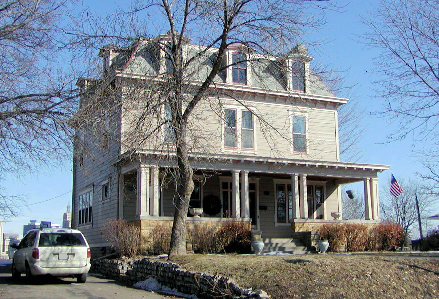
44°56′47″N 93°11′54″W / 44.94639°N 93.19833°WSaint Paul better known as Eastcliff, the Brooks house is a 20-room house overlooking the Mississippi River, that serves as the official residence of the president of the University of Minnesota system 9 Benjamin Brunson House 
May 12, 1975 485 Kenny Rd.
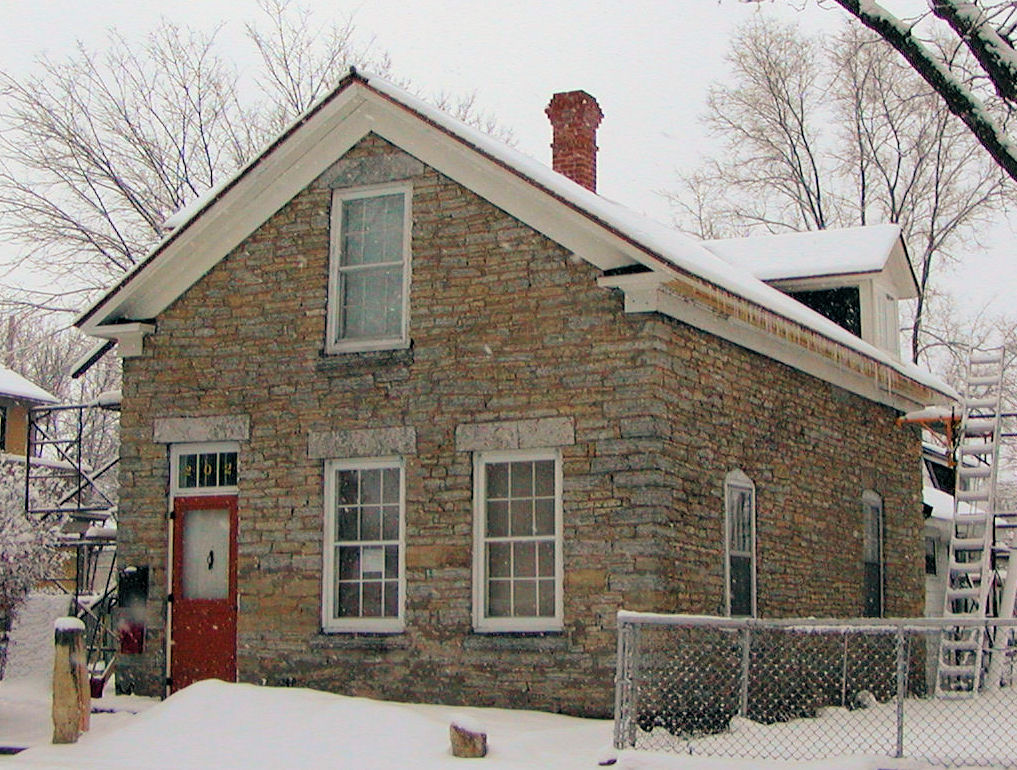
44°57′27″N 93°4′48″W / 44.9575°N 93.08°WSaint Paul one of the oldest houses remaining in Saint Paul, it was built ca. 1856 in the area known as "railroad island," being surrounded by tracks 10 Casiville Bullard House 
January 9, 1997 1282 Folsom Street
44°58′47.7″N 93°7′56.7″W / 44.979917°N 93.132417°WSaint Paul the skilled African-American stonemason and bricklayer, Tennessee-born Casiville Bullard, built this American Foursquare home for himself in 1910 11 Burbank-Livingston-Griggs House 
October 15, 1970 432 Summit Avenue
44°56′28″N 93°7′5″W / 44.94111°N 93.11806°WSaint Paul one of the first examples of Italianate or Tuscan order architecture in Saint Paul, the house was designed by Chicago architect Otis L. Wheelock and built 1862-1865 for James C. Burbank, a wealthy owner of the Minnesota Stage Company, which held a state-wide monopoly controlling 1,600 miles (2,600 km) of stage-lines by 1865[6] 12 Pierce and Walter Butler House 
April 22, 1982 1345-1347 Summit Avenue
44°56′31″N 93°9′25″W / 44.94194°N 93.15694°WSaint Paul a side-by-side duplex, also in the West Summit Avenue Historic District, built in 1900 by Clarence H. Johnston, Sr. for United States Supreme Court justice Pierce Butler and his brother, Walter Butler 13 C.S.P.S. Hall 
February 17, 1977 381-383 Michigan Street
44°56′7″N 93°6′58″W / 44.93528°N 93.11611°WSaint Paul Czech-Slovak Protective Society Hall - a recreation center and meeting house used for social events; important to the cultural preservation of Czech and Slovak immigrants 14 Central Presbyterian Church 
February 10, 1983 500 Cedar Street
44°56′59″N 93°5′46″W / 44.94972°N 93.09611°WSaint Paul a Richardsonian Romanesque church building designed by Warren H. Hayes; built of coarsely carved Lake Superior brownstone[7] 15 Church of St. Agnes-Catholic 
November 19, 1980 548 Lafond Avenue
44°57′35″N 93°7′24″W / 44.95972°N 93.12333°WSaint Paul onion-domed church building designed by George Ries, built 1901-1912 for the German-speaking Austro-Hungarian population of immigrants 16 Church of St. Bernard-Catholic 
February 24, 1983 197 Geranium Avenue West
44°58′34″N 93°6′27″W / 44.97611°N 93.1075°WSaint Paul church building designed by John Jager, built 1905-1914 in the Prairie School and Art Nouveau styles 17 Church of St. Casimir-Catholic 
March 31, 1983 937 Jessamine Avenue East
44°58′30″N 93°3′40″W / 44.975°N 93.06111°WSaint Paul church building built in 1904 in the Beaux Arts style 18 Church of the Assumption-Catholic 

February 10, 1975 51 9th Street West
44°56′51″N 93°5′57″W / 44.9475°N 93.09917°WSaint Paul the oldest existing church in Saint Paul; built in a plain Romanesque style of Lake Superior limestone by a German Catholics, and is said to have been modeled after the Ludwigskirche in Munich 19 Cyrus B. Cobb House 
April 14, 1983 2199 1st Street
45°4′57″N 93°0′27″W / 45.0825°N 93.0075°WWhite Bear Lake a home built ca. 1885-1889, the solid brick house was designed in the Queen Anne architectural style 20 Colorado Street Bridge 
July 5, 1990 East side of South Wabasha Street near Terrace Park
44°56′5″N 93°5′3″W / 44.93472°N 93.08417°WSaint Paul also known as Bridge No. L-8803, a false skew arch bridge, designed in 1888 by Andreas W. Munster; now restricted to pedestrian traffic 21 Commerce Building 
July 3, 2007 8 Fourth Street East
44°56′42″N 93°5′35″W / 44.945°N 93.09306°WSaint Paul 12-story office building built in 1912 is now mixed commercial, office, and residential; 07000645 22 Como Park Conservatory 
November 19, 1974 Como Park
44°58′53″N 93°9′3″W / 44.98139°N 93.15083°WSaint Paul the 1913 conservatory is home to thousands of species of flora 23 William and Catherine Davern Farm House 
October 6, 1983 1173 Davern Street South
44°54′21″N 93°10′22″W / 44.90583°N 93.17278°WSaint Paul Italianate farmhouse built in 1862; William Davern was a member of the first territorial legislature 24 Derham Hall and Our Lady of Victory Chapel, College of Saint Catherine 

October 31, 1985 2004 Randolph Avenue
44°55′32″N 93°11′4″W / 44.92556°N 93.18444°WSaint Paul educational and religious buildings part of the College of St. Catherine 25 Finch, Vanslyck, and McConville Dry Goods Company Building 
February 1, 1982 366 Wacouta Street
44°56′59″N 93°5′13″W / 44.94972°N 93.08694°WSaint Paul classical revival industrial building designed by James E. Denson, built by George Grant Construction Company, 1911, 1923; part of Lowertown Historic District; fronts Smith Park (now Mears Park) 26 First Baptist Church of Saint Paul 
February 24, 1983 499 Wacouta Street
44°57′9″N 93°5′24.5″W / 44.9525°N 93.090139°WSaint Paul when it opened on May 31, 1875, it was the largest and most costly church in Saint Paul, described in the Pioneer Press as "the finest piece of architecture west of Chicago" 27 First National Bank of White Bear 
February 24, 1983 4744 Washington Avenue
45°5′6″N 93°0′30″W / 45.085°N 93.00833°WWhite Bear Lake classical revival bank building designed by Clark E. Van Kirk, unique for the area with a red tile roof; designed in 1921 28 F. Scott Fitzgerald House 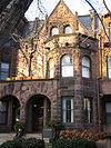
November 11, 1971 599 Summit Avenue
44°56′29.5″N 93°7′30.5″W / 44.941528°N 93.125139°WSaint Paul F. Scott Fitzgerald's home designed by William H. Willcox and Clarence H. Johnston, Sr. 29 Fitzpatrick Building 
July 19, 1990 465-467 Wabasha Street North
44°56′53.5″N 93°5′50″W / 44.948194°N 93.09722°WSaint Paul 1890 Queen Anne style commercial building featuring corner turret and pressed-metal relief 30 Foss House 
May 19, 1983 321 Silver Lake Rd.
45°2′40″N 93°13′2″W / 45.04444°N 93.21722°WNew Brighton a large 1896 Victorian house featuring corner tower, built by Ingebor and Peder Foss in then rural New Brighton 31 Germania Bank Building 
December 6, 1977 6 5th Street West
44°56′44″N 93°5′40″W / 44.94556°N 93.09444°WSaint Paul 1889 Richardson Romanesque office tower built of sandstone designed by J. Walter Stevens 32 Heman Gibbs Farmstead 
April 23, 1975 2097 Larpentuer Avenue
44°59′32″N 93°11′18″W / 44.99222°N 93.18833°WFalcon Heights home of Heman Gibbs and Jane DeBow, first built in 1854; the existing farmhouse includes the small, original cabin 33 Giesen-Hauser House 
May 19, 1983 827 Mound Street
44°57′3″N 93°3′43″W / 44.95083°N 93.06194°WSaint Paul 1891 Queen Anne style sandstone and brick house, designed by Albert Zschoke; also known as Gregory & Nancy Ward Residence 34 S. Edward Hall House 
April 16, 1991 996 Iglehart Avenue
44°56′57.5″N 93°8′32.5″W / 44.949306°N 93.142361°WSaint Paul home of S. Edward Hall (1878–1975), an African American businessman and founder of the Saint Paul chapter of the NAACP; 91000440 35 Hamm Building 
May 30, 1997 408 Saint Peter Street
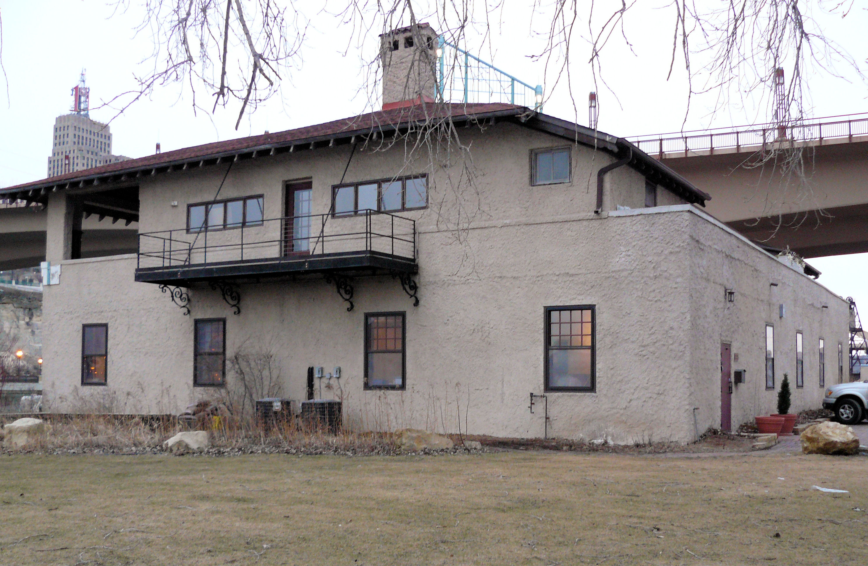
44°56′48″N 93°5′46″W / 44.94667°N 93.09611°WSaint Paul 1915 limestone, terra cotta, and brick commercial building; ornamentation is exceptional 36 Harriet Island Pavilion 
July 10, 1992 75 Water Street
44°56′15″N 93°5′50″W / 44.9375°N 93.09722°WSaint Paul designed by Clarence W. Wigington, the nation's first black municipal architect, and renamed for Wigington after a 2000 restoration[7] 37 Edward and Elizabeth Heimbach House and Carriage House 
October 20, 1983 64 Delos Street West
44°56′02″N 93°5′16″W / 44.93389°N 93.08778°WSaint Paul 1890 high Victorian style two story, 2,556-square-foot (237.5 m2) brick house; the house has an octagonal tower and dome and a detached carriage house 38 Highland Park Tower 
July 17, 1986 1570 Highland Pkwy.
44°55′3.4″N 93°10′0″W / 44.917611°N 93.166667°WSaint Paul octagonally-shaped tower, designed by Clarence W. Wigington — 134 feet (41 m) high and holds 200,000 gallons of water in a steel tank; it is topped with an arched observation deck 39 James J. Hill House 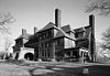
October 15, 1966 240 Summit Avenue
44°56′42″N 93°6′32″W / 44.945°N 93.10889°WSaint Paul with 36,000 square feet (3,344 square meters) of living area, the house is the largest residence in Minnesota 40 James J. Hill's North Oaks Farm, Blacksmith Shop and Machine Shop 
March 6, 1996 Red Barn Road and Hill Farm Circle
45°5′33″N 93°6′30″W / 45.0925°N 93.10833°WNorth Oaks here horses were shod and hinges and wagon wheels were constructed for use on the farm; 98000312 41 James J. Hill's North Oaks Farm, Dairy Building 
May 16, 1997 Red Barn Road and Hill Farm Circle
45°5′33″N 93°6′30″W / 45.0925°N 93.10833°WNorth Oaks in the dairy building, Hill installed a DeLaval separator and barrel churns, which automated the production of butter, using centrifugal force powered by a steam engine; the operation was a forerunner of the modern commercial butter-making industry; 97000441 42 Jacob Hinkel House 
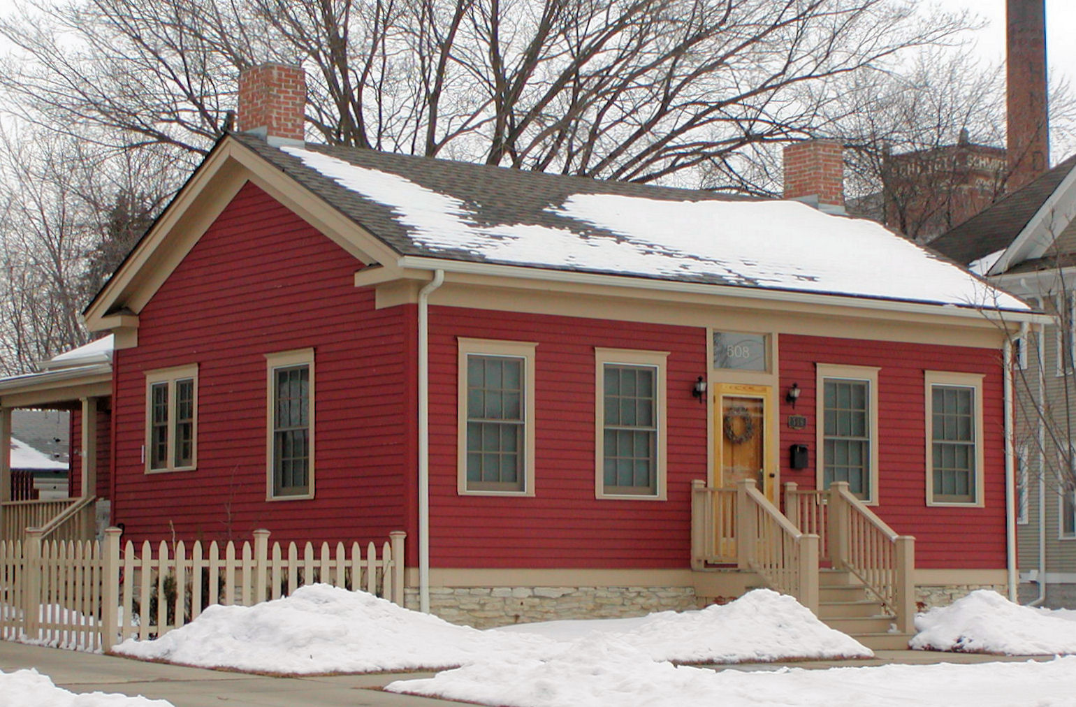
January 3, 1978 531 Brainerd Avenue
44°58′49″N 93°4′42″W / 44.98028°N 93.07833°WSaint Paul built by ice-dealer, Jacob Hinkle in 1873 two miles (3 km) north of downtown, in a rural area in what was New Canada township; the rural route was named after Horace J. Brainerd (1825–1902) an influential property-owner and politician 43 Historic Hill District 
August 13, 1976 Irregular pattern from Pleasant and Grand Avenues to Holly and Marshall Avenues, from Lexington Parkway to 4th and Pleasant Streets
44°56′37″N 93°7′7″W / 44.94361°N 93.11861°WSaint Paul the prestigious high-elevation area northwest of downtown, extending west to Lexington Avenue; known for having a number of historic houses, churches, synagogues, and schools 44 E. H. Hobe House-Solheim 
May 19, 1983 5590 Bald Eagle Boulevard West
45°7′9″N 93°1′33″W / 45.11917°N 93.02583°WWhite Bear Lake Victorian home designed by Minneapolis architect Carl F. Struck in the mid-1890s; home of the, Norwegian consul 45 Holman Field Administration Building 
August 15, 1991 644 Bayfield Street
44°56′31″N 93°3′53″W / 44.94194°N 93.06472°WSaint Paul a Kasota limestone building designed by Clarence Wigington and built in 1939 by WPA employees 46 Intercity Bridge 
November 6, 1989 Ford Pkwy. over Mississippi River
44°55′4.3″N 93°12′4.9″W / 44.917861°N 93.201361°WSaint Paul more commonly known as the Ford Parkway Bridge (and sometimes referred to as the 46th Street Bridge), is a reinforced concrete arch bridge that spans the Mississippi River between Minneapolis and Saint Paul; the bridge is historically significant as one of the largest reinforced concrete bridges ever built in Minnesota. It was built in 1925-1927 by James O. Heyworth, Inc. and was designed by Martin Sigvart Grytbak. 47 Horace Hills Irvine House 
December 16, 1974 1006 Summit Avenue
44°56′28″N 93°8′33″W / 44.94111°N 93.1425°WSaint Paul the official home of the governor of Minnesota, slightly over 16,000 square feet (1,500 m²) in size, it was designed by Minneapolis architect William Channing Whitney for Saint Paul lumberman Horace Hills Irvine and his family; the 20 room English Tudor house has nine bedrooms, eight bathrooms, and nine fireplaces 48 Irvine Park Historic District 
November 27, 1973 Roughly bounded by Irvine Park, West 7th, Walnut, and Sherman
44°56′27″N 93°6′10″W / 44.94083°N 93.10278°WSaint Paul the low-elevation neighborhood just west of downtown Saint Paul that contains a number of historic homes; it was platted by John Irvine and Henry Mower Rice in 1849. At the center of the neighborhood is Irvine Park, a New England-style public square 49 Frank B. Kellogg House 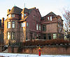
November 6, 1974 633 Fairmount Avenue
44°56′14″N 93°7′36″W / 44.93722°N 93.12667°WSaint Paul home of Frank B. Kellogg, co-author of the Kellogg-Briand Pact[7] 50 Krank Manufacturing Company building 
February 24, 1983 1855 University Avenue West
44°57′25″N 93°10′45″W / 44.95694°N 93.17917°WSaint Paul 1926 industrial building with glazed terra cotta panels featuring brightly carved floral and classical motifs 51 Lauer Flats 
June 5, 1975 226 Western Avenue South
44°56′4″N 93°6′56.3″W / 44.93444°N 93.115639°WSaint Paul 1887 residential townhouses designed by Henry and Charles Lauer in Greek Revival style 52 Olaf Lee House 
February 16, 1984 955 Jessie Street North
44°58′12″N 93°4′40″W / 44.97°N 93.07778°WSaint Paul 1905 house designed by Clarence Johnston, significant for sophisticated Swiss Chalet and craftsman design 53 Lock and Dam No. 2 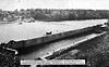
June 13, 2003 Mississippi River North of Lake Street/Marshall Avenue
44°57′14″N 93°12′28″W / 44.95389°N 93.20778°WSaint Paul Although listed in Hennepin County, this site spans the river, placing portions of it in Ramsey County. 54 Lowertown Historic District 
February 21, 1983 Roughly bounded by Kellogg Boulevard, Broadway, 7th and Jackson Streets
44°56′58″N 93°5′16″W / 44.94944°N 93.08778°WSaint Paul originally the lower landing on the Mississippi River, it was the first port of access to the Twin Cities on the river; several warehouse, railroad, banking, and distribution buildings served the entire Upper Midwest from 1880–1920; architects who contributed to the neighborhood include Cass Gilbert, J. Walter Stevens, and Charles Frost 55 David Luckert House 
May 12, 1975 480 Iglehart Street
44°56′57.5″N 93°7′13″W / 44.949306°N 93.12028°WSaint Paul 1858 limestone house; one of the oldest homes in Saint Paul 56 Manhattan Building 
1988 360 Robert Street North
44°56′51″N 93°5′24″W / 44.9475°N 93.09°WSaint Paul Renaissance Revival office and banking building also known as Empire Building; designed by Clarence H. Johnston, Sr., 1889 57 Andrew R. McGill House 
December 31, 1974 2203 Scudder Avenue
44°58′37″N 93°11′31″W / 44.97694°N 93.19194°WSaint Paul Queen Anne style home of Governor Andrew R. McGill (served 1887-1889); designed in 1888 by W. A. Hunt 58 Mendota Road Bridge 
November 6, 1989 Water Street over Pickerel Lake Outlet
44°55′31″N 93°6′41″W / 44.92528°N 93.11139°WSaint Paul historically significant as an example of a small-scale 19th century stone arch highway bridge; the bridge resembles other stone arch bridges built in Minnesota townships during the late 19th century and early 20th century, but its ornamentation is unique 59 Merchants National Bank 
December 19, 1974 366-368 Jackson Street
44°56′54″N 93°5′20″W / 44.94833°N 93.08889°WSaint Paul 1892 financial center, also known as Brooks Building 60 Mickey's Diner 
February 24, 1983 36 7th Street West
44°56′51″N 93°5′52″W / 44.9475°N 93.09778°WSaint Paul a classic Art Deco diner car restaurant; it was prefabricated in New Jersey, shipped to Saint Paul by rail 61 Minnesota Boat Club Boathouse on Raspberry Island 
February 4, 1982 1 Wabasha Street South
44°56′31″N 93°5′29″W / 44.94194°N 93.09139°WSaint Paul home of the Minnesota Boat Club, a rowing club founded in 1870; it is the Minnesota's oldest athletic organization 62 Minnesota Building 
June 10, 2009 46 E. 4th St.
44°56′44.28″N 93°5′31.21″W / 44.9456333°N 93.0920028°WSaint Paul 1929 art deco building 63 Minnesota Historical Society Building 
March 20, 1973 690 Cedar Street
44°57′17″N 93°6′0″W / 44.95472°N 93.1°WSaint Paul 1917 building housed the state's oldest institution, founded in 1849. (The building is now the Minnesota Judicial Center.)[8] 64 Minnesota State Capitol 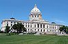
February 23, 1972 Aurora Between Cedar and Park Sts.
44°57′19″N 93°6′6″W / 44.95528°N 93.10167°WSaint Paul designed by Cass Gilbert and modeled after Saint Peter's Basilica in Rome - the unsupported marble dome is the second largest in the world, after Saint Peter's 65 Adolf Muench House 
May 12, 1975 653 5th Street East
44°57′21″N 93°4′23″W / 44.95583°N 93.07306°WSaint Paul 1884 house designed by Emil W. Ulrici overlooks Saint Paul from the bluffs east of downtown 66 Northern Pacific Railway Company Como Shops Historic District 
March 31, 1983 Energy Park Dr. and Bandanna Boulevard
44°58′21″N 93°9′16″W / 44.9725°N 93.15444°WSaint Paul early 20th century railroad buildings of the Northern Pacific Railway, converted to a vacant shopping complex 67 Norway Lutheran Church 
May 12, 1975 2375 Como Avenue West
44°59′3.5″N 93°11′42″W / 44.984306°N 93.195°WSaint Paul erected in 1844 by early Norwegian Lutheran immigrants in Waterford, Wisconsin; moved to Ramsey County in 1904 68 Charles P. Noyes Cottage 
December 12, 1976 4735 Lake Avenue
45°5′7″N 93°0′9″W / 45.08528°N 93.0025°WWhite Bear Lake cottage of Saint Paul pharmacist, Charles P. Noyes 69 O'Donnell Shoe Company Building 
August 20, 2009 509 Sibley Street
44°57′9″N 93°5′29″W / 44.9525°N 93.09139°WSaint Paul Shoe factory built in 1914 by a company that became the largest shoe manufacturer in Minnesota[9] 70 Old Federal Courts Building 
March 24, 1969 109 5th Street West
44°56′44″N 93°5′50″W / 44.94556°N 93.09722°WSaint Paul built in 1902, it originally served as the Federal Court House and Post office for the Upper Midwest 71 Old Main, Macalester College 
August 16, 1977 1600 Grand Avenue
44°56′19″N 93°10′6″W / 44.93861°N 93.16833°WSaint Paul 1886 college building designed by William H. Wilcox 72 Payne Avenue State Bank 
May 15, 2007 965 Payne Avenue
44°58′13.5″N 93°4′26″W / 44.970417°N 93.07389°WSaint Paul also known as the Swedish Bank Building, the 1923 Beaux Arts bank served Scandinavian, German, Italian, and other European settlers who lived in the area; 07000426 73 Pilgrim Baptist Church 
April 16, 1991 732 Central Avenue West
44°57′10″N 93°7′52″W / 44.95278°N 93.13111°WSaint Paul church building that houses the first Black Baptist congregation in Saint Paul; the congregation was founded on November 15, 1866 by Reverend Robert Hickman and a group of escaped slaves from Boone County, Missouri; they were smuggled up the Mississippi River on the steamer War Eagle with the help of Union Soldiers and the Underground Railroad; the current building was built in 1928[4][10] 74 Pioneer and Endicott Buildings 
July 10, 1974 4th and Robert Streets
44°56′50″N 93°5′22″W / 44.94722°N 93.08944°WSaint Paul 1890 Endicott building forms L-shape around 1889 Pioneer building; Endicott building was designed by Cass Gilbert and James Knox Taylor; Pioneer building was designed by Solon Spencer Beman in the Romanesque style; sported the first glass elevator in the nation 75 Ramsey County Poor Farm Barn 
September 22, 1977 2020 White Bear Avenue
45°0′1″N 93°1′27″W / 45.00028°N 93.02417°WMaplewood barn; now used for the Ramsey County Cooperative extension service 76 Alexander Ramsey House 
November 25, 1969 265 Exchange Street South
44°56′30″N 93°6′16″W / 44.94167°N 93.10444°WSaint Paul residence of Alexander Ramsey, who served as the first governor of Minnesota Territory and the second governor of the state of Minnesota 77 Justus Ramsey Stone House 
May 6, 1975 252 7th Street West
44°56′33″N 93°6′16.5″W / 44.9425°N 93.104583°WSaint Paul built in 1851; the oldest known house still standing in Saint Paul; it is an example of a Saint Paul residence of a settler of some financial means 78 Rau/Strong House 
June 18, 1975 2 George Street
44°55′46″N 93°5′6″W / 44.92944°N 93.085°WSaint Paul West Side residence built 1884-1886 in the French Second Empire style with mansard roof and hammered quoin blocks 79 Riverside Hangar 
December 27, 2007 690 Bayfield Street, Building 690-01-01
44°56′30″N 93°3′43″W / 44.94167°N 93.06194°WSaint Paul 07001315 80 Riverview Branch Library 
February 10, 1984 1 George Street East
44°55′48″N 93°5′5″W / 44.93°N 93.08472°WSaint Paul 1916 Carnegie Library designed by Charles A. Hausler in Saint Paul's West Side neighborhood 81 Robert Street Bridge 
November 6, 1989 Robert Street over Mississippi River
44°56′38″N 93°5′14.6″W / 44.94389°N 93.087389°WSaint Paul a reinforced concrete multiple-arch bridge that spans the Mississippi River in downtown Saint Paul; the bridge is notable for its complex design that was required to accommodate river traffic, the St. Paul Union Pacific Vertical-lift Rail Bridge crossing underneath it at an angle, and roadways on the downtown side of Saint Paul; the bridge is also notable for a monumental reinforced concrete rainbow arch 82 Rochat-Louise-Sauerwein Block 
November 19, 1980 261-277 7th Street West
44°56′33″N 93°6′20″W / 44.9425°N 93.10556°WSaint Paul the Sauerwein, Louise, and Rochat buildings comprise one of the few remaining intact Victorian commercial blocks in the city; built 1885-1895 by Castner, Hermann Kretz, and Edward Payson Bassford 83 Otto W. Rohland Building 
January 6, 1983 455–459 Old Fort Road (West 7th Street)
44°56′17″N 93°6′41″W / 44.93806°N 93.11139°WSaint Paul Rohland immigrated from Germany in 1867; this Victorian shop/residential building was built in 1891 and served as Rohland's grocery store and meat market into the 1950s; one source says the market was at 461 Old Fort Road; 83004865 84 Saint Agatha's Conservatory of Music and Arts 
May 25, 1989 26 Exchange Street East
44°56′58″N 93°5′48″W / 44.94944°N 93.09667°WSaint Paul Minnesota's first fine arts school, established by Ellen Ireland, Eliza Ireland, and Ellen Howard;[11] also known as the Exchange Building, this 1908-1910 building was designed by John H. Wheeler; one source says it was a convent 85 Saint Anthony Park Branch Library 
February 10, 1984 2245 Como Avenue West
44°58′52″N 93°11′37″W / 44.98111°N 93.19361°WSaint Paul a Carnegie library built in 1917, the branch circulated 265,776 items in 2005 86 Saint Joseph's Academy 
June 5, 1975 355 Marshall Avenue
44°56′57″N 93°6′54″W / 44.94917°N 93.115°WSaint Paul in 1863 the institution was moved to this location, the oldest Catholic school building in Minnesota; construction is of local yellow limestone built in Italianate style 87 Saint Matthew's School 
November 8, 1984 7 Robie Street West
44°55′51″N 93°5′8″W / 44.93083°N 93.08556°WSaint Paul 1902 school designed by John F. Fisher located on Saint Paul's West Side; it originally served German immigrants and now serves the local Hispanic community 88 Saint Paul Cathedral 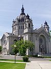
June 28, 1974 Summit Avenue at Selby Avenue
44°56′49″N 93°6′32″W / 44.94694°N 93.10889°WSaint Paul a Roman Catholic cathedral in Saint Paul; it is the cathedral of the Archdiocese of Saint Paul and Minneapolis 89 Saint Paul City Hall and Ramsey County Courthouse 
February 11, 1983 15 Kellogg Boulevard West
44°56′39″N 93°5′37″W / 44.94417°N 93.09361°WSaint Paul a twenty-story Art Deco skyscraper built during the Great Depression 90 Saint Paul, Minneapolis, & Manitoba Railway Company Shops Historic District 
December 21, 1987 Jackson Street and Pennsylvania Avenue
44°57′45″N 93°5′47″W / 44.9625°N 93.09639°WSaint Paul 1882 limestone maintenance building served the Saint Paul, Minneapolis, & Manitoba Railway, and then the Great Northern Railway 91 Saint Paul Municipal Grain Terminal 
July 21, 2004 266 Old Shepard Rd.
44°56′20″N 93°6′0″W / 44.93889°N 93.1°WSaint Paul built between 1927 and 1931 as part of the Equity Cooperative Exchange and is a remnant of Saint Paul's early history as a Mississippi River port city 92 Saint Paul Public Library/James J. Hill Reference Library 
September 11, 1975 80-90 4th Street West
44°56′38″N 93°5′48″W / 44.94389°N 93.09667°WSaint Paul James J. Hill, the Empire Builder's civic legacy is the library in downtown Saint Paul 93 Saint Paul Seminary Historic District 
March 11, 1986 2260 Summit Avenue
44°56′26″N 93°11′44″W / 44.94056°N 93.19556°WSaint Paul now part of the University of Saint Thomas, the first six buildings were built and endowed by the Methodist millionaire, James J. Hill, who gave the school to the Archdiocese of Saint Paul and Minneapolis to honor his Catholic wife, Mary Mehegan Hill; 86003818 94 Saint Paul Union Depot 
December 18, 1974 214 4th Street East
44°56′52″N 93°5′10″W / 44.94778°N 93.08611°WSaint Paul the main train station in the city of Saint Paul until passenger rail service in the region was restructured in the 1960s and 1970s 95 Saint Paul Women's City Club 
March 19, 1982 305 Saint Peter Street
44°56′38″N 93°5′40″W / 44.94389°N 93.09444°WSaint Paul 1931 Art Deco Moderne-style Mankato limestone clubhouse provided a dining room, assembly rooms, dressing rooms, and bedrooms for members and guests; when this building was built, the club had over 1000 members with the goal of providing a "center for organized work and for social and intellectual intercourse;" architect was Magnus Jemne (1882–1964); the building was sold to the Minnesota Museum of Art in 1972 and now houses an architectural firm[12] 96 Salvation Army Women's Home and Hospital 
February 10, 1983 1471 Como Avenue West
44°58′41″N 93°9′46″W / 44.97806°N 93.16278°WSaint Paul 1912 brick Tudor Revival style building designed by Clarence H. Johnston, Sr.; was home for unwed mothers and their children until 1971; now its focus is on young women with behavioral or emotional issues 97 Charles W. Schneider House 
February 16, 1984 1750 Ames Place East
44°58′16″N 93°1′36″W / 44.97111°N 93.02667°WSaint Paul built 1890; 84001677 98 Schornstein Grocery and Saloon 
August 21, 1984 707 Wilson Avenue East and 223 Bates Avenue North
44°57′12″N 93°3′59″W / 44.95333°N 93.06639°WSaint Paul built in 1884 for $5,000 in the French Second Empire style, this Dayton's Bluff business was designed by architect August F. Gauger (1852–1929)[5] 99 Seventh Street Improvement Arches 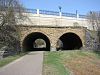
November 6, 1989 East 7th Street over Burlington Northern right-of-way
44°57′24″N 93°4′37″W / 44.95667°N 93.07694°WSaint Paul A double-arched masonry highway bridge that formerly spanned the St. Paul and Duluth Railroad tracks in Saint Paul; they are historically significant for their rarity and the technically demanding nature of their skewed, helicoidal spiral, stone-arch design 100 Sam S. Shubert Theatre and Shubert Building 
August 20, 1984 488—494 Wabasha Street North
44°56′56″N 93°5′51″W / 44.94889°N 93.0975°WSaint Paul Now known as the Fitzgerald Theater and Fitzgerald Condominiums, the 1910 building was modeled after the Maxine Elliott Theatre of New York[1] 101 Frederick Spangenberg House 
June 22, 1976 375 Mt. Curve Boulevard
44°55′49″N 93°11′39″W / 44.93028°N 93.19417°WSaint Paul Built in 1864, it is the oldest limestone farmhouse still standing in Saint Paul; its yellow limestone walls came from banks of the Mississippi River and hauled by stoneboat over snow to the building site 102 Triune Masonic Temple 
November 13, 1980 1898 Iglehart Avenue
44°56′57″N 93°10′50″W / 44.94917°N 93.18056°WSaint Paul 1911 Neo-Classical Revival Masonic temple designed by Henry C. Struchen (1871–1947) 103 United Church Seminary 
October 31, 1985 2481 Como Avenue
44°59′5″N 93°11′47″W / 44.98472°N 93.19639°WSaint Paul conglomerate including 1876 Luther Theological Seminary 104 University Hall-Old Main, Hamline University 
September 22, 1977 1536 Hewitt Avenue
44°57′57″N 93°9′56″W / 44.96583°N 93.16556°WSaint Paul 1884 college building, part of Hamline University 105 Vienna and Earl Apartment Buildings 
April 10, 1984 682-688 Holly Avenue
44°56′35″N 93°7′45″W / 44.94306°N 93.12917°WSaint Paul 1907 Neo-Classical Revival residences, designed by Carl P. Waldon 106 Anthony Waldman House 
January 11, 1983 445 Smith Avenue North
44°56′18″N 93°6′34″W / 44.93833°N 93.10944°WSaint Paul 1864 home of Anthony Waldman a Czech immigrant and his German-born wife[5] 107 Walsh Building 
May 25, 1989 189-191 7th Street East
44°57′3″N 93°5′27″W / 44.95083°N 93.09083°WSaint Paul designed by Edward Payson Bassford, in 1888, the Romanesque building has been used as a residence, school, and manufacturing facility 108 Martin Weber House 
January 11, 1983 202 McBoal Street
44°56′20″N 93°6′31″W / 44.93889°N 93.10861°WSaint Paul 1867 home of Catherin and Martin Weber; built by German immigrant stonemasons, Jacob Amos and Christian Rhinehardt[5] 109 West Summit Avenue Historic District 
May 4, 1993 Summit Avenue between Lexington Parkway and Mississippi River Boulevard
44°56′29″N 93°10′37″W / 44.94139°N 93.17694°WSaint Paul from the Historic Hill District, this district continues west along Summit Avenue to the Mississippi River 110 Woodland Park District 

May 12, 1978 Roughly bounded by Marshall and Selby Avenues, Arundel and Dale Streets
44°56′52″N 93°07′21″W / 44.94778°N 93.1225°WSaint Paul several blocks of historic single-family houses and multi-family dwellings; 78001559 111 Anthony Yoerg, Sr. House 
May 25, 1989 215 Isabel Street West
44°56′0″N 93°5′41″W / 44.933333°N 93.09472°WSaint Paul home of Anthony Yoerg (1816–1896), a Bavarian immigrant who constructed Minnesota's first brewery Related sites
[2] Landmark name Image Date listed Location City or town Summary 1 William Dahl House 
April 1, 1994 508 Jefferson Avenue
44°55′49.5″N 93°7′16.5″W / 44.930417°N 93.12125°WSaint Paul Built by William Dahl and his Irish wife, Catherine Margaret Murphy in 1858, the home was moved from 136 13th Street in 1997; 78001557. The house was apparently de-listed at some point. 2 Salvation Army Headquarters 
Deemed eligible for listing in February 1983 57 10th Street West Saint Paul Later known as the Seton Center, this building was deemed eligible for listing on the NRHP by U.S. Department of the Interior, however owner opposition prevented from being listed. The building was razed in January 1998.[13] 3 Fort Snelling 

October 15, 1966 Pike Island
44°53′32″N 93°09′55″W / 44.89222°N 93.16528°WRamsey County Although most of the fort is located in Hennepin County, Pike Island is part of the fort's property and is in Ramsey County. See also
References
- ^ "National Register of Historic Places: Weekly List Actions". National Park Service, United States Department of the Interior. Retrieved on November 10, 2011.
- ^ a b Numbers represent an ordering by significant words. Various colorings, defined here, differentiate National Historic Landmark sites and National Register of Historic Places Districts from other NRHP buildings, structures, sites or objects.
- ^ "National Register Information System". National Register of Historic Places. National Park Service. . http://nrhp.focus.nps.gov/natreg/docs/All_Data.html.
- ^ a b Nord, Mary Ann (2003). The National Register of Historic Places in Minnesota. Minnesota Historical Society. ISBN 0-87351-448-3.
- ^ a b c d Hess, Jeffrey A.; Paul Clifford Larson. St. Paul's Architecture: A History. University of Minnesota Press.
- ^ "Historic Roadside Development Structures Inventory". MNDOT. 1998. http://www.dot.state.mn.us/tecsup/site/historic/files/iforms/DL-OSA-021.pdf. Retrieved 2007-12-13.[dead link]
- ^ a b c Millett, Larry (2007). AIA Guide to the Twin Cities: The Essential Source on the Architecture of Minneapolis and St. Paul. Minnesota Historical Society Press. pp. 320. ISBN 0-87351-540-4.
- ^ "History of the Minnesota Historical Society". http://www.mnhs.org/about/mnhistory.html. Retrieved 2008-03-24.
- ^ "Preserving a piece of St. Paul's history: Redeveloping the O’Donnell Shoe Factory". Aeon Minnesota. http://www.aeonmn.org/files/aeon/files/fact%20sheets/Ren%20Box%20Site%20History%20-%207-%2009.pdf. Retrieved 2009-10-12.
- ^ "Pilgrim Baptist Church, a first for Black Minnesota!". The African American Registry. 2005. http://www.aaregistry.com/african_american_history/2572/_Pilgrim_Baptist_Church_a_first_for_Black_Minnesota. Retrieved 2007-11-12.[dead link]
- ^ Kunz, Virginia Brainard (1991). Saint Paul - The First 150 Years. The Saint Paul Foundation. ISBN 0-9630690-0-4.
- ^ "St. Paul Phototour". geomyidae. http://www.geomyidae.com/index.php?RollID=pxwestdowntown&FrameID=westdowntown019. Retrieved 2008-03-25.
- ^ Various letters and records, State Historic Preservation Office in the Minnesota History Center.
Further reading
Nord, Mary Ann (2003). The National Register of Historic Places in Minnesota. Minnesota Historical Society. ISBN 0-87351-448-3.
External links
- A list of the above sites, with street addresses and other information, is available at Ramsey County, MN listing of National Register of Historic Places.Com, a private site serving up NRHP information.
U.S. National Register of Historic Places Topics Lists by states Alabama • Alaska • Arizona • Arkansas • California • Colorado • Connecticut • Delaware • Florida • Georgia • Hawaii • Idaho • Illinois • Indiana • Iowa • Kansas • Kentucky • Louisiana • Maine • Maryland • Massachusetts • Michigan • Minnesota • Mississippi • Missouri • Montana • Nebraska • Nevada • New Hampshire • New Jersey • New Mexico • New York • North Carolina • North Dakota • Ohio • Oklahoma • Oregon • Pennsylvania • Rhode Island • South Carolina • South Dakota • Tennessee • Texas • Utah • Vermont • Virginia • Washington • West Virginia • Wisconsin • WyomingLists by territories Lists by associated states Other Categories:- Ramsey County, Minnesota
- National Register of Historic Places in Minnesota by county
- Buildings and structures in Ramsey County, Minnesota
-


Wikimedia Foundation. 2010.