- National Register of Historic Places listings in Kendall County, Texas
-
List of Registered Historic Places in Kendall County, Texas
This is intended to be a complete list of properties and districts listed on the National Register of Historic Places in Kendall County, Texas. The locations of National Register properties and districts (at least for all showing latitude and longitude coordinates below) may be seen in a Google map by clicking on "Map of all coordinates".[1]
-
- This National Park Service list is complete through NPS recent listings posted November 10, 2011.[2]
[3] Landmark name Image Date listed Location City or town Summary 1 Otto Brinkmann House 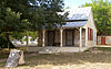
December 12, 1977 602 High St.
29°58′04″N 98°54′32″W / 29.967778°N 98.908889°WComfort Ref. #77001457 2 Comfort Historic District 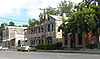
May 29, 1979 Roughly bounded by TX 27. Lindner Ave., Cypress Creek, First St., and Front St.,
29°58′03″N 98°54′40″W / 29.9675°N 98.911111°WComfort Ref. #79002989
Boundary increase on 2004-08-253 Joseph Dienger Building 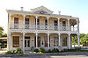
January 19, 1984 106 W. Blanco Rd.
29°47′40″N 98°43′55″W / 29.794444°N 98.731944°WBoerne Ref. #84001901 4 Gazebo for Albert Steves December 23, 2004 105 FM 473, at east portion of property
29°58′05″N 98°52′58″W / 29.968056°N 98.882778°WComfort Ref. #4001171
Gazebo at Haven River Inn
Sculpture by Dionicio Rodriguez5 Herff-Rozelle Farm December 3, 2009 33 Herff Rd.
29°47′16″N 98°43′01″W / 29.787881°N 98.716856°WBoerne Ref. #09000983 6 Hygieostatic Bat Roost 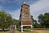
March 28, 1983 FM 473 E of Comfort
29°58′14″N 98°53′10″W / 29.970556°N 98.886111°WComfort Ref. #83003144 7 Kendall County Courthouse and Jail 
February 15, 1980 Public Sq.
29°47′40″N 98°43′50″W / 29.794444°N 98.730556°WBoerne Ref. #80004138 8 Kendall Inn 
June 29, 1976 128 W Blanco Rd
29°47′38″N 98°44′00″W / 29.793889°N 98.733333°WBoerne Ref. #76002045 9 Sisterdale Valley District January 8, 1975 SR 1376
29°58′34″N 98°42′56″W / 29.976111°N 98.715556°WSisterdale Ref. #75001996 10 Treue der Union Monument 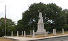
November 29, 1978 High St. between Third and Fourth
29°58′10″N 98°54′49″W / 29.969444°N 98.913611°WComfort Ref. #78002966 See also
References
- ^ The latitude and longitude information provided in this table was derived originally from the National Register Information System, which has been found to be fairly accurate for about 99% of listings. For about 1% of NRIS original coordinates, experience has shown that one or both coordinates are typos or otherwise extremely far off; some corrections may have been made. A more subtle problem causes many locations to be off by up to 150 yards, depending on location in the country: most NRIS coordinates were derived from tracing out latitude and longitudes off of USGS topographical quadrant maps created under the North American Datum of 1927, which differs from the current, highly accurate WGS84 GPS system used by Google maps. Chicago is about right, but NRIS longitudes in Washington are higher by about 4.5 seconds, and are lower by about 2.0 seconds in Maine. Latitudes differ by about 1.0 second in Florida. Some locations in this table may have been corrected to current GPS standards.
- ^ "National Register of Historic Places: Weekly List Actions". National Park Service, United States Department of the Interior. Retrieved on November 10, 2011.
- ^ Numbers represent an ordering by significant words. Various colorings, defined here, differentiate National Historic Landmark sites and National Register of Historic Places Districts from other NRHP buildings, structures, sites or objects.
U.S. National Register of Historic Places Topics Lists by states Alabama • Alaska • Arizona • Arkansas • California • Colorado • Connecticut • Delaware • Florida • Georgia • Hawaii • Idaho • Illinois • Indiana • Iowa • Kansas • Kentucky • Louisiana • Maine • Maryland • Massachusetts • Michigan • Minnesota • Mississippi • Missouri • Montana • Nebraska • Nevada • New Hampshire • New Jersey • New Mexico • New York • North Carolina • North Dakota • Ohio • Oklahoma • Oregon • Pennsylvania • Rhode Island • South Carolina • South Dakota • Tennessee • Texas • Utah • Vermont • Virginia • Washington • West Virginia • Wisconsin • WyomingLists by territories Lists by associated states Other Categories:- Kendall County, Texas
- National Register of Historic Places in Texas
- Buildings and structures in Kendall County, Texas
-


Wikimedia Foundation. 2010.