| [2] |
Landmark name |
Image |
Date listed |
Location |
City or Town |
Summary |
| 1 |
Bay Crest Historic District |
|
01985-09-26 September 26, 1985 |
Beech Avenue, Valley Road, Woodside & Valley Drives
40°54′2″N 73°25′4″W / 40.90056°N 73.41778°W / 40.90056; -73.41778 (Bay Crest Historic District) |
Huntington Bay |
|
| 2 |
M. Baylis House |
|
01985-09-26 September 26, 1985 |
530 Sweet Hollow Road
40°47′24″N 73°25′2″W / 40.79°N 73.41722°W / 40.79; -73.41722 (Baylis, M., House) |
Melville |
|
| 3 |
Beaux Arts Park Historic District |
|
01985-09-26 September 26, 1985 |
Locust Lane, Upper & Lower Drives
40°54′2″N 73°24′31″W / 40.90056°N 73.40861°W / 40.90056; -73.40861 (Beaux Arts Park Historic District) |
Huntington Bay |
|
| 4 |
Bethel AME Church and Manse |
|
01985-09-26 September 26, 1985 |
291 Park Avenue
40°52′41″N 73°25′7″W / 40.87806°N 73.41861°W / 40.87806; -73.41861 (Bethel AME Church and Manse) |
Huntington |
|
| 5 |
Bowes House |
|
01985-09-26 September 26, 1985 |
15 Harbor Hill Drive
40°54′2″N 73°25′28″W / 40.90056°N 73.42444°W / 40.90056; -73.42444 (Bowes House) |
Huntington Bay |
|
| 6 |
George McKesson Brown Estate-Coindre Hall |
 |
01985-09-26 September 26, 1985 |
Brown's Road
40°53′41″N 73°26′13″W / 40.89472°N 73.43694°W / 40.89472; -73.43694 (Brown, George McKesson, Estate--Coindre Hall) |
Huntington Station |
|
| 7 |
Eliphas Buffett House |
|
01985-09-26 September 26, 1985 |
159 West Rogues Path
40°50′16″N 73°26′38″W / 40.83778°N 73.44389°W / 40.83778; -73.44389 (Buffett, Eliphas, House) |
Centerport |
|
| 8 |
Joseph Buffett House |
|
01985-09-26 September 26, 1985 |
169 West Rogues Path
40°50′16″N 73°26′43″W / 40.83778°N 73.44528°W / 40.83778; -73.44528 (Buffett, Joseph, House) |
Cold Spring Harbor |
|
| 9 |
John Bumpstead House |
|
01985-09-26 September 26, 1985 |
473 Woodbury Road
40°50′44″N 73°27′2″W / 40.84556°N 73.45056°W / 40.84556; -73.45056 (Bumpstead, John, House) |
Cold Spring Harbor |
|
| 10 |
Carll S. Burr Mansion |
|
01985-09-26 September 26, 1985 |
304 Burr Road
40°51′4″N 73°17′47″W / 40.85111°N 73.29639°W / 40.85111; -73.29639 (Burr, Carll S., Mansion) |
Commack |
|
| 11 |
Carll Burr, Jr., House |
|
01985-09-26 September 26, 1985 |
293 Burr Road
40°51′4″N 73°18′6″W / 40.85111°N 73.30167°W / 40.85111; -73.30167 (Burr, Carll, Jr., House) |
Commack |
|
| 12 |
Carll House (Dix Hills, New York) |
|
01985-09-26 September 26, 1985 |
380 Deer Park Road
40°48′43″N 73°20′30″W / 40.81194°N 73.34167°W / 40.81194; -73.34167 (Carll House) |
Dix Hills |
|
| 13 |
Carll House (Huntington, New York) |
|
01985-09-26 September 26, 1985 |
79 Wall Street
40°52′22″N 73°25′43″W / 40.87278°N 73.42861°W / 40.87278; -73.42861 (Carll House) |
Huntington |
|
| 14 |
Ezra Carll Homestead |
|
01985-09-26 September 26, 1985 |
49 Melville Road
40°49′40″N 73°23′48″W / 40.82778°N 73.39667°W / 40.82778; -73.39667 (Carll, Ezra, Homestead) |
Huntington Station |
|
| 15 |
Marion Carll Farm |
|
01979-06-26 June 26, 1979 |
475 Commack Road
40°49′33″N 73°17′44″W / 40.82583°N 73.29556°W / 40.82583; -73.29556 (Carll, Marion, Farm) |
Commack |
|
| 16 |
Chichester's Inn |
 |
01985-09-26 September 26, 1985 |
97 Chichester Road
40°49′11″N 73°25′31″W / 40.81972°N 73.42528°W / 40.81972; -73.42528 (Chichester's Inn) |
West Hills |
17th-century inn frequented by Walt Whitman and Theodore Roosevelt at different times. A house today. |
| 17 |
Cold Spring Harbor Fire District Hook and Ladder Company Building |
|
02003-11-15 November 15, 2003 |
Main Street at Elm Place
40°52′10″N 73°27′39″W / 40.86944°N 73.46083°W / 40.86944; -73.46083 (Cold Spring Harbor Fire District Hook and Ladder Company Building) |
Cold Spring Harbor |
|
| 18 |
Cold Spring Harbor Library |
|
01985-09-26 September 26, 1985 |
1 Shore Road
40°52′20″N 73°27′40″W / 40.87222°N 73.46111°W / 40.87222; -73.46111 (Cold Spring Harbor Library) |
Cold Spring Harbor |
|
| 19 |
Coltrane House |
|
02007-06-29 June 29, 2007 |
247 Candlewood Path
40°47′59.29″N 73°19′27.43″W / 40.7998028°N 73.3242861°W / 40.7998028; -73.3242861 (Coltrane House) |
Dix Hills |
|
| 20 |
Commack Methodist Church and Cemetery |
|
01985-09-26 September 26, 1985 |
486 Townline Road
40°50′41″N 73°17′36″W / 40.84472°N 73.29333°W / 40.84472; -73.29333 (Commack Methodist Church and Cemetery) |
Commack |
|
| 21 |
David Conklin House |
|
01985-09-26 September 26, 1985 |
2 High Street
40°51′55″N 73°25′26″W / 40.86528°N 73.42389°W / 40.86528; -73.42389 (Conklin, David, House) |
Huntington |
|
| 22 |
The Crest |
|
02007-10-03 October 3, 2007 |
563 Asharoken Avenue
40°56′22″N 73°23′9″W / 40.93944°N 73.38583°W / 40.93944; -73.38583 (Crest, The) |
Asharoken |
|
| 23 |
Charles Homer Davis House |
|
02006-02-22 February 22, 2006 |
381 West Neck Road
40°53′37″N 73°27′18″W / 40.89361°N 73.455°W / 40.89361; -73.455 (Davis, Charles Homer, House) |
Lloyd Harbor |
|
| 24 |
Delamater-Bevin Mansion |
 |
01985-09-26 September 26, 1985 |
Bevin Lane
40°56′5″N 73°22′43″W / 40.93472°N 73.37861°W / 40.93472; -73.37861 (Delamater-Bevin Mansion) |
Asharoken |
|
| 25 |
Harry E. Donnell House |
 |
01985-09-26 September 26, 1985 |
71 Locust Lane
40°56′2″N 73°23′21″W / 40.93389°N 73.38917°W / 40.93389; -73.38917 (Donnell, Harry E., House) |
Eatons Neck |
|
| 26 |
Arthur Dove-Helen Torr Cottage |
|
02000-01-28 January 28, 2000 |
30 Centershore Road
40°53′16″N 73°22′21″W / 40.88778°N 73.3725°W / 40.88778; -73.3725 (Dove, Arthur--Torr, Helen, Cottage) |
Centerport |
|
| 27 |
Dowden Tannery |
|
01985-09-26 September 26, 1985 |
210 West Rogues Path
40°50′16″N 73°26′58″W / 40.83778°N 73.44944°W / 40.83778; -73.44944 (Dowden Tannery) |
Cold Spring Harbor |
|
| 28 |
East Shore Road Historic District |
|
01985-09-26 September 26, 1985 |
East Shore Road
40°53′27″N 73°25′0″W / 40.89083°N 73.416667°W / 40.89083; -73.416667 (East Shore Road Historic District) |
Halesite |
|
| 29 |
Eatons Neck Light |
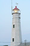 |
01973-04-03 April 3, 1973 |
Eatons Neck Point at Huntington Bay and Long Island Sound off Lighthouse Road
40°57′15″N 73°23′48″W / 40.95417°N 73.39667°W / 40.95417; -73.39667 (Eatons Neck Light) |
Asharoken |
|
| 30 |
John Everit House |
|
01985-09-26 September 26, 1985 |
130 Old Country Road
40°47′33″N 73°25′18″W / 40.7925°N 73.42167°W / 40.7925; -73.42167 (Everit, John, House) |
West Hills |
|
| 31 |
N. J. Felix House |
|
01985-09-26 September 26, 1985 |
235 Asharoken Avenue
40°55′41.2608″N 73°21′46.9116″W / 40.928128°N 73.363031°W / 40.928128; -73.363031 (Felix, N. J., House) |
Asharoken |
|
| 32 |
Marshall Field, III, Estate |
 |
01979-04-30 April 30, 1979 |
Lloyd Harbor Road
40°55′39″N 73°28′18″W / 40.9275°N 73.47167°W / 40.9275; -73.47167 (Field, Marshall, III, Estate) |
Lloyd Harbor |
|
| 33 |
Fort Golgotha and the Old Burial Hill Cemetery |
 |
01981-03-02 March 2, 1981 |
Main Street and Nassau Road
40°52′17″N 73°25′26″W / 40.87139°N 73.42389°W / 40.87139; -73.42389 (Fort Golgotha and the Old Burial Hill Cemetery) |
Huntington |
|
| 34 |
Fort Hill Estate |
|
01988-06-02 June 2, 1988 |
Fort Hill Drive
40°55′4″N 73°29′19″W / 40.91778°N 73.48861°W / 40.91778; -73.48861 (Fort Hill Estate) |
Lloyd Harbor |
|
| 35 |
Charles Geoghegan House |
|
01985-09-26 September 26, 1985 |
9 Harbor Hill Drive
40°54′7″N 73°25′23″W / 40.90194°N 73.42306°W / 40.90194; -73.42306 (Geoghegan, Charles, House) |
Huntington Bay |
|
| 36 |
Gilsey Mansion |
|
01985-09-26 September 26, 1985 |
36 Browns Road
40°53′39″N 73°26′7″W / 40.89417°N 73.43528°W / 40.89417; -73.43528 (Gilsey Mansion) |
Huntington |
|
| 37 |
Goose Hill Road Historic District |
|
01985-09-26 September 26, 1985 |
Goose Hill Road
40°52′40″N 73°27′6″W / 40.87778°N 73.45167°W / 40.87778; -73.45167 (Goose Hill Road Historic District) |
Cold Spring Harbor |
|
| 38 |
John Green House |
|
01985-09-26 September 26, 1985 |
167 East Shore Road
40°53′54″N 73°25′33″W / 40.89833°N 73.42583°W / 40.89833; -73.42583 (Green, John, House) |
Huntington Bay |
|
| 39 |
Halsey Estate-Tallwood |
|
01985-09-26 September 26, 1985 |
Sweet Hollow Road
40°49′32″N 73°25′53″W / 40.82556°N 73.43139°W / 40.82556; -73.43139 (Halsey Estate--Tallwood) |
West Hills |
|
| 40 |
Harbor Road Historic District |
|
01985-09-26 September 26, 1985 |
Harbor Road
40°51′34″N 73°27′43″W / 40.85944°N 73.46194°W / 40.85944; -73.46194 (Harbor Road Historic District) |
Cold Spring Harbor |
|
| 41 |
John Harned House |
|
01985-09-26 September 26, 1985 |
26 Little Neck Road
40°53′16″N 73°21′55″W / 40.88778°N 73.36528°W / 40.88778; -73.36528 (Harned, John, House) |
Centerport |
|
| 42 |
Wallace K. Harrison Estate |
|
01985-09-26 September 26, 1985 |
140 Round Swamp Road
40°48′28″N 73°26′30″W / 40.80778°N 73.44167°W / 40.80778; -73.44167 (Harrison, Wallace K., Estate) |
West Hills |
|
| 43 |
Heckscher Park |
 |
01985-09-26 September 26, 1985 |
Bounded by Madison Street, Sabbath Day Path, Main Street & Prime Avenue
40°52′30″N 73°25′36″W / 40.875°N 73.42667°W / 40.875; -73.42667 (Heckscher Park) |
Huntington |
|
| 44 |
Hewlett House |
|
01985-09-26 September 26, 1985 |
559 Woodbury Road
40°50′13″N 73°27′12″W / 40.83694°N 73.45333°W / 40.83694; -73.45333 (Hewlett House) |
Cold Spring Harbor |
|
| 45 |
House at 200 Bay Avenue |
|
01985-09-26 September 26, 1985 |
200 Bay Avenue
40°54′0″N 73°25′11″W / 40.9°N 73.41972°W / 40.9; -73.41972 (House at 200 Bay Avenue) |
Huntington Bay |
|
| 46 |
House at 244 Park Avenue |
|
01985-09-26 September 26, 1985 |
244 Park Avenue
40°52′47″N 73°25′5″W / 40.87972°N 73.41806°W / 40.87972; -73.41806 (House at 244 Park Avenue) |
Huntington |
|
| 47 |
Ireland-Gardiner Farm |
|
01985-09-26 September 26, 1985 |
863 Lake Road
40°51′46″N 73°22′56″W / 40.86278°N 73.38222°W / 40.86278; -73.38222 (Ireland--Gardiner Farm) |
Greenlawn |
|
| 48 |
Jarvis-Fleet House |
 |
01985-09-26 September 26, 1985 |
138 Cove Road
40°53′58″N 73°23′31″W / 40.89944°N 73.39194°W / 40.89944; -73.39194 (Jarvis--Fleet House) |
Huntington |
|
| 49 |
John P. Kane Mansion |
|
01985-09-26 September 26, 1985 |
37 Kanes Lane
40°53′54″N 73°25′15″W / 40.89833°N 73.42083°W / 40.89833; -73.42083 (Kane, John P., Mansion) |
Huntington Bay |
|
| 50 |
Karpen House |
|
02006-07-26 July 26, 2006 |
3 Harbor Hill Drive
40°53′46″N 73°27′17″W / 40.89611°N 73.45472°W / 40.89611; -73.45472 (Karpen House) |
Lloyd Harbor |
|
| 51 |
A. P. W. Kennan House |
|
01985-11-06 November 6, 1985 |
Sydney Road
40°54′10″N 73°24′40″W / 40.90278°N 73.41111°W / 40.90278; -73.41111 (Kennan, A. P. W., House) |
Huntington Bay |
|
| 52 |
B. Ketchum House |
|
01985-09-26 September 26, 1985 |
237 Middleville Road
40°53′57″N 73°17′51″W / 40.89917°N 73.2975°W / 40.89917; -73.2975 (Ketchum, B., House) |
Fort Salonga |
|
| 53 |
LITTLE JENNIE (Chesapeake Bay bugeye) |
|
01986-05-12 May 12, 1986 |
Centerport Harbor
40°53′36″N 73°22′28″W / 40.89333°N 73.37444°W / 40.89333; -73.37444 (LITTLE JENNIE (Chesapeake Bay bugeye)) |
Centerport |
|
| 54 |
Lloyd Harbor Lighthouse |
 |
01989-05-31 May 31, 1989 |
Entrance to Lloyd Harbor
40°54′39″N 73°25′54″W / 40.91083°N 73.43167°W / 40.91083; -73.43167 (Lloyd Harbor Lighthouse) |
Lloyd Harbor |
|
| 55 |
Joseph Lloyd House |
|
01976-11-07 November 7, 1976 |
NW of Huntington on Lloyd Harbor Road
40°54′51″N 73°28′42″W / 40.91417°N 73.47833°W / 40.91417; -73.47833 (Lloyd, Joseph, House) |
Huntington |
|
| 56 |
Isaac Losee House |
|
01985-09-26 September 26, 1985 |
269 Park Avenue
40°52′44″N 73°25′7″W / 40.87889°N 73.41861°W / 40.87889; -73.41861 (Losee, Isaac, House) |
Huntington |
|
| 57 |
Main Street Historic District |
 |
01985-09-26 September 26, 1985 |
Main Street
40°52′18″N 73°27′21″W / 40.87167°N 73.45583°W / 40.87167; -73.45583 (Main Street Historic District) |
Cold Spring Harbor |
|
| 58 |
Northport Public Library |
 |
01996-12-06 December 6, 1996 |
215 Main Street
40°54′5″N 73°20′38″W / 40.90139°N 73.34389°W / 40.90139; -73.34389 (Northport Public Library) |
Northport |
|
| 59 |
C. A. O'Donohue House |
|
01985-09-26 September 26, 1985 |
158 Shore Road
40°53′59″N 73°25′26″W / 40.89972°N 73.42389°W / 40.89972; -73.42389 (O'Donohue, C. A., House) |
Huntington Bay |
|
| 60 |
John Oakley House |
|
01985-11-06 November 6, 1985 |
Sweet Hollow Road
40°49′14″N 73°25′31″W / 40.82056°N 73.42528°W / 40.82056; -73.42528 (Oakley, John, House) |
West Hills |
|
| 61 |
Oheka |
 |
02004-09-15 September 15, 2004 |
135 West Gate Drive
40°49′40″N 73°26′55″W / 40.82778°N 73.44861°W / 40.82778; -73.44861 (Oheka) |
Cold Springs Hills |
|
| 62 |
Old First Church |
 |
01985-11-06 November 6, 1985 |
126 Main Street
40°52′28″N 73°25′11″W / 40.87444°N 73.41972°W / 40.87444; -73.41972 (Old First Church) |
Huntington |
|
| 63 |
Old Town Green Historic District |
 |
01985-09-26 September 26, 1985 |
Park Avenue
40°52′29″N 73°24′52″W / 40.87472°N 73.41444°W / 40.87472; -73.41444 (Old Town Green Historic District) |
Huntington |
|
| 64 |
Old Town Hall Historic District |
|
01985-09-26 September 26, 1985 |
Main Street & Nassau Road
40°52′17″N 73°25′26″W / 40.87139°N 73.42389°W / 40.87139; -73.42389 (Old Town Hall Historic District) |
Huntington |
|
| 65 |
Potter-Williams House |
|
01985-09-26 September 26, 1985 |
165 Wall Street
40°52′37″N 73°26′18″W / 40.87694°N 73.43833°W / 40.87694; -73.43833 (Potter--Williams House) |
Huntington |
|
| 66 |
Prime House |
 |
01985-09-26 September 26, 1985 |
35 Prime Avenue
40°52′26″N 73°25′23″W / 40.87389°N 73.42306°W / 40.87389; -73.42306 (Prime House) |
Huntington |
|
| 67 |
Prime-Octagon House |
 |
01985-09-26 September 26, 1985 |
41 Prime Avenue
40°52′28″N 73°25′23″W / 40.87444°N 73.42306°W / 40.87444; -73.42306 (Prime--Octagon House) |
Huntington |
|
| 68 |
Michael Remp House |
|
01985-09-26 September 26, 1985 |
42 Godfrey Lane
40°50′48″N 73°21′15″W / 40.84667°N 73.35417°W / 40.84667; -73.35417 (Remp, Michael, House) |
Greenlawn |
|
| 69 |
Rogers House (Huntington) |
|
01985-09-26 September 26, 1985 |
136 Spring Road
40°51′57″N 73°24′56″W / 40.86583°N 73.41556°W / 40.86583; -73.41556 (Rogers House) |
Huntington |
|
| 70 |
John Rogers House (Huntington) |
|
01985-09-26 September 26, 1985 |
627 Half Hollow Road
40°47′18″N 73°20′50″W / 40.78833°N 73.34722°W / 40.78833; -73.34722 (Rogers, John, House) |
Dix Hills |
|
| 71 |
Silas Sammis House |
|
01985-09-26 September 26, 1985 |
302 West Neck Road
40°53′9″N 73°26′23″W / 40.88583°N 73.43972°W / 40.88583; -73.43972 (Sammis, Silas, House) |
Huntington |
|
| 72 |
Seaman Farm |
|
01985-09-26 September 26, 1985 |
1378 Carlls Straight Path
40°48′37″N 73°19′11″W / 40.81028°N 73.31972°W / 40.81028; -73.31972 (Seaman Farm) |
Dix Hills |
|
| 73 |
Shore Road Historic District |
|
01985-09-26 September 26, 1985 |
Shore Road
40°52′22″N 73°27′45″W / 40.87278°N 73.4625°W / 40.87278; -73.4625 (Shore Road Historic District) |
Cold Spring Harbor |
|
| 74 |
Daniel Smith House |
|
01985-09-26 September 26, 1985 |
117 West Shore Road
40°53′13″N 73°25′31″W / 40.88694°N 73.42528°W / 40.88694; -73.42528 (Smith, Daniel, House) |
Huntington |
|
| 75 |
Henry Smith Farmstead |
|
01985-09-26 September 26, 1985 |
900 Park Avenue
40°51′3″N 73°22′48″W / 40.85083°N 73.38°W / 40.85083; -73.38 (Smith, Henry, Farmstead) |
Huntington Station |
|
| 76 |
Jacob Smith House |
|
01985-09-26 September 26, 1985 |
High Hold Drive
40°48′46″N 73°26′16″W / 40.81278°N 73.43778°W / 40.81278; -73.43778 (Smith, Jacob, House) |
West Hills |
|
| 77 |
Suydam House |
 |
01988-10-27 October 27, 1988 |
1 Fort Salonga Road
40°53′9″N 73°22′1″W / 40.88583°N 73.36694°W / 40.88583; -73.36694 (Suydam House) |
Centerport |
|
| 78 |
Sweet Hollow Presbyterian Church Parsonage |
|
01985-09-26 September 26, 1985 |
152 Old Country Road
40°47′33″N 73°25′5″W / 40.7925°N 73.41806°W / 40.7925; -73.41806 (Sweet Hollow Presbyterian Church Parsonage) |
Melville |
|
| 79 |
Titus-Bunce House |
|
01985-09-26 September 26, 1985 |
7 Goose Hill Road
40°52′27″N 73°27′6″W / 40.87417°N 73.45167°W / 40.87417; -73.45167 (Titus--Bunce House) |
Cold Spring Harbor |
|
| 80 |
Henry Townsend House |
|
01985-09-26 September 26, 1985 |
231 West Neck Road
40°55′33″N 73°26′12″W / 40.92583°N 73.43667°W / 40.92583; -73.43667 (Townsend, Henry, House) |
Huntington |
|
| 81 |
US Post Office-Northport |
 |
01989-05-11 May 11, 1989 |
244 Main Street
40°54′2″N 73°20′52″W / 40.90056°N 73.34778°W / 40.90056; -73.34778 (US Post Office--Northport) |
Northport |
|
| 82 |
Charles Van Iderstine Mansion |
|
01985-09-26 September 26, 1985 |
Idle Day Drive
40°54′13″N 73°21′48″W / 40.90361°N 73.36333°W / 40.90361; -73.36333 (Van Iderstine, Charles, Mansion) |
Centerport |
(Try also Charles Iderstine Mansion) |
| 83 |
Van Wyck-Lefferts Tide Mill |
|
01978-12-27 December 27, 1978 |
2 mi. NE of Mill and Southdown Roads
40°53′59″N 73°26′42″W / 40.89972°N 73.445°W / 40.89972; -73.445 (Van Wyck-Lefferts Tide Mill) |
Lloyd Harbor |
|
| 84 |
William K. Vanderbilt Estate-Eagles Nest |
 |
01985-09-26 September 26, 1985 |
Little Neck Road
40°54′18″N 73°22′4″W / 40.905°N 73.36778°W / 40.905; -73.36778 (Vanderbilt, William K., Estate-Eagles Nest) |
Centerport |
|
| 85 |
N. Velzer House and Caretaker's Cottage |
|
01985-09-26 September 26, 1985 |
22 Fort Salonga Road
40°53′10″N 73°21′47″W / 40.88611°N 73.36306°W / 40.88611; -73.36306 (Velzer, N., House and Caretaker's Cottage) |
Centerport |
|
| 86 |
Charles M. Weeks House |
|
01985-09-26 September 26, 1985 |
76 Mill Lane
40°52′45″N 73°25′10″W / 40.87917°N 73.41944°W / 40.87917; -73.41944 (Weeks, Charles M., House) |
Huntington |
|
| 87 |
West Neck Road Historic District |
|
01985-09-26 September 26, 1985 |
West Neck Road
40°52′22″N 73°25′58″W / 40.87278°N 73.43278°W / 40.87278; -73.43278 (West Neck Road Historic District) |
Huntington |
|
| 88 |
Joseph Whitman House |
|
01985-09-26 September 26, 1985 |
365 West Hills Road
40°49′11″N 73°25′21″W / 40.81972°N 73.4225°W / 40.81972; -73.4225 (Whitman, Joseph, House) |
West Hills |
|
| 89 |
Walt Whitman House |
|
01985-09-26 September 26, 1985 |
246 Old Walt Whitman Road
40°49′1″N 73°24′44″W / 40.81694°N 73.41222°W / 40.81694; -73.41222 (Whitman, Walt, House) |
West Hills |
|
| 90 |
Whitman-Place House |
|
01985-09-26 September 26, 1985 |
69 Chichester Road
40°49′11″N 73°25′8″W / 40.81972°N 73.41889°W / 40.81972; -73.41889 (Whitman--Place House) |
West Hills |
|
| 91 |
Wiggins-Rolph House |
|
01985-09-26 September 26, 1985 |
518 Park Avenue
40°52′18″N 73°24′37″W / 40.87167°N 73.41028°W / 40.87167; -73.41028 (Wiggins--Rolph House) |
Huntington |
|
| 92 |
Henry Williams House |
|
01985-09-26 September 26, 1985 |
43 Mill Lane
40°52′43″N 73°26′8″W / 40.87861°N 73.43556°W / 40.87861; -73.43556 (Williams, Henry, House) |
Huntington |
|
| 93 |
Harry Wood House |
|
01985-09-26 September 26, 1985 |
481 West Main Street
40°52′28″N 73°26′27″W / 40.87444°N 73.44083°W / 40.87444; -73.44083 (Wood, Harry, House) |
Huntington |
|
| 94 |
John Wood House |
|
01985-09-26 September 26, 1985 |
121 McKay Road
40°51′10″N 73°25′29″W / 40.85278°N 73.42472°W / 40.85278; -73.42472 (Wood, John, House) |
Huntington Station |
|
| 95 |
William Wooden Wood House |
|
01985-09-26 September 26, 1985 |
90 Preston Street
40°53′20″N 73°25′34″W / 40.88889°N 73.42611°W / 40.88889; -73.42611 (Wood, William Wooden, House) |
Huntington |
|
| 96 |
Charles Woodhull House |
 |
01985-09-26 September 26, 1985 |
70 Main Street
40°52′28″N 73°25′5″W / 40.87444°N 73.41806°W / 40.87444; -73.41806 (Woodhull, Charles, House) |
Huntington |
|


