- National Register of Historic Places listings in Cass County, Iowa
-
 Location of Cass County in Iowa
This is a list of the National Register of Historic Places listings in Cass County, Iowa.
This is intended to be a complete list of the properties and districts on the National Register of Historic Places in Cass County, Iowa, United States. Latitude and longitude coordinates are provided for many National Register properties and districts; these locations may be seen together in a Google map.[1]
There are 10 properties listed on the National Register in the county, including one National Historic Landmark.
-
- This National Park Service list is complete through NPS recent listings posted November 10, 2011.[2]
[3] Landmark name [4] Image Date listed Location City or town Summary 1 American Legion Memorial Building 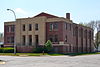
December 12, 2006 201 Poplar St.
41°24′32″N 95°00′50″W / 41.408889°N 95.013889°WAtlantic 2 Atlantic High School 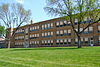
October 24, 2002 1100 Linn St.
41°23′58″N 95°00′25″W / 41.399444°N 95.006944°WAtlantic 3 Cass County Court House 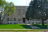
August 28, 2003 5 W. 7th St.
41°24′12″N 95°00′52″W / 41.403333°N 95.014444°WAtlantic 4 Charles F. and Ruth Chase House 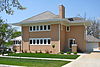
April 15, 1999 110 W. 9th St.
41°24′08″N 95°00′54″W / 41.402222°N 95.015°WAtlantic 5 Chicago, Rock Island & Pacific Railroad Depot 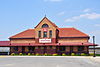
February 23, 1994 Junction of 1st and Chesnut Sts.
41°24′36″N 95°00′46″W / 41.41°N 95.012778°WAtlantic 6 Griswold National Bank February 22, 1979 Main and Cass
41°14′04″N 95°08′34″W / 41.234444°N 95.142778°WGriswold 7 George B. Hitchcock House November 9, 1977 63788 567th Lane
41°18′11″N 95°06′12″W / 41.303056°N 95.103333°WLewis 8 S.F. Martin House 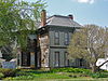
January 12, 1984 419 Poplar St.
41°24′23″N 95°00′09″W / 41.406389°N 95.0025°WAtlantic 9 Job A. and Rebecca E. McWaid House 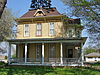
September 9, 1994 702 E. 4th St.
41°24′25″N 95°00′05″W / 41.406944°N 95.001389°WAtlantic 10 Nishnabotna Ferry House January 26, 2001 W. Minnesota St.
41°18′30″N 95°05′38″W / 41.308333°N 95.093889°WLewis See also
References
- ^ The latitude and longitude information provided in this table was derived originally from the National Register Information System, which has been found to be fairly accurate for about 99% of listings. For about 1% of NRIS original coordinates, experience has shown that one or both coordinates are typos or otherwise extremely far off; some corrections may have been made. A more subtle problem causes many locations to be off by up to 150 yards, depending on location in the country: most NRIS coordinates were derived from tracing out latitude and longitudes off of USGS topographical quadrant maps created under the North American Datum of 1927, which differs from the current, highly accurate WGS84 GPS system used by Google maps. Chicago is about right, but NRIS longitudes in Washington are higher by about 4.5 seconds, and are lower by about 2.0 seconds in Maine. Latitudes differ by about 1.0 second in Florida. Some locations in this table may have been corrected to current GPS standards.
- ^ "National Register of Historic Places: Weekly List Actions". National Park Service, United States Department of the Interior. Retrieved on November 10, 2011.
- ^ Numbers represent an ordering by significant words. Various colorings, defined here, differentiate National Historic Landmark sites and National Register of Historic Places Districts from other NRHP buildings, structures, sites or objects.
- ^ "National Register Information System". National Register of Historic Places. National Park Service. . http://nrhp.focus.nps.gov/natreg/docs/All_Data.html.
U.S. National Register of Historic Places Topics Lists by states Alabama • Alaska • Arizona • Arkansas • California • Colorado • Connecticut • Delaware • Florida • Georgia • Hawaii • Idaho • Illinois • Indiana • Iowa • Kansas • Kentucky • Louisiana • Maine • Maryland • Massachusetts • Michigan • Minnesota • Mississippi • Missouri • Montana • Nebraska • Nevada • New Hampshire • New Jersey • New Mexico • New York • North Carolina • North Dakota • Ohio • Oklahoma • Oregon • Pennsylvania • Rhode Island • South Carolina • South Dakota • Tennessee • Texas • Utah • Vermont • Virginia • Washington • West Virginia • Wisconsin • WyomingLists by territories Lists by associated states Other Municipalities and communities of Cass County, Iowa Cities 
Townships Categories:- National Register of Historic Places in Iowa by county
- Cass County, Iowa
- Buildings and structures in Cass County, Iowa
-


Wikimedia Foundation. 2010.