- National Register of Historic Places listings in Buchanan County, Missouri
-
This is a list of properties and historic districts in Buchanan County, Missouri, that are listed on the National Register of Historic Places. .
Contents: Counties in Missouri A–B · C · D–I · J–K · L–N · O–St. · St. Louis · Ste.–Z -
- This National Park Service list is complete through NPS recent listings posted November 10, 2011.[1]
Current listings
Landmark name Image Date listed Location City or Town Summary 1 Buchanan County Courthouse 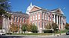
August 21, 1972 Courthouse Sq.
39°46′5″N 94°51′20″W / 39.76806°N 94.85556°WSt. Joseph Originally listed as both courthouse and jail, but jail removed in a 1978 boundary decrease 2 Buchanan County Infirmary January 29, 2009 3500 N. Village Dr.
39°49′1.96″N 94°48′40.85″W / 39.8172111°N 94.8113472°WSt. Joseph 3 Charles A. and Annie Buddy House May 14, 2004 424 S. 9th St.
39°45′49″N 94°50′58″W / 39.76361°N 94.84944°WSt. Joseph 4 Burnside-Sandusky Gothic House January 19, 2005 720 S. 10th St.
39°45′39″N 94°50′53″W / 39.76083°N 94.84806°WSt. Joseph 5 Cathedral Hill Historic District June 15, 2000 North 9th St., Powell St. and North 13th St.
39°46′22″N 94°50′48″W / 39.77278°N 94.84667°WSt. Joseph 6 Central-North Commercial Historic District 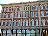
March 8, 1991 Roughly bounded by N. 4th, Main, Francis and Robidoux Sts.
39°46′4″N 94°51′20″W / 39.76778°N 94.85556°WSt. Joseph 7 Central Police Station November 6, 2009 701 Messanie St.
39°45′45.15″N 94°51′6.67″W / 39.7625417°N 94.8518528°WSt. Joseph 8 Century Apartments July 5, 2001 627 N. 25th St.
39°46′16″N 94°49′47″W / 39.77111°N 94.82972°WSt. Joseph 9 Christian Sachau Saloon October 25, 1985 1615 Frederick Ave.
39°46′21″N 94°50′26″W / 39.7725°N 94.84056°WSt. Joseph 10 City Hose Company No. 9 October 25, 1985 2217 Frederick Ave.
39°46′32″N 94°50′0″W / 39.77556°N 94.833333°WSt. Joseph 11 Corby-Forsee Building March 27, 1980 5th and Felix Sts.
39°45′59″N 94°51′15″W / 39.76639°N 94.85417°WSt. Joseph 12 Dewey Avenue-West Rosine Historic District August 1, 2002 Roughly bound by Prospect Ave., Auguste St., Dewey Avenue and West Rosine St.
39°46′42″N 94°51′39″W / 39.77833°N 94.86083°WSt. Joseph 13 Edmond Jacques Eckel House January 31, 1980 515 N. 4th St.
39°46′10″N 94°51′18″W / 39.76944°N 94.855°WSt. Joseph 14 Everett School September 15, 2005 826 S 14th St.
39°45′34″N 94°50′37″W / 39.75944°N 94.84361°WSt. Joseph 15 Enoch Madison Fenton House April 12, 1982 SE of Rushville
39°35′41″N 94°58′30″W / 39.59472°N 94.975°WRushville Demolished.[2] 16 Dr. Jacob Geiger House-Maud Wyeth Painter House March 12, 1986 2501 Frederick Ave.
39°46′37″N 94°49′48″W / 39.77694°N 94.83°WSt. Joseph 17 German-American Bank Building 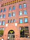
November 24, 1978 624 Felix St.
39°45′59″N 94°51′7″W / 39.76639°N 94.85194°WSt. Joseph 18 Hall Street Historic District July 17, 1979 Roughly bounded by Isadore, Corby, 6th and 9th Sts.
39°46′20″N 94°51′4″W / 39.77222°N 94.85111°WSt. Joseph 19 Harris Addition Historic District January 13, 2003 Roughly bounded by 16th St, Dalton St., 22nd St. and Edmond St.
39°46′4″N 94°50′17″W / 39.76778°N 94.83806°WSt. Joseph 20 Alois Herbert Double House May 29, 2007 620 S. 10th St.
39°45′50″N 94°50′54″W / 39.76389°N 94.84833°WSt. Joseph 21 Jesse James House 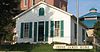
September 4, 1980 12th St. and Mitchell Ave.
39°45′20″N 94°50′43″W / 39.75556°N 94.84528°WSt. Joseph 22 Kelley and Browne Flats August 3, 1989 1208-1216 Frederick Ave.
39°46′12″N 94°50′41″W / 39.77°N 94.84472°WSt. Joseph 23 Kemper Addition Historic District September 20, 2002 Portions of Clay, Union, Kemper and Bon Ton Sts.
39°46′19″N 94°50′11″W / 39.77194°N 94.83639°WSt. Joseph 24 King's Hill Archeological Site 
April 16, 1969 Address Restricted St. Joseph 25 Krug Park Place Historic District August 1, 2002 Roughly bounded by St. Joseph Ave., Myrtle St., Clark St., and Magnolia Ave.
39°47′30″N 94°50′47″W / 39.79167°N 94.84639°WSt. Joseph 26 Lawler Motor Company Building January 8, 2009 1224 Frederick Ave.
39°46′12.31″N 94°50′41.92″W / 39.7700861°N 94.8449778°WSt. Joseph 27 Livestock Exchange Building April 20, 2004 601 Illinois Ave.
39°43′14″N 94°52′10″W / 39.72056°N 94.86944°WSt. Joseph 28 John Sublett Jr. and Caroline Ashton Logan House May 7, 2007 1906 N. 22nd St.
39°47′10″N 94°50′5″W / 39.78611°N 94.83472°WSt. Joseph 29 Maple Grove October 16, 1974 2100 N. 11th St.
39°47′5″N 94°50′46″W / 39.78472°N 94.84611°WSt. Joseph 30 McIntyre-Burri House December 23, 2005 808 N. 24th St.
39°46′35″N 94°49′54″W / 39.77639°N 94.83167°WSt. Joseph 31 Isaac Miller House September 17, 1980 3003 Ashland Ave.
39°47′46″N 94°49′4″W / 39.79611°N 94.81778°WSt. Joseph 32 Miller-Porter-Lacy House September 9, 1982 2912 Frederick Blvd.
39°46′34″N 94°49′14″W / 39.77611°N 94.82056°WSt. Joseph 33 Missouri Theater and Missouri Theater Building 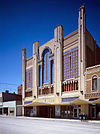
October 11, 1979 112-128 S. 8th St. and 713-721 Edmond St.
39°45′58″N 94°51′2″W / 39.76611°N 94.85056°WSt. Joseph 34 Missouri Valley Trust Company Historic District 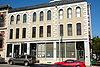
March 4, 1975 Felix and 4th Sts.
39°46′0″N 94°51′21″W / 39.766667°N 94.85583°WSt. Joseph 35 Mount Mora Cemetery 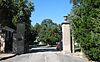
July 19, 2006 824 Mount Mora Rd.
39°46′39″N 94°50′31″W / 39.7775°N 94.84194°WSt. Joseph 36 Museum Hill Historic District March 8, 1991 Roughly bounded by 9th, Francis, 12th, Jules, 15th and Messanie Sts.; also 321 and 323 N. 15th and 1510 Faraon St.
39°45′56″N 94°50′43″W / 39.76556°N 94.84528°WSt. Joseph Second set of addresses represents a boundary increase of August 5, 2009 37 Nelson-Pettis Farmsteads Historic District May 11, 1995 4401 Ajax Rd., 3412 Pettis Rd.
39°43′23″N 94°48′37″W / 39.72306°N 94.81028°WSt. Joseph 38 Patee Town Historic District August 1, 2002 Roughly bounded by Penn St., S. 11th St., Lafayette St. and S. 15th St.
39°45′33″N 94°50′36″W / 39.75917°N 94.84333°WSt. Joseph 39 John Patee House 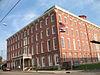
October 15, 1966 12th and Penn Sts.
39°45′21″N 94°50′42″W / 39.75583°N 94.845°WSt. Joseph 40 Pleasant Ridge School May 2, 1985 R.F.D. #4
39°40′57″N 94°49′50″W / 39.6825°N 94.83056°WSt. Joseph 41 Pony Express Stables 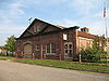
April 3, 1970 914 Penn St.
39°45′22″N 94°50′57″W / 39.75611°N 94.84917°WSt. Joseph Stables at the eastern terminus of the Pony Express 42 John D. Richardson Dry Goods Company 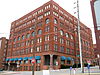
April 12, 1982 300 N. 3rd St.
39°46′7″N 94°51′25″W / 39.76861°N 94.85694°WSt. Joseph 43 Robidoux Hill Historic District August 3, 1989 Roughly bounded by Franklin St., Robidoux St., Fourth St., Louis St., and Fifth St.
39°46′19″N 94°51′17″W / 39.77194°N 94.85472°WSt. Joseph 44 Robidoux Row 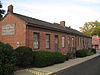
March 7, 1973 219-225 E. Poulin St.
39°46′29″N 94°51′27″W / 39.77472°N 94.8575°WSt. Joseph 45 Robidoux School August 11, 1983 201 S. 10th St.
39°45′24″N 94°50′51″W / 39.75667°N 94.8475°WSt. Joseph 46 St. Joseph City Hall October 25, 1985 Frederick Ave. at Eleventh St.
39°46′7″N 94°50′47″W / 39.76861°N 94.84639°WSt. Joseph 47 St. Joseph Park and Parkway System January 20, 1995 Roughly, along Northwest, Northeast, Corby Grove, Southwest and A Pkwys. and Noyes Blvd. from Krug Park to Hyde Park
39°45′4″N 94°50′25″W / 39.75111°N 94.84028°WSt. Joseph 48 St. Joseph Public Library September 20, 1982 10th and Felix Sts.
39°46′0″N 94°50′53″W / 39.766667°N 94.84806°WSt. Joseph 49 St. Joseph Public Library-Carnegie Branch May 20, 1999 316 Massachusetts St.
39°42′58″N 94°51′58″W / 39.71611°N 94.86611°WSt. Joseph 50 St. Joseph's Commerce and Banking Historic District July 5, 2001 Roughly bounded by 3rd, 91t, Francis, and Edmonds St.
39°45′59″N 94°51′9″W / 39.76639°N 94.8525°WSt. Joseph 51 South Fourth Street Commercial Historic District March 8, 1991 Roughly bounded by S. 3rd, S. 5th, Charles and Messanie Sts.
39°45′50″N 94°51′22″W / 39.76389°N 94.85611°WSt. Joseph 52 Sugar Lake State Park Open Shelter February 28, 1985 Off MO 138
39°32′21″N 95°3′35″W / 39.53917°N 95.05972°WRushville A shelter at Sugar Lake State Park 53 Thompson-Brown-Sandusky House February 10, 1983 207 E. Cliff St.
39°42′33″N 94°51′36″W / 39.70917°N 94.86°WSt. Joseph 54 Virginia Flats May 21, 1992 516-518 and 520-528 N. 10th St.
39°46′14″N 94°50′54″W / 39.77056°N 94.84833°WSt. Joseph 55 Vosteen-Hauck House September 23, 1982 913 N. 2nd St.
39°46′24″N 94°51′28″W / 39.77333°N 94.85778°WSt. Joseph 56 Western Tablet and Stationery Company, Building No. 2 August 16, 2007 1300 S 12th St.
39°45′24″N 94°50′45″W / 39.75667°N 94.84583°WSt. Joseph 57 Wholesale Row September 19, 1977 Bounded by Jules, 3rd, 4th, and Francis Sts.
39°46′4″N 94°51′23″W / 39.76778°N 94.85639°WSt. Joseph 58 Wyeth Flats October 25, 1985 1015-1031 Faraon St.
39°46′9″N 94°50′48″W / 39.76917°N 94.84667°WSt. Joseph See also
References
- ^ "National Register of Historic Places: Weekly List Actions". National Park Service, United States Department of the Interior. Retrieved on November 10, 2011.
- ^ http://www.dnr.mo.gov/shpo/Buchanan.htm
Municipalities and communities of Buchanan County, Missouri Cities De Kalb | Dearborn‡ | Easton | Gower‡ | St. Joseph

Village Townships Unincorporated
communitiesFootnotes ‡This populated place also has portions in an adjacent county or counties
U.S. National Register of Historic Places Topics Lists by states Alabama • Alaska • Arizona • Arkansas • California • Colorado • Connecticut • Delaware • Florida • Georgia • Hawaii • Idaho • Illinois • Indiana • Iowa • Kansas • Kentucky • Louisiana • Maine • Maryland • Massachusetts • Michigan • Minnesota • Mississippi • Missouri • Montana • Nebraska • Nevada • New Hampshire • New Jersey • New Mexico • New York • North Carolina • North Dakota • Ohio • Oklahoma • Oregon • Pennsylvania • Rhode Island • South Carolina • South Dakota • Tennessee • Texas • Utah • Vermont • Virginia • Washington • West Virginia • Wisconsin • WyomingLists by territories Lists by associated states Other Categories:- Buchanan County, Missouri
- National Register of Historic Places in Missouri
-


Wikimedia Foundation. 2010.