- National Register of Historic Places listings in Brookline, Massachusetts
-
This is a list of the National Register of Historic Places listings in Brookline, Massachusetts.
-
- This National Park Service list is complete through NPS recent listings posted November 10, 2011.[1]
Brookline
Landmark name Image Date listed Location Neighborhood Summary 1 1767 Milestones 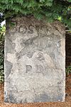
April 7, 1971 Between Boston and Springfield along Old Post Rd.
42°19′48″N 71°5′29″W / 42.33°N 71.09139°WCoolidge Corner (only Brookline marker) Includes markers in Suffolk, Middlesex, Worcester, and Hampden counties. It includes the Milestone listed separately below. 2 Larz Anderson Park Historic District 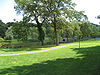
October 17, 1985 Bounded by Goddard and Avon Sts.
42°18′43″N 71°8′10″W / 42.31194°N 71.13611°WLarz Anderson Park Extends into Boston in Suffolk County 3 Arcade Building 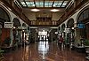
October 17, 1985 314–320A Harvard St.
42°20′35″N 71°7′26″W / 42.34306°N 71.12389°WCoolidge Corner 4 Beacon Street Historic District 
October 17, 1985 Roughly on Beacon St. from Saint Mary's to Ayr Rd.
42°20′23″N 71°7′56″W / 42.33972°N 71.13222°WCoolidge Corner, Washington Square, Cleveland Circle 5 Beaconsfield Terraces Historic District 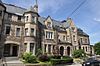
October 17, 1985 11–25, 33–43, and 44–55 Garrison Rd. and 316–326, 332–344, and 350–366 Tappan St.
42°20′14.6″N 71°8′18.3″W / 42.337389°N 71.138417°WBeaconsfield 6 William Ingersoll Bowditch House 
October 17, 1985 9 Toxteth St.
42°20′8″N 71°7′1″W / 42.33556°N 71.11694°WBrookline Village 7 Brandegee Estate October 17, 1985 280 Newton St.
42°18′27.68″N 71°8′45.76″W / 42.3076889°N 71.1460444°WSouth Brookline Extends into Boston in Suffolk County 8 Brookline Town Green Historic District 
June 22, 1980 Chestnut Pl., Fairmont, Dudley, Boylston, Walnut and Warren Sts., Hedge, Codman, and Kennard Rds.
42°19′36″N 71°7′53″W / 42.32667°N 71.13139°WChestnut Hill 9 Brookline Village Commercial District 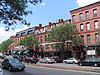
May 22, 1979 Irregular Pattern along Washington St.
42°20′0″N 71°7′16″W / 42.333333°N 71.12111°WBrookline Village 10 Building at 30-34 Station Street 
October 17, 1985 30–34 Station St.
42°19′58.7″N 71°7′0.8″W / 42.332972°N 71.116889°WBrookline Village 11 Lewis Cabot Estate October 17, 1985 514 Warren St.
42°19′21.2″N 71°8′35.02″W / 42.322556°N 71.1430611°WBrookline 12 Candler Cottage 
October 17, 1985 447 Washington St.
42°20′8″N 71°7′31″W / 42.33556°N 71.12528°WCoolidge Corner 13 Chestnut Hill Historic District 
October 17, 1985 Roughly bounded by Middlesex Rd., Reservoir Ln., Denny Rd., Boylston St. and Dunster Rd.
42°19′36″N 71°9′32″W / 42.32667°N 71.15889°WChestnut Hill 14 Isaac Child House October 17, 1985 209 Newton St.
42°18′38″N 71°8′38″W / 42.31056°N 71.14389°WSouth Brookline 15 Timothy Corey House No. 1 
October 17, 1985 808 Washington St.
42°20′29″N 71°8′22″W / 42.34139°N 71.13944°WCorey Farm 16 Timothy Corey House No. 2 
October 17, 1985 786–788 Washington St.
42°20′29″N 71°8′21″W / 42.34139°N 71.13917°WCorey Farm 17 Cottage Farm Historic District March 29, 1978 Roughly bounded by Amory, Dummer, Lenox, Brookline and Beacon Sts.
42°20′51″N 71°6′44″W / 42.3475°N 71.11222°WCottage Farm 18 Cypress-Emerson Historic District 
October 17, 1985 Roughly bounded by Waverly, Emerson, and Cypress Sts.
42°19′58.38″N 71°7′21.02″W / 42.3328833°N 71.1225056°WEmerson Garden 19 Robert S. Davis House 
October 17, 1985 50 Stanton Rd.
42°20′3″N 71°7′37″W / 42.33417°N 71.12694°WBrookline Hills 20 Thomas Aspinwall Davis House 
October 17, 1985 29 Linden Pl.
42°20′6″N 71°7′2.12″W / 42.335°N 71.1172556°WBrookline Village 21 Edward Devotion House 
February 14, 1978 347 Harvard St.
42°20′39″N 71°7′29″W / 42.34417°N 71.12472°WCoolidge Corner 22 Alfred Douglass House October 17, 1985 157 Clyde St.
42°18′41″N 71°8′33″W / 42.31139°N 71.1425°WButtonwood Village 23 The Dutch House 
January 24, 1986 20 Netherlands Rd.
42°20′9.3″N 71°6′44.8″W / 42.335917°N 71.112444°WBrookline Village 24 Gen. Simon Elliot House 
October 17, 1985 61 Heath St.
42°19′29″N 71°8′42″W / 42.32472°N 71.145°WWoodland-Heath 25 Emmett Cottage 
October 17, 1985 217 Freeman St.
42°20′52″N 71°7′13″W / 42.34778°N 71.12028°WBrookline 26 Fernwood October 17, 1985 155 Clyde St.
42°19′14″N 71°8′50″W / 42.32056°N 71.14722°WButtonwood Village 27 Fire Station No. 7 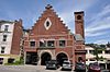
October 17, 1985 665 Washington St.
42°20′19″N 71°8′2″W / 42.33861°N 71.13389°WWashington Square 28 Fisher Hill Historic District 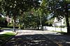
October 17, 1985 Roughly bounded by Clinton and Sumner Rds., Boylston St. and Chestnut Hill Ave.
42°19′52″N 71°8′29″W / 42.33111°N 71.14139°WFisher Hill 29 Fisher Hill Reservoir and Gatehouse 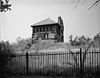
January 18, 1990 Fisher Rd. between Hyslop and Channing Rds.
42°19′45″N 71°8′37″W / 42.32917°N 71.14361°WFisher Hill 30 Dr. Tappan Eustis Francis House 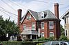
October 17, 1985 35 Davis Ave.
42°19′57″N 71°7′14″W / 42.3325°N 71.12056°WEmerson Garden 31 Peter Fuller Building 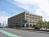
October 17, 1985 808 Commonwealth Ave.
42°21′1″N 71°6′19″W / 42.35028°N 71.10528°WNorth Brookline 32 John Goddard House October 17, 1985 235 Goddard Ave.
42°18′54″N 71°8′11″W / 42.315°N 71.13639°WLarz Anderson Park 33 Graffam Development Historic District 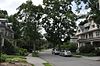
October 17, 1985 Roughly bounded by Abbottsford Rd., Babcock St., Manchester, and Naples Rds.
42°20′56″N 71°7′4″W / 42.34889°N 71.11778°WGraffam-McKay 34 Green Hill Historic District October 17, 1985 Roughly Warren St., Sargent Rd., and Cottage St.
42°19′18″N 71°7′59″W / 42.32167°N 71.13306°WBrookline 35 Hammond Pond Parkway March 18, 2004 Hammond Pond Parkway
42°19′16″N 71°10′20″W / 42.32111°N 71.17222°WChestnut Hill 36 John Harris House and Farm October 17, 1985 284 Newton St.
42°18′16″N 71°8′19″W / 42.30444°N 71.13861°WSouth Brookline Extends into Boston in Suffolk County 37 Charles Heath House 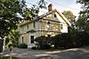
October 17, 1985 12 Heath Hill
42°19′33″N 71°8′34″W / 42.32583°N 71.14278°WWoodland-Heath 38 Ebenezer Heath House 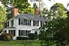
October 17, 1985 30 Heath St.
42°19′31″N 71°8′36″W / 42.32528°N 71.14333°WWoodland-Heath 39 Holyhood Cemetery October 17, 1985 Heath St.
42°19′12″N 71°10′3″W / 42.32°N 71.1675°WChestnut Hill 40 Hotel Adelaide 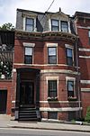
October 17, 1985 13–21 High St.
42°19′51″N 71°7′6″W / 42.33083°N 71.11833°WPill Hill 41 Hotel Kempsford 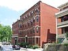
October 17, 1985 72 Walnut St.
42°19′50″N 71°7′8″W / 42.33056°N 71.11889°WPill Hill 42 House at 105 Marion Street 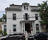
October 17, 1985 105 Marion St.
42°19′51″N 71°7′29″W / 42.33083°N 71.12472°WCoolidge Corner 43 House at 12 Linden Street 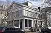
October 17, 1985 12 Linden St.
42°20′4″N 71°7′7″W / 42.33444°N 71.11861°WBrookline Village 44 House at 12 Vernon Street 
October 17, 1985 12 Vernon St.
42°20′18″N 71°7′22″W / 42.33833°N 71.12278°WCoolidge Corner 45 House at 12-16 Corey Road 
October 17, 1985 12–16 Corey Rd.
42°20′17″N 71°8′35″W / 42.33806°N 71.14306°WCorey Farm 46 House at 155 Reservoir 
October 17, 1985 155 Reservoir Rd.
42°19′39.54″N 71°8′58.85″W / 42.32765°N 71.1496806°WPill Hill 47 House at 156 Mason Terrace 
October 17, 1985 156 Mason Terr.
42°20′33″N 71°7′47″W / 42.3425°N 71.12972°WCorey Hill 48 House at 19 Linden Street 
October 17, 1985 19 Linden St.
42°20′3″N 71°7′4″W / 42.33417°N 71.11778°WBrookline Village 49 House at 25 Stanton Road 
October 17, 1985 25 Stanton Rd.
42°20′3″N 71°7′31″W / 42.33417°N 71.12528°WBrookline 50 House at 38-40 Webster Place 
October 17, 1985 38–40 Webster Pl.
42°19′59″N 71°6′57″W / 42.33306°N 71.11583°WBrookline Village 51 House at 4 Perry Street 
October 17, 1985 4 Perry St.
42°20′7″N 71°7′4″W / 42.33528°N 71.11778°WBrookline Village 52 House at 44 Linden Street 
October 17, 1985 44 Linden St.
42°20′5″N 71°7′2″W / 42.33472°N 71.11722°WBrookline Village 53 House at 44 Stanton Road 
October 17, 1985 44 Stanton Rd.
42°20′2″N 71°7′37″W / 42.33389°N 71.12694°WBrookline Hills 54 House at 5 Lincoln Road 
October 17, 1985 5 Lincoln Rd.
42°20′2″N 71°7′33″W / 42.33389°N 71.12583°WBrookline Hills 55 House at 53 Linden Street October 17, 1985 53 Linden St.
42°20′4.22″N 71°6′58.82″W / 42.3345056°N 71.1163389°WBrookline Village 56 House at 83 Penniman Place Possibly demolished October 17, 1985 83 Penniman Pl.
42°19′54″N 71°8′54″W / 42.33167°N 71.14833°WFisher Hill 57 House at 89 Rawson Road and 86 Colburne Crescent 
October 17, 1985 89 Rawson Rd. and 86 Colburne Crescent
42°20′5″N 71°8′2″W / 42.33472°N 71.13389°WAspinwall Hill 58 House at 9 Linden Street 
October 17, 1985 9 Linden St.
42°20′4″N 71°7′8″W / 42.33444°N 71.11889°WBrookline Village 59 Houses at 76-96 Harvard Avenue 
October 17, 1985 76–96 Harvard Ave.
42°20′13″N 71°7′32″W / 42.33694°N 71.12556°WHarvard Avenue 60 Thaddeus Jackson House October 17, 1985 15 Alberta Rd.
42°18′21″N 71°9′16″W / 42.30583°N 71.15444°WSouth Brookline 61 John Fitzgerald Kennedy National Historic Site 
May 26, 1967 83 Beals St.
42°20′53″N 71°7′34″W / 42.34806°N 71.12611°WCoolidge Corner 62 Kilsyth Terrace 
October 17, 1985 15–27 Kilsyth Rd.
42°19′45″N 71°8′39″W / 42.32917°N 71.14417°WCorey Farm 63 Linden Park 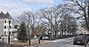
October 17, 1985 Linden Pl. and Linden St.
42°20′37″N 71°7′9″W / 42.34361°N 71.11917°WBrookline Village 64 Linden Square 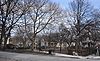
October 17, 1985 Linden Pl.
42°20′6″N 71°7′2″W / 42.335°N 71.11722°WBrookline Village 65 Longwood Historic District September 13, 1978 Roughly bounded by Chapel, St. Marys, Monmouth, and Kent Sts.
42°20′32″N 71°6′40″W / 42.34222°N 71.11111°WLongwood 66 Lynch-O'Gorman House 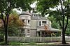
October 17, 1985 41 Mason Terr.
42°20′26″N 71°7′56″W / 42.34056°N 71.13222°WCorey Hill 67 Milestone October 17, 1985 Harvard St. near Marion
42°20′24″N 71°7′17″W / 42.34°N 71.12139°WCoolidge Corner This marker is also contained in the 1767 Milestones, listed above. 68 George R. Minot House 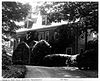
January 7, 1976 71 Sears Rd.
42°19′3″N 71°8′21″W / 42.3175°N 71.13917°WBrookline 69 William Murphy House 
October 17, 1985 97 Sewall Ave.
42°20′30″N 71°7′2″W / 42.34167°N 71.11722°WLongwood 70 Olmsted Park System 
December 8, 1971 Encompassing the Back Bay Fens, Muddy River, Olmsted (Leverett Park), Jamaica Park, Arborway, and Franklin Park
42°20′43″N 71°5′45″W / 42.34528°N 71.09583°WBrookline Extends into Boston, Suffolk County 71 Frederick Law Olmsted House National Historic Site 
October 15, 1966 99 Warren St.
42°19′31″N 71°7′58″W / 42.32528°N 71.13278°WBrookline 72 Rev. John Orrock House October 17, 1985 68 Winchester St.
42°20′33″N 71°7′51″W / 42.3425°N 71.13083°WCorey Hill 73 Paine Estate 
October 17, 1985 325 Heath St.
42°19′21″N 71°9′15″W / 42.3225°N 71.15417°WWoodland-Heath 74 Perkins Estate October 17, 1985 450 Warren St.
42°19′14″N 71°8′39″W / 42.32056°N 71.14417°WBrookline 75 Pill Hill Historic District 
December 16, 1977 Roughly bounded by Boylston St., Pond Ave., Acron, Oakland and Highland Rds.
42°19′41″N 71°7′14″W / 42.32806°N 71.12056°WPill Hill 76 Reservoir Park 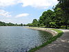
October 17, 1985 Boylston St.
42°19′35″N 71°8′12″W / 42.32639°N 71.13667°WBrookline 77 Richmond Court 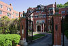
July 18, 1985 1209–1217 Beacon St.
42°20′35″N 71°6′59″W / 42.34306°N 71.11639°WNorth Brookline 78 Ritchie Building 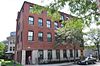
October 17, 1985 112 Cypress St.
42°19′51″N 71°7′34″W / 42.33083°N 71.12611°WBrookline Hills 79 Roughwood 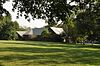
October 17, 1985 400 Heath St.
42°19′13″N 71°9′30″W / 42.32028°N 71.15833°WWoodland-Heath Now the campus of Pine Manor College. 80 Saint Aidan's Church and Rectory 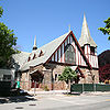
October 17, 1985 207 Freeman and 158 Pleasant Sts.
42°20′51″N 71°7′11″W / 42.3475°N 71.11972°WNorth Brookline 81 St. Mark's Methodist Church 
December 17, 1976 90 Park St.
42°20′21″N 71°7′31″W / 42.33917°N 71.12528°WCoolidge Corner 82 Saint Mary of the Assumption Church, Rectory, School and Convent 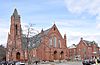
October 17, 1985 67 Harvard St. and 3 and 5 Linden Pl.
42°20′6″N 71°7′11″W / 42.335°N 71.11972°WBrookline Village 83 Saint Paul's Church, Chapel, and Parish House 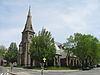
October 17, 1985 15 and 27 Saint Paul St. and 104 Aspinwall Ave.
42°20′14.17″N 71°7′5.73″W / 42.3372694°N 71.1182583°WBrookline Village 84 Saint Paul's Rectory 
October 17, 1985 130 Aspinwall Ave.
42°20′14.31″N 71°7′4.1″W / 42.3373083°N 71.117806°WBrookline Village 85 Sargent's Pond October 17, 1985 Sargent Rd. Brookline 86 Second Unitarian Church 
October 17, 1985 11 Charles St.
42°21′6″N 71°07′46″W / 42.35167°N 71.12944°WCoolidge Corner 87 Eliphalet Spurr House 
October 17, 1985 103 Walnut St.
42°19′52″N 71°7′9″W / 42.33111°N 71.11917°WPill Hill 88 James H. Standish House October 17, 1985 54 Francis St.
42°20′19″N 71°6′57″W / 42.33861°N 71.11583°WBrookline Village 89 Strathmore Road Historic District 
October 17, 1985 Strathmore Rd. and Clinton Path
42°20′10″N 71°8′48″W / 42.33611°N 71.14667°WCleveland Circle 90 Winand Toussaint House 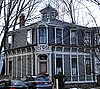
October 17, 1985 203 Aspinwall Ave.
42°20′9″N 71°6′56″W / 42.33583°N 71.11556°WBrookline Village 91 Town Stable 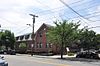
October 17, 1985 237 Cypress St.
42°20′39″N 71°7′29″W / 42.34417°N 71.12472°WPill Hill 92 William F. Tuckerman House 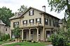
October 17, 1985 63 Harvard Ave.
42°20′12″N 71°7′27″W / 42.33667°N 71.12417°WHarvard Avenue 93 Ginery Twitchell House 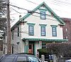
October 17, 1985 17 Kent St.
42°19′59.34″N 71°7′5.08″W / 42.33315°N 71.1180778°WBrookline Village 94 Walnut Hills Cemetery 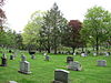
October 17, 1985 Grove St. and Allandale Rd.
42°18′10″N 71°8′50″W / 42.30278°N 71.14722°WSouth Brookline 95 West Roxbury Parkway, Metropolitan Park System of Greater Boston January 19, 2006 West Roxbury Parkway, Bellevue Hill, E. Border Rd., and W. Border Rd.
42°18′10″N 71°9′11″W / 42.30278°N 71.15306°WSouth Brookline Extends into Boston in Suffolk County 96 White Place Historic District 
October 17, 1985 White Pl. between Washington St. and Davis Path
42°19′22″N 71°7′10″W / 42.32278°N 71.11944°WEmerson Garden 97 Benjamin White House 
October 17, 1985 203 Heath St.
42°19′20″N 71°8′58″W / 42.32222°N 71.14944°WWoodland-Heath See also
References
- ^ "National Register of Historic Places: Weekly List Actions". National Park Service, United States Department of the Interior. Retrieved on November 10, 2011.
U.S. National Register of Historic Places Topics Lists by states Alabama • Alaska • Arizona • Arkansas • California • Colorado • Connecticut • Delaware • Florida • Georgia • Hawaii • Idaho • Illinois • Indiana • Iowa • Kansas • Kentucky • Louisiana • Maine • Maryland • Massachusetts • Michigan • Minnesota • Mississippi • Missouri • Montana • Nebraska • Nevada • New Hampshire • New Jersey • New Mexico • New York • North Carolina • North Dakota • Ohio • Oklahoma • Oregon • Pennsylvania • Rhode Island • South Carolina • South Dakota • Tennessee • Texas • Utah • Vermont • Virginia • Washington • West Virginia • Wisconsin • WyomingLists by territories Lists by associated states Other Categories:- Brookline, Massachusetts
- Lists of National Register of Historic Places listings in Massachusetts by populated place
-


Wikimedia Foundation. 2010.