- National Register of Historic Places listings in Brazos County, Texas
-
List of Registered Historic Places in Brazos County, Texas
This is intended to be a complete list of properties and districts listed on the National Register of Historic Places in Brazos County, Texas. The locations of National Register properties and districts (at least for all showing latitude and longitude coordinates below) may be seen in a Google map by clicking on "Map of all coordinates".[1]
-
- This National Park Service list is complete through NPS recent listings posted November 10, 2011.[2]
[3] Landmark name [4] Image Date listed Location City or town Summary 1 Allen Academy Memorial Hall September 25, 1987 1100 blk. of Ursuline
30°40′35″N 96°21′43″W / 30.676389°N 96.361944°WBryan 2 Allen Block September 25, 1987 400-422 N. Main
30°40′36″N 96°22′22″W / 30.676667°N 96.372778°WBryan 3 R. O. Allen House-Allen Academy September 25, 1987 1120 Ursuline
30°40′35″N 96°21′37″W / 30.676389°N 96.360278°WBryan 4 Armstrong House-Allen Academy September 25, 1987 1200 Ursuline
30°40′34″N 96°21′35″W / 30.676111°N 96.359722°WBryan 5 R. Q. Astin House September 25, 1987 508 W. Twenty-sixth
30°40′27″N 96°22′40″W / 30.674167°N 96.377778°WBryan 6 E. J. Blazek House September 25, 1987 409 W. Thirtieth
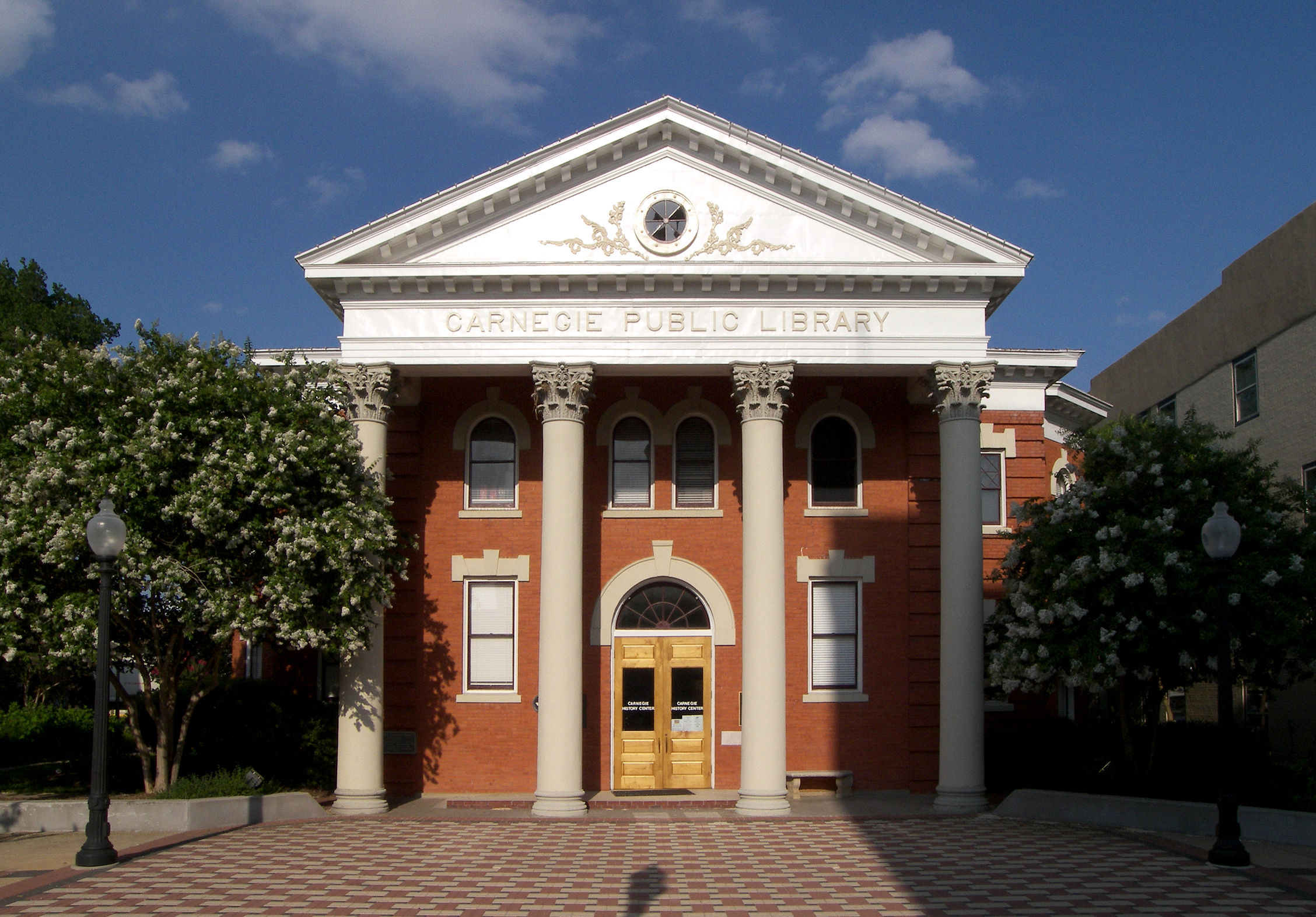
30°40′12″N 96°22′38″W / 30.67°N 96.377222°WBryan 7 Bryan Carnegie Library 
October 27, 1976 111 S. Main St.
30°40′22″N 96°22′24″W / 30.672778°N 96.373333°WBryan 8 Bryan Compress and Warehouse September 25, 1987 911 N. Bryan
30°40′54″N 96°22′20″W / 30.681667°N 96.372222°WBryan 9 Bryan Ice House September 25, 1987 107 E. Martin Luther King
30°40′25″N 96°22′40″W / 30.673611°N 96.377778°WBryan 10 Bryan Municipal Building February 20, 2002 111 E. 27th St.
30°40′16″N 96°22′15″W / 30.671111°N 96.370833°WBryan 11 Cavitt House October 27, 1976 713 E. 30th St.
30°39′58″N 96°22′02″W / 30.666111°N 96.367222°WBryan 12 James O. Chance House September 25, 1987 102 S. Parker
30°40′25″N 96°22′31″W / 30.673611°N 96.375278°WBryan 13 CSPS Lodge-Griesser Bakery September 25, 1987 304 N. Logan
30°40′35″N 96°22′40″W / 30.676389°N 96.377778°WBryan 14 East Side Historic District September 25, 1987 Roughly bounded by Houston, Twenty-ninth, Haswell, and E. Thirtieth Sts.
30°40′06″N 96°22′03″W / 30.668333°N 96.3675°WBryan 15 Eugene Edge House September 25, 1987 609 S. Ennis
30°39′53″N 96°21′56″W / 30.664722°N 96.365556°WBryan 16 English-Dansby House September 25, 1987 204 W. Twenty-eighth
30°40′19″N 96°22′28″W / 30.671944°N 96.374444°WBryan 17 English-Poindexter House September 25, 1987 206 W. Twenty-eighth
30°40′19″N 96°22′30″W / 30.671944°N 96.375°WBryan 18 First National Bank and Trust Building September 25, 1987 120 N. Main
30°40′27″N 96°22′24″W / 30.674167°N 96.373333°WBryan 19 First State Bank and Trust Building September 25, 1987 100 W. Twenty-fifth
30°40′30″N 96°22′24″W / 30.675°N 96.373333°WBryan 20 Walter J. Higgs House September 25, 1987 609 N. Tabor
30°40′55″N 96°22′14″W / 30.681944°N 96.370556°WBryan 21 House at 109 N. Sterling September 25, 1987 109 N. Sterling
30°40′31″N 96°22′36″W / 30.675278°N 96.376667°WBryan 22 House at 1401 Baker September 25, 1987 1401 Baker
30°40′15″N 96°21′56″W / 30.670833°N 96.365556°WBryan 23 House at 407 N. Parker September 25, 1987 407 N. Parker
30°40′04″N 96°22′28″W / 30.667778°N 96.374444°WBryan 24 House at 600 N. Washington September 25, 1987 600 N. Washington
30°40′41″N 96°22′14″W / 30.678056°N 96.370556°WBryan 25 House at 603 E. Thirty-first September 25, 1987 603 E. Thirty-first
30°39′57″N 96°22′07″W / 30.665833°N 96.368611°WBryan 26 House at 604 E. Twenty-seventh September 25, 1987 604 E. Twenty-seventh
30°40′20″N 96°22′02″W / 30.672222°N 96.367222°WBryan 27 Humpty Dumpty Store September 25, 1987 218 N. Bryan
30°40′31″N 96°22′25″W / 30.675278°N 96.373611°WBryan 28 Edward J. Jenkins House September 25, 1987 607 E. Twenty-seventh
30°40′18″N 96°22′02″W / 30.671667°N 96.367222°WBryan 29 J. M. Jones House September 25, 1987 812 S. Ennis
30°39′50″N 96°22′00″W / 30.663889°N 96.366667°WBryan 30 E. A. Kemp House September 25, 1987 606 W. Seventeenth
30°40′56″N 96°22′01″W / 30.682222°N 96.366944°WBryan 31 La Salle Hotel 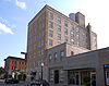
May 26, 2000 120 S. Main St.
30°40′23″N 96°22′25″W / 30.673056°N 96.373611°WBryan 32 McDougal-Jones House September 25, 1987 600 E. Twenty-seventh
30°40′20″N 96°22′03″W / 30.672222°N 96.3675°WBryan 33 Moore House September 25, 1987 500 E. Twenty-fifth
30°40′27″N 96°22′06″W / 30.674167°N 96.368333°WBryan 34 Noto House September 25, 1987 900 N. Parker
30°40′56″N 96°22′26″W / 30.682222°N 96.373889°WBryan 35 Dr. William Holt Oliver House September 25, 1987 602 W. Twenty-sixth
30°40′27″N 96°22′43″W / 30.674167°N 96.378611°WBryan 36 Parker Lumber Company Complex September 25, 1987 419 N. Main
30°40′37″N 96°22′20″W / 30.676944°N 96.372222°WBryan 37 Milton Parker House September 25, 1987 200 S. Congress
30°40′23″N 96°22′50″W / 30.673056°N 96.380556°WBryan 38 Saint Andrew's Episcopal Church 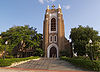
September 25, 1987 217 W. Twenty-sixth
30°40′25″N 96°22′29″W / 30.673611°N 96.374722°WBryan 39 Saint Anthony's Catholic Church September 25, 1987 306 S. Parker
30°40′16″N 96°22′32″W / 30.671111°N 96.375556°WBryan 40 Sausley House September 25, 1987 700 N. Washington
30°40′45″N 96°22′44″W / 30.679167°N 96.378889°WBryan 41 Old Sinclair Station September 25, 1987 507 S. Texas
30°40′09″N 96°22′13″W / 30.669167°N 96.370278°WBryan 42 Smith-Barron House June 20, 1988 100 S. Congress
30°40′26″N 96°22′49″W / 30.673889°N 96.380278°WBryan 43 Roy C. Stone House September 25, 1987 715 E. Thirty-first
30°39′52″N 96°22′00″W / 30.664444°N 96.366667°WBryan 44 Temple Freda September 22, 1983 205 Parker St.
30°40′21″N 96°22′30″W / 30.6725°N 96.375°WBryan 45 Minnie Zulch Zimmerman House September 25, 1987 308 N. Washington
30°40′33″N 96°22′15″W / 30.675833°N 96.370833°WBryan See also
- Registered Historic Places in Texas, Counties A-C
References
- ^ The latitude and longitude information provided in this table was derived originally from the National Register Information System, which has been found to be fairly accurate for about 99% of listings. For about 1% of NRIS original coordinates, experience has shown that one or both coordinates are typos or otherwise extremely far off; some corrections may have been made. A more subtle problem causes many locations to be off by up to 150 yards, depending on location in the country: most NRIS coordinates were derived from tracing out latitude and longitudes off of USGS topographical quadrant maps created under the North American Datum of 1927, which differs from the current, highly accurate WGS84 GPS system used by Google maps. Chicago is about right, but NRIS longitudes in Washington are higher by about 4.5 seconds, and are lower by about 2.0 seconds in Maine. Latitudes differ by about 1.0 second in Florida. Some locations in this table may have been corrected to current GPS standards.
- ^ "National Register of Historic Places: Weekly List Actions". National Park Service, United States Department of the Interior. Retrieved on November 10, 2011.
- ^ Numbers represent an ordering by significant words. Various colorings, defined here, differentiate National Historic Landmark sites and National Register of Historic Places Districts from other NRHP buildings, structures, sites or objects.
- ^ "National Register Information System". National Register of Historic Places. National Park Service. . http://nrhp.focus.nps.gov/natreg/docs/All_Data.html.
U.S. National Register of Historic Places Topics Lists by states Alabama • Alaska • Arizona • Arkansas • California • Colorado • Connecticut • Delaware • Florida • Georgia • Hawaii • Idaho • Illinois • Indiana • Iowa • Kansas • Kentucky • Louisiana • Maine • Maryland • Massachusetts • Michigan • Minnesota • Mississippi • Missouri • Montana • Nebraska • Nevada • New Hampshire • New Jersey • New Mexico • New York • North Carolina • North Dakota • Ohio • Oklahoma • Oregon • Pennsylvania • Rhode Island • South Carolina • South Dakota • Tennessee • Texas • Utah • Vermont • Virginia • Washington • West Virginia • Wisconsin • WyomingLists by territories Lists by associated states Other Categories:- Brazos County, Texas
- National Register of Historic Places in Texas
- Buildings and structures in Brazos County, Texas
-


Wikimedia Foundation. 2010.