- National Register of Historic Places listings in Baker County, Oregon
-
This is a list of properties and districts in Baker County, Oregon that are listed on the National Register of Historic Places.
Current listings
[1] Landmark name[2] Image Date listed[2] Location[3] City or Town[4] Summary 1 Antlers Guard Station 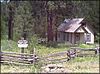
March 6, 1991 Southeast of Whitney in the Wallowa-Whitman National Forest
44°38′00.23″N 118°16′45.06″W / 44.6333972°N 118.2791833°W[5]Unity 2 Baker Historic District 
December 14, 1978 Along Main Street[2]
44°46′29″N 117°49′53″W / 44.77482°N 117.8314°WBaker City 3 Baker Municipal Natatorium image pending October 17, 1977 2470 Grove Street
44°46′53″N 117°49′33″W / 44.78133°N 117.8259°WBaker City 4 Churchill School image pending March 5, 2008 3451 Broadway Street
44°46′39.39″N 117°50′57.35″W / 44.7776083°N 117.8492639°W[5]Baker City 5 Robert F. and Elizabeth Clark House image pending October 30, 1989 1522 Washington Avenue
44°46′38″N 117°49′25″W / 44.77711°N 117.8237°WBaker City 6 James O. Maxwell Farmstead image pending November 6, 1986 Muddy Creek Road, Route 2, Box 82[2]
44°56′17″N 117°59′38″W / 44.93802°N 117.9939°WHaines 7 Oregon Commercial Company Building image pending June 4, 1992 40-50 E. Washington Street
44°21′04.31″N 117°16′03.20″W / 44.3511972°N 117.267556°W[5]Huntington 8 Ed Rand House image pending December 9, 1981 1700 4th Street
44°46′28″N 117°50′04″W / 44.77457°N 117.8344°WBaker City 9 St. Elizabeth Hospital (Old) image pending February 21, 1989 2365 4th Street
44°46′50″N 117°50′04″W / 44.7805°N 117.8344°WBaker City 10 Sumpter Valley Gold Dredge 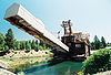
October 26, 1971 Southwest of Sumpter near Cracker Creek
44°44′30″N 118°12′14″W / 44.74155°N 118.2038°WSumpter Gold dredge used in placer mining along the Powder River beginning in the 1930s, representing a late, highly-mechanized phase of gold mining in Eastern Oregon.[6] 11 Sumpter Valley Railway Historic District 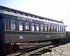
August 3, 1987 Roughly between Baker and Prairie City starting near the McEwen station site and west to the Dixie Pass area
44°37′13″N 118°20′07″W / 44.62038°N 118.3352°WBaker City to Prairie City[2] 12 Superintendent's House image pending August 20, 2004 271 Mill Street
44°44′39″N 118°12′07″W / 44.74403°N 118.2019°WSumpter 13 Unity Ranger Station 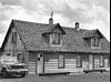
April 11, 1986 44°26′12″N 118°11′17″W / 44.43678°N 118.188°W Unity References
- ^ Numbers represent an ordering by significant words (e.g. last name). Various colorings (defined here) differentiate standalone NRHP sites from NRHP sites that also hold status as National Historic Landmarks, historic districts, National Historical Parks, or hold other historic designations.
- ^ a b c d e National Park Service. "National Register Information System". Archived from the original on 2008-05-28. http://web.archive.org/web/20080528011404/http://www.cr.nps.gov/NR/research/nris.htm. Retrieved 2008-10-09.
- ^ Text: Except as otherwise noted, all entries are drawn from: Oregon Parks and Recreation Department (2008-08-08). "Oregon National Register List". http://www.oregonheritage.org/OPRD/HCD/NATREG/docs/oregon_nr_list.pdf..
Coordinates: Except as otherwise noted, all entries are drawn from Google Earth KMZ files available at: National Park Service. "National Register Information System". http://www.cr.nps.gov/NR/research/nris.htm. - ^ Except as otherwise noted, all entries are drawn from: Oregon Parks and Recreation Department (2008-08-08). "Oregon National Register List". http://www.oregonheritage.org/OPRD/HCD/NATREG/docs/oregon_nr_list.pdf. Retrieved 2008-10-09.
- ^ a b c Coordinates adjusted for accuracy by editor.
- ^ Oregon Parks and Recreation Department. "Sumpter Valley Dredge State Heritage Area". http://www.oregonstateparks.org/park_239.php. Retrieved 2008-10-12.
U.S. National Register of Historic Places in Oregon Lists by county Baker • Benton • Clackamas • Clatsop • Columbia • Coos • Crook • Curry • Deschutes • Douglas • Gilliam • Grant • Harney • Hood River • Jackson • Jefferson • Josephine • Klamath • Lake • Lane • Lincoln • Linn • Malheur • Marion • Morrow • Multnomah: Portland North • Multnomah: Portland Northeast • Multnomah: Portland Northwest • Multnomah: Portland Southeast • Multnomah: Portland Southwest • Multnomah: Other • Polk • Sherman • Tillamook • Umatilla • Union • Wallowa • Wasco • Washington • Wheeler • Yamhill
Other lists Categories:- National Register of Historic Places listings by county in Oregon
- Baker County, Oregon


Wikimedia Foundation. 2010.