- National Register of Historic Places listings in Adams County, Pennsylvania
-
 Location of Adams County in Pennsylvania
This is a list of the National Register of Historic Places listings in Adams County, Pennsylvania.
This is intended to be a complete list of the properties and districts on the National Register of Historic Places in Adams County, Pennsylvania, United States. The locations of National Register properties and districts for which the latitude and longitude coordinates are included below, may be seen in a Google map.[1]
There are 32 properties and districts listed on the National Register in the county. One site is further designated as a National Historic Site and another is designated as a National Military Park. Another property was once listed but has been removed.
-
- This National Park Service list is complete through NPS recent listings posted November 10, 2011.[2]
Current listings
[3] Landmark name Image Date listed Location City or town Summary 1 John Abbott House 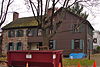
February 22, 1980 East King Street
39°53′14″N 76°58′55″W / 39.887222°N 76.981944°WAbbottstown 2 Adams County Courthouse 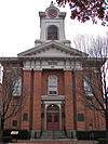
October 1, 1974 Baltimore and West Middle Streets
39°49′46″N 77°13′57″W / 39.829444°N 77.2325°WGettysburg 3 Black Horse Tavern 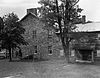
March 30, 1978 West of Gettysburg on Pennsylvania Route 116
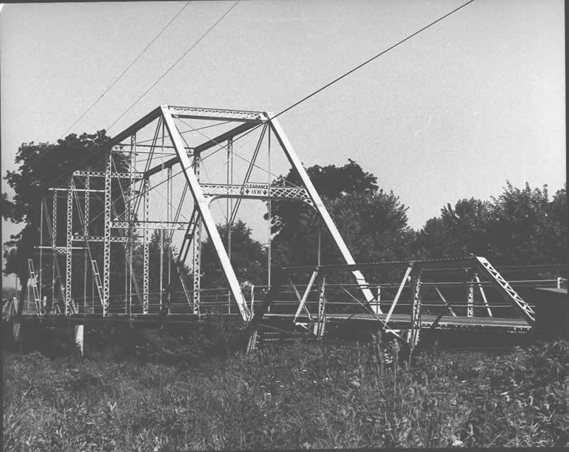
39°49′08″N 77°17′02″W / 39.818889°N 77.283889°WCumberland Township 4 Bridge in Cumberland Township 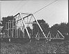
June 22, 1988 Legislative Route 01002 over Marsh Creek, near Greenmount
39°45′27″N 77°17′06″W / 39.7575°N 77.285°WCumberland and Freedom Townships 5 Carbaugh Run Rhyolite Quarry Site (36AD30) January 15, 1986 Atop Snaggy Ridge, west of Carbaugh Run
39°53′2.4″N 77°27′26.388″W / 39.884°N 77.45733°W[4]Franklin Township 6 Cline's Church of the United Brethren in Christ August 22, 2002 Cline's Church Road, 0.5 miles (0.80 km) south of Pennsylvania Route 34, near Menallen
40°00′02″N 77°13′14″W / 40.000556°N 77.220556°WMenallen Township 7 Conewago Chapel January 29, 1975 3 miles (4.8 km) northwest of Hanover
39°49′08″N 77°02′17″W / 39.818889°N 77.038056°WConewago Township 8 Dobbin House 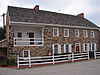
March 26, 1973 89 Steinwehr Avenue
39°49′20″N 77°13′59″W / 39.822222°N 77.233056°WGettysburg 9 East Berlin Historic District 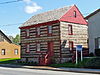
September 30, 1985 Portions of King, Harrisburg, and Abbottstown Streets
39°56′17″N 76°58′56″W / 39.938056°N 76.982222°WEast Berlin 10 Eisenhower National Historic Site 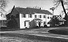
November 27, 1967 200 Eisenhower Farm Lane, near Gettysburg
39°47′45″N 77°16′2″W / 39.79583°N 77.26722°WCumberland Township 11 Fairfield Historic District May 18, 2000 Roughly bounded by Landis Drive, Steelman Street, Wortz Drive, and the northwestern borough boundary
39°47′36″N 77°22′10″W / 39.793333°N 77.369444°WFairfield 12 Fairfield Inn 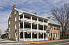
April 2, 1973 Main Street
39°47′13″N 77°22′11″W / 39.787°N 77.369597°WFairfield 13 Gettysburg Armory 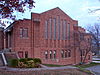
April 18, 1990 315 West Confederate Avenue
39°49′37″N 77°14′38″W / 39.826944°N 77.243889°WGettysburg 14 Gettysburg Battlefield Historic District 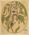
March 19, 1975 Town of Gettysburg and its environs
39°48′59″N 77°13′49″W / 39.816389°N 77.230278°WCumberland Township, Gettysburg, and Highland Township 15 Gettysburg National Military Park 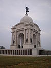
October 15, 1966 Gettysburg National Military Park, near Gettysburg
39°48′43″N 77°14′39″W / 39.81194°N 77.24417°WCumberland, Highland, and Straban Townships 16 Great Conewago Presbyterian Church December 27, 1974 Church Road, near Hunterstown
39°53′15″N 77°09′46″W / 39.8875°N 77.162778°WStraban Township 17 Heikes Covered Bridge August 25, 1980 North of Heidlersburg on Township 5857
39°58′41″N 77°08′47″W / 39.978056°N 77.146389°WHuntington and Tyrone Townships 18 Horner House and Barn May 24, 2007 20 Horner Road
39°43′41″N 77°14′59″W / 39.728056°N 77.249722°WCumberland Township 19 Hunterstown Historic District May 15, 1979 Pennsylvania Route 394 and Granite Station Road, in Hunterstown
39°53′03″N 77°09′36″W / 39.884167°N 77.16°WStraban Township 20 Jacks Mountain Covered Bridge August 25, 1980 Southwest of Fairfield on Legislative Route 01053, near Iron Springs
39°46′01″N 77°23′13″W / 39.766944°N 77.386944°WCarroll Valley and Hamiltonban Township 21 John's Burnt Mill Bridge December 16, 1974 Southwest of New Oxford on Township 428
39°49′56″N 77°04′47″W / 39.832222°N 77.079722°WMount Pleasant and Oxford Townships 22 Lower Marsh Creek Presbyterian Church October 15, 1980 Southeast of Orrtanna on Legislative Route 01002
39°48′42″N 77°19′59″W / 39.811667°N 77.333056°WHighland Township 23 Lutheran Theological Seminary-Old Dorm 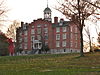
May 3, 1974 Seminary Ridge, Lutheran Theological Seminary campus
39°49′55″N 77°14′41″W / 39.831944°N 77.244722°WGettysburg 24 Pennsylvania Hall, Gettysburg College 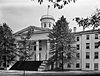
March 16, 1972 Gettysburg College campus
39°50′06″N 77°14′05″W / 39.835°N 77.234722°WGettysburg 25 Pond Mill Bridge 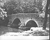
June 22, 1988 Legislative Route 01009 over Bermudian Creek, near Bermudian
39°59′45″N 77°03′31″W / 39.995833°N 77.058611°WLatimore Township 26 Rock Creek-White Run Union Hospital Complex May 18, 2000 Baltimore Pike, Goulden Road, and White Church Road, near Mount Joy
39°47′20″N 77°11′59″W / 39.788889°N 77.199722°WCumberland Township, Gettysburg, and Mount Joy Township 27 Sauck's Covered Bridge 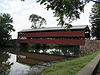
August 25, 1980 Waterworks Road over Marsh Creek
39°47′51″N 77°16′35″W / 39.7975°N 77.276389°WCumberland and Freedom Townships 28 Sheads House 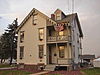
December 8, 1976 331 Buford Avenue
39°50′03″N 77°14′35″W / 39.834167°N 77.243056°WGettysburg 29 Spangler-Benner Farm October 29, 1992 230 Benner Road, near Gettysburg
39°44′39″N 77°13′34″W / 39.744167°N 77.226111°WMount Joy Township 30 Thomas Brothers Store August 15, 2008 4 South Main Street
39°55′49″N 77°14′53″W / 39.93032°N 77.24792°WBiglerville 31 Wirts House January 22, 1992 798 Schrivers Corner Road (Pennsylvania Route 394), near Gettyburg
39°53′45″N 77°11′58″W / 39.895833°N 77.199444°WStraban Township 32 John Zeigler Farm House May 7, 1992 1281 Mountain Road, near York Springs
40°02′56″N 77°07′02″W / 40.048889°N 77.117222°WLatimore Township Former listing
[3] Landmark name Image Date listed Location City or town Summary 1 Conewango Mass House January 11, 1996 North of McSherrystown on Pennsylvania Route 476, Conewago Township McSherrystown 2 Conewango Chapel Covered Bridge June 27, 1986 Legislative Route 01060 Conewago Township Listed on August 25, 1980 See also
- List of National Historic Landmarks in Pennsylvania
- National Register of Historic Places listings in Pennsylvania
- List of Pennsylvania state historical markers in Adams County
References
- ^ The latitude and longitude information provided in this table was derived originally from the National Register Information System, which has been found to be fairly accurate for about 99% of listings. For about 1% of NRIS original coordinates, experience has shown that one or both coordinates are typos or otherwise extremely far off; some corrections may have been made. A more subtle problem causes many locations to be off by up to 150 yards, depending on location in the country: most NRIS coordinates were derived from tracing out latitude and longitudes off of USGS topographical quadrant maps created under the North American Datum of 1927, which differs from the current, highly accurate WGS84 GPS system used by Google maps. Chicago is about right, but NRIS longitudes in Washington are higher by about 4.5 seconds, and are lower by about 2.0 seconds in Maine. Latitudes differ by about 1.0 second in Florida. Some locations in this table may have been corrected to current GPS standards.
- ^ "National Register of Historic Places: Weekly List Actions". National Park Service, United States Department of the Interior. Retrieved on November 10, 2011.
- ^ Numbers represent an ordering by significant words. Various colorings, defined here, differentiate National Historic Landmark sites and National Register of Historic Places Districts from other NRHP buildings, structures, sites or objects.
- ^ Location derived from its NRHP nomination form; the NRIS lists the site as "Address Restricted"
Municipalities and communities of Adams County, Pennsylvania Boroughs 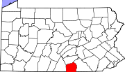
Townships Berwick | Butler | Conewago | Cumberland | Franklin | Freedom | Germany | Hamilton | Hamiltonban | Highland | Huntington | Latimore | Liberty | Menallen | Mount Joy | Mount Pleasant | Oxford | Reading | Straban | Tyrone | Union
CDPs Unincorporated
communitiesBarlow | Beechersville | Bendersville | Bermudian | Bittinger | Cross Keys | Floradale | Fairplay | Gardners | Graefenburg | Greeenmount | Heidlersburg | Hunterstown | Idaville | Knoxlyn | Peach Glen | Round Top | Whitehall
Ghost town Tartown
Categories:- National Register of Historic Places in Pennsylvania by county
- Adams County, Pennsylvania
-


Wikimedia Foundation. 2010.