- National Register of Historic Places listings in Acadia National Park
-
This is a list of the National Register of Historic Places listings in Acadia National Park.
This is intended to be a complete list of the properties and districts on the National Register of Historic Places in Acadia National Park, Maine, United States. The locations of National Register properties and districts for which the latitude and longitude coordinates are included below, may be seen in a Google map.[1]
There are eight properties and districts listed on the National Register in the park.
-
- This National Park Service list is complete through NPS recent listings posted November 10, 2011.[2]
Current listings
[3] Landmark name Image Date listed Location City or town Summary 1 Baker Island Light Station 
March 14, 1988 Baker Island in Acadia National Park
44°14′28″N 68°11′56″W / 44.241111°N 68.198889°WIslesford 2 Bear Island Light Station 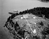
March 14, 1988 Bear Island, Acadia National Park
44°17′00″N 68°16′14″W / 44.283333°N 68.270556°WNortheast Harbor 3 Blackwoods Campground June 29, 2007 State Route 233, Eagle Lake Rd. Bar Harbor 4 Carriage Paths, Bridges and Gatehouses 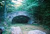
November 14, 1979 Acadia National Park and vicinity
44°20′32″N 68°15′30″W / 44.342222°N 68.258333°WAcadia National Park 5 Fernald Point Prehistoric Site July 21, 1978 Address Restricted Southwest Harbor 6 Islesford Historical Museum and Blue Duck Ships Store September 30, 1980 Little Cranberry Island
44°15′42″N 68°14′25″W / 44.261667°N 68.240278°WIslesford 7 Schoodic Peninsula Historic District June 29, 2007 1.5 miles south of State Route 186 Winter Harbor 8 Seawall Campground June 29, 2007 State Route 233, Eagle Lake Rd. Bar Harbor See also
- National Register of Historic Places listings in Hancock County, Maine
- National Register of Historic Places listings in Maine
References
- ^ The latitude and longitude information provided in this table was derived originally from the National Register Information System, which has been found to be fairly accurate for about 99% of listings. For about 1% of NRIS original coordinates, experience has shown that one or both coordinates are typos or otherwise extremely far off; some corrections may have been made. A more subtle problem causes many locations to be off by up to 150 yards, depending on location in the country: most NRIS coordinates were derived from tracing out latitude and longitudes off of USGS topographical quadrant maps created under the North American Datum of 1927, which differs from the current, highly accurate WGS84 GPS system used by Google maps. Chicago is about right, but NRIS longitudes in Washington are higher by about 4.5 seconds, and are lower by about 2.0 seconds in Maine. Latitudes differ by about 1.0 second in Florida. Some locations in this table may have been corrected to current GPS standards.
- ^ "National Register of Historic Places: Weekly List Actions". National Park Service, United States Department of the Interior. Retrieved on November 10, 2011.
- ^ Numbers represent an ordering by significant words. Various colorings, defined here, differentiate National Historic Landmark sites and National Register of Historic Places Districts from other NRHP buildings, structures, sites or objects.
National Register of Historic Places in Acadia National Park Historic districts Baker Island Light Station | Bear Island Light Station | Blackwoods Campground | Carriage Paths, Bridges and Gatehouses | Schoodic Peninsula Historic District | Seawall Campground
Other properties Fernald Point Prehistoric Site | Islesford Historical Museum and Blue Duck Ships Store
See also: National Register of Historic Places listings in Acadia National ParkU.S. National Register of Historic Places Topics Lists by states Alabama • Alaska • Arizona • Arkansas • California • Colorado • Connecticut • Delaware • Florida • Georgia • Hawaii • Idaho • Illinois • Indiana • Iowa • Kansas • Kentucky • Louisiana • Maine • Maryland • Massachusetts • Michigan • Minnesota • Mississippi • Missouri • Montana • Nebraska • Nevada • New Hampshire • New Jersey • New Mexico • New York • North Carolina • North Dakota • Ohio • Oklahoma • Oregon • Pennsylvania • Rhode Island • South Carolina • South Dakota • Tennessee • Texas • Utah • Vermont • Virginia • Washington • West Virginia • Wisconsin • WyomingLists by territories Lists by associated states Other Categories:- National Register of Historic Places lists in the National Park Service
- Acadia National Park
-


Wikimedia Foundation. 2010.