- Naval Auxiliary Landing Field Fentress
-
NALF Fentress 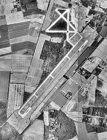
USGS aerial image - 9 April 1990 IATA: none – ICAO: KNFE – FAA LID: NFE Summary Airport type Military Owner U.S. Navy Location Fentress, Chesapeake, Virginia Elevation AMSL 16 ft / 5 m Coordinates 36°41′31″N 076°08′04″W / 36.69194°N 76.13444°W Runways Direction Length Surface ft m 5/23 8,004 2,440 Asphalt Source: Federal Aviation Administration[1] Naval Auxiliary Landing Field Fentress (ICAO: KNFE, FAA LID: NFE) is a military use airport located in Fentress,[1] part of the independent city of Chesapeake in the U.S. state of Virginia. This military airport is owned by the U.S. Navy and is under the operational control of Naval Air Station Oceana, Virginia. The airfield primarily supports day and night Field Carrier Landing Practice (FCLP) operations by US Navy and US Marine Corps F/A-18 Hornet, and US Navy F/A-18 Super Hornet, E-2 Hawkeye and C-2 Greyhound aircraft based in Virginia and the Carolinas. [1]
Although many U.S. airports use the same three-letter location identifier for the FAA and IATA, this airport is assigned NFE by the FAA but has no designation from the IATA.[2]
Facilities
Fentress NALF has one operational runway designated Runway 5/23 with an asphalt surface measuring 8,004 by 175 feet (2,440 x 53 m).[1] Four additional shorter paved runways dating from the airfield's original construction during World War II are located in the airfield's northern quadrant. These additional runways are closed to aircraft. On July 5th, 2011, it was announced that NALF Fentress would close in January 2012 for 9 months for major repairs. Touch and go maneuvers would move to Naval Air Station Oceana and Naval Station Norfolk/Chambers Field. [3]
References
- ^ a b c d FAA Airport Master Record for NFE (Form 5010 PDF). Federal Aviation Administration. Effective 8 April 2010.
- ^ "NALF Fentress (FAA: NFE)". Great Circle Mapper. http://www.gcmap.com/airport/KNFE. Retrieved 22 April 2010.
- ^ the virginian pilot july 5, 2011
External links
- Aerial photo as of 9 April 1990 from USGS The National Map
- Resources for this airport:
- AirNav airport information for NFE
- FlightAware airport information and live flight tracker
- SkyVector aeronautical chart for NFE
Categories:- Airports in Virginia
- Buildings and structures in Chesapeake, Virginia
- United States Naval Auxiliary Landing Fields
- Transportation in Chesapeake, Virginia

Wikimedia Foundation. 2010.