- Mount Charleston Wilderness
-
Mount Charleston Wilderness IUCN Category Ib (Wilderness Area)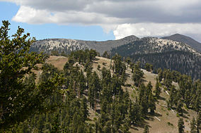
Bristlecone pines blanket the high ridge between Charleston and Griffith Peaks.

Location Clark County, Nevada, USA Nearest city Las Vegas, NV Coordinates 36°17′53″N 115°39′51″W / 36.29806°N 115.66417°WCoordinates: 36°17′53″N 115°39′51″W / 36.29806°N 115.66417°W Area 57,442 acres (23,246 ha) Established January 1, 1989 Governing body U.S. Forest Service
Bureau of Land ManagementThe Mount Charleston Wilderness Area is located west of Las Vegas in the southern part of the state of Nevada in the Western United States. It was created by the U.S. Congress in 1989 under the provisions allowed by the Wilderness Act of 1964, and is managed by both the Bureau of Land Management and the U.S. Forest Service.
Contents
Geography
The Mount Charleston Wilderness Area consists of a total of 57,442 acres (23,246 ha) of protected wilderness, with the BLM managing 2,142 acres (867 ha) and the rest by the U.S. Forest Service.
The Wilderness Area extends across the entire Spring Mountains Range, including the highest point of Mount Charleston (Charleston Peak), at an elevation of 11,908 ft (3,630 m).
Habitat
The Mount Charleston Wilderness Area is also home to around 18,000 acres (7,300 ha) of Bristlecone pine, and is the largest collection of these trees in the Intermountain Region of the United States. The area also provides the only habitat for the only herd of Rocky Mountain Elk located within Clark County, according to the BLM.[citation needed]
Recreation
There are some 40 mi (64 km) of trails located within the Mount Charleston Wilderness Area, which can be accessed from the Spring Mountains National Recreation Area, commonly known as Mount Charleston.
See also
 Wilderness area sign alongside the South Loop trail; note remnants of an October snowfall on the path.
References
External links
- official Mount Charleston Wilderness Area website
- Wilderness.net wilderness information
- Topozone map of the wilderness
- official Humboldt-Toiyabe National Forest website
- National Atlas: Map of Humboldt-Toiyabe National Forest
Categories:- IUCN Category Ib
- Spring Mountains
- Humboldt-Toiyabe National Forest
- Wilderness Areas of Nevada
- Protected areas of Clark County, Nevada
- Bureau of Land Management areas in Nevada


Wikimedia Foundation. 2010.