- Mill Woods Park
-
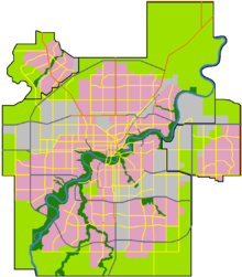
 Location of Mill Woods Park Area in Edmonton
Mill Woods Park is a large multi-recreational park located in the center of Mill Woods, Edmonton, just to the west of Mill Woods Town Centre. It serves as the school fields for both Holy Trinity and J Percy Page High Schools.
The park features picnic sites, water playground, small lake, paved walkways, sports field, and a skate park. It is also home to the Mill Woods Canada Day events with various musical performances, petting zoos, hay rides and other activities, with about 100,000 people in attendance each year. During the winter it becomes a popular spot for skiing and sledding.
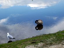 Waterfowl at the lake
The Mill Woods Recreation Centre which is in between the two schools has an indoor swimming pool, an exercise room, and two NHL-sized hockey rinks.
References
Parks in Alberta World Heritage Sites - Canadian Rocky Mountain Parks
- Dinosaur Provincial Park
- Head-Smashed-In Buffalo Jump
- Waterton Glacier International Peace Park
- Wood Buffalo National Park

National parks Provincial parks Urban parks - Calgary Zoo
- Devonian Gardens
- Edworthy Park
- Mill Woods Park
- Muttart Conservatory
- North Saskatchewan River Valley
- Nose Hill
- Oldman River Valley
- Edmonton Valley Zoo
- Pearce Estate Wetland
Museums and historic sites - Alberta Central Railway Museum
- Canadian Grain Elevator Discovery Center
- Cold Lake Air Force
- Ellis Bird Farm
- Fort Calgary
- Fort Edmonton Park
- Fort Victoria
- Fort Whoop-Up
- Frank Slide
- Galt Historic Railway Park
- Heritage Acres Farm Museum
- Heritage Park
- Krause Milling Co.
- Pioneer Acres
- Prairie Elevator Museum
- Reynolds-Alberta
- Ritchie Mill
- Royal Alberta
- Royal Tyrrell
- Scandia Eastern Irrigation District Museum
- Spruce Grove Grain Elevator Museum
- St. Albert Grain Elevator Park
- South Peace Centennial Museum
- Ukrainian Village
- Warner elevator row
- Whyte
- National historic sites
- Provincial historic sites
Coordinates: 53°27′22″N 113°26′13″W / 53.45611°N 113.43694°W
Categories:- Parks in Edmonton
- Visitor attractions in Edmonton
- Edmonton stubs


Wikimedia Foundation. 2010.