Midgeholme

Midgeholme

Coordinates: 54°55′26″N 2°33′55″W / 54.924°N 2.5654°W / 54.924; -2.5654

Midgeholme
Moorland, Midgeholme - geograph.org.uk - 781728.jpg
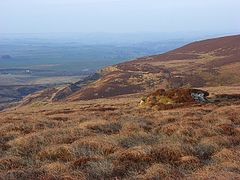
Moorland at Midgeholme
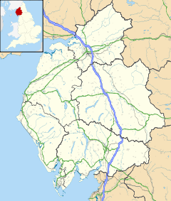
Midgeholme is located in Cumbria
Midgeholme

 Midgeholme shown within Cumbria
Population 67 (2001)
OS grid reference SD2980
Parish Midgeholme
District City of Carlisle
Shire county Cumbria
Region North West
Country England
Sovereign state United Kingdom
Police Cumbria
Fire Cumbria
Ambulance North West
EU Parliament North West England
UK Parliament Penrith and The Border
List of places: UK • England • Cumbria

Midgeholme is a place and civil parish in the City of Carlisle district,[1] in the county of Cumbria, England. It was formerly in Border Rural District[2] It is located about 8 miles (13 km) East of Brampton.[3] Midgeholme has 1 listed building[4] called Tarn House, which is Grade II* listed.[5] The population of the civil parish of Midgeholme was 54 in 1971[6] and 67 in 2001.[7] There was once a school in Midgeholme.[8] It is also the location of Midgeholme Coalfield.[9] There is also Midgeholme Bridge in Midgeholme,[10] which carries the A689 over Hartley Burn.[11]

References

External links

[Legend
Unknown BSicon "exKHSTa"
Brampton Town/Brampton Coal Staithe Closed 1923
Unknown BSicon "exABZlf" Unknown BSicon "exSTRlg"
Unknown BSicon "exSTR" Unknown BSicon "exSTR"
Line of 1836/Line of 1776
Unknown BSicon "exHST" Unknown BSicon "exSTR"
Brampton   Newcastle and Carlisle Railway Opened 1836
Unknown BSicon "exSTR" Unknown BSicon "exSTR"
Kirkhouse
Unknown BSicon "exSTR" Unknown BSicon "exSTR"
Inclined plane
Unknown BSicon "exBUE" Unknown BSicon "exSTR"
A689
Unknown BSicon "exABZrg" Unknown BSicon "exSTRrf"
Unknown BSicon "exHST"
Hallbankgate
Unknown BSicon "exBUE"
A689
Unknown BSicon "exSTRrg" Unknown BSicon "exABZrf"
Black Syke Junction
Unknown BSicon "exSTRrg" Unknown BSicon "exABZrf" Unknown BSicon "exSTR"
Unknown BSicon "exSTR" Unknown BSicon "exKHSTe" Unknown BSicon "exABZlf" Unknown BSicon "exSTRlg"
Clowsgill Limeworks
Unknown BSicon "exSTR" Unknown BSicon "exSTR" Unknown BSicon "exKHSTe"
Howard Colliery
Unknown BSicon "exSTR" Unknown BSicon "exSTR" Unknown BSicon "exKHSTa"
Roachburn Colliery
Unknown BSicon "exSTR" Unknown BSicon "exABZrg" Unknown BSicon "exSTRrf"
Unknown BSicon "exSTR" Unknown BSicon "exSTR"
Unknown BSicon "exABZlf" Unknown BSicon "exSTRlg" Unknown BSicon "exSTR"
Unknown BSicon "exHST" Unknown BSicon "exSTR" Unknown BSicon "exSTR"
Foresthead Limeworks
Unknown BSicon "exSTR" Unknown BSicon "exKBFl" Unknown BSicon "exSTR"
Howgill Colliery
Unknown BSicon "exSTR" Unknown BSicon "exKHSTe" Unknown BSicon "exSTR"
Gairs Colliery
Unknown BSicon "exABZlf" Unknown BSicon "exSTRlg" Unknown BSicon "exSTR"
Unknown BSicon "exKHSTe" Unknown BSicon "exSTR" Unknown BSicon "exSTR"
Blacksyke Colliery
Unknown BSicon "exKHSTe" Unknown BSicon "exSTR"
Quarry
Unknown BSicon "exHST"
Tindale Fell Colliery Original end of the 1775 track
Unknown BSicon "exKHSTa" Unknown BSicon "exSTR"
Bishop Hill Colliery
Unknown BSicon "exHST" Unknown BSicon "exSTR"
Tindalefell Spelter Works
Unknown BSicon "exSTRlf" Unknown BSicon "exABZlg"
Bishop Hill Junction
Unknown BSicon "exSTR"
Unknown BSicon "exHST"
Midgeholme
Unknown BSicon "exHST"
Halton Lea Gate End of the 1836 track
Unknown BSicon "exBUE"
Unknown BSicon "exABZlf" Unknown BSicon "exSTRlg"
Unknown BSicon "exKHSTe" Unknown BSicon "exSTR"
Lambley Colliery End of the 1849 track
Unknown BSicon "exCONTf"
Lambley   Alston Line 1852

Wikimedia Foundation. 2010.

Игры ⚽ Поможем написать реферат

Look at other dictionaries:

  • Midgeholme Coalfield — The Midgeholme Coalfield is a coalfield in Midgeholme,[1] on the border of Cumbria with Northumberland in northern England. It is the largest of a series of small coalfields along the south side of the Tyne Valley and which are intermediate… …   Wikipedia

  • City of Carlisle — This article is about the local government district of Cumbria. For other uses, see Carlisle. For the settlement in Cumbria named Carlisle, see Carlisle, Cumbria. City of Carlisle   City non metropolitan district   …   Wikipedia

  • List of civil parishes in Cumbria — This is a list of civil parishes in Cumbria, England. Most parishes have their own parish council, but some smaller parishes may have a parish meeting, or may join together as a combined parish council. Some larger parishes have town status, and… …   Wikipedia

  • Civil parishes in Cumbria — A map of Cumbria, showing the districts: (1) Barrow in Furness; (2) South Lakeland; (3) Copeland; (4) Allerdale; (5) Eden; and (6) Carlisle. A civil parish is a subnational entity, forming the lowest unit of local government in England. There are …   Wikipedia

  • List of coalfields — Coal reserves in BTUs as of 2009 A coalfield is an area of certain uniform characteristics where coal is mined. The criteria for determining the approximate boundary of a coalfield are geographical and cultural, in addition to geological. A… …   Wikipedia

  • Opening of the Liverpool and Manchester Railway — The Duke of Wellington s train and other locomotives being readied for departure from Liverpool, 15 September 1830 The opening of the Liverpool and Manchester Railway (L M) took place on 15 September 1830 …   Wikipedia

Share the article and excerpts

Direct link
Do a right-click on the link above
and select “Copy Link”