- North Hungarian Mountains
-
- This page is about the Hungarian geographical region, called "North Hungarian Mountains". For the similar region in Slovakia, see Mátra-Slanec Area.
North Hungarian Mountains 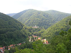
The view of the valley of Lillafüred in Bükk mountains. Although this is not the highest part of the county, the landscape is typical of Hungarian mountains. Location Northern Hungary, southern Slovakia Territory 13,000 km² (refers to Hungary only) Highest point Kékes (Hungary) 1012 m
Šimonka (Slovakia) 1092 mTerrain lower and moderately high mountains The North Hungarian Mountains (sometimes also referred to as Northeast Hungarian Mountains, Northeast Mountains, North Hungarian Highlands, North Hungarian Mid-Mountains or North Hungarian Range, Hungarian: Északi-középhegység)[1][2] is the northern, mountainous part of Hungary. It forms a geographical unity with the Mátra-Slanec Area, the adjacent parts of Slovakia. It is a separate geomorphological area within the Western Carpathians. The mountains run along in Northeast Hungary, and along the eastern parts of the Hungarian-Slovak border in a broad band from the Danube Bend to the town of Prešov.
Contents
Subdivisions
The area consists of the following geomorphological units:
- Börzsöny [3] (Hungarian: Börzsöny, literally: Logwood) + Burda (SK)
- Gödöllő Hills (Hungarian: Gödöllői-dombság)
- Cserhát[3] (Hungarian: Cserhát - literally "Turkey Oak Back", where "Cser" is Turkey Oak and "hát" is back)
- Karancs-Medves area + Cerová Highlands (SK)
- Mátra[3] (Hungarian: Mátra)
- Bükk[3] (Hungarian: Bükk or "Bükk hegység" – literally Beech (Mountains))
- Zemplén Mountains or Tokaj Mountains (Hungarian: Zempléni-hegység, Tokaji-hegység)
Ranges of the adjacent Mátra-Slanec Area in Slovakia:
Description
The North Hungarian Mountains begin with the mountain range of Börzsöny, adjacent to the Danube Bend, where it meets the Transdanubian Mountains.
The Börzsöny range is about 600 km² in area, and mainly of volcanic origin. The highest peak is the Csóványos (938 m).
The next range towards the east is the Cserhát, with the same geological composition as the Börzsöny. Erosion here was more severe: these are mere hills and comprise the lowest part of the North Hungarian Mountains. The highest point is the Naszály (654 m).
Kékes, the country's highest peak at 1014 metres, is located in the next range, Mátra. However, the range's average height is only 600 metres, less than that of the neighbouring Bükk. Mátra is also of volcanic origin.
 Map of the Carpathians. The North Hungarian Mountains are the most southern parts of the territory highlighted in light green.
The Bükk is a limestone range; it has the highest average height in Hungary. It is rich in caves, some of which were inhabited in ancient times.
The Aggtelek Karst area is a geologic formation spanning the Hungarian-Slovakian border, and the reason for the Caves of Aggtelek Karst and Slovak Karst World Heritage Site, and the Hungarian Aggtelek National Park. Hungary's most popular cave, the Baradla, is located there.
The Zemplén Mountains are again of volcanic origin; the soil's high quality favours viticulture.
Natural resources
- brown coal
- fertile soil
- forestry
- lignite
- limestone
- viticulture
National Parks
- Aggtelek National Park (established in 1985)
- Bükk National Park (established in 1976)
- Danube-Ipoly National Park (established in 1997)
 Panorama in Börzsöny Mountains (Duna-Ipoly National Park)
Protected areas
- Hollókő (since 1977)
- East Cserhát (since 1989)
- Karancs-Medves (since 1989)
- Mátra (since 1985)
- Tarnavidék (since 1993)
- Lázbérc (since 1975)
- Tokaj-Bodrogzug (since 1986)
- Zemplén (since 1984)
Images
-

Mátra mountains
-

Aggtelek National Park - Baradla Cave
-

The highest peak, Kékes
See also
- Bükk
- Carpathians
- Geography of Hungary
- Mátra
- Tokaj-Hegyalja (part of Zemplén Mountains)
References
- ^ Gábor Gercsák (2002). "Hungarian geographical names in English language publications" (in English). Studia Cartologica. Eötvös Loránd University. http://lazarus.elte.hu/~guszlev/tajnev/pdf/gg_studia.pdf. Retrieved 30 April 2011.
- ^ Gábor Gercsák (2005). "Magyar tájnevek angol fordítása" (in Hungarian). Fasciculi Linguistici / Series Lexicographica. Eötvös Loránd University. http://lazarus.elte.hu/~guszlev/tajnev/pdf/gg_magyar_tajn_ang_ford.pdf. Retrieved 30 April 2011.
- ^ a b c d Regional Map Series of Hungary
Geographical regions of Hungary 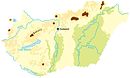 Hanság · Fertőzug · Neusiedl Basin · Rábaköz · Szigetköz · Marcali Basin · Moson Plain · Komárom-Esztergom PlainBaranya · Zala Hills · Inner Somogy · Outer Somogy · Zselic · Völgység · Szekszárd Hills · Baranya Hills · Villány Mountains
Transdanubian
MountainsKeszthely Mountains · Tapolca Basin · Balaton Uplands · Bakony · Bakonyalja · Sokoró · Vértesalja · Velence Mountains · Gerecse Mountains · Buda Mountains · Pilis Mountains · Visegrád Mountains · Vértes MountainsTransdanubian Hills North Hungarian
MountainsGreat Hungarian Plain Divisions, Groups, and Ranges of the Carpathian Mountains Western Carpathians Inner WesternSlovak Ore Mountains • Fatra-Tatra Area • Slovenské stredohorie • Lučenec-Košice Depression • Mátra-Slanec Area and North Hungarian MountainsOuter WesternSouth-Moravian Carpathians • Central Moravian Carpathians • Slovak-Moravian Carpathians • West-Beskidian Piedmont • Western Beskids • Central Beskids • Eastern Beskids • Podhale-Magura Area
Eastern Carpathians Inner EasternVihorlat-Gutin Area • Bistriţa Mountains • Căliman-Harghita Mountains • Giurgeu-Braşov DepressionOuter EasternCentral Beskidian Piedmont • Low Beskids • Eastern Beskids and the Ukrainian Carpathians • Moldavian-Muntenian CarpathiansSouthern Carpathians Romanian Western Carpathians Apuseni Mountains • Poiana Ruscă Mountains • Banat MountainsOther Categories:- Mountain ranges of Hungary
- Mountain ranges of the Western Carpathians


Wikimedia Foundation. 2010.