- Dresden–Werdau railway
-
Dresden Hbf–Werdau Bogendreieck junction Route number: 510, 510.3 Line number: 6258; 6257 Line length: 136.304 Gauge: 1435 Voltage: 15 kV, 16.7 Hz AC Maximum incline: 2.6 % Minimum radius: 213 Maximum speed: 120 km/h
with tilting: 160Legend

from Děčín 
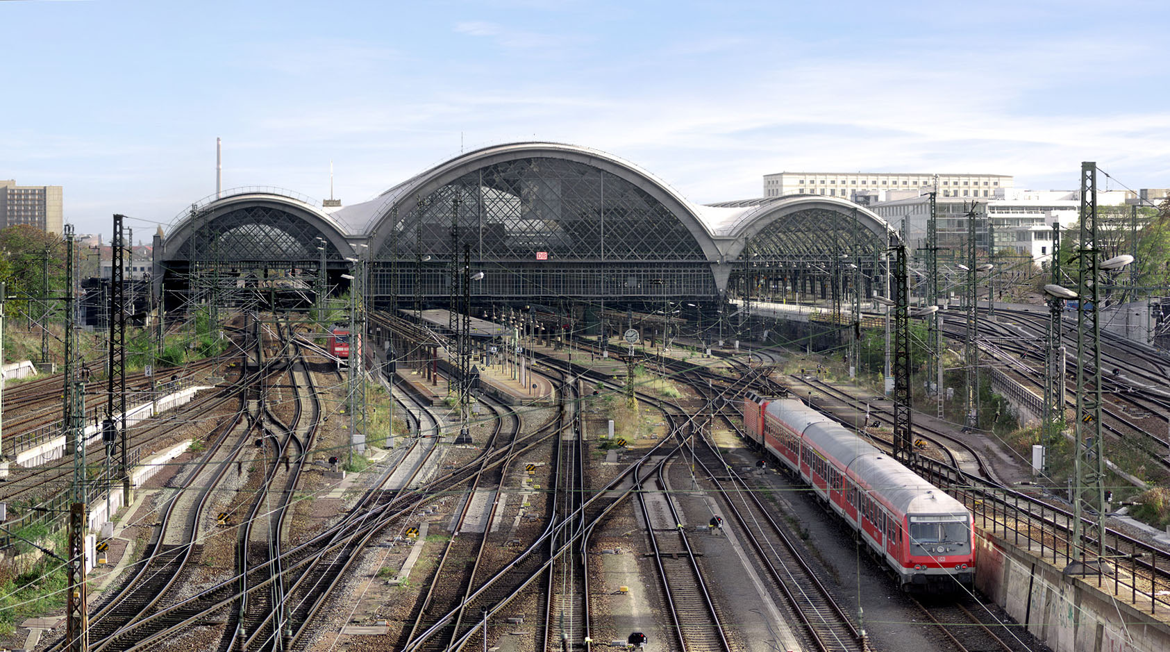
-0,048 Dresden Hbf 117 m 
to Dresden-Neustadt 
1.1 Dresden Altstadt junction (Bk) 
from Dresden-Altstadt Elbufer 
1.50 Dresden-Altstadt 120 m 
1.75 Zellescher Weg 
2.922 Dresden-Plauen since 1926 135 m 3.7 Dresden-Plauen until 1926 139 m 
Felsenkeller Tunnel, roof removed in 1895 (56 m) 
3.82 Bk Felsenkeller 
4.6 A 17 
5.528 Freight line to Tharandt 5.68 Freital Ost (Bk) junction 155 m 
5.717 to Possendorf 6.844 Freital-Potschappel 162 m 
Narrow gauge line to Nossen and Niederhermsdorf coal branch line 8.736 Freital-Deuben 176 m 10.092 Freital-Hainsberg 187 m 
Narrow gauge line to Kurort Kipsdorf 11.550 Freital-Hainsberg West 190 m 
Freight line from Freital Ost junction 13.705 Tharandt 208 m 15.92 Bk Breiter Grund 18.02 Edle Krone 281 m 
18.20 Edle Krone Tunnel (122 m) Maximum gradient 2.6 (1:37.5) 21.52 Bk Seerenteich 25.369 Klingenberg-Colmnitz 436 m Narrow gauge lines to Frauenstein and Mohorn 
27.45 Colmnitz Viaduct(148 m) 30.85 Niederbobritzsch 407 31.25 Niederbobritzsch Viaduct (175 m) 
Üst Niederbobritzsch 35.89 Muldenhütten 395 m 36.49 Muldenhütten Viaduct (196 m) 
38.5 Kunstgraben Tunnel (36 m; roof removed) from Halsbrücke 
from (Moldava–)Holzhau 40.005 Freiberg (Sachs) 413 m to Nossen 42.3 Bk Hospitalwald 
42.81 Nossen–Moldava 45.38 Kleinschirma 415 m 48.72 Frankenstein Viaduct (349 m) 49.819 Frankenstein (Sachs) 396 m 52.24 Bk Kaltes Feld 54.38 Bk Memmendorf 57.149 Oederan 407 m 59.10 Bk Breitenau 61.56 Bk Hetzdorf 

(Neutrassierung 1992) 
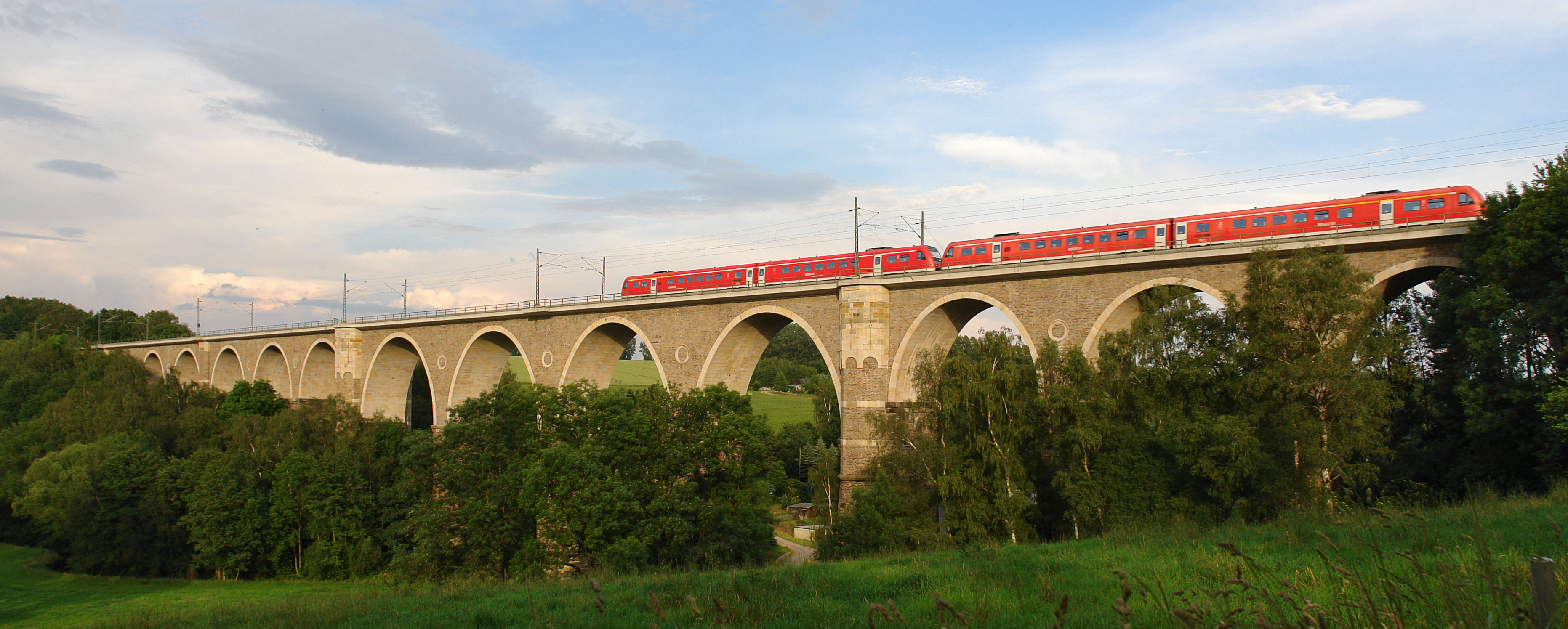
61.897 Hetzbach viaduct (344 m) 
62.300 Hetzdorf Viaduct (326 m) (Flöha Valley Railway) 62.805 Flöha viaduct (344 m) (Flöha Valley Railway) 


63.600 64.566 km change -966 m 64.75 Falkenau (Sachs) Süd (halt, formerly station) 310 m from Neuhausen and (Reitzenhain–) Marienberg from Vejprty 67.37 Flöha 278 m 
67.625 B 180 level crossing 68.079 Zschopau bridge (65 m) 70.13 Niederwiesa Stw 1 junction 70.170 B 73 LC from Roßwein 71.28 Niederwiesa 291 m 73,62 Bk Ebersdorf 76.02 0.000 km change (start of line 6257) 0.49 Chemnitz-Hilbersdorf 325 m 
76.52 Chemnitz-Hilbersdorf marshalling yard 320 m 

from Riesa and Neukieritzsch 3.098 78.60 km change (end of line 6257) from Riesa from Neukieritzsch 79.73 Chemnitz Hbf 302 m 81.82 Chemnitz Süd 312 m to Aue and Stollberg 82.63 Bk Chemnitz Süd 82.85 Chemnitz Mitte 307 m 
83.48 Chemnitz-Kappel 310 m 85.53 Chemnitz-Schönau 320 m 85.90 Bk Schönau B 72 88.01 Chemnitz-Siegmar 326 m 91.25 Grüna (Sachs) 350 m from Limbach and from Küchwald 
to Neuoelsnitz 94.31 Wüstenbrand (former wedge station) 378 m 95.907 Bk Oberlungwitz 98.23 Hohenstein-Ernstthal 345 m 
Interurban tramway to Oelsnitz 
98.654 Hohenstein-Ernstthal–Oelsnitz tramway 99.700 Hüttengrund viaduct (150 m) 101.22 Bk Hermsdorf from Stollberg (Sachs) 104.91 St. Egidien 283 m 107.762 Bk Lobsdorf 109.50 Bk Niederlungwitz Mulden Valley Railway from Großbothen 112.14 Glauchau (Sachs) 244 m 114.31 Bk Gesau 115.99 Glauchau-Schönbörnchen 258 m to Gößnitz 
Narrow gauge railway to Ortmannsdorf 120.54 Mosel 257 Industrial line to Zwickau 122.79 Oberrothenbach 265 m 125.83 Zwickau-Pölbitz 270 m Industrial line from Mosel from Annaberg-Buchholz/Johanngeorgenstadt 128.35 Zwickau (Sachs) Hbf (wedge station) to Falkenstein (Vogtl.) 131.600 Bk Maxhütte 132.83 Lichtentanne (Sachs) 320 m 134.502 Bk Steinpleis 134.93 Steinpleis 310 m 135.626 Steinpleis Viaduct 135.70 Werdau arc trangle junction W3 to Leipzig 136.26 Werdau arc trangle junction to Hof Freital Ost junction–Tharandt (freight railway) Route number: - Line number: 6259 Line length: 8,250 Gauge: 1435 Voltage: 15 kV, 16.7 Hz AC Maximum speed: 70 Legendfrom Dresden 5.558 to Tharandt (start of line) 5.68 Freital Ost junction (Bk) 155 m 6.170 6.182 kn change -12 m 6.844 Freital-Potschappel 162 m narrow gauge line to Nossen and Niederhermsdorf coal branch line connecting line to Freital-Hainsberg connecting line from Freital-Potschappel 10.092 Freital-Hainsberg 187 m Narrow gauge line to Kurort Kipsdorf from Freital Ost 13.705 Tharandt 208 m 13.820 (end of line) to Werdau The Dresden–Werdau railway is an electrified, double-track main line in the German state of Saxony. It is an important section of the so-called Saxon-Franconian trunk line (German: Sachsen-Franken-Magistrale) from Dresden to Nuremberg. Its first section opened in 1842 and it is one of the oldest railways in Germany.
Contents
History
The modern Dresden–Werdau line developed from a series of originally independent sections that were built with the support of the Saxon government and eventually became part of the Royal Saxon State Railways. The first section opened on 6 September 1845, as a branch from the Saxon-Bavarian Railway at the modern Werdau arc triangle junction to Zwickau.
The start of planning for a long-distance railway from Dresden towards Bavaria was the request of mine owners in the Plauen Valley (Plauenscher Grund) of the Weißeritz river for a line to connect their coal mines with Dresden. The request was granted and, on 4 May 1853, the easternmost section of the line from Dresden to Tharandt was opened with branch lines to the mines. The line opened on 18 June 1855 as the Albert Railway (Albert-Bahn), named after Prince Albert of Saxony.
There were problems, however, with the proposed continuation of the line, as strong gradients had to be overcome between Tharandt and Freiberg. Ultimately, a route was selected along the Seerenbach valley to Klingenberg with a maximum gradient of 1 in 40. Several large viaducts had to be built across the valleys of the Colmnitzbach, Bobritzsch and Freiberger Mulde rivers. By the time construction of this line started in 1859, rail angineers had acquired experience with steep haul operations on such inclines as the Schiefe Ebene and the Geislinger Steige. On 11 August 1862, the line was opened to Freiberg.
The route of the missing section between Freiberg and Chemnitz remained controversial. A connection through Hainichen had long been favoured. Ultimately, it was decided to build the shorter but more expensive route through Oederan, which had a steep ramp section and required the construction of several large viaducts. The line between Flöha and Chemnitz was inaugurated in 1866. The opening of the Zschopau Valley Railway to Annaberg in 1872 made the construction of a second track necessary. The section from Flöha to Freiberg was completed in 1869.
The continuation of the line from Chemnitz to Zwickau had already been opened on 15 November 1858. In the following years, the Dresden–Werdau line became an important link for rail traffic between Silesia and southern Germany.
Route
 Approach to Dresden Hauptbahnhof
The route leaves Dresden Hauptbahnhof and runs to a triangular junction (the turn-off to Dresden-Neustadt) and turns south past the rail museum in the former Dresden-Altstadt depot. From Dresden-Plauen station it runs to Freital through the narrow valley of the Weißeritz (known as the Plauenscher Grund) and crosses Autobahn17. Between Dresden-Plauen and Freital-Potschappel the standard gauge Windberg Railway once branched off.
Just south of Freital-Hainsberg, where the narrow gauge Weißeritz Valley Railway begins, the line passes the confluence of the Weißeritz’s tributaries: the Rote Weißeritz and the Wilde Weißeritz. The line follows the Wilde Weißeritz through Tharandt to Edle Krone station. To the west lies the Tharandt Forest. The line is used by S-Bahn line S3 as far as Tharandt. Starting in Tharandt the line is extremely steep for a main line, with a slope of 1 in 40, sometimes even 1 in 39. In the age of steam, which lasted until the electrification of the line in the mid 1960s, this rise could only be overcome by the use of locomotives in multiple. This gradient was necessary to climb the Ore Mountain Foreland (Erzgebirgsvorland). After Edle Krone station, the line runs through a 122 metre-long tunnel. In Klingenberg Colmnitz the line reaches 435 m above sea level, a rise of 228 metres in 11.6 kilometres. This station was once the starting point of the narrow gauge railways of the Wilsdruff Network to Frauenstein and Oberdittmannsdorf.
 Frankenstein Viaduct, built 1868
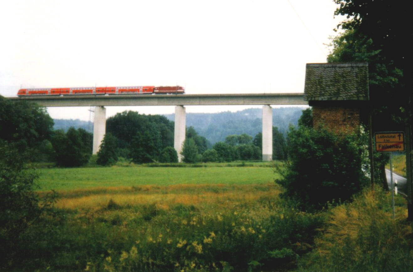
 New Hetzdorf Viaduct
Now begins a section with a number of viaducts. The first viaduct spans the Colmnitzbach in Colmnitz. In Niederbobritzsch, a town in the district of Bobritzsch, the line crosses the Bobritzsch river on a 26 metre high viaduct. After Muldenhütten station, the line crosses the 196 metres-long and 42.8 metres high viaduct over the Freiberger Mulde. At the 40.0 km mark the line reaches Freiberg station. It was formerly a major rail hub, but it is now only the end point for Dresden S-Bahn line S30 and the starting point of the branch line to Holzhau. This section and the Zellwaldbahn form the Nossen–Moldava (Moldau) line, which was restored to operation on 5 November 2005. The line branches off to the west of Freiberg station and runs north to Nossen. At this junction the line passes under federal highway 173 for the first time.
About 1.5 km east of Frankenstein station, in Wegefahrt, the line runs across one of the most impressive railway viaducts of the 19th century, the 348.5 metre-long and 39 metre-high Frankenstein viaduct, which crosses the valley of the Striegis. Shortly before Oederan the line passes under highway 173 again. Before Flöha the line connects with the branch line from Marienberg and Olbernhau. Until 1991 the line crossed the Flöha river on the old Hetzdorf Viaduct; it now runs along a new section with two prestressed concrete viaducts. After passing the junction with the Marienberg branch line and another line from Annaberg-Buchholz, the line reaches the town of Flöha and then crosses the Zschopau river. Niederwiesa, the second last stop before Chemnitz Hauptbahnhof for regional trains, is the beginning of a branch line to Hainichen. Chemnitz-Hilbersdorf station used to be the site of an important rail depot and one of the largest marshalling yards in Saxony; it is now closed. After connecting with two lines from the north, the line from Riesa and the line from Leipzig, the Dresden–Werdau line reaches Chemnitz Hauptbahnhof.
The line runs south from the station. After passing junctions with lines running south to Aue and to Stollberg, it turns to the west, running through the suburbs of Chemnitz and then starts to leave the wide basin of the Chemnitz river. Before Chemnitz-Siegmar, the line passes under the A 72. During the time of East Germany, the area west of Chemnitz was in the county of Hohenstein-Ernstthal, which was the most densely populated county in that country. Accordingly, the density of stations in the region is unusually high. After Hohenstein-Ernstthal the line passes under highway B 180 to reach St. Egidien station, where another line to Stollberg starts. At Glauchau the Mulden Valley Railway used to branch off, but almost all of it is now closed. At the next station, Glauchau-Schönbörnchen, the line to Gößnitz branches off; this is the beginning of the Mid-Germany Connection, a route linking to Weimar via Gera and Jena. The line now turns south and follows the course of the Zwickauer Mulde. The line passes through the town of Mosel, which is the location of a Volkswagen factory, and crosses the four-lane B 93 (and B 175) highway. After 128 km the line finally reaches Zwickau Hauptbahnhof. The line continues past the disused Zwickau marshalling yard for about five km west to Werdau arc triangle junction, which connects trains from Zwickau both to Leipzig via Werdau and to Nuremberg via Reichenbach. The line ends here, 135.96 km from Dresden.
References
- Heinrich, Rainer (2000). "Die Elektrifizierung des "Sächsischen Dreiecks"" (in German). Eisenbahn-Kurier 4 (337): 42–46. ISSN 0170-5288.
External links
- "Description of Saxon railway lines" (in German). http://www.sachsenschiene.de/. Retrieved 29 November 2010.
- "Photographs of tunnel portals" (in German). Tunnelportale. http://www.eisenbahn-tunnelportale.de/lb/inhalt/tunnelportale/6258.html. Retrieved 29 November 2010.
Categories:- Railway lines in Saxony
Wikimedia Foundation. 2010.