- Don Mot Daeng District
-
Don Mot Daeng
ดอนมดแดง— Amphoe — Amphoe location in Ubon Ratchathani Province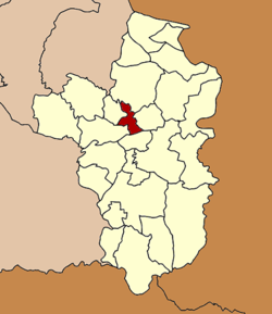
Coordinates: 15°22′44″N 105°1′38″E / 15.37889°N 105.02722°ECoordinates: 15°22′44″N 105°1′38″E / 15.37889°N 105.02722°E Country  Thailand
Province Ubon Ratchathani Seat Lao Daeng Tambon Muban Amphoe established Area - Total 234.0 km2 (90.3 sq mi) Population (2005) - Total 26,301 - Density 112.4/km2 (291.1/sq mi) Time zone THA (UTC+7) Postal code 34000 Geocode 3424 Don Mot Daeng (Thai: ดอนมดแดง) is a district (Amphoe) in the central part of Ubon Ratchathani Province, northeastern Thailand.
The district is named after the island Don Mot Daeng in the Mun River.
Contents
History
The area of the district was split off from Mueang Ubon Ratchathani district and formed a minor district (King Amphoe) on April 1 1991.[1] It was upgraded to a full district on December 5 1996.[2]
Geography
Neighboring districts are (from the east clockwise) Tan Sum, Sawang Wirawong, Mueang Ubon Ratchathani, Lao Suea Kok and Trakan Phuet Phon of Ubon Ratchathani Province.
The important water resources are the Mun and Se Bok River.
Administration
The district is subdivided into 4 subdistricts (tambon), which are further subdivided into 46 villages (muban). There are no municipal (thesaban) areas, and 4 Tambon administrative organizations (TAO).
No. Name Thai name Villages Inh. 1. Don Mot Daeng ดอนมดแดง 13 8,664 2. Lao Daeng เหล่าแดง 13 6,924 3. Tha Mueang ท่าเมือง 10 5,996 4. Kham Hai Yai คำไฮใหญ่ 10 4,717 References
- ^ "ประกาศกระทรวงมหาดไทย เรื่อง แบ่งเขตท้องที่อำเภอเมืองอุบลราชธานี จังหวัดอุบลราชธานี ตั้งเป็นกิ่งอำเภอดอนมดแดง" (in Thai). Royal Gazette 108 (15 ก): 1064. January 31 1991. http://www.ratchakitcha.soc.go.th/DATA/PDF/2534/D/015/1064.PDF.
- ^ "พระราชกฤษฎีกาตั้งอำเภอเหนือคลอง อำเภอนายายอาม อำเภอท่าตะเกียบ อำเภอขุนตาล อำเภอแม่ฟ้าหลวง อำเภอแม่ลาว อำเภอรัษฎา อำเภอพุทธมณฑล อำเภอวังน้ำเขียว อำเภอเจาะไอร้อง อำเภอชำนิ อำเภอโนนดินแดง อำเภอปางมะผ้า อำเภอสนธิ อำเภอหนองม่วง อำเภอเบญจลักษ์ อำเภอโพนนาแก้ว อำเภอบุ่งคล้า อำเภอดอนมดแดง และอำเภอลืออำนาจ พ.ศ. ๒๕๓๙" (in Thai). Royal Gazette 113 (62 ก): 5–8. November 20 1996. http://www.ratchakitcha.soc.go.th/DATA/PDF/2539/A/062/5.PDF.
External links
Mueang Ubon Ratchathani · Si Mueang Mai · Khong Chiam · Khueang Nai · Khemarat · Det Udom · Na Chaluai · Nam Yuen · Buntharik · Trakan Phuet Phon · Kut Khaopun · Muang Sam Sip · Warin Chamrap · Phibun Mangsahan · Tan Sum · Pho Sai · Samrong · Don Mot Daeng · Sirindhorn · Thung Si Udom · Na Yia · Na Tan · Lao Suea Kok · Sawang Wirawong · Nam Khun
Categories:- Amphoe of Ubon Ratchathani
- Isan geography stubs

Wikimedia Foundation. 2010.