- Deline
-
Deline
Délįne— Settlement Corporation —  Great Bear Lake, NWT, Canada
 Location of Deline within Canada
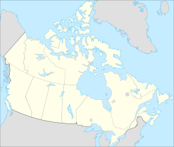
 Deline
Coordinates: 65°11′12″N 123°25′18″W / 65.186667°N 123.421667°WCoordinates: 65°11′12″N 123°25′18″W / 65.186667°N 123.421667°W Country  Canada
Territory  Northwest Territories
Region Sahtu Region Constituency Sahtu Census division Inuvik Region, Northwest Territories Charter Community 1 April 1993 Government - Ehk'Wahtide Raymond Tutcho - Senior Administrative Officer Christina Gaudet - MLA Norman Yakeleya Area - Land 79.33 km2 (30.6 sq mi) Elevation 214 m (702 ft) Population - Total 525 - Density 6.6/km2 (17.1/sq mi) Time zone Mountain (MST) (UTC-7) - Summer (DST) MDT (UTC-6) Canadian Postal code X0E 0G0 Area code(s) 867 Telephone exchange 589 Prices - Living cost 162.5A - Food price index 191.4B Website www.deline.ca Sources:Community Governance Data List[1],
2006 Canada Census[2],
Prince of Wales Northern Heritage Centre[3],
Délįne profile at the Legislative Assembly[4]
Canada Flight Supplement[5]
^A 2005 figure based on Edmonton = 100[6]
^B 2004 figure based on Yellowknife = 100[6]The Charter Community of Délįne is located in the Sahtu Region of the Northwest Territories, Canada on the western shore of Great Bear Lake and is 544 km (338 mi) northwest of Yellowknife. Délįne means "where the waters flow", a reference to the headwaters of the Great Bear River, Sahtúdé.
The population as of the 2006 Census was 525,[2] mainly Sahtu Dene people speaking North Slavey.[7] In 2009 the Government of the Northwest Territories reported that the population was 565 with an average yearly growth rate of -1.0 from 1996.[6]
Contents
Pitchblende
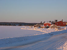 On the shores of Great Bear Lake
The area became prominent when pitchblende was discovered at the Eldorado Mine, some 250 km (160 mi) away, on the eastern shore, at Port Radium. During World War II, the Canadian government took over the mine and began to produce uranium for the then-secret American nuclear bomb project. The town became a permanent settlement in 1952 with the building of a school.
The Dene from Délįne, who were conscripted as ore carriers, were not informed about the risks of radioactivity or how to protect themselves. Most of those men who participated began to die of cancer in the 1960s.
According to oral history, while canoeing on Great Bear Lake in the early part of the 20th century, a Délįne elder reached a precipice where he had a vision of a great city burning, of people who comported First Nations features enduring great suffering. According to tradition, this precipice is where uranium was later discovered.
John Franklin
Originally called Fort Franklin (until 1 June 1993), it was constructed by Peter Warren Dease of the Hudson's Bay Company as the staging area and winter quarters for Sir John Franklin's second Arctic expedition. It was constructed at one of the most productive Dene fisheries in the Mackenzie River drainage basin.
The original fort was excavated by the Prince of Wales Northern Heritage Centre in 1987. The excavation uncovered beads, rings, and buttons indicating the extent of trade between the Dene and Europeans. The site is protected by the Northwest Territories Archaeological Sites Regulations.
Land claims
Délįne is represented by the Deline First Nation and belong to the Sahtu Dene Council.[8] Through the council they are in negotiations with the Government of Canada for a land claims settlement.
Polar bears
On 2 April 2008 three polar bears, a mother and two cubs, were seen in the community, which is 480 kilometres (300 mi) south of the Arctic Ocean. The bears, which were harassing dogs, and posed a danger to local people were shot by a member of the Royal Canadian Mounted Police due to the lack of wildlife officers with tranquillisers. A biologist with the Government of the NWT took samples from the bears, which are marine mammals and usually remain near the ocean. The biologist stated that the animals were starving and that they were unable to take fat samples and their muscles were starting to break down. A biologist with the University of Alberta said that the unusual sighting was "...probably an indication of something changing broadly over an ecosystem,".[9][10]
Demographics
Historical populations Year Pop. %± 1996 645 – 1997 636 -1.4% 1998 615 -3.3% 1999 599 -2.6% 2000 568 -5.2% 2001 566 -0.4% 2002 550 -2.8% 2003 556 1.1% 2004 546 -1.8% 2005 545 -0.2% 2006 545 0.0% 2007 551 1.1% 2008 565 2.5% 2009 565 0.0% Sources: NWT Bureau of Statistics[6] See also
References
- ^ Community Governance Data List
- ^ a b 2006 Census
- ^ Prince of Wales Northern Heritage Centre - official names
- ^ Legislative Assembly of the Northwest Territories, Délįne profile
- ^ Canada Flight Supplement. Effective 0901Z 20 October 2011 to 0901Z 15 December 2011
- ^ a b c d Deline - Statistical Profile at the GNWT
- ^ 2001 Census
- ^ Indian and Northern Affairs Canada
- ^ News/North online and print edition
- ^ Wandering polar bears a sign of climate change: expert
- John Price, "Our own atomic victims," Victoria Times-Colonist
External links
- Municipal Affairs and Community Administration profile
- Welcome to Délįne
- Village of Widows
- Prince of Wales Northern Heritage Center
 Subdivisions of the Northwest Territories
Census divisions Dehcho Region Inuvik Region Aklavik · Fort McPherson · Inuvik · Paulatuk · Sachs Harbour · Tsiigehtchic · Tuktoyaktuk · UlukhaktokNorth Slave Region Sahtu Region South Slave Region Enterprise · Fort Providence · Fort Resolution · Fort Smith · Hay River Reserve · Hay River · Kakisa Category:Northwest Territories ·
  Portal:Northwest Territories ·
  WikiProject:Canadian TerritoriesCategories:
- Communities in the Sahtu Region
- Mining communities in the Northwest Territories
- Dene communities
- Hudson's Bay Company forts


Wikimedia Foundation. 2010.