- Deception Pass ferry
-
Deception Pass Ferry 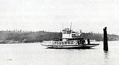
Motor ferry Deception Pass Service Type 5 minutes Frequency hourly, 7:30 am to 7:30 pm. History Closed 1935 Successor Deception Pass Bridge The Deception Pass ferry was a ferry route in Washington State that ran between Fidalgo Island and Whidbey Island across Deception Pass.
Contents
History
From 1924 to 1935, the route was run by Berte H. Olson (1882-1959), and her husband, O.A. Olson, who held a state highway contract. Berte Olson was the first woman to hold a ferry captain's license in Washington state.[1]
The Olsons had a ferry built specifically for the route. This was the Ballard Marine Yard in June, 1924. The fee for car and driver was 50 cents, with 10 cents additional for every extra passenger, with "extra large" cars paying 75 cents. Service was hourly, and the transit time was only five minutes. Patrons were cautioned that the schedule was "subject to storms, breakdowns, and conditions beyond our control."[1]
Discontinuation
The route was discontinued when the Deception Pass Bridge was completed in 1935.[1] For years, Berte Olson fought a political struggle against the bridge, even persuading Governor Roland Hartley to veto a funding bill that had been unanimously passed by the Washington State legislature in 1929. Eventually she was defeated, but she became known as a strong-willed person.[2]
Notes
- ^ a b c Kline and Bayless, Ferryboats – A Legend on Puget Sound, at pages 147-48, 337 and 361.
- ^ Long, Priscella, Deception Pass and Canoe Pass bridges are dedicated on July 31, 1935.HistoryLink.org Essay 5698, May 5, 2004
References
- Long, Priscella, Deception Pass and Canoe Pass bridges are dedicated on July 31, 1935.HistoryLink.org Essay 5698, May 5, 2004
- Kline, Mary S., and Bayless, G.A., Ferryboats -- A Legend on Puget Sound, Bayless Books, Seattle, WA 1983 ISBN 0-914515-00-4
- Newell, Gordon R. ed., H.W. McCurdy Marine History of the Pacific Northwest, Superior Publishing, Seattle WA 1966 ISBN 0875642209
Categories:- Ferry routes in western Washington (state)
- Transportation in Skagit County, Washington
- History of Skagit County, Washington
- Transportation in Island County, Washington
- History of Island County, Washington

Wikimedia Foundation. 2010.