Cow Yard Brook (New Jersey)

Cow Yard Brook (New Jersey)
Cow Yard Brook

Cow Yard Brook crossing Deans Lane
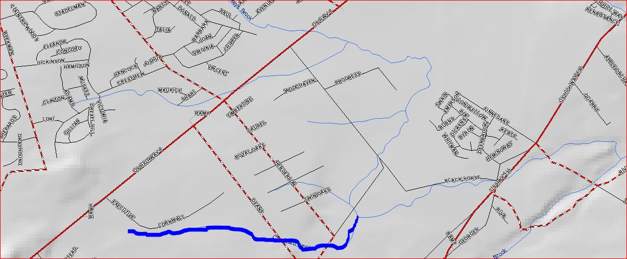
Map of Cow Yard Brook
Origin 40°24′43″N 74°32′8″W / 40.41194°N 74.53556°W / 40.41194; -74.53556
Mouth 40°24′46″N 74°30′51″W / 40.41278°N 74.51417°W / 40.41278; -74.51417
Progression Oakeys Brook, Lawrence Brook, Raritan River, Atlantic Ocean
Basin countries United States
Mouth elevation 98 ft (30 m)

The Cow Yard Brook is a small tributary of the Oakeys Brook, in central South Brunswick, New Jersey in the United States.

Contents

Course

The Cow Yard Brook starts at 40°24′43″N 74°32′8″W / 40.41194°N 74.53556°W / 40.41194; -74.53556[1] near the intersection of Beekman Road, Northumberland Way, and Route 1. It crosses Deans Lane near its intersection with Black Horse Lane. It then crosses Black Horse Lane and drains into the Oakeys Brook at 40°24′46″N 74°30′51″W / 40.41278°N 74.51417°W / 40.41278; -74.51417[1], near the intersection of Black Horse Lane and Henderson Road.

Accessibility

The Cow Yard Brook is very short, but it can be accessed by some of the roads it crosses and the Oakeys Brook.

Gallery

See also

References

  1. ^ a b "USGS GNIS - Cow Yard Brook". USGS. http://gnis.usgs.gov/pls/gnispublic/f?p=139:3:720256407154093::NO:3:P3_FID,P3_TITLE:875679%2CCow%20Yard%20Brook. Retrieved 14 June 2010. 

External links


Wikimedia Foundation. 2010.

Игры ⚽ Поможем сделать НИР

Look at other dictionaries:

  • Oakeys Brook (New Jersey) — Oakeys Brook Oakeys Brook near Brunswick Acres School in North Brunswick …   Wikipedia

  • List of rivers of New Jersey — This is a list of streams and rivers in the U.S. state of New Jersey. List of New Jersey rivers includes streams formally designated as rivers. There are also smaller streams (i.e., branches, creeks, drains, forks, licks, runs, etc.) in the state …   Wikipedia

  • Lawrence Brook — One of the few undammed sections of Lawrence Brook (below Davidsons Mill Pond) Origin …   Wikipedia

  • Boston Navy Yard — Boston Naval Shipyard U.S. National Register of Historic Places U.S. National Historic Landmark District …   Wikipedia

  • environment — environmental, adj. environmentally, adv. /en vuy reuhn meuhnt, vuy euhrn /, n. 1. the aggregate of surrounding things, conditions, or influences; surroundings; milieu. 2. Ecol. the air, water, minerals, organisms, and all other external factors… …   Universalium

  • Bridgeport, Connecticut — Bridgeport redirects here. For other uses, see Bridgeport (disambiguation). City of Bridgeport   City   …   Wikipedia

  • Massachusetts Military Reservation — Coordinates: 41°42′15″N 70°32′30″W / 41.70417°N 70.54167°W / 41.70417; 70.54167 The Massachusetts Military Reservation …   Wikipedia

  • Cambridge, Massachusetts — Not to be confused with Cambridge, United Kingdom. Cambridge, Massachusetts   City   Cambridge City Hall …   Wikipedia

  • Otis Air National Guard Base — Coast Guard Air Station Cape Cod Part of Massachusetts Air National Guard (MA ANG) Located near: Mashpee, Massachusetts …   Wikipedia

  • Nantucket Memorial Airport — IATA: ACK – ICAO: KACK – FAA LID: ACK Summary Airport type Public Owner Town of Nantucket …   Wikipedia

Share the article and excerpts

Direct link
Do a right-click on the link above
and select “Copy Link”