Stapylton County

Stapylton County
Stapylton
New South Wales
Stapylton NSW.PNG
Location in New South Wales
Lands administrative divisions around Stapylton
Carnarvon (Qld) Carnarvon (Qld) Marsh (Qld)
Benarba Stapylton Arrawatta
Benarba Courallie Burnett

Stapylton County is one of the 141 Cadastral divisions of New South Wales. It is located to the south of the Barwon River and includes part of the Newell Highway.

Stapylton County was named in honour of the geologist Granville William Chetwynd Stapylton (1800-1840).[1]

Parishes

A full list of parishes found within this county; their current LGA and mapping coordinates to the approximate centre of each location is as follows:

Parish LGA Coordinates
Adams Moree Plains Shire 29°04′54″S 149°51′04″E / 29.08167°S 149.85111°E / -29.08167; 149.85111 (Adams Parish)
Bengerang Moree Plains Shire 29°04′54″S 149°31′04″E / 29.08167°S 149.51778°E / -29.08167; 149.51778 (Bengerang Parish)
Benson Moree Plains Shire 29°13′54″S 149°49′04″E / 29.23167°S 149.81778°E / -29.23167; 149.81778 (Benson Parish)
Blue Nobby Gwydir Shire 29°55′54″S 150°38′04″E / 29.93167°S 150.63444°E / -29.93167; 150.63444 (Blue Nobby Parish)
Boggabilla Moree Plains Shire 28°34′54″S 150°17′04″E / 28.58167°S 150.28444°E / -28.58167; 150.28444 (Boggabilla Parish)
Boobera Moree Plains Shire 28°37′54″S 150°08′04″E / 28.63167°S 150.13444°E / -28.63167; 150.13444 (Boobera Parish)
Boonal Gwydir Shire 29°45′54″S 150°32′04″E / 29.765°S 150.53444°E / -29.765; 150.53444 (Boonal Parish)
Boonanga Gwydir Shire 28°50′54″S 150°28′04″E / 28.84833°S 150.46778°E / -28.84833; 150.46778 (Boonanga Parish)
Booraba Gwydir Shire 29°00′54″S 150°23′04″E / 29.015°S 150.38444°E / -29.015; 150.38444 (Booraba Parish)
Browne Moree Plains Shire 28°42′54″S 150°13′04″E / 28.715°S 150.21778°E / -28.715; 150.21778 (Browne Parish)
Bryanungra Moree Plains Shire 29°05′54″S 149°57′04″E / 29.09833°S 149.95111°E / -29.09833; 149.95111 (Bryanungra Parish)
Canary Moree Plains Shire 28°39′54″S 149°52′04″E / 28.665°S 149.86778°E / -28.665; 149.86778 (Canary Parish)
Careunga Moree Plains Shire 29°00′54″S 150°00′04″E / 29.015°S 150.00111°E / -29.015; 150.00111 (Careunga Parish)
Careunga North Moree Plains Shire 28°54′54″S 149°55′04″E / 28.915°S 149.91778°E / -28.915; 149.91778 (Careunga North Parish)
Carroby Moree Plains Shire 28°38′54″S 150°01′04″E / 28.64833°S 150.01778°E / -28.64833; 150.01778 (Carroby Parish)
Cook Moree Plains Shire 28°46′54″S 150°19′04″E / 28.78167°S 150.31778°E / -28.78167; 150.31778 (Cook Parish)
Coolanga Moree Plains Shire 28°49′54″S 150°10′04″E / 28.83167°S 150.16778°E / -28.83167; 150.16778 (Coolanga Parish)
Coppymurrumbill Moree Plains Shire 28°48′54″S 150°17′04″E / 28.815°S 150.28444°E / -28.815; 150.28444 (Coppymurrumbill Parish)
Currumbah Moree Plains Shire 28°53′54″S 150°10′04″E / 28.89833°S 150.16778°E / -28.89833; 150.16778 (Currumbah Parish)
Denebry Moree Plains Shire 29°12′54″S 150°01′04″E / 29.215°S 150.01778°E / -29.215; 150.01778 (Denebry Parish)
Douro Moree Plains Shire 29°04′54″S 149°46′04″E / 29.08167°S 149.76778°E / -29.08167; 149.76778 (Douro Parish)
Finley Moree Plains Shire 29°00′54″S 149°46′04″E / 29.015°S 149.76778°E / -29.015; 149.76778 (Finley Parish)
Gil Gil Moree Plains Shire 29°08′54″S 150°12′04″E / 29.14833°S 150.20111°E / -29.14833; 150.20111 (Gil Gil Parish)
Goorara Moree Plains Shire 29°04′54″S 149°35′04″E / 29.08167°S 149.58444°E / -29.08167; 149.58444 (Goorara Parish)
Gunnyanna Moree Plains Shire 29°01′54″S 149°41′04″E / 29.03167°S 149.68444°E / -29.03167; 149.68444 (Gunnyanna Parish)
Harvey Moree Plains Shire 29°16′54″S 150°02′04″E / 29.28167°S 150.03444°E / -29.28167; 150.03444 (Harvey Parish)
Holmes Gwydir Shire 28°59′54″S 150°18′04″E / 28.99833°S 150.30111°E / -28.99833; 150.30111 (Holmes Parish)
Illingrammindi Moree Plains Shire 28°50′54″S 150°00′04″E / 28.84833°S 150.00111°E / -28.84833; 150.00111 (Illingrammindi Parish)
Kinnimo Moree Plains Shire 28°55′54″S 149°42′04″E / 28.93167°S 149.70111°E / -28.93167; 149.70111 (Kinnimo Parish)
Lay Green Moree Plains Shire 29°03′54″S 150°12′04″E / 29.065°S 150.20111°E / -29.065; 150.20111 (Lay Green Parish)
Limebon Moree Plains Shire 28°46′54″S 150°05′04″E / 28.78167°S 150.08444°E / -28.78167; 150.08444 (Limebon Parish)
Mayne Moree Plains Shire 28°40′54″S 150°18′04″E / 28.68167°S 150.30111°E / -28.68167; 150.30111 (Mayne Parish)
Melleallina Moree Plains Shire 29°10′54″S 149°54′04″E / 29.18167°S 149.90111°E / -29.18167; 149.90111 (Melleallina Parish)
Merriwa Moree Plains Shire 28°56′54″S 150°24′04″E / 28.94833°S 150.40111°E / -28.94833; 150.40111 (Merriwa Parish)
Mingan Gwydir Shire 28°51′54″S 150°24′04″E / 28.865°S 150.40111°E / -28.865; 150.40111 (Mingan Parish)
Mobbindry Moree Plains Shire 28°47′54″S 150°24′04″E / 28.79833°S 150.40111°E / -28.79833; 150.40111 (Mobbindry Parish)
Moppin Moree Plains Shire 29°11′54″S 149°42′04″E / 29.19833°S 149.70111°E / -29.19833; 149.70111 (Moppin Parish)
Morella Moree Plains Shire 28°39′54″S 150°15′04″E / 28.665°S 150.25111°E / -28.665; 150.25111 (Morella Parish)
Mount Pleasant Moree Plains Shire 29°03′54″S 150°04′04″E / 29.065°S 150.06778°E / -29.065; 150.06778 (Mount Pleasant Parish)
Mungle Gwydir Shire 28°52′54″S 150°16′04″E / 28.88167°S 150.26778°E / -28.88167; 150.26778 (Mungle Parish)
Paine Moree Plains Shire 28°59′54″S 150°02′04″E / 28.99833°S 150.03444°E / -28.99833; 150.03444 (Paine Parish)
Paleranga Moree Plains Shire 28°40′54″S 149°45′04″E / 28.68167°S 149.75111°E / -28.68167; 149.75111 (Paleranga Parish)
Stapylton Gwydir Shire 28°59′54″S 150°30′04″E / 28.99833°S 150.50111°E / -28.99833; 150.50111 (Stapylton Parish)
Tantarana Moree Plains Shire 29°14′54″S 150°06′04″E / 29.24833°S 150.10111°E / -29.24833; 150.10111 (Tantarana Parish)
Toongcooma Moree Plains Shire 28°59′54″S 150°13′04″E / 28.99833°S 150.21778°E / -28.99833; 150.21778 (Toongcooma Parish)
Trinkey Moree Plains Shire 28°38′54″S 150°02′04″E / 28.64833°S 150.03444°E / -28.64833; 150.03444 (Trinkey Parish)
Tubble Gah Gwydir Shire 29°51′54″S 150°37′04″E / 29.865°S 150.61778°E / -29.865; 150.61778 (Tubble Gah Parish)
Tucka Tucka Gwydir Shire 29°45′54″S 150°37′04″E / 29.765°S 150.61778°E / -29.765; 150.61778 (Tucka Tucka Parish)
Tulloona Moree Plains Shire 28°52′54″S 150°04′04″E / 28.88167°S 150.06778°E / -28.88167; 150.06778 (Tulloona Parish)
Tun Cooey Moree Plains Shire 29°08′54″S 150°05′04″E / 29.14833°S 150.08444°E / -29.14833; 150.08444 (Tun Cooey Parish)
Wallon Moree Plains Shire 29°13′54″S 149°55′04″E / 29.23167°S 149.91778°E / -29.23167; 149.91778 (Wallon Parish)
Warra Warrama Moree Plains Shire 29°00′54″S 150°07′04″E / 29.015°S 150.11778°E / -29.015; 150.11778 (Warra Warrama Parish)
Welbon Moree Plains Shire 29°09′54″S 149°45′04″E / 29.165°S 149.75111°E / -29.165; 149.75111 (Welbon Parish)
Whalan Moree Plains Shire 28°45′54″S 150°24′04″E / 28.765°S 150.40111°E / -28.765; 150.40111 (Whalan Parish)
Willimill Moree Plains Shire 28°48′54″S 149°46′04″E / 28.815°S 149.76778°E / -28.815; 149.76778 (Willimill Parish)
Wonga Moree Plains Shire 28°46′54″S 150°13′04″E / 28.78167°S 150.21778°E / -28.78167; 150.21778 (Wonga Parish)
Yooloobil Moree Plains Shire 28°47′54″S 149°54′04″E / 28.79833°S 149.90111°E / -28.79833; 149.90111 (Yooloobil Parish)

References

  1. ^ [acms.sl.nsw.gov.au/item/itemDetailPaged.aspx?itemID=432528 - 58k

Wikimedia Foundation. 2010.

Игры ⚽ Поможем написать курсовую

Look at other dictionaries:

  • Stapylton County, New South Wales — Infobox Australian cadastral name = Stapylton state = New South Wales caption = Location in New South Wales near nw = Queensland near n = Queensland near ne = Queensland near e = Arrawatta near se = Burnett near s = Courallie near sw = Benarba… …   Wikipedia

  • County of Stanley, Queensland — Map of all coordinates from Google Map of all coordinates from Bing Export all coordinates as KML …   Wikipedia

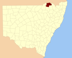
  • Burnett County, New South Wales — Infobox Australian cadastral name = Burnett state = New South Wales caption = Location in New South Wales near nw = Stapylton near n = Stapylton near ne = Arrawatta near e = Arrawatta near se = Arrawatta near s = Murchison near sw = Courallie… …   Wikipedia

  • John Stapylton Habgood — John Stapylton Habgood, Baron Habgood PC (* 23. Juni 1927 in Stony Stratford) war von 1973 bis 1983 Bischof von Durham und von 1983 bis 1995 Erzbischof von York. Er ist als Life Peer Abgeordneter im britischen Oberhaus. Inhaltsverzeichnis 1 Leben …   Deutsch Wikipedia

  • Arrawatta County, New South Wales — Infobox Australian cadastral name = Arrawatta state = New South Wales caption = Location in New South Wales near nw = Stapylton near n = Queensland near ne = Queensland near w = Burnett near e = Clive near sw = Murchison near s = Hardinge near se …   Wikipedia

  • Benarba County, New South Wales — Infobox Australian cadastral name = Benarba state = New South Wales caption = Location in New South Wales near nw = Queensland near n = Queensland near ne = Stapylton near w = Finch near e = Courallie near sw = Denham near s = Jamison near se =… …   Wikipedia

  • Courallie County, New South Wales — Infobox Australian cadastral name = Courallie state = New South Wales caption = Location in New South Wales near nw = Benarba near n = Stapylton near ne = Burnett near e = Burnett near se = Murchison near s = Jamison near sw = Jamison near w =… …   Wikipedia

  • Arrawatta County — Map of all coordinates from Google Map of all coordinates from Bing Export all coordinates as KML …   Wikipedia

  • Benarba County — Map of all coordinates from Google Map of all coordinates from Bing Export all coordinates as KML …   Wikipedia

  • Courallie County — Map of all coordinates from Google Map of all coordinates from Bing Export all coordinates as KML …   Wikipedia

Share the article and excerpts

Direct link
Do a right-click on the link above
and select “Copy Link”