Bligh County

Bligh County
Bligh
New South Wales
Bligh NSW.PNG
Location in New South Wales
Lands administrative divisions around Bligh
Napier Pottinger Buckland
Lincoln Bligh Brisbane
Gordon Wellington Phillip

Bligh County was one of the original Nineteen Counties in New South Wales and is now one of the 141 Cadastral divisions of New South Wales. The Cudgegong River and the Goulburn River are its southern boundaries; the Krui River is the eastern boundary, and the Burragundy River the northern boundary. It includes the villages of Cassilis and Dunedoo.

The county was named after William Bligh, Admiral and Governor of New South Wales (1805-1808).[1] The Electoral district of Phillip, Brisbane and Bligh was the first electoral district for the area, between 1856 and 1859.

Parishes within this county

A full list of parishes found within this county; their current LGA and mapping coordinates to the approximate centre of each location is as follows:

Parish LGA Coordinates
Bellaleppa Upper Hunter Shire 32°01′54″S 150°07′04″E / 32.03167°S 150.11778°E / -32.03167; 150.11778 (Bellaleppa)
Berenderry Upper Hunter Shire 32°00′54″S 150°10′04″E / 32.015°S 150.16778°E / -32.015; 150.16778 (Berenderry)
Bligh Mid-Western Regional Council 32°09′54″S 149°42′04″E / 32.165°S 149.70111°E / -32.165; 149.70111 (Bligh)
Bobadeen Mid-Western Regional Council 32°10′54″S 149°48′04″E / 32.18167°S 149.80111°E / -32.18167; 149.80111 (Bobadeen)
Booyamurna Warrumbungle Shire 31°47′54″S 149°50′04″E / 31.79833°S 149.83444°E / -31.79833; 149.83444 (Booyamurna)
Borambil Upper Hunter Shire 32°02′54″S 150°02′04″E / 32.04833°S 150.03444°E / -32.04833; 150.03444 (Borambil)
Bowman Warrumbungle Shire 32°03′54″S 149°37′04″E / 32.065°S 149.61778°E / -32.065; 149.61778 (Bowman)
Bulga Upper Hunter Shire 31°52′54″S 149°59′04″E / 31.88167°S 149.98444°E / -31.88167; 149.98444 (Bulga)
Bungaba Mid-Western Regional Council 32°09′54″S 149°38′04″E / 32.165°S 149.63444°E / -32.165; 149.63444 (Bungaba)
Collaroy Upper Hunter Shire 32°02′54″S 150°01′04″E / 32.04833°S 150.01778°E / -32.04833; 150.01778 (Collaroy)
Collieblue Warrumbungle Shire 31°51′54″S 149°46′04″E / 31.865°S 149.76778°E / -31.865; 149.76778 (Collieblue)
Collier Warrumbungle Shire 31°55′54″S 149°45′04″E / 31.93167°S 149.75111°E / -31.93167; 149.75111 (Collier)
Cope Mid-Western Regional Council 32°16′54″S 149°39′04″E / 32.28167°S 149.65111°E / -32.28167; 149.65111 (Cope)
Cunna Upper Hunter Shire 31°47′49″S 150°05′47″E / 31.79694°S 150.09639°E / -31.79694; 150.09639 (Cunna)
Curryall Upper Hunter Shire 32°04′54″S 149°50′04″E / 32.08167°S 149.83444°E / -32.08167; 149.83444 (Curryall)
Doulagunmala Upper Hunter Shire 31°56′54″S 150°00′04″E / 31.94833°S 150.00111°E / -31.94833; 150.00111 (Doulagunmala)
Durridgere Mid-Western Regional Council 32°10′54″S 149°53′04″E / 32.18167°S 149.88444°E / -32.18167; 149.88444 (Durridgere)
Goodiman Mid-Western Regional Council 32°12′54″S 149°23′04″E / 32.215°S 149.38444°E / -32.215; 149.38444 (Goodiman)
Goolma Mid-Western Regional Council 32°18′54″S 149°16′04″E / 32.315°S 149.26778°E / -32.315; 149.26778 (Goolma)
Guroba Wellington Council 32°29′24″S 149°14′04″E / 32.49°S 149.23444°E / -32.49; 149.23444 (Guroba)
Lorimer Upper Hunter Shire 31°54′54″S 150°13′04″E / 31.915°S 150.21778°E / -31.915; 150.21778 (Lorimer)
Merotherie Mid-Western Regional Council 32°08′54″S 149°29′04″E / 32.14833°S 149.48444°E / -32.14833; 149.48444 (Merotherie)
Moan Upper Hunter Shire 31°51′10″S 150°09′48″E / 31.85278°S 150.16333°E / -31.85278; 150.16333 (Moan)
Munmurra Mid-Western Regional Council 32°10′54″S 150°01′04″E / 32.18167°S 150.01778°E / -32.18167; 150.01778 (Munmurra)
Nagora Upper Hunter Shire 31°53′54″S 150°05′04″E / 31.89833°S 150.08444°E / -31.89833; 150.08444 (Nagora)
Nandoura Warrumbungle Shire 32°02′54″S 149°48′04″E / 32.04833°S 149.80111°E / -32.04833; 149.80111 (Nandoura)
Nanima Wellington Council 32°29′54″S 148°59′04″E / 32.49833°S 148.98444°E / -32.49833; 148.98444 (Nanima)
Narragamba Mid-Western Regional Council 32°10′54″S 149°35′04″E / 32.18167°S 149.58444°E / -32.18167; 149.58444 (Narragamba)
Puggoon Mid-Western Regional Council 32°17′54″S 149°27′04″E / 32.29833°S 149.45111°E / -32.29833; 149.45111 (Puggoon)
Rotherwood Warrumbungle Shire 31°49′54″S 150°01′04″E / 31.83167°S 150.01778°E / -31.83167; 150.01778 (Rotherwood)
Rotherwood Warrumbungle Shire 31°52′24″S 149°53′04″E / 31.87333°S 149.88444°E / -31.87333; 149.88444 (Rotherwood)
Rouse Mid-Western Regional Council 32°08′54″S 149°26′04″E / 32.14833°S 149.43444°E / -32.14833; 149.43444 (Rouse)
Stubbo Mid-Western Regional Council 32°17′54″S 149°34′04″E / 32.29833°S 149.56778°E / -32.29833; 149.56778 (Stubbo)
Talbragar Warrumbungle Shire 32°01′54″S 149°33′04″E / 32.03167°S 149.55111°E / -32.03167; 149.55111 (Talbragar)
Tallawang Mid-Western Regional Council 32°12′54″S 149°28′04″E / 32.215°S 149.46778°E / -32.215; 149.46778 (Tallawang)
Terraban Warrumbungle Shire 31°59′54″S 149°39′04″E / 31.99833°S 149.65111°E / -31.99833; 149.65111 (Terraban)
Tomimbil [[Upper Hunter Shire] 32°06′54″S 150°00′04″E / 32.115°S 150.00111°E / -32.115; 150.00111 (Tomimbil)
Turee Warrumbungle Shire 31°58′54″S 149°50′04″E / 31.98167°S 149.83444°E / -31.98167; 149.83444 (Turee)
Turill Upper Hunter Shire 32°01′54″S 149°56′04″E / 32.03167°S 149.93444°E / -32.03167; 149.93444 (Turill)
Uarbry Warrumbungle Shire 32°02′54″S 149°45′04″E / 32.04833°S 149.75111°E / -32.04833; 149.75111 (Uarbry)
Ulan Mid-Western Regional Council 32°14′54″S 149°44′04″E / 32.24833°S 149.73444°E / -32.24833; 149.73444 (Ulan)
Wargundy Warrumbungle Shire 32°02′54″S 149°27′04″E / 32.04833°S 149.45111°E / -32.04833; 149.45111 (Wargundy)
Warung Warrumbungle Shire 31°45′54″S 150°03′04″E / 31.765°S 150.05111°E / -31.765; 150.05111 (Warung)
Wondaby Wellington Council 32°26′54″S 149°12′04″E / 32.44833°S 149.20111°E / -32.44833; 149.20111 (Wondaby)
Worobil Mid-Western Regional Council 32°22′54″S 149°13′04″E / 32.38167°S 149.21778°E / -32.38167; 149.21778 (Worobil)
Wuuluman Wellington Council 32°29′24″S 149°10′04″E / 32.49°S 149.16778°E / -32.49; 149.16778 (Wuuluman)
Yarragal Wellington Council 32°35′54″S 149°06′04″E / 32.59833°S 149.10111°E / -32.59833; 149.10111 (Yarragal)
Yarrobil Mid-Western Regional Council 32°19′54″S 149°21′04″E / 32.33167°S 149.35111°E / -32.33167; 149.35111 (Yarrobil)

References


Wikimedia Foundation. 2010.

Игры ⚽ Нужно сделать НИР?

Look at other dictionaries:

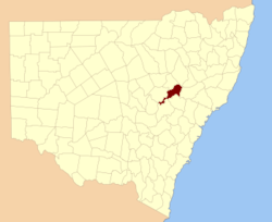
  • Bligh County, New South Wales — Infobox Australian cadastral name = Bligh state = New South Wales caption = Location in New South Wales near nw = Napier near n = Pottinger near ne = Buckland near e = Brisbane near se = Phillip near s = Wellington near sw = Gordon near w =… …   Wikipedia

  • Bligh —   [blaɪ], William, britischer Seeoffizier, * Tyntan im County Cornwall (nach anderen Angaben Plymouth) 9. 9. 1754, ✝ London 7. 12. 1817; nahm an der zweiten Expedition von J. Cook (1772 75) teil und war auf dessen dritter Reise (1776 79/80)… …   Universal-Lexikon

  • Bligh, William — born Sept. 9, 1754, county of Cornwall, Eng. died Dec. 7, 1817, London English admiral. He went to sea at the age of seven and joined the Royal Navy in 1770. After serving as the sailing master on Capt. James Cook s final voyage (1776–80), he was …   Universalium

  • Electoral district of Wellington and Bligh — Wellington and Bligh was an electoral district of the Legislative Assembly in the Australian state of New South Wales, named after Wellington County and Bligh County, and including Mudgee. There were also separate electoral districts of… …   Wikipedia

  • Ivo Bligh, 8th Earl of Darnley — Infobox cricketer biography playername = Ivo Bligh country = England fullname = Ivo Francis Walter Bligh dayofbirth = 13 monthofbirth = 3 yearofbirth = 1859 placeofbirth = Westminster, London countryofbirth = England dayofdeath = 10 monthofdeath …   Wikipedia

  • Lincoln County, New South Wales — Infobox Australian cadastral name = Lincoln state = New South Wales caption = Location in New South Wales near nw = Ewenmar near n = Gowen near ne = Napier near e = Bligh near se = Bligh near s = Bligh near sw = Gordon near w = Narromine Lincoln… …   Wikipedia

  • Edward Bligh — The Honourable Edward Bligh (19 September 1769 ndash; 2 November 1840), was a noted amateur cricketer and a prominent early member of MCC. Bligh was born in County Meath, Ireland. He was a brother of the 4th Earl of Darnley (1767 1831). The 4th… …   Wikipedia

  • Brisbane County, New South Wales — Infobox Australian cadastral name = Brisbane state = New South Wales caption = Location in New South Wales near nw = Pottinger near n = Buckland near ne = Parry near e = Hawes near se = Durham near s = Hunter near sw = Phillip near w =… …   Wikipedia

  • Phillip County, New South Wales — Infobox Australian cadastral name = Phillip state = New South Wales caption = Location in New South Wales near nw = Bligh near n = Brisbane near ne = Brisbane near e = Hunter near se = Hunter near s = Roxburgh near sw = Wellington near w =… …   Wikipedia

  • Brisbane County — Map of all coordinates from Google Map of all coordinates from Bing Export all coordinates as KML …   Wikipedia

Share the article and excerpts

Direct link
Do a right-click on the link above
and select “Copy Link”