- COSCO Busan oil spill
-
COSCO Busan oil spill 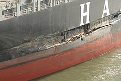
The damaged MV COSCO Busan after striking the bridge tower fenderLocation San Francisco Bay Coordinates 37°48′03″N 122°22′29″W / 37.80073°N 122.37486°WCoordinates: 37°48′03″N 122°22′29″W / 37.80073°N 122.37486°W Date 7 November 2007 Cause Cause COSCO Busan collision with the San Francisco – Oakland Bay Bridge in thick fog. Operator COSCO Busan Spill characteristics Volume 53,569 USgal (202,780 l; 44,606 imp gal) Area 150 sq mi (390 km2) Shoreline impacted 26 mi (42 km) The COSCO Busan oil spill occurred at 08:30 UTC-8 on 7 November 2007 between San Francisco and Oakland, California, in which 53,569 USgal (202,780 l) of IFO-380 heavy fuel oil, sometimes referred to as "bunker fuel", spilled into San Francisco Bay after the container ship M/V COSCO Busan operated by, Fleet Management Ltd., struck Delta Tower of the San Francisco – Oakland Bay Bridge in thick fog.
Investigators found that maritime pilot John Cota was impaired from his use of prescription pharmaceuticals while piloting the boat, which rendered him unable to use the onboard radar and electronic maps correctly, and that the Vessel Traffic Service of the United States Coast Guard failed to warn Cota that the vessel was headed for the bridge.[1] Cota was sentenced to 10 months in federal prison for his role in the incident.[2]
California Governor Arnold Schwarzenegger declared a state of emergency after meeting federal, state and local officials overseeing the cleanup. The proclamation made additional state personnel, funding and equipment available to assess and clean up the environmental damage.[3]
Contents
Causes
 The COSCO Busan laid up at Pier 70 for repairs. Next to it is the SS Oceanic.
The National Transportation Safety Board determined the following probable causes of the accident:[4]
- the pilot’s degraded cognitive performance from his use of prescription medications, despite his completely clean post accident drug test,
- the absence of a comprehensive pre-departure master/pilot exchange and a lack of effective communication between Pilot John Cota and Master Mao Cai Sun during the accident voyage, and
- (COSCO Busan Master) Sun's ineffective oversight of Cota's piloting performance and the vessel’s progress.
Other contributing factors included:[4]
- the failure of Fleet Management Ltd. to train the COSCO Busan crewmembers (which led to such acts of gross negligence as the bow lookout eating breakfast in the galley instead of being on watch) and Fleet Management's failure to ensure that the crew understood and complied with the company’s safety management system;
- the failure of Caltrans to maintain foghorns on the bridge which were silent despite the heavy fog;[5]
- the failure of Vessel Traffic Safety (VTS) to alert Cota and Sun that they were headed for the tower. VTS is legally required to alert a vessel if an accident appears imminent, yet they remained silent;[5]
- the malfunctioning radar on the COSCO Busan, which led Captains Cota and Sun to use an electronic chart for the rest of the voyage. Although Coast Guard investigators found the radar to be in working order, they did not examine it until days after the accident (allowing time for faulty equipment to be fixed, which is not uncommon after a marine accident)
- Captain Sun's incorrect identification of symbols on the electronic chart;
- the U.S. Coast Guard’s failure to provide adequate medical oversight of Cota, in view of the medical and medication information he had reported to the Coast Guard.[4]
Responsibility
 NOAA Overflight Map 2007-11-09 1205-1325
Senator Barbara Boxer and San Francisco Mayor Gavin Newsom criticized the Coast Guard for its response, as its initial reported figures, between 100 to 400 USgal (380 to 1,500 l) of oil, were significantly lower than those of the actual spill.[6]
On Friday, 30 November 2007, the United States government filed a lawsuit against the ship and the pilot.[citation needed]
On July 23, 2008, a federal grand jury indicted Fleet Management Ltd of Hong Kong, the company that operated the COSCO Busan. The indictment included six felonies for allegedly falsifying documents to interfere with a federal investigation and two misdemeanor counts of criminal negligence for allegedly helping to cause the spill.[7] The company offered to plead guilty to the misdemeanors. This federal criminal case was resolved when Fleet paid $10 million in fines and restitution. $8 million went to a victim/witness fund and $2 million went to the National Fish and Wildlife Foundation to be used for environmental projects in the Bay Area.
On October 23, 2008, the California state Board of Pilot Commissioners released a report, saying the spill was the result of a series of mistakes by the maritime pilot Captain John Cota. The 18-page report found Cota had made seven serious errors in piloting the ship, including failing to correctly read an electronic chart on the ship, sailing in fog so thick that he could see only 200 feet ahead and sailing at an unsafe speed. Cota faced seven federal charges for spilling oil and killing federally protected birds.[8]
On March 6, 2009, Cota negotiated a plea agreement with prosecutors to federal water pollution and migratory bird killing charges.[9] The agreement called for him to serve two to ten months in prison and included a fine between $3,000 and $30,000. On July 10, he was sentenced to 10 months imprisonment.[10]
On September 19, 2011, federal, state, and local agencies announced a final comprehensive civil settlement for $44.4 million. It included the following: $32.2 million for natural resource damages (to be spent on restoration projects) $1.25 million for state penalties. $10.9 million for unpaid government response and assessment costs
Bay Area impact

The tidal mechanics of San Francisco Bay caused the spill to spread rapidly, affecting a large area of the California North Coast, including the Golden Gate National Recreation Area, Ocean Beach and the Marin Headlands.[11]
More than 50 public beaches were closed, including Crissy Field, Fort Point, Baker Beach, China Beach and Kirby Cove.
By 14 November 2007, beaches as far south as Pacifica, California had been closed due to the spill.[12]
Richmond's shoreline and wildlife were seriously affected by the spill. Beaches and shorelines were closed, but later reopened. However, access was still restricted as of December 2007.[13] The government organizations responsible for the cleanup response and recovery devoted much effort to the East Bay and Rodeo Beach since they were the areas most impacted. The Rodeo Beach and Albany Beach segments were the last ones to be signed off as cleaned because of the additional maintenance and monitoring that were required.
Environmental
 A Contra Costa county sign in Richmond Marina Bay warns of shoreline closure due to oil contamination.
According to the federal and state natural resource trustee agencies, the spill is estimated to have killed 6,849 birds. 2,519 were collected: 1,084 were collected alive (789 of which died; 295 of which were rehabilitated and released) and 1,856 were collected dead.[14] About 200 miles (320 km) of coastline, incorporating 3,367 acres, was oiled. The eggs laid by herring, which typically enter the bay in December, were killed in areas affected by the spill. It is estimated that 14 to 29% of the herring spawn in winter 2007-8 were lost due to the spill. [15]
Economic
Several fisheries in the Bay Area may have been affected by the spill and the crab and sport fishing seasons were postponed by several weeks.[16] As of November 30, State biologists had tested more than 1100 samples of fish, mussels and Dungeness crab in San Francisco Bay and coastal waters outside the Golden Gate. The tests found unsafe levels of contaminants in mussels from Rodeo Beach and the Berkeley pier.
An estimated 1,079,900 recreational use days were also lost as a result of the spill. This includes general shoreline use as well as recreational fishing and boating.
Total monetary damages were estimated at $2.1 million for the ship, $1.5 million for the bridge's fender, and more than $70 million for oil spill cleanup. [4]
Volunteering
Initial official releases from public agencies warned against involvement of volunteers, and worked to deflect volunteers into non-contact activities. This included asking people to act as drivers for bird transport, or as support staff to other efforts. The U.S. Coast Guard directed volunteers to clean non-oiled beaches.[17]
For the first few days OSHA rules were interpreted as requiring HAZWOPER certification, a minimum of 24 hours of classroom time, before involvement in any effort that may result in oil contact. Eventually, and after significant pressure from would-be volunteers, a four-hour "Disaster Service Worker Volunteer Certification" subset of the course was offered.[18] OSHA rules require exactly 240 minutes of classroom time, and the certification is valid for only one incident, e.g., this oil spill.
Cleanup timeline
 M/V COSCO Busan departing San Francisco under its new name, MSC Hanjin Venezia approaching the Golden Gate Bridge
Ad-hoc volunteers were discouraged from cleaning beaches during the early days following the spill, as government workers and private contractor The O'Brien's Group handled the official disaster response. On 11 November 2007, cleanup and reports were focused on damage assessment of the COSCO Busan.[19] Oil-soaked birds were put in boxes and driven to the San Francisco Bay Oiled Wildlife Care and Education Center in Fairfield to be rehabilitated by University of California, Davis, veterinary medical students, and as of 25 November, some birds were returned to the wild.[20]
Aftermath
On 21 December 2007, COSCO Busan sailed out of San Francisco Bay en route to Busan, South Korea with a new crew under her new name Hanjin Venezia.[21] US$1.5 million in repairs were completed to the bridge fender, three weeks ahead of schedule and $500,000 under budget around the same time.[22]
See also
References
- ^ John Upton (27 May 2009). "Prisoners of the COSCO Busan". The East Bay Express. http://www.eastbayexpress.com/news/prisoners_of_the__i_cosco_busan__i_/Content?oid=986934. Retrieved 2010-05-12.
- ^ John Upton (, 5 November 2009). "Old Bridge Bumper Technology Means Future Oil Spills Likely". The San Francisco Examiner. http://www.sfexaminer.com/local/Old-bridge-bumper-technology-means-future-oil-spills-likely-69245927.html. Retrieved 2010-05-12.
- ^ Marshall, Carolyn (November 10, 2007). "Oil Spill Spreads in San Francisco Bay". The New York Times. http://www.nytimes.com/2007/11/10/us/10spill.html. Retrieved April 30, 2010.
- ^ a b c d Rosenker, Mark V.; Sumwalt, Robert L.; Higgins, Kathryn O'Leary; Hersman, Deborah A. P. (18 February 2009) (.PDF). Marine Accident Report: Allision of Hong Kong-Registered Containership M/V COSCO Busan with the Delta Tower of the San Francisco–Oakland Bay Bridge, San Francisco, California, November 7, 2007. NTSB/MAR-09/01. National Transportation Safety Board. http://www.ntsb.gov/doclib/reports/2009/MAR0901.pdf. Retrieved 2010-05-12.
- ^ a b bridge recording from COSCO Busan
- ^ Emergency Response Division, Office of Response and Restoration, National Ocean Service (2010). "M/V COSCO Busan". IncidentNews. National Oceanic and Atmospheric Administration, US Department of Commerce. http://www.incidentnews.gov/incident/7708. Retrieved 2010-05-12.
- ^ Bob Egelko (Thursday, 24 July 2008). "Felony Charges for Ship's Management". The San Francisco Chronicle. http://www.sfgate.com/cgi-bin/article.cgi?f=/c/a/2008/07/23/BA6B11TSPL.DTL. Retrieved 2010-05-12.
- ^ Carl Nolte (Friday, 24 October 2008). "Oil Spill Ship Pilot Found at Fault in Accident". The San Francisco Chronicle. http://www.sfgate.com/cgi-bin/article.cgi?f=/c/a/2008/10/24/MNUE13N39D.DTL. Retrieved 2010-05-12.
- ^ Elias, Paul (6 March 2009). "Captain involved in SF oil spill pleads guilty". Fox News. http://www.foxnews.com/wires/2009Mar06/0,4670,BaySpill,00.html. Retrieved 13 August 2010.
- ^ Staff writers (20 July 2009). "What's The Buzz?". The Cunningham Report. http://www.cunninghamreport.com/news_item.php?id=934. Retrieved 2010-05-12.
- ^ Ingrid Taylar. "San Francisco Bay Oil Spill Map". About.com. http://sanfrancisco.about.com/od/sanfranciscomaps/ig/San-Francisco-Icon-Maps/sanfranciscooilspillmap.htm. Retrieved 18 June 2010.
- ^ "Pacifica Beaches Closed". Pacifica Tribune. Archived from the original on 2008-02-27. http://web.archive.org/web/20080227235807/http://www.pacificatribune.com/localnews/ci_7460711. Retrieved 2010-05-12.
- ^ Oil Spill Information, City of Richmond website, retrieved 2007-12-18
- ^ Steve Hampton; Greg Baker; Al Donner (February 2008) (.PDF). Natural Resource Damage Assessment for the COSCO Busan Oil Spill Bird Injury Summary. California Office of Spill Prevention and Response. http://nrm.dfg.ca.gov/FileHandler.ashx?DocumentID=17518. Retrieved 13 August 2010.
- ^ Steve Hampton; Greg Baker; Al Donner (January 2008) (.PDF). Natural Resource Damage Assessment and Restoration Planning for the COSCO Busan Oil Spill. California Office of Spill Prevention and Response. http://nrm.dfg.ca.gov/FileHandler.ashx?DocumentID=17519. Retrieved 13 August 2010.
- ^ Brian Hoffman (Saturday, November 10, 2007). "The spill threatens to delay opening of crab season". The San Francisco Chronicle. http://www.sfgate.com/cgi-bin/article.cgi?file=/c/a/2007/11/10/MNDAT9KJB.DTL. Retrieved 29 June 2010.
- ^ Public Affairs USCG District 11: Non-oiled beaches in need of clean up, 2007-11-12
- ^ Robert Selna; Heather Knight; Jonathan Curiel; Jane Kay (Tuesday, November 13, 2007). "Volunteers Rush Through Training, Start Cleanup". The San Francisco Chronicle. http://www.sfgate.com/cgi-bin/article.cgi?file=/c/a/2007/11/13/MN24TB2L0.DTL. Retrieved 2010-05-12.
- ^ Jane Kay (Sunday, November 11, 2007). "Bay Cleanup Efforts Expanding". The San Francisco Chronicle. http://www.sfgate.com/cgi-bin/article.cgi?file=/c/a/2007/11/11/MNFSTA5L9.DTL. Retrieved 2010-05-12.
- ^ University of California, Davis (12 November 2007). "Oiled-bird Being Rescued In San Francisco". ScienceDaily. http://www.sciencedaily.com/releases/2007/11/071112082754.htm. Retrieved 2010-05-12.
- ^ Marisa Lagos (Friday, 21 December 2007). "Patched-up COSCO Busan Sails Out of Bay, Lawsuits in its Wake". The San Francisco Chronicle. http://www.sfgate.com/cgi-bin/article.cgi?f=/c/a/2007/12/21/BA6PU24Q0.DTL. Retrieved 2010-05-12.
- ^ Staff writers (Saturday, 22 December 2007). "Bay Bridge Fender Repaired Ahead of Schedule". The San Francisco Chronicle. http://www.sfgate.com/cgi-bin/article.cgi?f=/c/a/2007/12/22/BAGLU36MA.DTL. Retrieved 2010-05-12.
External links
Categories:- San Francisco Bay
- History of San Francisco, California
- Oil spills in the United States
- Maritime incidents in the United States
- Maritime incidents in 2007
- Environmental issues in California
- Maritime accidents involving fog
- 2007 industrial disasters
- 2007 disasters in the United States
- 2007 in the environment


Wikimedia Foundation. 2010.