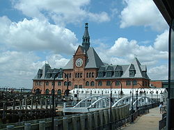
- Central Railroad of New Jersey Terminal
-
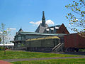
Central Railroad of New Jersey Terminal
 CRRNJ Terminal at Liberty State Park showing ferry slips serving boats to Statue of Liberty National Monument, Ellis Island and Liberty Island

Location: Liberty State Park Coordinates: 40°42′30″N 74°2′39″W / 40.70833°N 74.04417°WCoordinates: 40°42′30″N 74°2′39″W / 40.70833°N 74.04417°W Area: 63 acres (25 ha) Built: 1889 Architect: William H. Peddle, Peabody & Stearns Architectural style: Richardsonian Romanesque Governing body: State NRHP Reference#: 75001138
[1]NJRHP #: 1513[2] Significant dates Added to NRHP: September 12, 1975 Designated NJRHP: August 27, 1975 Central Railroad of New Jersey Terminal, sometimes known as Communipaw Terminal was the Central Railroad of New Jersey's waterfront passenger terminal at the mouth of the Hudson River at the Upper New York Bay in Jersey City, New Jersey.[3]
Contents
Designation


The terminal was built in 1889, replacing an earlier one that had been in use since 1864. It operated until April 30, 1967.[4] The station has been listed on the New Jersey Register of Historic Places[5] and National Register of Historic Places since September 12, 1975.[6] Additionally it is a New Jersey State Historic Site.
Site
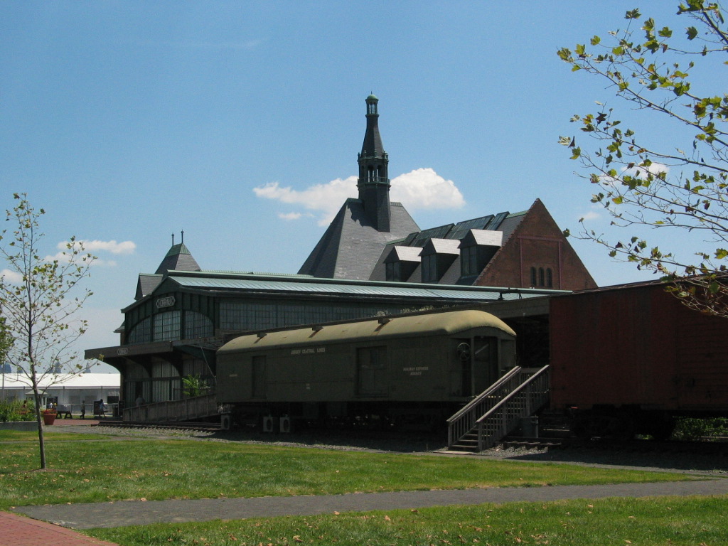
Today, the terminal is part of Liberty State Park, and along with nearby Ellis Island and Statue of Liberty recalls the era of massive immigration through the Port of New York and New Jersey to the United States. It is estimated that around 10.5 million entered the country through the station.[3][7] The area in which the station is located has long been known by as Communipaw, which in the Algonquian language Lenape means big landing place at the side of a river .[8] The first stop just west of the station was indeed called called Communipaw,[9] and was located not far from the village that had been established there in 1634 as part of the New Netherland settlement of Pavonia. The land on which the extensive yards were built were reclaimed, or filled, in a process than was first begun by the Lehigh Valley Railroad. The terminal itself is located adjacent to the Morris Canal Big Basin, which to some degree was made obsolete by the railroads which replaced it. The long cobbled road which ends at the terminal (once called Johnston Avenue for a president of CNJ) called Audrey Zapp Drive, for the environmentalist active in the creation of the park.
Description
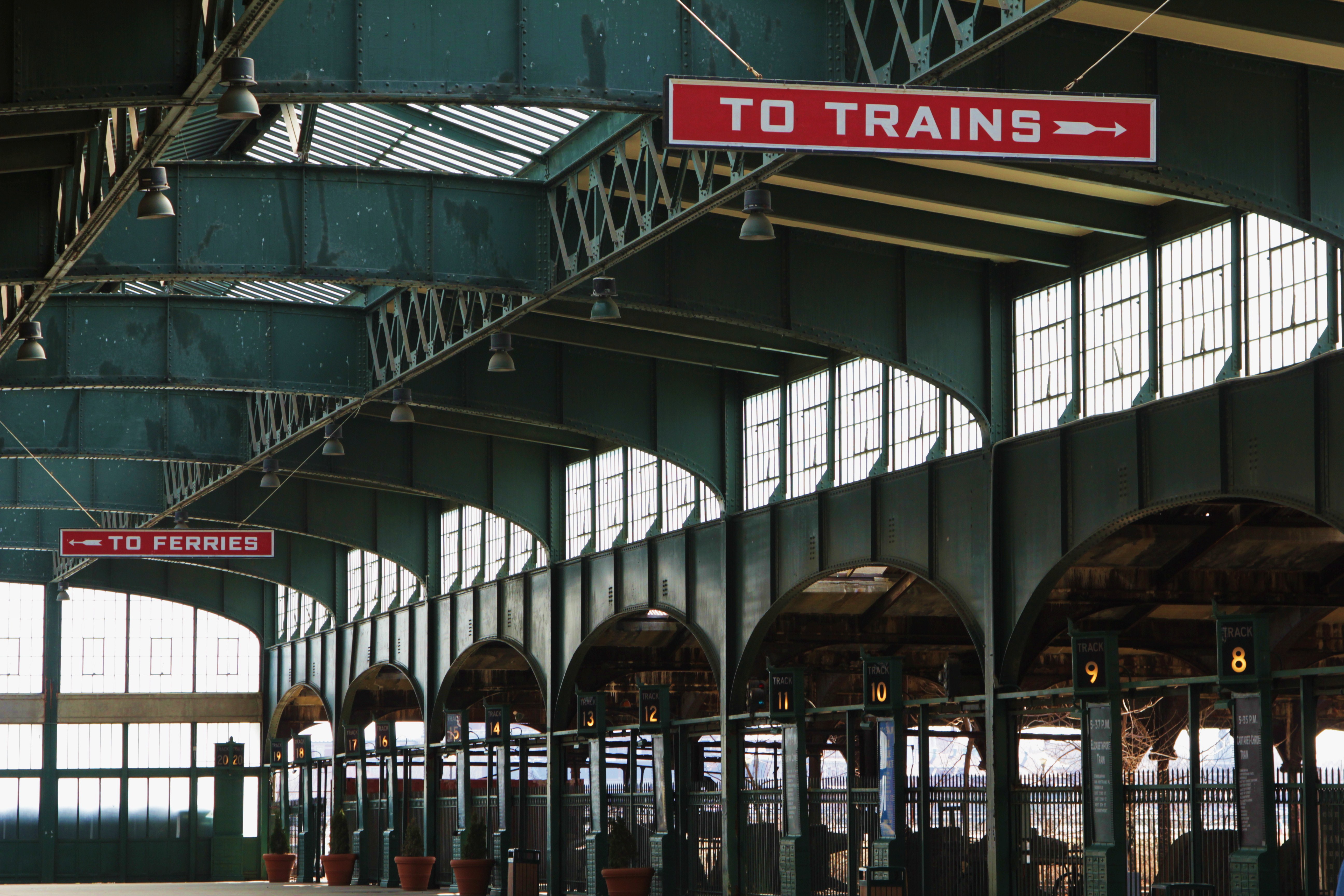
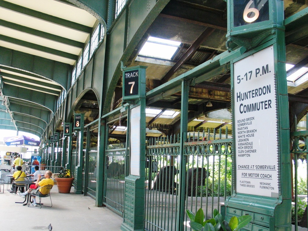
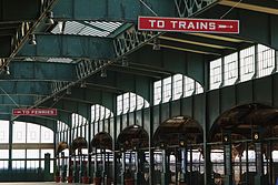 Inside of the Communipaw Terminal
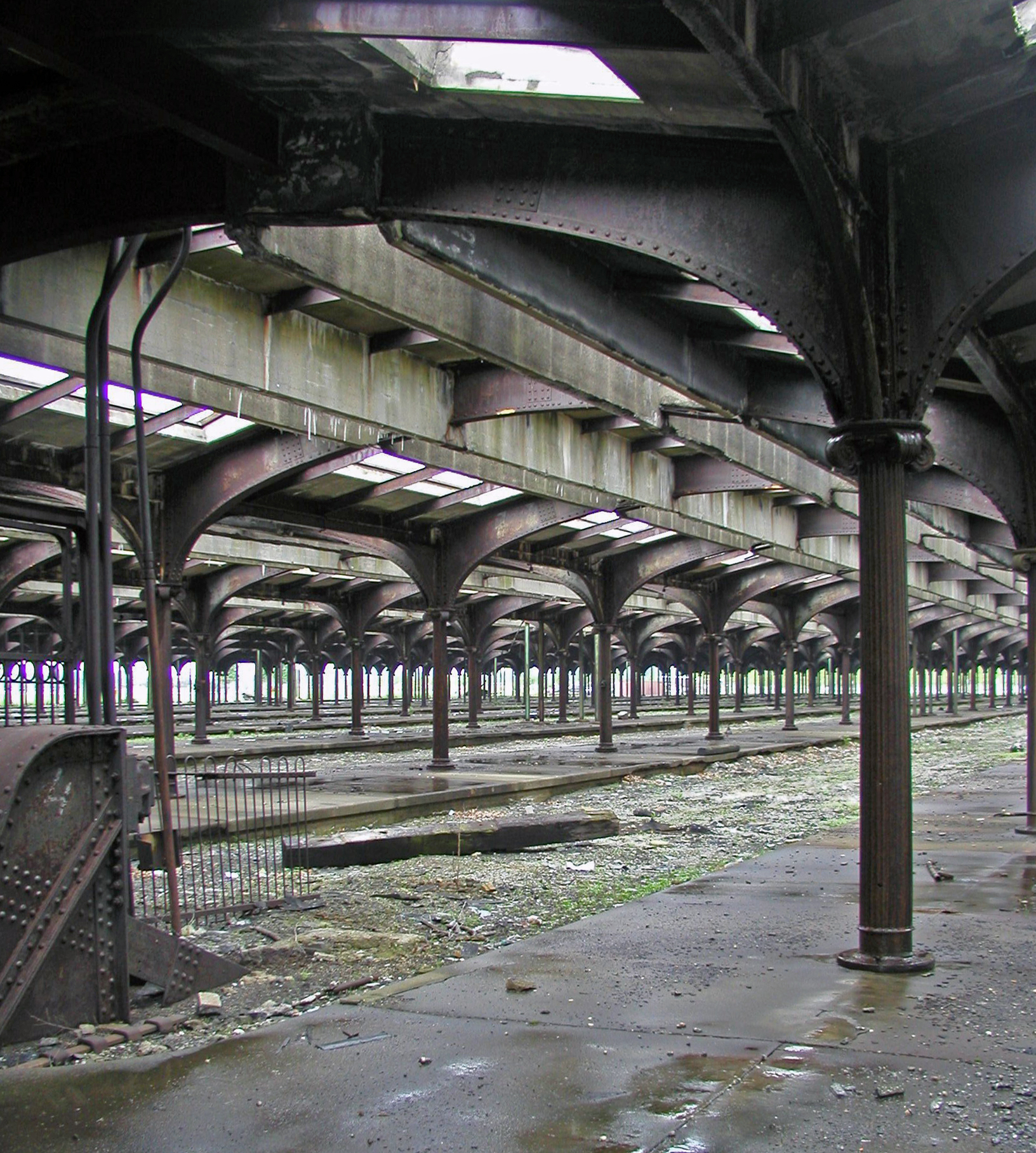
 The concourse at Communipaw Terminal. The abandoned shed, which covered 12 platforms and 20 tracks[10] is closed to the public
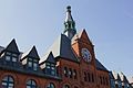
The main building is designed in a Richardsonian Romanesque style. The intermodal facility contains more than a dozen platforms and several ferry slips. Arriving passengers would walk to the railhead concourse and could either pass through its main wating room, by-pass it on either side, and take stairs to the upper level. The ferry slips have also been restored though the structure which housed them has been removed, as have the tracks. The Bush-type trainsheds, the largest ever to be constructed and designed by A. Lincoln Bush, were not part of the original construction, but were built in 1914 and have not been restored.[11]
Service
Trackage
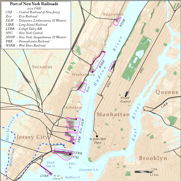
The terminal, along with its docks and yards, was one of several massive complexes that dominated the western waterfront of the New York Harbor from the mid 19th to the mid 20th century. Of the two still standing, the Hoboken Terminal is the only one still in use. Lines from the station headed to the southwest. Arriving at the waterfront from the points required overcoming significant natural obstacles including crossing the Hackensack River and Meadows and Hudson Palisades, and in the case of New Jersey Central, traversing the Newark Bay. For its mainline, the railroad constructed the Newark Bay Bridge to Elizabeth. Its Newark branch cut through Bergen Hill and crossed two bridges at Kearny Point. Both rights-of-way in Hudson County are now used by the Hudson Bergen Light Rail, one terminating at West Side Avenue and the other at 8th Street Station in Bayonne.
Railroad lines
The terminal was also used by the Reading Company and the Baltimore and Ohio Railroad, whose Royal Blue was a premier passenger train to Washington, DC. Jersey Central's Blue Comet provided offered elaborate service to Atlantic City. The railroad's suburban trains, some called clockers, served passengers to the west, and south including the Jersey Shore. (BENNY is term used by residents in the coast for daytrippers from Bayonne, Elizabeth, Newark and New York). When the Aldene Plan was implemented in 1967 the system was dismantled or rerouted. The Aldene Connection connected to the former Lehigh Valley Railroad right-of-way, and trains were re-routed to Newark Penn Station on the Northeast Corridor. Remnants of the network remain.[12] Both the North Jersey Coast Line and the Raritan Valley Line, which still uses the Staute of Liberty as its logo, originally originated at the terminal.
Ferries and Ships
The main ferry from the terminal crossed the river to Pier 39 at Liberty Street and West Street in Manhattan, with additional service to 23rd Street. The B&O's Royal Blue service crossed to Whitehall/South Street. Until the opening of the Verrazano Narrows Bridge there was also service to Brooklyn and Staten Island[13] Other boats, among them the SS Asbury Park and SS Sandy Hook, which travelled to the Raritan Bayshore.[14] In 1941, Railroad Magazine reported that the CRRNJ ferryboat fleet made 374 one-way crossings of the North River (Hudson River) each day. (Nov., p. 41)
Current uses
Following the Aldene Plan the terminal sat unused but maintained and guarded by the Central Railroad of New Jersey. During this time a portion of the movie, Funny Girl was filmed at the terminal.[15] Following the closure of CNJ shops and engine facilities nearby in the early 1970s, the terminal sat abandoned. The terminal is one of the main attractions at Liberty State Park, housing a museum with permanent and rotating exhibitions. Ferries to the Statue of Liberty National Monument, Ellis Island and Liberty Island depart daily.[16][17] Numerous fairs, concerts, and other sponsored events (among them the Central Jersey Heritage Festival [18] and the All Points West Music & Arts Festival) take place at the station and its grounds, which is a very popular place from which to view 4 July fireworks. On September 11, 2001 its parking lot was the staging area for dozens of ambulances that were mobilized to transport victims of the attack. There are proposals to built a trolley line to the terminal building and other points in the park from the Liberty State Park Station[19] of the Hudson Bergen Light Rail, which is also served by NJT Bus 6[20]
Gallery
-
The upper facade of the terminal
-
The grounds on the north side of the terminal
-
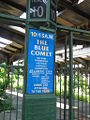
A reproduction of a tablet designator for the CNJ Blue Comet
-
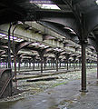
Bush shed at CRRNJ Terminal, the largest ever built[21]
-
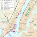
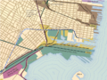
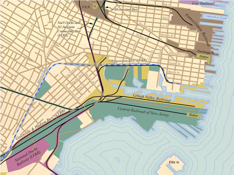
CRRNJ and other railroad terminals ca. 1900
-
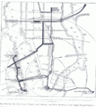
Map showing the terminal facility in 1910
-
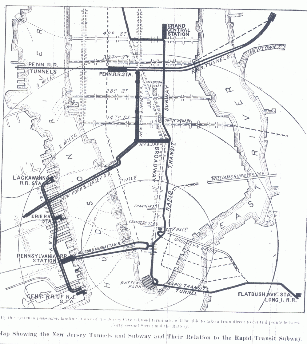
Plans to extend the Hudson Tubes never materialized
-
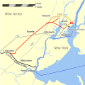
Map of lines approaching Hudson Waterfront from south. The grey CNJ line from Bayonne to Elizabeth was carried by the CNJ's Newark Bay Bridge
See also
- National Register of Historic Places listings in Hudson County, New Jersey
- Timeline of Jersey City area railroads
- List of ferries across the Hudson River in New York City
- List of stations on the Central Railroad of New Jersey
- National Limited
- Central Railroad of New Jersey Freight Station
- Newark Bay, New Jersey rail accident
- Newark and New York Railroad Bridge
References
- ^ "National Register Information System". National Register of Historic Places. National Park Service. 2009-03-13. http://nrhp.focus.nps.gov/natreg/docs/All_Data.html.
- ^ "New Jersey and National Registers of Historic Places – Hudson County". NJ DEP – Historic Preservation Office. June 2, 2011. p. 7. http://www.state.nj.us/dep/hpo/1identify/lists/hudson.pdf. Retrieved 2011-06-20.
- ^ a b Jersey City Past and Present
- ^ http://www.hmdb.org/marker.asp?marker=13290
- ^ New Jersey and National Registers of Historic Places
- ^ National Register of Historic Places in Hudon County
- ^ NJ DEP LSP:Communipaw Terminal
- ^ Indian Place names in New Jersey
- ^ List of stations on the Central Railroad of New Jersey. (2009, August 14). In Wikipedia, The Free Encyclopedia. Retrieved 12:31, November 21, 2009, from http://en.wikipedia.org/w/index.php?title=List_of_stations_on_the_Central_Railroad_of_New_Jersey&oldid=307851840
- ^ Karnoutsos, Carmela (September 16, 2009). "Jersey City Past and Present". New Jersey City University. http://www.njcu.edu/programs/jchistory/Pages/C_Pages/Central_Railroad_of_New_Jersey.html. Retrieved November 21, 2009.
- ^ French, Kenneth (February 24, 2002). Images of America:Railroads of Hoboken and Jersey City. Portsmouth, New Hampshire: Arcadia Publishing. pp. 25–29. ISBN 978-0-7385-0966-2. http://www.arcadiapublishing.com/mm5/merchant.mvc?Screen=PROD&Product_Code=9780738509662&Store_Code=arcadia&search=Images+of+Rail&offset=0&filter_cat=&PowerSearch_Begin_Only=&sort=&range_low=&range_high=%20%26srch_series%3D1. Retrieved November 21, 2009.
- ^ Central Lines today
- ^ French, Kenneth (2002). Images of America:Railroads of Hoboken and Jersey City. USA: Arcadia Publishing. pp. 30. ISBN 978-0-7385-0966-2. http://www.arcadiapublsihing.com.
- ^ French, Kenneth (2002). Images of America:Railroads of Hoboken and Jersey City. USA: Arcadia Publishing. pp. 25–29. ISBN 978-0-7385-0966-2. http://www.arcadiapublsihing.com.
- ^ IMDB.com "Funny Girl (1968)" filming locations
- ^ Ferry map
- ^ The Historic CRRNJ Train Terminal
- ^ Website memorial to the past Jersey Central Heritage Festivals
- ^ Kaulessar, Ricardo (September 6, 2009). "Trolley through Liberty State Park?". Hudson Reporter (Hoboken). http://hudsonreporter.com/pages/full_story/push?article-Trolley+through+Liberty+State+Park-+-Rail+fans+hope+to+bring+back+area%E2%80%99s+railroad+past-%20&id=3531094-Trolley+through+Liberty+State+Park-+-Rail+fans+hope+to+bring+back+area%E2%80%99s+railroad+past-&instance=lead_story_left_column. Retrieved May 30, 2010.
- ^ NJT bus 6 schedule
- ^ http://www.state.nj.us/dep/parksandforests/parks/liberty_state_park/liberty_crrnj.html
External links
- Liberty Historic Railway
- Ellis/Liberty Island Ferry map
- Wikipmapia: Communipaw Terminal
- Locomotives at NRRNJ Terminal
- Timeline of Communipaw Cove
- CRRNJ Bronx Terminal
- CRRNJ Bronx Terminal
Major railroad stations of New York City and vicinity Active terminals Major transfer stations Historical terminals New Jersey Historic Sites Allaire Village • Barnegat Light • Batsto Village • Boxwood Hall • Cape May Light • Central Railroad of New Jersey Terminal • Clarke House • Craig House • Delaware and Raritan Canal State Park • Blackwells Mills Canal House • Mule Tenders Barracks • Port Mercer Canal House • Prallsville Mills • Double Trouble Village • Fort Mott • Grover Cleveland Birthplace • Hancock House • The Hermitage • Hillman Hospital House • High Point Monument • Indian King Tavern • Johnson Ferry House • Long Pond Ironworks Historic District • Monmouth Battlefield • Old Dutch Parsonage • Princeton Battlefield • Ringwood Manor • Rockingham • Skylands Manor & State Botanical Garden • Somers Mansion • Steuben House • Trenton Battle Monument • Navesink Twin Lights • Wallace House • Walt Whitman House • Washington Crossing • Waterloo Village • Whitesbog Village
National Register of Historic Places in Hudson County, New Jersey Historic districts Clark Thread Company Historic District | Hamilton Park Historic District | Harsimus Cove Historic District | Lembeck and Betz Eagle Brewing Company District | Paulus Hook Historic District | Van Vorst Park Historic District

Other properties Association of Exempt Firemen Building | Dr. William Barrow Mansion | Bayonne Truck House No. 1 | Bayonne Trust Company | Buildings at 1200-1206 Washington Street | Church of Our Lady of Grace | Church of the Holy Innocents | Dock Bridge | Engine Company No. 2 | Engine Company No. 3 | Engine Company No. 4 | Engine Company No. 5 | Engine Company No. 6 | Engine House No. 3, Truck No. 2 | Erie-Lackawanna Railroad Terminal at Hoboken | Fairmount Apartments | Ficken's Warehouse | Firemen's Monument | First Baptist Church | First Reformed Dutch Church of Bergen Neck | Grace Church Van Vorst | Great Atlantic and Pacific Tea Company Warehouse | Hackensack Water Company Complex | Hale-Whitney Mansion | Highland Hose No. 4 | Hoboken City Hall | Hoboken Land and Improvement Company Building | Holland Tunnel | Hudson and Manhattan Railroad Powerhouse | Hudson County Courthouse | Jefferson Trust Company | Jersey City Central Railroad Terminal | Jersey City High School | Jersey City Medical Center | Jersey City YMCA | Kestrel (steam yacht) | Keuffel and Esser Manufacturing Complex | Labor Bank Building | Monastery and Church of Saint Michael the Archangel | Morris Canal | Old Bergen Church | Pohlmann's Hall | Pulaski Skyway | Robbins Reef Light Station | St. Anthony of Padua Roman Catholic Church | St. Patrick's Parish and Buildings | Statue of Liberty National Monument, Ellis Island and Liberty Island | Edwin A. Stevens Hall | United Synagogue of Hoboken | Van Wagenen House
Categories:- Railway stations opened in 1864
- Railway stations closed in 1967
- Buildings and structures completed in 1889
- Buildings and structures in Jersey City, New Jersey
- Stations along Central Railroad of New Jersey lines
- Ferry terminals in New Jersey
- Former railway stations in the United States
- Hudson River
- Museums in Hudson County, New Jersey
- National Register of Historic Places in New Jersey
- Railroad museums in New Jersey
- Railroad terminals in New York City
- Railway stations in New Jersey
- Romanesque Revival architecture in New Jersey
- Richardsonian Romanesque architecture
- Stations along Baltimore and Ohio Railroad lines
- Stations along Reading Company lines
- Transit hubs serving New Jersey
- Transportation in Hudson County, New Jersey
-


Wikimedia Foundation. 2010.