Cockatoo Island ferry wharf

Cockatoo Island ferry wharf
Sydneyferriessign.png
Cockatoo Island
CockatooIslandWharf.png
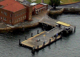
Rydalmere Ferry
Suburb Cockatoo Island
Street(s) N/A
Travel time from Circular Quay 18 mins
Number of berths 1
Ticket barriers No
Transfers available No
Disabled access Wheelchair symbol.svg No
Travel distance from Circular Quay

Cockatoo Island Ferry Wharf is the wharf serving the locality of Cockatoo Island in Sydney Australia, now largely an historical attraction. It is located on the Rydalmere ferry route travelling between Rydalmere and Circular Quay ferry wharves. There is approximately one service per hour, although ferries heading to Rydalmere only stop in the mornings, and ferries to Circular Quay only stop in the afternoons.[1] The wharf has a single jetty used for the docking of ferries. Previously used for the transport of workers on the island, the wharf opened for passengers in April 2007 as a three-month trial.[2] The service is now part of the Rydalmere timetable. As of April 2008, no ferry signage has been installed at the wharf, and not all services are listed on the timetable.[3]

Jetties and services

Wharf 1

  • Rydalmere Ferry - services to Meadowbank, Sydney Olympic Park and Rydalmere; services to Circular Quay

Parramatta Ferries, Bayview Park Ferries, and Balmain/Birkenhead Ferries bypass this wharf but do not stop.

Neighbouring wharves

Preceding wharf
(towards City)
Sydney Ferries
Routes
Following wharf
(away from City)
King St No 3   Rydalmere Ferry   Drummoyne

References

  1. ^ Brownbill, Chris, "Australian Bus & Train Journey Planner: Route Details: Rydalmere Ferry". Accessed 31 March 2008.
  2. ^ Sydney Ferries, "Sydney Ferries 2007 Annual Report". Accessed 26 April 2008.
  3. ^ Dugald Jellie, "Camp under the cranes", Sydney Morning Herald (Travel), 26 April 2008. Accessed 26 April 2008.

Coordinates: 33°50′44.14″S 151°10′23.60″E / 33.8455944°S 151.173222°E / -33.8455944; 151.173222


Wikimedia Foundation. 2010.

Игры ⚽ Нужен реферат?

Look at other dictionaries:

  • Cockatoo Island ferry wharf, Sydney — Cockatoo Island Ferry Wharf is the wharf serving the locality of Cockatoo Island in Sydney Australia, now largely an historical attraction. It is located on the Rydalmere ferry route travelling between Rydalmere and Circular Quay ferry wharves.… …   Wikipedia

  • Cockatoo Island (New South Wales) — Cockatoo Island Sydney, New South Wales Cockatoo Island Population …   Wikipedia

  • Drummoyne ferry wharf — Drummoyne Rydalmere Ferry …   Wikipedia

  • Darling Harbour, New South Wales — Darling Harbour looking towards the east Darling Harbour is a locality of the city centre of Sydney, Australia. It is a large recreational and pedestrian precinct that is situated on western outskirts of the Sydney central business district. The… …   Wikipedia

  • Manly Beach — is a beach situated in Sydney s Northern Beaches, Australia. From north to south, the three main sections are Queenscliff, North Steyne, and South Steyne …   Wikipedia

  • Circular Quay — This article is about the locality. For the racehorse of the same name, see Circular Quay (horse). Circular Quay Circular Quay is a location in Sydney, New South Wales, Australia. It is located on the northern edge of the Sydney central business… …   Wikipedia

  • Sydney Olympic Park, New South Wales — Sydney Olympic Park Sydney, New South Wales ANZ Stadium Established …   Wikipedia

  • Dawes Point, New South Wales — Dawes Point Sydney, New South Wales Sydney Harbour Bridge, viewed from Observatory Hill Population …   Wikipedia

  • Dee Why, New South Wales — For the ferry, see Dee Why ferry. Dee Why Sydney, New South Wales Dee Why Beach …   Wikipedia

  • Drummoyne, New South Wales — Drummoyne Sydney, New South Wales Apartments on the Parramatta River, Drummoyne …   Wikipedia

Share the article and excerpts

Direct link
Do a right-click on the link above
and select “Copy Link”