- Pill, Somerset
-
Not to be confused with Pylle, Somerset.
Coordinates: 51°28′43″N 2°41′09″W / 51.4787°N 2.6859°W
Pill 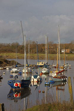
Pill Creek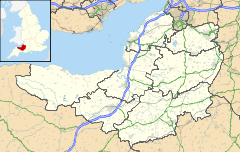
 Pill
Pill
Pill shown within SomersetOS grid reference ST524757 Unitary authority North Somerset Ceremonial county Somerset Region South West Country England Sovereign state United Kingdom Post town BRISTOL Postcode district BS20 Dialling code 01275 Police Avon and Somerset Fire Avon Ambulance Great Western EU Parliament South West England UK Parliament North Somerset List of places: UK • England • Somerset Pill is a village in North Somerset. It is situated on the southern bank of the Avon. Pill now includes Ham Green and is adjacent to the village of Easton-in-Gordano. Opposite Pill is the Bristol suburb of Shirehampton.
"Pill", in Anglo-Saxon, means a "creek" or "inlet" off a river or channel or a small harbour, often tidal and occasionally used as a dock.
Contents
History
The original name Crockerne Pill means literally 'pottery wharf' and arose from the fact that an industrial-scale pottery thrived nearby. The actual kiln was excavated about 50 years ago and is located in the fields above Chapel Pill. The pottery was made in the period from 1100 AD to 1250 AD and was exported from Pill by boat. The so-called 'Ham Green' pottery has been found and identified in archaeological digs from the Algarve in Portugal to Iceland. It is an important archaeological 'dating tool' because the period of manufacture is so precise. Bristol City Museum has a good selection of pottery artefacts from the site and other locations showing the unique decoration and form of Ham Green pottery.
The town was traditionally the residence of pilots,[1] who would guide boats up the Avon Gorge, between the Bristol Channel and the Port of Bristol. The port moved in the 20th century to Avonmouth and the Royal Portbury Dock. Pill was once home to 21 public houses and was known as being a rough place, to the extent that the founder of the Methodist Church, John Wesley, says in an entry in his journals for 3 October 1755:
I rode over to Pill, a place famous from generation to generation, even as Kingswood itself, for stupid, brutal, abandoned wickedness.
 The Portishead Railway viaduct in Pill.
The 1860s saw the building of the railway line between Bristol (Temple Meads) and Portishead. Opened to passengers in 1863, passing right through the village of Pill. A large number of properties had to be demolished to allow its necessary straight and level passage. It brought new life to the area, not to mention new blood as many of the navvies working the line met and married local girls and stayed on after the line was complete to raise their families. They brought new names, some of which are still with us today, over 100 years on. The railway consumed not only dwellings and other buildings but many acres of farm land during its construction.
The small rowed ferry from Pill to Shirehampton closed because of loss of trade once the Avonmouth Bridge opened in 1974 enabling pedestrians to walk over the Avon. Few did of course, but some rode their bicycles and many more turned to their cars. So a transport link to and from the parish of Easton-in-Gordano, one that had survived since Medieval times, was closed and the river mud has swallowed up most of the now unattended slipways.
In 1971 the Royal National Lifeboat Institution stationed an inshore lifeboat at Pill. It was withdrawn in 1974.[2]
Amenities
The parish has five churches: St George's, Easton-in-Gordano; Christ Church, Pill; The Salvation Army, Pill Baptist Church and Pill Methodist Church.
Pill has several shops in the centre for day-to-day needs, including a NISA, pharmacy, Post Office and hair salon. There is a shop for local charity, CHEER, and a small flower–hardware shop, 'Practically Everything'. There is a co-op at the top of the village near where the railway station used to be. Pill is home to several take-away restaurants. It can no longer boast 21 pubs and currently has five: The Kings Head, The Anchor, The Star, The Duke and the Pill Memorial Club, although this excludes the nearby pubs in Easton in Gordano.
The village and its vanished ferry are commemorated in the Adge Cutler and The Wurzels song "Pill Pill".
It is commonly used as a place for commuting to Bristol as it has excellent transport links, being close to the M5 and Bristol.
Pill marks the start of the National Cycle Network 33 (the Wessex Cycleway) which also takes in Clevedon, Weston-super-Mare, Bridgwater, Chard and Seaton.
Schools
- St Katherine's school, located at Ham Green within Abbots Leigh parish, not actually in Pill, with approximately 1,000 students aged 11–18.
- Crockerne Primary School, which is located in the village and caters for Nursery to Year 6 pupils. The school has one of North Somerset's first children's centres, officially opened on 1 July 2006, as well as a small, indoor, heated swimming pool and an active PTA.
See also
References
- ^ "Pill: The village of pilots". Easton in Gordano. http://www.easton-in-gordano.org.uk/Pages/Pilots.html. Retrieved 2009-08-18.
- ^ Denton, Tony (2009). Handbook 2009. Shrewsbury: Lifeboat Enthusiasts Society. p. 60.
External links
Categories:- Villages in North Somerset
- Ports and harbours of Somerset


Wikimedia Foundation. 2010.