- Church of St James, Ashwick
-
Church of St James 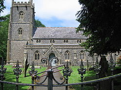
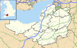
 Location within Somerset
General information Town or city Ashwick Country England Coordinates 51°14′02″N 2°31′16″W / 51.2339°N 2.5212°W Completed 1881 The Church of St James in Ashwick, Somerset, England has a tower dating from around 1450 and the rest of the church from 1881. It is a Grade I listed building,[1] adjacent to Ashwick Court.
The Victorian gothic building was erected between 1876 and 1881 by Browne and Gill of Bath.[2] However, the church tower dates back to 1463.
The earliest record of a church on the site is 1413, when Bishop Bubwith dedicated a churchyard at Ashwick and authorised burials to take place there, but it is not known when the church was first built. The church was originally a chapel of ease connected to the vicarage at Kilmersdon, near Radstock.[3] It remained so until the formation of Ashwick parish. The benefice of Oakhill was added in 1923 and Binegar was added in 1969, since when one rector has overseen all three villages.
At the west end of the aisles in the Church of St James two memorial tablets can be seen. These are dedicated to John Billingsley, his wife Mary, and their family.[4] The writer of the 1794 Survey of Somerset, Billingsley was a leading agriculturalist who was one of the founders of the Bath and West Society, known today as the Royal Bath and West of England Society.
References
- ^ "Church of St James". Images of England. http://www.imagesofengland.org.uk/details/default.aspx?id=266400. Retrieved 2006-12-11.
- ^ Atthill, Robin (1976). Mendip: A new study. Newton Abbot, Devon: David & Charles. ISBN 0715372971.
- ^ "Ashwick Design Statement". Mendip Council. http://www.mendip.gov.uk/Documents/Regeneration/Heritage%20Conservation/VDS/Ashwick.pdf. Retrieved 2009-04-10.
- ^ "Nicholas Billingsley tomb and railed enclosure in churchyard". Images of England. http://www.imagesofengland.org.uk/details/default.aspx?id=266401. Retrieved 2006-12-11.
Categories:- Religious buildings completed in 1881
- 19th-century Church of England church buildings
- Grade I listed churches
- Grade I listed buildings in Somerset
- Church of England churches in Mendip


Wikimedia Foundation. 2010.