- Church of Panagia Chalkeon
-
Paleochristian and Byzantine Monuments of Thessalonika * UNESCO World Heritage Site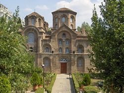
The Church of Panagia ChalkeonCountry Greece Type Cultural Criteria i, ii, iv Reference 456 Region ** Europe and North America Coordinates 40°38′N 22°56′E / 40.633°N 22.933°E Inscription history Inscription 1988 (12th Session) * Name as inscribed on World Heritage List
** Region as classified by UNESCOThe Church of Panagia Chalkeon (Greek: Παναγία τῶν Χαλκέων) is an 11th-century Byzantine church in the northern Greek city of Thessaloniki.
Contents
Location
The church is located at Dikastirion Square, north of the Via Egnatia at the point where it crosses the Aristotelous Avenue, which leads to the Aristotelous Square. The archaeological site of the city's Roman forum is located northeast, while its name, which translates as "the Virgin of the Copper-smiths", derives from its proximity to the area traditionally occupied by the city's coppersmiths.[1]
History and description
According to the founder's inscription above the west entrance, the church was built in 1028 by the protospatharios Christopher, katepano of Longobardia, and his wife Maria, son Nikephoros and two daughters, Anna and Katakale. Christopher's tomb was probably located in an arcosolium on the church's northern wall.[1][2]
The ground plan is that of a classic "cross-in-square-form" typical of Macedonian-period architecture, with four columns and three domes, one central and two over the narthex. The entire building is built of bricks, which gave it the popular nickname "Red Church" (Κόκκινη Εκκλησιά). The exterior is enlivened with a variety of arches and pilasters, elements which can be traced to Constantinopolitan influence. The use of arches with several setbacks gives the building a "sculpted" appearance. In the interior, most of the carved marble decoration, as well as frescoes from the 11th and 14th centuries have been preserved.[1][2]
With the conquest of the city in 1430 by the Ottoman Turks, the church was turned into a mosque, named Kazancilar Camii ("Mosque of the Cauldron-Merchants").[1]
References
- ^ a b c d "Παναγία των Χαλκέων, Θεσσαλονίκη" (in Greek), Hellenic Ministry of Culture, http://odysseus.culture.gr, retrieved 2010-04-21
- ^ a b Kazhdan, Alexander, ed. (1991), Oxford Dictionary of Byzantium, Oxford University Press, p. 1569, ISBN 978-0-19-504652-6
External links
 Media related to Church of Panagia Chalkeon, Thessaloniki at Wikimedia Commons
World Heritage Sites in Greece North Aigai · Mount Athos · Paleochristian and Byzantine Monuments of Thessalonica: (Hagios Demetrios, Arch and Tomb of Galerius, Hagia Sophia, Church of Panagia Chalkeon, Church of Saint Nicholas Orphanos, Church of the Holy Apostles, Church of the Acheiropoietos, Monastery of Latomos, Church of Saint Panteleimon)

Central Delphi · Epidaurus · Hosios Loukas · Meteora · Mycenae and Tiryns · Mystras · Old Town of Corfu · Olympia · Temple of Apollo Epicurius at Bassae
Attica Aegean Islands
and CreteCoordinates: 40°38′12.51″N 22°56′37.45″E / 40.6368083°N 22.9437361°E
Categories:- Buildings and structures in Thessaloniki
- Tourism in Greece
- Byzantine churches of Thessalonica
- World Heritage Sites in Greece
- 1028 establishments
- 1020s architecture
- 11th-century church buildings
- Mosques converted from churches by the Ottoman Empire
- Former mosques

Wikimedia Foundation. 2010.