- Jomolhari
-
Jomolhari 
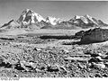
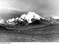
Jomolhari seen from the southwest
Picture taken in Phari, Tibet, in 1938Elevation 7,326 m (24,035 ft) [1] Prominence 2,077 m (6,814 ft) Listing Ultra Translation Mountain of the Goddess (Tibetan) Location Location on the border between Tibet and Bhutan
 Jomolhari
Location Bhutan, Tibet Range Himalaya Coordinates 27°49′27″N 89°16′12″E / 27.82417°N 89.27°ECoordinates: 27°49′27″N 89°16′12″E / 27.82417°N 89.27°E Climbing First ascent May 1937 Jomolhari or Chomolhari[2] (Tibetan: ཇོ་མོ་ལྷ་རི, Wylie: jo mo lha ri, ZYPY: Qomo Lhari; simplified Chinese: 绰莫拉日峰; traditional Chinese: 綽莫拉日峰; pinyin: Chuòmòlārì Fēng) sometimes known as "the bride of Kangchenjunga”, is a mountain in the Himalayas, straddling the border between Yadong County of Tibet and the Paro district of Bhutan. The north face rises over 2,700 metres (8,900 ft) above the barren plains. The mountain is the source of the Paro Chu (Paro river) which flows from the south side and the Amo Chu which flows from the north side.
Contents
Religious Significance
The mountain is sacred to Tibetan Buddhists who believe it is the abode of one of the Five Tsheringma Sisters;[3] (jo mo tshe ring mched lnga) — female protector goddesses (Jomo) of Tibet and Bhutan, who were bound under oath by Guru Padmasambhava to protect the land, the Buddhist faith and the local people.
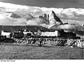
On the Bhutanese side is a Jomolhari Temple, toward the south side of the mountain about a half-day's journey from the army outpost between Thangthangkha and Jangothang at an altitude of 4150 meters. Religious practitioners and pilgrims visiting Mt. Jomolhari stay at this temple. There are several other sacred sites near Jomolhari Temple, including meditation caves of Milarepa and Gyalwa Lorepa. Within an hour's walk up from the temple at an altitude of c. 4450 meters is Tseringma Lhatso, the "spirit lake" of Tsheringma.[4]
In Tibet there is an annual pilgrimage from Phari Dzong to a holy lake, Jomo Lharang, which lies at c. 5100 m elevation, just north of the mountain.
Climbing history
Despite its notability and spectacular visibility from the old trade route between India and Tibet's Pagri Valley, the mountain has seen little climbing activity, probably because of access restrictions on the Bhutanese side and the difficulty of the routes from the Tibetan side. The first ascent was made on May 17th 1937 by a five-man British expedition, with Freddie Spencer Chapman and Sherpa Pasang Dawa Lama (of the American K2 expedition fame) reaching the summit from Bhutan over the southeast spur. The protracted and epic descent, which they were fortunate to survive, is described in detail in F. Spencer Chapman’s Helvellyn to Himalaya (1940) Chatto & Windus, London.
The second ascent was in 1970 on 24 April over the same route by a joint Bhutanese-Indian military expedition led by Colonel Narendra Kumar. This ascent was notable also for the disappearance of two climbing members and a sherpa in the second summit party the following day. Dorjee Lhatoo (Nanda Devi East 1975, West 1981) led the route, partnered with Prem Chand (2nd ascent Kanchenjunga 1977) all the way to the summit via two camps. Lhatoo was charged with laying a "yangu" offering on the summit by the Bhutanese King in order to "appease" mountain deities - apparently a pot containing gold, silver and precious stones. The following day, the second party of three were spotted close to the ridge when they became obscured by cloud. When the cloud lifted, they were gone. A telephoto lens and fruit cans were found on the ridge by a search party. Prem Chand went up to the ridge and reported gunshots thudding into the ice and whipping up ice chips - thus ending any further attempts in locating the missing bodies. Lhatoo and Prem Chand, on their way up during their successful summit attempt had reported seeing a lot of PLA activity on the Lhasa-Chumbi highway. The reason for their disappearance remains speculative - did they fall or were they shot? All three were relatively inexperienced climbers and Lhatoo later speculated on the exposure on the knife-edged ridge leading to the summit slope as a possible incident site. He (an ex-Gurkha himself) is quoted as believing the shooting theory to be unlikely but possible, citing his difficulty in estimating the distance between the ridge and possible Chinese positions on the Tibetan side. An account of the expedition is available in the Himalayan Journal 2000.[5] Prem Chand has not spoken publicly on the matter. Chinese displeasure with Bhutan over the expedition and sensitivities in New Delhi led to a complete media blackout of what was otherwise a notable Indian climb.
The third ascent was made in 1996 by a joint Japanese-Chinese expedition which reached the south col from the Tibetan side and climbed the peak over the south ridge. On 7 May 2004, British climbers Julie-Ann Clyma and Roger Payne reached the summit via the c. 5800 m south col as well, in a single day's dash from the col, after attempts to climb the impressive northwest pillar were thwarted by strong winds.[6]
In October 2006, a six-member Slovenian team climbed two new routes, registering the fifth and sixth ascents. Rok Blagus, Tine Cuder, Samo Krmelj and Matej Kladnik took the left couloir of the north face to the East ridge at c. 7100 m, from which they followed the ridge to the top, while Marko Prezelj and Boris Lorencic climbed the northwest ridge in a six-day round trip.[7] This climb earned Prezelj and Lorencic the Piolet d'Or in January 2007.[8]
Sources
- Dorjee Lhatoo (2000). "Expeditions and Notes - Ascent of Chomolhari". The Himalayan Journal 56: 149–154.
- Thinley, Lopon Kunzang; KMT Research Group (2008). Seeds of Faith: A Comprehensive Guide to the Sacred Places of Bhutan. Volume 1. Thimphu: KMT Publications. ISBN 9993622419.
References
- ^ Official Chinese PLA mapping
- ^ Also spelled Jomolari or Jumolhari
- ^ Lopon Kunzang Thinley, 2008. p. 200
- ^ Lopon Kunzang Thinley, 2008. pp. 200-202
- ^ The Himalayan Journal, Vol. 56, 2000. Expeditions and Notes - Ascent of Chomolhari by Dorjee Lhatoo pp. 149-154. -An account of the second ascent of the mountain from Bhutan in 1970, by a joint Bhutanese-Indian expedition
- ^ "Chomolhari climbing report". Roger Payne. 2004. http://www.rogerpayne.info/Chomolhari%20Report%202004.pdf.
- ^ "Chomolhari 2006". Climb and More. http://www.climbandmore.com/climbing,283,0,1,news.html.
- ^ "Piolet d'Or - 2006: Ascents, comments of the climbers". Mountain.RU. http://www.mountain.ru/article/article_display1.php?article_id=1655.
Gallery
-
-
-
-
-

Mt. Jomolhari at dawn from Thangthangkha camp
-

Mt. Jomolhari at dawn from Jangothang
-

Mt. Jomolhari from Jangothang, Bhutan
-

Mt Jomolhari viewed from near Neleyla pass
External links
- Chomolhari from Tibet
- pre 1950 photos of Chomolhari
- Photos of Jumolhari Mountain from Bhutan
- Chomolhari The peak of a white celestial maiden (You Tube)[1][2][3][4]
Categories:- Mountains of Bhutan
- Mountains of Tibet
- Sacred mountains
- Bhutan–China border
- International mountains of Asia


Wikimedia Foundation. 2010.