- Perryville Municipal Airport
-
Perryville Municipal Airport 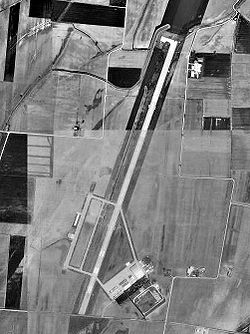
1996 USGS photo IATA: none – ICAO: none – FAA LID: K02 Summary Airport type Public Owner City of Perryville Serves Perryville, Missouri Location Perry County, Missouri, near Chester, Illinois Elevation AMSL 372 ft / 113 m Coordinates 37°52′07″N 089°51′44″W / 37.86861°N 89.86222°W Runways Direction Length Surface ft m 2/20 7,003 2,135 Concrete Statistics (2008) Aircraft operations 5,900 Based aircraft 9 Source: Federal Aviation Administration[1] Perryville Municipal Airport (FAA LID: K02) (also known as McBride Airport) is a city-owned public-use airport located nine nautical miles (17 km) north of the central business district of Perryville, a city in Perry County, Missouri, United States.[1]
Contents
Facilities and aircraft
Perryville Municipal Airport covers an area of 351 acres (142 ha) at an elevation of 372 feet (113 m) above mean sea level. It has one runway designated 2/20 with a concrete surface measuring 7,003 by 100 feet (2,135 x 30 m).[1]
For the 12-month period ending August 13, 2008, the airport had 5,900 aircraft operations, an average of 16 per day: 86% general aviation, 8% military and 5% air taxi. At that time there were nine aircraft based at this airport: eight single-engine and one helicopter.[1]
History
The airport was built in 1942 by the United States Army Air Forces as a primary (stage 1) pilot training airfield assigned to AAF Flying Training Command, Southeast Training Center (later Eastern Flying Training Command). It was named Chester Army Airfield and consisted of two parallel 2000' runways aligned NNE/SSW (02/20).
Flight training was provided by Anderson Air Activities to the aviation cadets assigned to the airfield and Fairchild PT-19s were the primary trainer used. Pilot training at the airfield apparently ended on 30 May 1944, with the drawdown of AAFTC's pilot training program. The airfield was turned over to civil control at the end of the war though the War Assets Administration (WAA).
See also
References
 This article incorporates public domain material from websites or documents of the Air Force Historical Research Agency.
- Shaw, Frederick J. (2004), Locating Air Force Base Sites History’s Legacy, Air Force History and Museums Program, United States Air Force, Washington DC, 2004.
- Manning, Thomas A. (2005), History of Air Education and Training Command, 1942–2002. Office of History and Research, Headquarters, AETC, Randolph AFB, Texas ASIN: B000NYX3PC
External links
- City of Perryville, Airport Division
- Aerial photo from USGS The National Map via MSR Maps, 10 April 1996
- FAA Terminal Procedures for K02, effective 20 October 2011
- Resources for this airport:
- AirNav airport information for K02
- FlightAware airport information and live flight tracker
- SkyVector aeronautical chart for K02
 Army Air Forces Training Command
Flying Training Flying Schools Eastern Flying Training Command · Central Flying Training Command · Western Flying Training CommandSpecialized Schools Bombardier · Contract Flying · Glider Training · Gunnery · Navigator
Technical Training Eastern Technical Training Command · Central Technical Training Command · Western Technical Training CommandCategories:- 1942 establishments
- Airports in Missouri
- Buildings and structures in Perry County, Missouri
- Airfields of the United States Army Air Forces in Missouri
- USAAF Contract Flying School Airfields

Wikimedia Foundation. 2010.