No. 620 Squadron RAF — No 620 Squadron RAF Official Squadron badge of No 620 Squadron RAF Active 17 June 1943 1 September 1946 Country … Wikipedia
Thingoe Rural District — infobox historic subdivision Name= Thingoe HQ= Bury St Edmunds Status= Rural district Start= 1894 End= 1974 Replace= St Edmundsbury Borough Thingoe Rural District was a rural district in the county of West Suffolk, England. It was created in 1894 … Wikipedia
No. 3 Group RAF — No. 3 Group No. 3 Group badge Active 1918 1921 1923 1926 1936 1967 2000 2006 Country … Wikipedia
List of Royal Air Force heavy conversion units — With the introduction of the four engined heavy bombers (for example the Avro Lancaster, Handley Page Halifax and Short Stirling) into the Royal Air Force it introduced Heavy Conversion Units. The Heavy Conversion Units began forming in late 1941 … Wikipedia
List of places in Suffolk — This is a list of cities, towns and villages in the ceremonial county of Suffolk, England. See the list of places in England for places in other counties.compactTOC NOTOC A* Acton, Aldeburgh, Aldham,Aldringham, Alpheton, Ampton, Ashby,… … Wikipedia
West Suffolk (UK Parliament constituency) — UK constituency infobox Name = West Suffolk Map1 = WestSuffolk Map2 = Suffolk Type = County Year = 1832, 1997 Entity = Suffolk County = Suffolk EP = East of England MP = Richard Spring Party = ConservativeWest Suffolk is a county constituency… … Wikipedia
List of civil parishes in Suffolk — This is a list of civil parishes in Suffolk, England.BaberghBabergh is entirely parished.Forest HeathForest Heath is entirely parished.IpswichIpswich is entirely unparished.Mid SuffolkMid Suffolk is entirely parished.*Akenham *Ashbocking… … Wikipedia
Barrow, Suffolk — Barrow is a village and civil parish in the St Edmundsbury district of Suffolk, England, about eight miles west of Bury St Edmunds. According to Eilert Ekwall the meaning of the village name is grove or wood, hill or mound.The Domesday Book… … Wikipedia
No. 301 Polish Bomber Squadron — No. 301 (Pomeranian) Squadron RAF Emblem of No. 301 (Pomeranian) Squadron Active 26 July 1940 7 April 1943 7 November 1944 10 December 1946 Country … Wikipedia
Chevington, Suffolk — Signpost in Chevington Coordinates … Wikipedia
 Signpost in Chedburgh
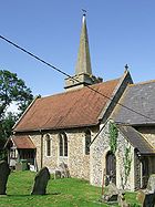
 Chedburgh
 Media related to Chedburgh at Wikimedia CommonsCategories:

