- Chur
-
For other uses, see Chur (disambiguation).
Chur 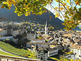
Country Switzerland 
Canton Graubünden District Plessur 46°51′N 9°32′E / 46.85°N 9.533°ECoordinates: 46°51′N 9°32′E / 46.85°N 9.533°E Population 33,377 (Dec 2009)[1] - Density 1,192 /km2 (3,086 /sq mi) Area 28.01 km2 (10.81 sq mi) Elevation 593 m (1,946 ft) - Highest 1885 m - Fürhörnli - Lowest 554 m - Bettlerküche Postal code 7000-7007 SFOS number 3901 Mayor (list) Christian Boner (as of 2008) SVP/UDC Localities Altstadt, Sand, Kasernenquartier, Industriegebiet, Loestrasse-Lürlibad, Masans, Rheinquartier Surrounded by Churwalden, Domat/Ems, Felsberg, Haldenstein, Maladers, Malix, Trimmis Twin towns Bad Homburg (Germany), Cabourg (France), Mayrhofen (Austria), Mondorf-les-Bains (Luxembourg), Olathe (USA), Terracina (Italy) Website www.chur.ch
SFSO statistics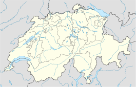
 Chur
ChurView map of Chur Chur or Coire (German pronunciation: [ˈkuː·ɐ] – in general and in Graubünden –, [ˈxuːʁ] – in other places of Switzerland –; Alemannic German: Khûr; Romansh: Cuira [ˈkwe·rɐ] or [ˈkwoi̯ ·rɐ]; Italian: Coira [ˈkɔːi̯·ɾa]; French: Coire [ˈkwa̠ːʁᵊ]; Latin: CVRIA, CVRIA RHÆTORVM and CVRIA RÆTORVM) is the capital of the Swiss canton of Graubünden and lies in the northern part of the canton.
Contents
History
 Chur in 1642, by Matthäus Merian.
The name "chur" derives perhaps from the Celtic kora or koria, meaning "tribe", or from the Latin curia.
Archaeological evidence of settlement at the site goes back as far as the Pfyn culture[2] (3900-3500 BC),[3] making Chur one of the oldest settlements in Switzerland. Remains and objects from the Bronze and Iron Ages have been found also in the eastern sector of the current city's centre. In Roman times it was a fortified camp, called Curia Raetorum; it has been suggested that under emperor Diocletian (late 3rd century AD) Chur was the capital of the province of Raetia.[4]
In the 4th century Chur became the seat of the first Christian bishopric north to the Alps. Despite a legend assigning its foundation to an alleged Briton king, St. Lucius, the first known bishop is one Asinio[5] in 451 AD. After the invasion of the Ostrogoths, it was rechristened Theodoricopolis; in the 6th century it was conquered by the Franks.[6] The city suffered several invasions, by the Magyars in 925-926, when the cathedral was destroyed, and by the Saracens (940 and 954), but afterwards it flourished thanks to its location, where the roads from several major Alpine transit routes come together and continue down the Rhine river. The routes had been already used under the Romans but acquired greater importance under the Ottonian dynasty of the Holy Roman Empire. Emperor Otto I appointed his vassal Hartpert as bishop of Chur in 958, giving the bishopric numerous privileges. In 1170 the bishop became a prince-bishop and kept total control over the road between Chur and Chiavenna.
In the 13th century the town had some 1,300 inhabitants, and was surrounded by a line of walls. In 1367 the foundation of the Three Leagues in the area was a first step towards Chur's autonomy: a burgmeister (mayor) is first mentioned in 1413, and the bishop's residence was attacked by the inhabitants in 1418 and 1422, when a series of concessions were wrung out of him. Chur was the chief town of the Gotteshausbund or Chadé (League of the House of God), and one of the places the Leagues' assemblies met regularly. As the power of the bishops, now increasingly under the influence of the nearby Habsburg County of Tyrol, decreased, in 1464 the citizens wrote a constitution which was adopted as the rule for the local guilds and political positions. In 1489 Chur obtained the right to have a tribunal of its own, but never had the title of Free Imperial City. Chur adhered to the Reformation in the 16th century, and the Catholic bishopric had to leave the city in 1524. In the same century the German language started to prevail over Romansh. Despite two fires in 1464 and 1574, the city developed economically until the Thirty Years' War, when it was destroyed and struck by plagues.
During the period of the Republic of the Three Leagues in Graubünden (ca. 1400-1797), Chur was the chief town of the Gotteshausbund or Chadé (League of the House of God), and one of the places the Leagues' assemblies met regularly. The guild constitution of the city of Chur lasted until 1839, while in 1874 the Burgergemeinde was replaced by an Einwohnergemeinde. When Graubünden became a canton in 1803, Chur was chosen as its capital.
Geography
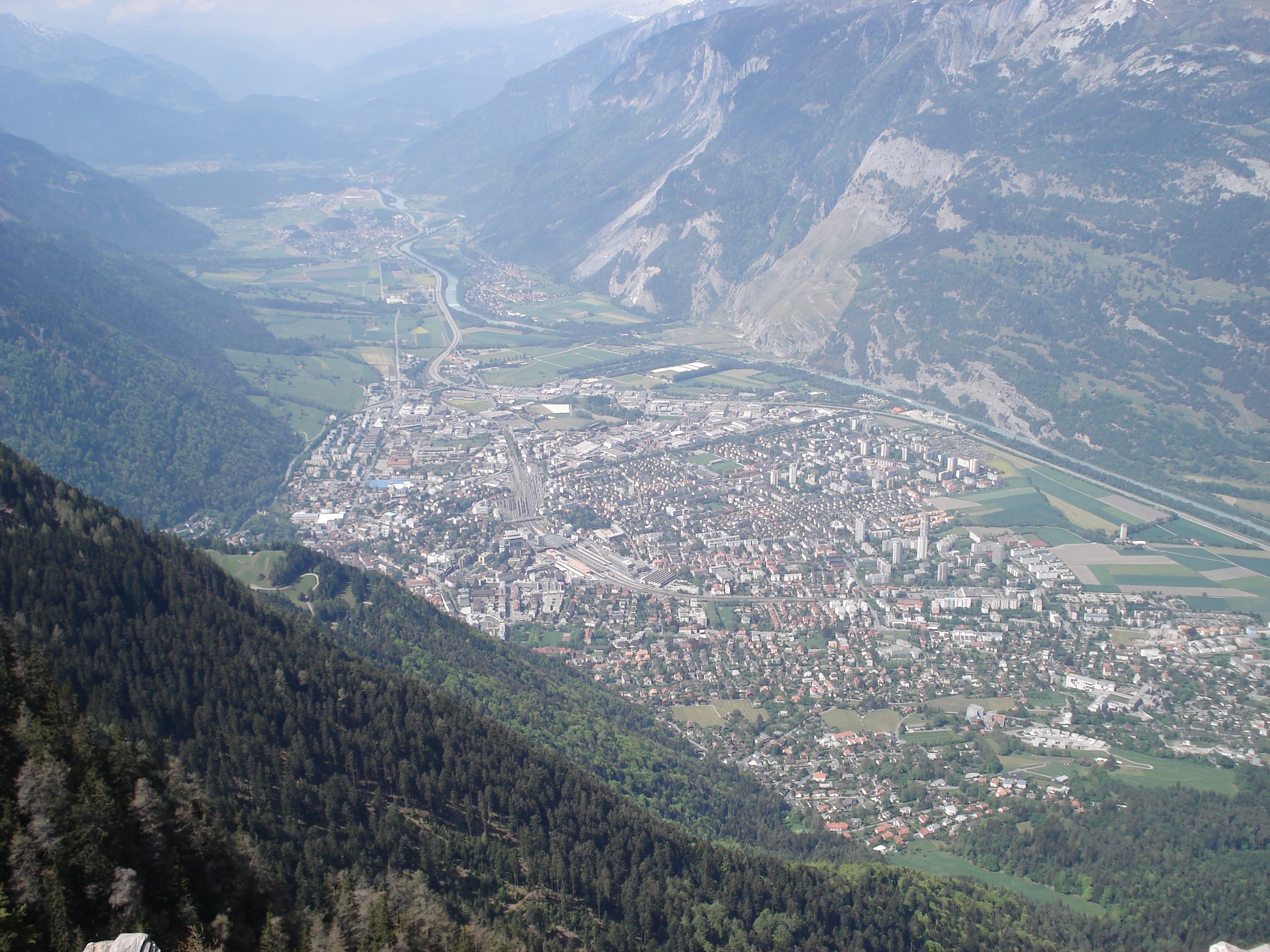
Further information: Rhine Valley Chur from its highest point, called Fürhörnli
Chur has an area, as of 2006[update], of 28 square kilometers (11 sq mi). Of this area, 18.8% is used for agricultural purposes, while 52% is forested. Of the rest of the land, 25.1% is settled (buildings or roads) and the remainder (4.1%) is non-productive (rivers, glaciers or mountains).[7]
Chur is built, at a height of 1,949 ft (594 m) above the sea-level, on the right bank of the Plessur torrent, just as it issues from the Schanfigg valley, and about a mile above its junction with the Rhine, almost entirely surrounded by the Alps, overshadowed by the Mittenberg (east) and Pizokel (south), hills that guard the entrance to the deep-cut Schanfigg valley.
It has a variable altitude in the city area from just 600 meters (2,000 ft) above sea level to 1,800 meters (5,900 ft) above sea level, while the Churer Hausberg Brambrüesch (accessible from the Old Town) is situated at 2,174 meters (7,133 ft) above sea level.
The water of Chur's spring is exported and sold as Passugger mineral water.
Main sights
 Poststrasse, Old town
 Bündner Kunstmuseum (Art Museum).
 Church of St. Martin.
 Altes Gebäude (Old Building), now home of Cantonal court.
The modern part of the city is to the west, but the old portion, with all the historical buildings, is to the east. Here is the cathedral church of St Luzius (who is the patron saint of Coire, and is supposed to be a 2nd-century British king Lucius, though in reality the name probably arose from a confusion between Lucius of Cyrene, miswritten curiensis, with the Roman general Lucius Munatius Plancus, who conquered Raetia).
 St. Maria Himmelfahrt (cathedral of the Assumption).
Built between 1178 and 1282, on the site of an older church, it contains many curious medieval antiquities (especially in the sacristy), as well as a picture by Angelica Kauffmann, and the tomb of the great Grisons political leader (d. 1637) Jenatsch. Opposite is the Bishop's Palace, and not far off, is the Episcopal Seminary (built on the ruins of a 6th-century monastic foundation). Not far from these ancient monuments is the new Raetian Museum, which contains an extensive collection of objects relating to Raetia (including the geological collections of the Benedictine monk of Disentis Abbey, Placidus a Spescha (1752–1833), who explored the high snowy regions around the sources of the Rhine). One of the hospitals was founded by the famous Capuchin philanthropist, Theodosius Florentini (1808–1865), who was for a long time the Romanist cur of Coire, and whose remains were in 1906 transferred from the cathedral here to Ingenbohl (near Schwyz), his chief foundation. The Romano-Gothic cathedral, where lie the remains of Jörg Jenatsch, was begun by Bishop Tello (758-73), and has a highly interesting crypt; it contains some remarkable paintings by Dürer and Holbein.
Chur is home to many buildings or other sites that are listed as Swiss heritage sites of national significance. There are two archeological sites in Chur, the old city which is a medieval city and Welschdörfli a prehistoric settlement and Roman Vicus. There are four archives or libraries; the bishop's palace (library and archive), the Cantonal Library, the Cantonal Archive of Graubünden and the city archive of Chur. There are also four museums on the list; the Bündner Kunstmuseum (Art Museum), Bündner Naturmuseum (Natural History Museum), the Dommuseum and the Rätisches Museum in the Haus Buol. Three churches are included in the list; The cathedral of the Assumption, the Catholic Church of St. Luzi and the Reformed church of St. Martin. There are 15 other buildings that are also heritage sites; these include the Alte Kaserne at Zeughaus 3 (the Old Armory), the Confederation Paper Mill, the Main Post Office, the new Town Hall, headquarters of the Rhätischen Bahn and several old patrician houses.[8]
The town is home to the Giger Bar designed by the Swiss artist H. R. Giger, the Old Town, the art gallery, and the natural history museum.
Demographics
Chur has a population (as of 31 December 2009) of 33,377.[1] As of 2008[update], 17.8% of the population was made up of foreign nationals.[9] Over the last 10 years the population has grown at a rate of 7.6%. Most of the population (as of 2000[update]) speaks German (81.0%), with Romansh being second most common (5.4%) and Italian being third (5.1%).[7]
As of 2000[update], the gender distribution of the population was 47.9% male and 52.1% female.[10] The age distribution, as of 2000[update], in Chur is; 3,087 children or 9.4% of the population are between 0 to 9 years old. 1,602 teenagers or 4.9% are 10 to 14, and 2,194 teenagers or 6.7% are 15 to 19. Of the adult population, 4,770 people or 14.5% of the population are between 20 to 29 years old. 5,517 people or 16.7% are 30 to 39, 4,616 people or 14.0% are 40 to 49, and 4,254 people or 12.9% are 50 to 59. The senior population distribution is 3,090 people or 9.4% of the population are between 60 to 69 years old, 2,314 people or 7.0% are 70 to 79, there are 1,307 people or 4.0% who are 80 to 89, there are 233 people or 0.7% who are 90 to 99, and 5 people or 0.0% who are 100 or more.[9]
In the 2007 federal election the most popular party was the SP which received 34% of the vote. The next three most popular parties were the SVP (31.8%), the CVP (16.4%) and the FDP (16.3%).[7]
The entire Swiss population is generally well educated. In Chur about 70.3% of the population (between age 25-64) have completed either non-mandatory upper secondary education or additional higher education (either University or a Fachhochschule).[7]
Chur has an unemployment rate of 1.8%. As of 2005[update], there were 152 people employed in the primary economic sector and about 33 businesses involved in this sector. 3,838 people are employed in the secondary sector and there are 305 businesses in this sector. 21,087 people are employed in the tertiary sector, with 1,957 businesses in this sector.[7]
From the 2000 census[update], 14,713 or 44.6% are Roman Catholic, while 12,199 or 37.0% belonged to the Swiss Reformed Church. Of the rest of the population, there are 15 individuals (or about 0.05% of the population) who belong to the Christian Catholic faith, there are 589 individuals (or about 1.79% of the population) who belong to the Orthodox Church, and there are 532 individuals (or about 1.61% of the population) who belong to another Christian church. There are 13 individuals (or about 0.04% of the population) who are Jewish, and 917 (or about 2.78% of the population) who are Muslim. There are 424 individuals (or about 1.29% of the population) who belong to another church (not listed on the census), 1,998 (or about 6.06% of the population) belong to no church, are agnostic or atheist, and 1,589 individuals (or about 4.82% of the population) did not answer the question.[9]
Historic population
The historical population is given in the following table:[11]
Year Population Swiss % German speaking % Italian speaking % Romansh speaking % Protestant % Roman Catholic 13th century 1,000-1,500 End of 15th century ca. 1,500 1780 2,331 1860 6,990 6,373 60.8% 39.1% 1880a 8,753 7,866 86.6% 3.2% 11.3% 73.6% 27.8% 1888 9,259 8,094 84.2% 2.7% 12.5% 70.4% 29.5% 1900 11,532 9,687 80.5% 5.9% 12.7% 65.6% 34.4% 1910 14,639 12,042 79.4% 8.0% 11.6% 62.8% 36.8% 1930 15,574 13,685 83.0% 5.3% 10.8% 62.8% 36.7% 1950 19,382 17,852 83.2% 5.2% 10.2% 60.4% 38.5% 1970 31,193 26,332 75.6% 9.7% 10.6% 49.1% 49.6% 1990 32,868 27,259 78.2% 6.2% 6.9% 42.7% 48.5% 2000 32,989 27,061 81.0% 5.1% 5.4% 38.5% 44.6% 2010 36,690 29,695 33.3% 42.0% - ^a Language adds up to over 100% due to counting all languages, not just first language.
Weather
Chur has an average of 105.7 days of rain per year and on average receives 814 mm (32.0 in) of precipitation. The wettest month is August during which time Chur receives an average of 103 mm (4.1 in) of precipitation. During this month there is precipitation for an average of 11.6 days. The driest month of the year is March with an average of 47 mm (1.9 in) of precipitation over 8.2 days.[12]
Climate data for Chur Month Jan Feb Mar Apr May Jun Jul Aug Sep Oct Nov Dec Year Average high °C (°F) 4.1
(39.4)6.3
(43.3)10.3
(50.5)14
(57)18.6
(65.5)21.5
(70.7)23.5
(74.3)22.7
(72.9)19.9
(67.8)15.5
(59.9)8.8
(47.8)4.1
(39.4)14.1 Daily mean °C (°F) −0.5
(31.1)1.3
(34.3)4.8
(40.6)8.3
(46.9)12.7
(54.9)15.6
(60.1)17.7
(63.9)16.9
(62.4)14.2
(57.6)9.7
(49.5)3.9
(39.0)−0.1
(31.8)8.7 Average low °C (°F) −3.9
(25.0)−2.4
(27.7)0.4
(32.7)3.4
(38.1)7.2
(45.0)10.2
(50.4)12.1
(53.8)11.8
(53.2)9.3
(48.7)5.3
(41.5)0.3
(32.5)−3.3
(26.1)4.2 Precipitation mm (inches) 52
(2.05)51
(2.01)47
(1.85)51
(2.01)75
(2.95)91
(3.58)96
(3.78)103
(4.06)77
(3.03)51
(2.01)65
(2.56)58
(2.28)814
(32.05)Avg. precipitation days 7.9 7 8.2 8.5 10.7 11.2 10.4 11.6 8.3 6.2 7.5 8.2 105.7 Source: MeteoSchweiz[12] Transportation
 Railway and PostBus station
 An Arosabahn train waits at Chur Stadt halt
Chur is 120 km by rail from Zurich, and is the meeting-point of the routes from Italy over many alpine passes (Lukmanier Pass, Splugen Pass, and San Bernardino Pass), as well as from the Engadine (Albula Pass, Julier Pass), so that it is the centre of an active trade (particularly in wine from the Valtelline), though it also has a few local factories.
The city's main railway station has the SBB-CFF-FFS lines link with the RhB (Rhaetian Railway) lines. While the SBB lines serve most of Switzerland, most of Graubünden's rail traffic is served by Rhaetian state railways. One of the lines (to Arosa) uses on-street running through streets in the centre of Chur and Sand in order to reach the station - see Chur stadtbahn.
There are three other railway stations in Chur:
- Chur Stadt (on the Chur-Arosa line)
- Chur West
- Chur Wiesental
There is also a bus station situated above the railway station.
Chur is linked by a motorway—the A13.
Twin towns
See also
- Bishop of Chur
- Mario Frick - Liechtensteiner football player, born in Chur.
- H. R. Giger - Artist born in Chur.
- Carl Hilty - philosopher and lawyer born in Chur
- Angelica Kauffmann - Artist born in Chur
- Nino Niederreiter - Canadian junior hockey player drafted 5th overall by the New York Islanders
- Johanna Spyri
- List of mayors of Chur
References
- ^ a b Swiss Federal Statistical Office, MS Excel document – Bilanz der ständigen Wohnbevölkerung nach Kantonen, Bezirken und Gemeinden (German) accessed 25 August 2010
- ^ Pre-Roman History in German, French and Italian in the online Historical Dictionary of Switzerland.
- ^ Schibler, J. 2006. The economy and environment of the 4th and 3rd millennia BC in the northern Alpine foreland based on studies of animal bones. Environmental Archaeology 11(1): 49-65
- ^ Raetia, Page at Switzerland's Historical Dictionary (Italian)
- ^ Religious life in the Alps, Switzerland Historial Dictionary (Italian)
- ^ Franks, page at Switzerland Historical Ditionary
- ^ a b c d e Swiss Federal Statistical Office accessed 27-Oct-2009
- ^ Swiss inventory of cultural property of national and regional significance 21.11.2008 version, (German) accessed 27-Oct-2009
- ^ a b c Graubunden Population Statistics (German) accessed 21 September 2009
- ^ Graubunden in Numbers (German) accessed 21 September 2009
- ^ Chur in German, French and Italian in the online Historical Dictionary of Switzerland.
- ^ a b "Temperature and Percipitation Average Values-Table, 1961-1990" (in German, French, Italian). Federal Office of Meteorology and Climatology - MeteoSwiss. http://www.meteoswiss.admin.ch/web/de/klima/klima_schweiz/tabellen.html. Retrieved 8 May 2009., the weather station elevation is 556 meters above sea level.
Sources
- Chur (municipality) in Romansh, German, French and Italian in the online Historical Dictionary of Switzerland.
 This article incorporates text from a publication now in the public domain: Chisholm, Hugh, ed (1911). Encyclopædia Britannica (11th ed.). Cambridge University Press. as Coire
- A. Eichhorn, Episcopatus Curiensis (St Blasien, 1797)
- W. von Juvalt, Forschungen fiber die Feudalzeit im Curischen Raetien, 2 parts (Zurich, 1871)
- C. Kind, Die Reformation in den Bistumern Chur und Como (Coire, 1858)
- Conradin von Moor, Geschichte von Curraetien (2 vols., Coire, 1870–1874)
- P. C. you Planta, Des alte Raetien (Berlin, 1872); Idem, Die Curraetischen Herrschaften in der Feudalzeit (Bern, 188i); Idem, Verfassungsgeschichte der Stadt Cur im Mittelalter (Coire, 1879); Idem, Geschichte von Graubünden (Bern, 1892).
- This article incorporates text from a publication now in the public domain: Herbermann, Charles, ed (1913). Catholic Encyclopedia. Robert Appleton Company.
- Principality of Liechtenstein homepage on religion
External links
- City of Chur - official website (German)
- Chur tourism office (German)
- Chur on Graubünden Holidays, Switzerland; official Graubünden tourism office - English
Arosa | Calfreisen | Castiel | Chur | Churwalden | Langwies | Lüen | Maladers | Molinis | Peist | St. Peter-Pagig | Tschiertschen-Praden
Canton of Graubünden | Districts of Canton Graubünden | Municipalities of the canton of Graubünden

Capitals of Swiss cantons Categories:- Municipalities of Graubünden
- Municipalities of Switzerland
- Chur
- Cities in Switzerland
- Cantonal capitals of Switzerland
- On-street running
- Cultural property of national significance in the canton of Graubünden
- Populated places on the Rhine


Wikimedia Foundation. 2010.