- Onchan (parish)
-
Coordinates: 54°10′26″N 4°26′20″W / 54.174°N 4.439°W
Parish of Onchan 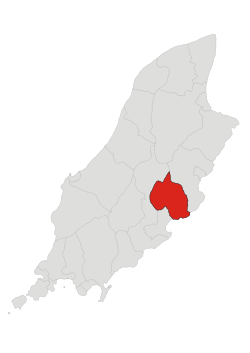
Details Population: 8803 Sheading: Garff Parish Church: St Peter's Main Peaks Height Slieau Ree 316 m Main Glens Molly Quirk's Glen Groudle Glen Bibaloe Walk Port Jack Glen Treens Slekby Alia-Begod Begod Byballo Hawstrake Horaldre Tremsare Tremott Douglas Onchan (pronounced onk-an), is a parish (Manx: Connaghyn – Kirk Conchan) in the Isle of Man. It is also a House of Keys constituency, electing three MHKs. It is in the sheading of Garff, but was formerly in the sheading of Middle.
Contents
Parish
The village of Onchan (formerly known as Kirk Conchan, as it was dedicated to St. Conchan) is situated on a headland to the north of Douglas (of which it is a suburb), and has good views over Douglas Bay. The parish stretches from Windy Corner on the TT course in the north to Port Groudle and the town of Douglas in the south; it is bounded to the west by the River Glass and the East Baldwin Valley, to the east by the parish of Lonan and to the south by the Irish Sea. The main settlement in the parish is the village of Onchan which has the second largest population on the island.
The coastline comprises the northern part of Douglas Bay and the Banks' Howe headland (which is 120 metres (390 ft) high). The highest peak in the parish is Cairn Gerjoil, near Windy Corner, at 445 metres (1,460 ft).
The parish is agricultural in nature and has only one centre of population, Onchan village. Apart from the hilly region in the north west, it is a fertile and well-cultivated district and also contains, along the hillside nearest Douglas, country villas. Onchan also is home to several large reservoirs that form part of the water supply to Douglas and the surrounding villages.
The parish has three national glens - Molly Quirk's Glen, Groudle Glen and Bibaloe Walk, which end at Groudle Beach, where there is holiday accommodation. The Groudle Glen Railway line runs along the coast line from Lhen Coan to the Headland and then on to the terminus at Sea Lion Rocks where passengers can alight and see the remains of the Victorian zoo which until World War II used to house sea lions and polar bears.
As with the other parishes on the island, Onchan can be subdivided into Treens (areas of land bounded by natural formations such as rivers). Onchan contains, according to the 1511 Manorial Roll, the following treens:
- Slekby
- Alia-Begod
- Begod (now Bygoad)
- Byballo (now Bibaloe)
- Hawstrake (now Howstrake)
- Horaldre
- Tremsare
- Tremott
- Douglas
Onchan wetlands
The Onchan Wetlands Manx: Curragh Kiondroghad is a 1-acre (4,000 m2) reserve in Onchan village that contains a variety of habitats. The site was donated to the Manx Wildlife Trust in 1988 and is open to the public for viewing and has a boardwalk which is suitable for wheelchair users.
The site contains curragh (wetlands - willow scrub), broadleaved trees, dub (pond), neutral grassland and embankments of tall grassland. This variety of habitats leads to a diversity of wildlife and plant life. Some of the plants/trees that grow there are silver birch, ash, holly, rowan, marsh marigold, yellow flag, reed canary grass, hemlock water-dropwort, woody nightshade and cuckoo flower. Also, among the wide variety of birds that on the site are the grey wagtail, goldcrest, woodcock, chiffchaff and hen harrier along with invertebrates and bats. There are also many frogs and spawn in early summer.
MHKs and elections
Year Election Turnout Candidates Elected Notes 1986 General Election
67.2%
- Peter Karran (Lab) (1075 votes)
- Richard Leventhorpe (916 votes)
- Don Maddrell (766 votes)
- FE Griffin (508 votes)
- RA Payne (477 votes)
- FD Crompton (87 votes)
- Peter Karran (Lab)
- Richard Leventhorpe
- Don Maddrell
1988 By Election
48.7%
- Ron Cretney (1436 votes)
- Lieutenant Colonel Dr Edgar Mann (748 votes)
- PKS Leventhorpe (421 votes)
- David Quirk (188 votes)
1991 General Election
66.9%
- Peter Karran (Lab) (1195 votes)
- Richard Corkill (999 votes)
- George Waft (707 votes)
- Richard Leventhorpe (548 votes)
- RA Payne (241 votes)
- FE Griffin(214 votes)
- KE Ewart (108 votes)
- David Quirk (88 votes)
Ron Cretney retired from politics and Richard Leventhorpe was defeated by George Waft and future Chief Minister Richard Corkill. 1994 By Election
44.7%
- Ray Kniveton (1283 votes)
- Richard Leventhorpe (939 votes)
- David Quirk (590 votes)
Called following the elevation to the LegCo of George Waft MLC.
1996 General Election
57.8%
- Peter Karran (Lab) (2257 votes)
- Richard Corkill (1713 votes)
- Ray Kniveton (1702 votes)
- Richard Leventhorpe (1372 votes)
- David Quirk (1143 votes)
- Ellis Killey (775 votes)
- Mark Kermode (559 votes)
The three sitting MHK's all held their seats. 1998 By Election
?
Called following the elevation to the LegCo of Ray Kniveton.
2001 General Election
57%
- Peter Karran (Lab) (2305 votes)
- Richard Corkill (2243 votes)
- Adrian Earnshaw (1929 votes)
- Geoff Cannell (1624 votes)
- David Quirk (1551 votes)
- Elizabeth Kelly (447 votes)
- Peter Karran (Lab) (2305 votes)
- Richard Corkill (2243 votes)
- Adrian Earnshaw (1929 votes)
Labour's Peter Karran and Chief Minister Richard Corkill both held their seats with increased votes, while challenger Adrian Earnshaw defeated sitting MHK Geoff Cannell to take the parish's third seat. 2006 General Election
60.8%
- Peter Karran (LVP) (2600 votes)
- Adrian Earnshaw (2078 votes)
- David Quirk (1565 votes)
- Brian Stowell (1373 votes)
- Steve Babb (1047 votes)
- Andrew Dossor (601 votes)
- Peter Karran (LVP)
- Adrian Earnshaw
- David Quirk
Former Chief Minister Richard Corkill did not stand allowing David Quirk to take Onchan's third seat. 2011 General Election
57.5%
- Peter Karran (LVP) (2074 votes)
- Zac Hall (LVP) (1812 votes)
- David Quirk (1594 votes)
- Adrian Earnshaw (1543 votes)
- June Kelly (1339 votes)
- Brian Stowell (1093 votes)
- Peter Karran (LVP)
- Zac Hall (LVP)
- David Quirk
Liberal Vannin challanger Zac Hall defeated sitting MHK Adrian Earnshaw References
External links
- Manxnotebook - Onchan
- Isle of Man Building Control Districts
- Glenology - Manx Glens study website
- Curragh Kiondroghad, Manx Wildlife Trust
- Constituency maps and general election results
Towns 
Villages Andreas | Ballabeg | Ballasalla | Ballaugh | Barregarrow | Braaid | Colby | Cregneash | Crosby | Dalby | Derbyhaven | Foxdale | Glen Maye | Glen Vine | Laxey | Niarbyl | Newtown | Onchan | Port Soderick | Port St Mary | Port Erin | Ronague | St John's | Strang | Sulby | Union MillsSheadings Parishes Categories:- Parishes of the Isle of Man
- Constituencies of the Isle of Man

Wikimedia Foundation. 2010.