- Diamond Shoal Light
-
Diamond Shoal Light 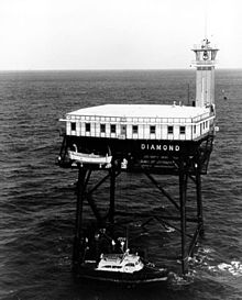
Undated photograph of Diamond Shoal Light (USCG) Coordinates 35°9′12″N 75°17′48″W / 35.15333°N 75.29667°WCoordinates: 35°9′12″N 75°17′48″W / 35.15333°N 75.29667°W[1] Year first lit 1966 Automated 1977 Deactivated 2001 Foundation Four black piles Construction prefabricated modules Tower shape White square platform with tower at one corner Height 120 ft Admiralty number J2400 ARLHS number USA-230 USCG number 2-0640 Diamond Shoal Light was an off-shore lighthouse marking Diamond Shoals off Cape Hatteras.
History
Diamond Shoals, which extend many miles out from Cape Hatteras, is considered to be one of the most dangerous spots on the Atlantic seaboard. While a light was exhibited from the cape itself from 1804, its range was insufficient, and a lightship was stationed on the shoal itself in 1824. It was driven off station numerous times, eventually being wrecked near Ocracoke Inlet in 1827. Various buoys were placed beginning in 1852, but all were short-lived.
In 1889 congress authorized construction of a permanent lighthouse on the shoal, at a cost not to exceed $500,000. The firm of Anderson & Barr, which had constructed the Fourteen Foot Bank Light in Delaware Bay in 1885-1887, was awarded the contract. A caisson was constructed in Norfolk, Virginia and towed to the site in June 1891. It was sunk into the shoal on July 1 and immediately began to tilt due to the sandy bottom and severe scour by the currents. Addition of iron plates at the top of the structure merely succeeded in keeping it marginally above water. A storm on July 4 drove the work crews away and destroyed the structure. Anderson, who supervised the construction, later claimed that the problem was exacerbated by out of date charts with inaccurate soundings. In any case, construction was abandoned, and $79,000 of the original appropriation was diverted to the construction of a lightship to replace the failed tower.
 WLV 189, the last lightship stationed at Diamond Shoals (USCG 1962)
That lightship, LV 69, was the first of six lightships employed at Diamond Shoals in the twentieth century. Prior to World War I, lightships were assigned in pairs at this station, which each relieving the other; after LV 71 was sunk by the German submarine U-104, a single ship was assigned, relieved as needed. During World War II the lightship was replaced by a lighted buoy. The last lightship stationed here, WLV 189, was the first lightship built after the Coast Guard took over the Lighthouse Service, and the first all-welded lightship; it was expressly built for service at this station, and remained in service there until 1966.
In the early 1960s, "Texas Tower" lighthouses were erected at six offshore sites on the East coast. Diamond Shoals was the second to last to be built, and was activated in 1966; it was automated in 1977. The unmanned lighthouse suffered significant damage from Hurricane Fran in 1996, and the catwalks were subsequently found to be so rotten that the light could only be safely visited by helicopter. The light was extinguished in 2001, and has since been removed.
Although the light was removed, the tower still stands and is frequented by fishermen for the many species of fish that live below and near it. Amberjack and barracuda are some of the larger fish that call Diamond Shoals light tower their home.
References
- ^ "National Data Buoy Center: Station DSLN7". Data Buoy Detail. NOAA, US National Data Buoy Center. http://www.ndbc.noaa.gov/station_page.php?station=DSLN7. Retrieved 2009-03-13.
- "Historic Light Station Information and Photography: North Carolina". United States Coast Guard Historian's Office. http://www.uscg.mil/history/weblighthouses/LHNC.asp. Retrieved 2008-10-08.
- Putnam, George Rockwell (1917). Lighthouses and Lightships of the United States. Boston & New York: Houghton Mifflin. p. 96. http://books.google.com/?id=UNM3AAAAMAAJ&pg=PA94&lpg=PA94&dq=Diamond+Shoal+lighthouse. Retrieved 2008-10-08.
- Roberts, Bruce and Shelton-Roberts, Cheryl (May 2000). Attempt to Build a Lighthouse on Diamond Shoals. Lighthouse Digest. http://www.lighthousedepot.com/lite_digest.asp?action=get_article&sk=0744&bhcd2=1222302541. Retrieved 2008-10-08.
- Stick, David & Stick, Frank (1990). The Outer Banks of North Carolina, 1584-1958. Chapel Hill, NC: UNC Press. p. 292. ISBN 080784277X. http://books.google.com/?id=ndHZR_BFlDEC&pg=PA292&lpg=PA292&dq=Diamond+Shoal+lighthouse. Retrieved 2008-10-08.
- "The Cape Hatteras Lightstation". National Park Service. http://www.nps.gov/archive/caha/capelight.htm. Retrieved 2008-10-08.
- "U.S. Lightship Station Assignments". United States Coast Guard. http://www.uscg.mil/history/weblightships/Lightship_Station_Index.asp. Retrieved 2008-10-08.
- Zepke, Terrance (1998). Lighthouses of the Carolinas: A Short History and Guide. Sarasota, FL: Pineapple Press Inc. p. 37. ISBN 1561641480. http://books.google.com/?id=XQfwXBwe-G4C&pg=PA35&lpg=PA35&dq=Diamond+Shoal+lighthouse. Retrieved 2008-10-08.
Lighthouses of North Carolina Active: Bodie Island Light • Cape Hatteras Light • Cape Lookout Light • Currituck Beach Light • Oak Island Light • Ocracoke Light
Deactivated/Dismantled: Bald Head Light • Cape Fear Light • Diamond Shoal Light • Federal Point Light • Frying Pan Shoals Light • Hatteras Beacon • Price Creek Light • Roanoke Marshes Light • Roanoke River Light • Wade Point Light Categories:
- Lighthouses in North Carolina
- Buildings and structures completed in 1966


Wikimedia Foundation. 2010.