- Citadelle Laferrière
-
National History Park - Citadel, Sans Souci, Ramiers * UNESCO World Heritage Site
Country Haiti Type Cultural Criteria iv, vi Reference 180 Region ** Latin America and the Caribbean Inscription history Inscription 1982 (6th Session) * Name as inscribed on World Heritage List
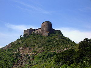
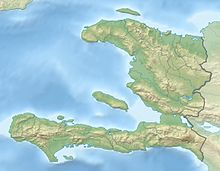
** Region as classified by UNESCOThe Citadelle Laferrière or, Citadelle Henry Christophe, or simply the Citadelle (in English, spelled Citadel), is a large mountaintop fortress in northern Haiti, approximately 17 miles (27 km) south of the city of Cap-Haïtien and five miles (8 km) uphill from the town of Milot. It is the largest fortress in the Americas and was designated by the United Nations Educational, Scientific and Cultural Organization (UNESCO) as a World Heritage Site in 1982—along with the nearby Sans-Souci Palace. The mountaintop fortress has itself become an icon of Haiti. The Citadel was built by Henri Christophe, a key leader during the Haitian slave rebellion, after Haiti gained independence from France at the beginning of the 19th century.[1]
The massive stone structure was built by up to 20,000 workers between 1805 and 1820 as part of a system of fortifications designed to keep the newly-independent nation of Haiti safe from French incursions. The Citadel was built several miles inland, and atop the 3,000 ft (910 m) Bonnet a L’Eveque mountain, to deter attacks and to provide a lookout into the nearby valleys. Cap-Haïtien and the adjoining Atlantic Ocean are visible from the roof of the fortress. Anecdotally, it is possible to sight the eastern coast of Cuba, some 90 miles (140 km) to the west, on clear days.
The Haitians outfitted the fortress with 365 cannons of varying size. Enormous stockpiles of cannonballs still sit in pyramidal stacks at the base of the fortress walls. Since its construction, the fortress has withstood numerous earthquakes, though a French attack never came.
Henri Christophe initially commissioned the fortress in 1805. At the time, Christophe was a general in the Haitian army and chief administrator of the country's northern regions. In 1806, along with co-conspirator Alexandre Pétion, Christophe launched a coup against Haiti's emperor, Jean-Jacques Dessalines. Dessalines's death led to a power struggle between Christophe and Pétion, which ended with Haiti divided into northern and southern states, with the north under Christophe's presidency by 1807. He declared himself king in 1811.
The Citadel was part of a system of fortifications that included Fort Jacques and Fort Alexandre, built on the mountains overlooking Port-au-Prince. Dessalines ordered those forts built in 1805 to protect the new nation against French attacks.
In the event of an invasion, Christophe planned to have his military burn the valuable crops and food stocks along the coast, then retreat to the fortress, setting ambushes along the sole mountain path leading to the Citadel.
Christophe suffered a stroke in 1820, and some of his troops mutinied. Shortly afterwards, he committed suicide, according to legend, by shooting himself with a silver bullet. Loyal followers covered his body in quicklime and entombed it in one of the Citadel's interior courtyards to prevent others from mutilating the corpse.
The colossal physical dimensions of the fortress have made it into a Haitian national symbol, featured on tourist ministry posters as well as currency and stamps. The walls of the fortress itself rise up 130 feet (40 m) from the mountaintop, and the entire complex, including cannonball stocks, yet excluding the surrounding grounds, covers an area of 108,000 square feet (10,000 m2). The large foundation stones of the fortress were laid directly into the stone of the mountaintop and fastened with a mortar mixture that included quicklime, molasses, and the blood of local cows and goats.
Large cisterns and storehouses in the fortress's interior were designed to store enough food and water for 5,000 defenders for up to one year. The fortress included palace quarters for the king and his family, in the event that they needed to take refuge within its walls. Other facilities included dungeons, bathing quarters, and bakery ovens. The Citadel's appearance from the trail leading up to its base has been likened to the prow of a great stone ship, jutting out from the mountainside. The structure is angular, and assumes different geometric forms based on the viewer's orientation. Though most of the fortress has no roof as such (the interior top is a latticework of stone walkways), some slanted portions are adorned with bright red tiles. The fortress has been repaired and refurbished several times since its construction, including in the 1980s with help from UNESCO and the World Monuments Fund, though little of it has been replaced, and its design remains the same.
The Citadel is one of the most popular tourist destinations in Haiti. Directions to and history of the fortress are provided by self-appointed guides from the town of Milot. Visitors may be asked to pay a small fee at the entrance to the Citadel. Visitors are encouraged to rent a horse for the uphill trek. The first portion of the seven-mile (11 km) trail is navigable by 4WD vehicle, although infrequent landslides and construction projects sometimes make this unreliable. From the mid-level parking lot, the second portion must be completed either on horseback or on foot. The entire seven-mile-trail starting in Milot, almost completely uphill, can be walked by experienced hikers who carry plenty of water. Most of the interior of the Citadel fortress itself is accessible to visitors, who may also climb the numerous staircases to the fortress's roof, which is free of guardrails. On a clear day, the city of Cap-Haïtien and the Atlantic Ocean can be seen to the north.
Though the turbulent political situation in Haiti (principally in the central region) has deterred visitors in recent years, the regions of the north and south of the country remain largely peaceful, making travel to the Citadel less challenging or hazardous than travel within the Haitian capital, Port-au-Prince.
Footnotes
- ^ "National History Park – Citadel, Sans Souci, Ramiers". UNESCO World Heritage. 1982. http://whc.unesco.org/en/list/180. Retrieved 2007-08-16.
External links
Coordinates: 19°34′25″N 72°14′38″W / 19.57361°N 72.24389°W
Categories:- Forts in Haiti
- Military history of Haiti
- World Heritage Sites in Haiti
- Nord Department
Wikimedia Foundation. 2010.


