- Vancouver, Washington
-
City of Vancouver[1] — City — A View of Downtown Vancouver from Jantzen Beach (Hayden Island).

Flag
SealNickname(s): "The Couve"[2][3][4] Motto: A colorful past, a bright future Location in Washington
Coordinates: 45°38′1″N 122°36′10″W / 45.63361°N 122.60278°WCoordinates: 45°38′1″N 122°36′10″W / 45.63361°N 122.60278°W country United States State Washington County Clark Founded 1825 Incorporated 1857 Government – Mayor Tim Leavitt Area – City 46.1 sq mi (119.5 km2) – Land 42.8 sq mi (110.8 km2) – Water 3.3 sq mi (8.7 km2) Elevation 171 ft (52 m) Population (2010) – City 161,791 – Density 3,659/sq mi (1,413.8/km2) – Metro 2,241,841 (Portland-Vancouver, Gresham, etc.) ofm.wa.gov Time zone Pacific (UTC−8) – Summer (DST) PDT (UTC−7) Area code(s) 360 FIPS code 53-74060[5] GNIS feature ID 1531916[6] Website www.cityofvancouver.us Vancouver is a city on the north bank of the Columbia River in the U.S. state of Washington. Incorporated in 1857, it is the fourth largest city in the state with a 2010 census population of 161,791 as of April 1, 2010.[7] Vancouver is the county seat of Clark County and forms part of the Portland-Vancouver metropolitan area, the 23rd-largest metropolitan area in the United States.
Vancouver shares its name with the larger city of Vancouver located 305 miles (491 km) north in the Canadian province of British Columbia. Both cities were named in honor of sea captain George Vancouver, although the Canadian city was incorporated 29 years after the incorporation of Vancouver, Washington, and more than 60 years after the name Vancouver was first used in reference to the historic Fort Vancouver trading post on the Columbia River. City officials have periodically suggested changing the US city's name to Fort Vancouver, Vancouver USA, or even Old Vancouver to reduce confusion with its northern neighbor. Many Pacific Northwest residents distinguish between the two cities by referring to the Canadian city as "Vancouver, B.C." and the United States one as "Vancouver, Washington," or "Vancouver USA." Local nicknames include: "Vantucky"[8][9][10][11][12][13] and "The 'Couv(e)".[14]
Contents
History
 The Marshall House in Officers Row, built in 1886 and later named after George C. Marshall
The Vancouver, Washington, area was inhabited by a variety of Native American tribes, most recently the Chinook and Klickitat nations, with permanent settlements of timber longhouses.[15] The Chinookan and Klickitat names for the area were reportedly Skit-so-to-ho and Ala-si-kas, respectively, meaning "land of the mud-turtles."[16] First European contact was in 1775, with approximately half of the indigenous population dead from small pox before the Lewis and Clark expedition camped in the area in 1806.[15] Within another fifty years, other actions and diseases such as measles, malaria and influenza had reduced the Chinookan population from an estimated 80,000 "to a few dozen refugees, landless, slaveless and swindled out of a treaty."[15]
Meriwether Lewis wrote that the Vancouver area was "the only desired situation for settlement west of the Rocky Mountains." The first permanent European settlement did not occur until 1824, when Fort Vancouver was established as a fur trading post of the Hudson's Bay Company. From that time on, the area was settled by both the US and Britain under a "joint occupation" agreement. Joint occupation led to the Oregon boundary dispute and ended on June 15, 1846, with the signing of the Oregon Treaty, which gave the United States full control of the area. Before 1845, American Henry Williamson laid out a large claim west of the Hudson's Bay Company (including part of the present-day Port of Vancouver), called Vancouver City and properly registered his claim at the U.S. courthouse in Oregon City, before leaving for California.[17] The City of Vancouver was incorporated on January 23, 1857.[18]
Based on an act in the 1859–60 legislature, Vancouver was briefly the capital of the Washington Territory, before being returned to Olympia, Washington by a 2–1 ruling of the territory's supreme court, in accordance with Isaac Stevens' preference and concern that proximity to Oregon might give its southern neighbor undue influence.[19][20][21]
U.S. Army Captain (and future President) Ulysses S. Grant was quartermaster at what was then known as Columbia Barracks for 15 months beginning in September 1852. Soon after leaving Vancouver, he resigned from the army and did not serve again until the outbreak of the American Civil War. Other notable generals to have served in Vancouver include George B. McClellan, Philip Sheridan, Oliver O. Howard and 1953 Nobel Peace Prize recipient George Marshall.[22]
 City of Vancouver as shown in 1888 map from Clarke County Auditor, Washington Territory.
Army presence in Vancouver was very strong, as the Department of the Columbia built and moved to Vancouver Barracks, the military reservation for which stretched from the river to what is currently Fourth Plain Boulevard and was the largest Army base in the region until surpassed by Fort Lewis, 120 miles (190 km) to the north. Built on the old company gardens and skirmish range, Pearson Army Field (later Pearson Field) was a key facility, and at one point the US Army Signal Corps operated the largest spruce cut-up plant in the world to provide much-needed wood for airplanes. Vancouver became the end point for two ultra-long flights from Moscow, USSR over the North Pole. The first of these flights was performed by Valery Chkalov in 1937 on a Tupolev ANT-25RD airplane. Chkalov was originally scheduled to land at an airstrip in nearby Portland, Oregon, but redirected at the last minute to Vancouver's Pearson Airfield. Today there is a street named for him in Vancouver. In 1975 an obelisk was erected at Pearson Field commemorating this event.
Separated from Oregon until 1917, when the Interstate Bridge began to replace ferries, Vancouver had three shipyards just downstream which produced ships for World War I before World War II brought an enormous economic boom. An Alcoa aluminum plant opened on September 2, 1940, using inexpensive power from the nearby New Deal hydropower turbines at Bonneville Dam. After the bombing of Pearl Harbor, Henry Kaiser opened a shipyard next to the U.S. Army reserve, which by 1944 employed as many as 36,000 people in a twenty-four hours a day, seven days a week production of liberty ships, LST's, and "baby flat tops." This influx of shipyard workers boosted the population from 18,000 to over 80,000 in just a few months, leading to the creation of the Vancouver Housing Authority and six new residential developments: Fruit Valley, Fourth Plain Village, Bagley Downs, Ogden Meadows, Burton Homes and McLoughlin Heights. Each of these was later incorporated into the city, and are well-known neighborhoods, while the neighboring "shipyard city" of Vanport, Oregon, would be destroyed by the Memorial Day flood of 1948.
In 1956, Willie Nelson moved to Vancouver to begin his musical career, recording "Lumberjack." The single sold fairly well, but it did not establish his career. Nelson continued to work as a radio announcer in Vancouver and sing in clubs. He sold a song called "Family Bible" for $50; the song was a hit for Claude Gray in 1960, has been covered widely and is often considered a gospel music classic.
Vancouver has recently experienced conflicts with other Clark County communities because of rapid growth in the area. The city's first annexation more than doubled its size in 1909, with the largest annexation of 1997 adding 11,258 acres (45.56 km2) and 58,171 residents.[23] As a result of urban growth and the 1997 annexation, Vancouver is often thought of as split between two areas, East and West Vancouver, divided by NE Andresen Road. West Vancouver is home to downtown Vancouver and some of the more historical parts of the city, as well as recent high-density mixed-use development.
More than one-third of the Vancouver urban area's population lives in unincorporated urban area north of the city limits, including the communities of Hazel Dell, Felida, Orchards and Salmon Creek. If county leaders had approved a major annexation plan in 2006, Vancouver would have passed Tacoma and Spokane to become the state's second-largest city.[24]
Downtown revitalization
In 1997 the city of Vancouver decided to dedicate the next 15–20 years to redevelop and revitalize a huge portion of the downtown core. The first projects started in the early 2000s with the construction of many tall condominium structures around Esther Short park and in the Uptown Village neighborhood. The most lauded outside investment was the construction of a Hilton hotel directly across from the park. Currently the city is building a new shopping complex, including a recently finished Fred Meyer, just outside of the downtown core.
The Columbian newspaper finished building a new seven-story building adjacent to the Hilton in 2008 which due to financial strains in the company remained vacant and unused. Early in 2010, The Columbian filed for Chapter 11 bankruptcy and the building defaulted to Bank of America. In statement issued June 3, 2010 by City Manager Pat McDonnell, the City of Vancouver has reached a tentative agreement to purchase the former downtown Columbian office building for a fraction of the construction cost. Under the terms of the pending deal, the city will buy the two-year-old building and 5.14 acres (20,800 m2) for $18.5 million for use as a new city hall. Before giving up the building in bankruptcy, the owners of The Columbian office building had been asking $41.5 million. By making the move, the city will save $1 million annually it pays on leases to house about 300 employees in about five buildings around the city, McDonnell said in his announcement.[25]
There are plans in the future for a new development along C Street in downtown that would include a new library, a new Marriott hotel and roughly 250 new condominiums. Other planned projects include:
- Library Square – Mixed use project which includes a condominiums building, hotel/condominiums building, offices building, and a new main library.
- The Luxe – 6 story offices and condominiums building.
- Waterfront Redevelopment – Which include 10K Residents Envision, Retails, Offices, Parks, and more.
- Prestige Plaza – 6 story building which includes condominiums and offices.
- Columbia river crossing – project in which a new 10-lane bridge and transit will be built along Interstate 5 from Jantzen Beach area to downtown Vancouver
Geography and climate
Vancouver is located at 45°38′1″ North, 122°36′11″ West (45.633743, −122.603011)[26] just north of the Columbia River, just west of where the Columbia River Gorge bisects the volcanic Cascade Range and just east of where the Willamette River enters the Columbia. The city of Vancouver[27] is in the Western Lowlands region of Washington.[28] When clouds do not blanket the Puget-Willamette trough formed by the Cascade and Coast Range, Mount Hood, Mount Saint Helens, and Mount Adams are all visible from Vancouver.
According to the United States Census Bureau, the city has a total area of 46.1 square miles (119 km2), of which 7.14% water.
Vancouver lies just north of Portland, Oregon and shares a similar climate. Both are classified as dry-summer subtropical (Csb) on the Köppen climate classification, with certain key exceptions. High pressures east of the Cascade Range create something of a venturi effect, leading to cold east winds down the Columbia River Gorge. Unsheltered by the Willamette Valley, Vancouver has historically seen colder temperatures, including "silver thaw" storms where freezing rain cakes limbs and power lines. Such storms can paralyze Vancouver. They frequently froze the river, and in 1916 cut electric power in the city for almost two weeks. Rainfall occurs frequently throughout the fall, winter, and spring, but ceases around the middle of June, with dry and warm weather lasting through September. Average annual precipitation is 42 inches (1,100 mm). Heavy snowfalls are infrequent and snow often falls and doesn't stick, with major snowstorms only occurring every 2–4 years. Close proximity to the river was also a concern for flooding, before dams constricted the river, destroying features such as Celilo Falls. Periodic floods have been a nuisance, with two of the most destructive in June 1894 and May, 1948. The 1948 Memorial Day flood almost topped the Interstate Bridge's support piers and completely destroyed nearby Vanport, Oregon. Other unusual storms include the Columbus Day windstorm of 1962 and an April 5, 1972 tornado which rated F3 on the Fujita scale, striking a local school. A F1 tornado struck on January 10, 2008 just after noon causing moderate damage along a 2-mile (3.2 km) path from Vancouver Lake to the unincorporated Hazel Dell area.
Because of its proximity to Portland, many people who live in Vancouver work in Portland. In 2003, 70% of workers in Vancouver worked in Clark County. Those who live in Clark County and work in Oregon have to pay Oregon's relatively high income tax. (Washington State does not have such a tax.) Additionally, they may choose to shop in Portland to take advantage of a wider variety of shopping choices, and the fact that Oregon has no sales tax. However, there is a risk in such avoidance because Washington does have a use tax that is due on all purchases made in Oregon that are then returned to Washington. Vancouver residents "shop at their own risk" when attempting to avoid the sales tax in Washington, although the rule is rarely, if ever, enforced (except for purchases requiring registration, such as motor vehicles).
Because many Vancouver residents work in Portland, there is typically significant rush hour traffic congestion on two bridges that cross the Columbia River — the Interstate Bridge and the Glenn Jackson Bridge. In 2006 there were 278,043 weekday vehicle crossings on the two bridges.[29]
Climate data for Vancouver, Washington Month Jan Feb Mar Apr May Jun Jul Aug Sep Oct Nov Dec Year Record high °F (°C) 65
(18)73
(23)83
(28)90
(32)99
(37)105
(41)106
(41)103
(39)103
(39)90
(32)72
(22)65
(18)106
(41)Average high °F (°C) 45
(7)50
(10)55
(13)60
(16)66
(19)71
(22)79
(26)78
(26)74
(23)63
(17)52
(11)46
(8)62 Average low °F (°C) 32
(0)34
(1)37
(3)40
(4)46
(8)50
(10)54
(12)53
(12)48
(9)41
(5)38
(3)33
(1)42 Record low °F (°C) −8
(−22)−3
(−19)18
(−8)23
(−5)28
(−2)34
(1)37
(3)35
(2)28
(−2)19
(−7)6
(−14)−10
(−23)−10
(−23)Precipitation inches (mm) 5.8
(147)4.9
(124)4.2
(107)3.1
(79)2.6
(66)1.7
(43)0.8
(20)1.1
(28)1.8
(46)3.3
(84)6.3
(160)6.4
(163)42.0
(1,067)[citation needed] Demographics
Historical populations Census Pop. %± 1880 1,722 — 1890 3,545 105.9% 1900 3,126 −11.8% 1910 9,300 197.5% 1920 12,637 35.9% 1930 15,766 24.8% 1940 18,788 19.2% 1950 41,664 121.8% 1960 32,464 −22.1% 1970 42,493 30.9% 1980 42,834 0.8% 1990 46,380 8.3% 2000 143,560 209.5% 2010 161,791 12.7% As of the census[5] of 2008, there were 164,000 people in Vancouver alone but an estimated 2,250,000 people in the Portland-Vancouver Metro area. As of the 2000 census there were 56,628 households, and 36,298 families living in the city. The population density is 3,354.7 people per square mile (1,295.4/km²). There were 60,039 housing units at an average density of 1,403.0 per square mile (541.7/km²). The racial makeup of the city was 84.81% White, 2.50% African American, 0.97% Native American, 4.51% Asian, 0.54% Pacific Islander, 2.86% from other races, and 3.80% from two or more races. Hispanic or Latino of any race were 6.29% of the population. 16.4% were of German, 9.2% English, 8.4% Irish and 7.9% American ancestry according to Census 2000. 89.2% spoke English, 5.1% Spanish, 3.2% Russian, 1.4% Ukrainian and 1.1% Vietnamese as their first language. A large increase in persons with Russian or Ukrainian as their primary language has occurred.
There were 56,628 households out of which 33.4% had children under the age of 18 living with them, 47.3% were married couples living together, 12.1% had a female householder with no husband present, and 35.9% were non-families. 27.6% of all households were made up of individuals and 8.3% had someone living alone who was 65 years of age or older. The average household size was 2.50 and the average family size was 3.06.
In the city the population was spread out, with 26.7% under the age of 18, 9.8% from 18 to 24, 32.1% from 25 to 44, 20.6% from 45 to 64, and 10.7% who were 65 years of age or older. The median age was 33 years. For every 100 females there were 96.9 males. For every 100 females age 18 and over, there were 93.8 males.
The median income for a household in the city was $41,618, and the median income for a family was $47,696. Males had a median income of $37,306 versus $26,940 for females. The per capita income for the city was $20,192. 9.4% of families and 12.2% of the population were below the poverty line, including 16.1% of those under the age of 18 and 8.2% of those 65 and older.
Economy
 The banner of the Uptown Village neighborhood
 Token coins used in Vancouver during the mid-20th century, including a state sales tax token and one used to pay toll on the Interstate Bridge
The economy of Vancouver has paralleled that of the region generally. Moving from a salmon- and trade-based indigenous economy by the Chinook people, the Hudson's Bay Company pioneered extractive industries such as the fur trade and timber. Subsistence agricultural gave way to market and export crops such as apples, strawberries and prunes. Largely bypassed by the railroad in the 1880s, when the Oregon Steam Navigation company would ferry trains across the river downstream from St. Helens, Oregon to Kalama, Washington, early downtown development was focused around Washington Street (where ferries arrived), lumber and Vancouver Barracks activities such as a large spruce mill for manufacturing airplanes. A 1908 railroad swing bridge across the Columbia allowed greater industrial developments such as the Standifer Shipyard during the first world war. With the Interstate Bridge and Bonneville Dam Vancouver saw an industrial boom in the 1940s, including the Kaiser shipyard and Alcoa, as well as a Boise Cascade paper mill, just west of the Interstate Bridge.[30]
As the old-growth forests were depleted and heavy industry left the United States, Vancouver's economy has largely changed to high tech and service industry jobs, with many residents commuting to Portland. Vancouver contains the corporate headquarters for Nautilus, Inc. and The Holland (parent company of the Burgerville, USA restaurant chain).[31]
Downtown is home to a variety of independently owned small businesses, while outer areas are dominated by strip malls and franchise stores.
Vancouver is increasingly popular with retirees, partially because of its proximity to Portland and the absence of a state income tax in Washington.
Largest Employers
According to the City's 2009 Comprehensive Annual Financial Report,[32] the largest employers in the city are:
# Employer # of Employees 1 Vancouver Public Schools 3,358 2 Evergreen Public Schools 3,076 3 Southwest Washington Medical Center 2,556 4 County of Clark 1,925 5 Hewlett-Packard 1,800 6 Fred Meyer 1,543 7 SEH America 1,190 8 City of Vancouver 1,097 9 Wells Fargo 840 10 Kaiser Permanente 785 Education
Public schools
Vancouver has two school districts: Vancouver Public Schools and Evergreen School District.
The Vancouver Public Schools cover most of west Vancouver and has six high schools: Hudson's Bay High School, Columbia River High School, Fort Vancouver High School, Lewis and Clark High School, Skyview High School, and the Vancouver School of Arts and Academics (grades 6–12). It also has six middle schools: Alki Middle School, Discovery Middle School, Gaiser Middle School, Jason Lee Middle School, Thomas Jefferson Middle School, and McLoughlin Middle School.
Vancouver Public School's elementary schools include Sarah J. Anderson, Chinook, Eisenhower, Felida, Ben Franklin, Fruit Valley Community Learning Center, Harney, Hazel Dell, Hough, Martin Luther King, Lake Shore, Lincoln, Marshall, Minnehaha, Peter S. Ogden, Eleanor Roosevelt, Sacajawea, Salmon Creek, Truman, Walnut Grove, and Washington.
The Evergreen School District covers most of east Vancouver and has six high schools: Evergreen High School, Mountain View High School, Heritage High School, Union High School, Legacy High School, and the Clark County Skills Center.
The district also consists of six middle schools: Covington Middle School, Cascade Middle School, Frontier Middle School, Pacific Middle School, Wy'East Middle School, and Shahala Middle School.
Evergreen School District's elementary schools include Burton, Hearthwood, Ellsworth, Image, Orchards, Sunset, Silver Star, Sifton, Pioneer, Burnt Bridge Creek (BBC), York, Crestline, Riverview, Marrion, Fisher's Landing, Mill Plain, Columbia Valley, Harmony, Illahee, and Endeavour.
Vancouver is also home to the Washington School for the Deaf and Washington State School for the Blind, and Home Choice Academy, a school for home-schoolers.
Colleges and universities
- Clark College (two year)
- Washington State University, Vancouver
Architecture and notable buildings
 Smith Tower built in 1965.
Mother Joseph was one of the first architects in the region, and because of its relatively long history, Vancouver contains a variety of buildings. Homes vary from Victorians and craftsman bungalows downtown, to small wartime tract housing and ranch-styles mid-town, with rural styles and larger homes in the outer ring. In addition to the reconstructed Fort Vancouver at the Fort Vancouver National Historic Site, the city was named one of the National Register of Historic Places' "Dozen Distinctive Destinations" for 2003.[33]
Other notable buildings in Vancouver include:
- The Covington House at 4201 Main Street, a log cabin and boarding school built 1846-1848.
- Officers Row, including The Grant House (first house on the Columbia Barracks) and the Queen Anne-style 1866 Marshall House
- Mother Joseph's Providence Academy, constructed in 1868, where Evergreen Boulevard crosses Interstate 5
- St. James Catholic Church (originally St. James Cathedral), saw its first Roman Catholic mass celebrated August 16, 1885
- The Carnegie Library at Sixteenth and Main, which opened on New Year's Eve, 1909, to showcase its unusual electric lights
- The 1914 Chicago-style U.S. National Bank (now the Heritage Building) at sixth and Main
- The 1916 U.S. Post Office at 1211 Daniels Street
- The vertical-lift Interstate Bridge, which opened on February 14, 1917, Oregon's 58th anniversary
- The 1935 art deco telephone exchange building at Eleventh and Washington
- The 1941 Clark County courthouse, designed by prolific local architect Day Hillborn
- Smith Tower, a round downtown apartment building for the elderly, built in 1965
- The Hilton Hotel and Vancouver Convention Center across from Esther Short park
Many of these buildings have been re-purposed. The 1867 Slocum House, an Italianate villa style residence originally built one block south of its current location in Esther Short Park. It was moved to its present location at Esther Short Park in 1966 and now houses a community theatre company.[34] The Carnegie Library was expanded in the 1940s, becoming the Clark County Historical Museum after a new library was built in 1963. Other buildings have been torn down for urban renewal or renovated to house professional offices such as lawyers and accountants.
Art and Culture
Vancouver has recently[when?] seen a revitalization of local art and cultural events. In 2010 there was a movement among local artists to form cooperatives and meet with established local gallery owners for a monthly forum known as "Art Conversations". Much of Vancouver's art scene is located in Downtown Vancouver.[citation needed]
Film and TheatreThe Kiggins Theatre located within the Downtown Vancouver Art District, was built in 1936 by architect Day Hillborn and still is in use as a classic independent theatre, it was named for J.P. Kiggins, an entrepreneur and politician who cut a swath through town in the early 20th century, serving as Vancouver's mayor for 15 non-consecutive years between 1908 and 1935.
Public libraries
Annual events
Since the mid-1960s, Vancouver hosted a Fourth of July fireworks display on the grounds of Fort Vancouver National Historic Site that drew many people to the city. The display routinely ran to 45 minutes, attracted up to 60,000 visitors and was broadcast on area television, one of the largest west of the Mississippi River. Due to the death of key organizer "Mister Fireworks" Jim Larson and a poor economy, the show was not held in 2009.[35] A shorter, redesigned 2010 show charged admission and brought in approximately 35,000 people.[36]
Late August features the Vancouver Wine and Jazz Festival in Esther Short Park, the largest jazz festival in SW Washington.
Each September sees St. Joseph Catholic School host the Vancouver Sausage Fest, drawing attendance upwards of 100,000 over three days.
Local media
Vancouver is located within the Portland media market for print, radio, and television media. It does however serve as the hometown for some media.
- The Columbian
- The Independent - A student-operated newspaper of Clark College published weekly during the Fall, Winter and Spring terms of the academic year.
- The Oregonian (based in Portland, Oregon; this paper also covers some southwest Washington news)
- The VanCougar - Weekly newspaper of Washington State University Vancouver
- The Vancouver Business Journal covers local business news [2]
- The Vancouver Voice was southwest Washington's only alternative periodical, published from 2006-2011.
Radio stations in the Portland, Oregon metropolitan area market By FM frequency By AM frequency NOAA Weather Radio frequency 162.525 · 162.550By callsign K220IN · K228EU · K240CZ · K242AF · K272EL · K274AR · K283BL · K296FT · KBFF · KBMS · KBNP · KBOO · KBPS · KBVM · KDZR · KEX¹ · KFBW · KFIS · KFXX · KGDD · KGON · KIG98 · KINK · KKCW · KKOV · KKPZ · KKRZ · KKSN · KLVP · KLTH · KMHD · KNRK · KOOR · KOPB-FM · KPAM · KPDQ · KPDQ-FM · KPFR · KPOJ · KPWX · KQAC · KRRC · KRSK · KRYN · KRYP · KUFO · KUIK · KUPL-FM · KWBY · KWIP · KWJJ-FM · KXET · KXJM · KXL-FM · KXPD · KXTG · KYCH-FM · KZME · KZRI · KZZR · WNG604 · WPHG710²Historic KISN · KQIVFuture move-in Oregon Radio Markets: Bend • Eugene-Springfield • Medford-Ashland • Portland
See also: List of radio stations in OregonWashington Radio Markets: Seattle-Tacoma • Spokane • Richland-Kennewick-Pasco • Vancouver, WA/Portland, OR • Wenatchee • Yakima
Other Washington Radio Regions: Northwest Washington • Lewiston, ID • Pullman-Moscow
See also: List of radio stations in Washington¹ = Clear-channel stations with extended nighttime coverage.² = Traveller Information Service transmitter for Portland International Airport♦ = fully or partial simulcasting stationsTelevision in Portland/Salem, Oregon and Vancouver, Washington Metro Portland KATU (2.1 ABC, 2.2 This TV) • KRCW-LP 5 (The CW) • KOIN (6.1 CBS) • KGW (8.1 NBC, 8.2 KGW 24/7, 8.3 Estrella TV) • KOPB-TV (PBS/OPB, 10.1 HD, 10.2 "Plus", 10.3 FM) • KPTV (12.1 Fox) • KNMT (24.1 TBN, 24.2 TCC, 24.3 JCTV, 24.4 Enlace, 24.5 Smile) • K26GJ-D (26.1 religious) • KOXI-LD (28.1 A1) • KORK-LD (41.1 HSN) • KKEI-CA (34.1 TEL) • KEVE-LD (36.1 3ABN) • KPXG-LD (42.1 ION, 42.2 Qubo, 42.3 ION Life) • KOXO-LD (44.1 TFR) • KGWZ-LD (46.1 Weather map) • KUNP-LP 47 (UNI) • KPDX (49.1 MNTV)
Metro Salem KOAC (PBS/OPB, 7.1 HD, 7.2 "Plus", 7.3 FM) • KORS-CD (16.1 HSN, 16.2 A1) • KWVT-LP (17.2 A1, 27.2 RTV, 37.2 AZA) • K21GX 21 (religious) • KPXG (22.1 ION, 22.2 Qubo, 22.3 ION Life) • KSLM-LD (27.1 RTV, 17.1 A1, 37.1 AZA) • KRCW-TV (32.1 The CW, 32.2 Antenna TV, 32.3 Universal Sports) • K50GG 50 (MNTV)
La Grande The Dalles Cable-only CSN Northwest • CVTV (Vancouver, WA) • Root Sports Northwest • Northwest Cable News • The Oregon Channel • TVW (Olympia, WA)
Defunct See also Seattle, Eugene, Bend, Yakima/Tri-Cities and Boise TVTransportation
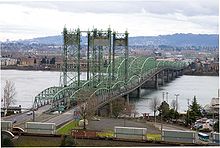 Interstate Bridge looking south and showing BNSF Railway that parallels Washington State Route 14 east through the Columbia River Gorge.
Vancouver has two interstate freeways, I-5 and I-205, both of which run north–south, across the Columbia River into Portland and toward Seattle. It also has two heavily travelled state highways within the city limits. SR 14 begins at I-5 in downtown Vancouver and makes its way east. It is a freeway all the way until Camas. SR 500 begins from I-5 at 39th Street in north Vancouver, travels east connecting with I-205, and continues east into the suburb of Orchards where the freeway terminates at Fourth Plain Boulevard, and meets with the south end of north-south-oriented 117th Ave., SR 503. A third state highway, SR 501, starts at I-5 and heads west through downtown and continues along a path that runs between the Columbia River and Vancouver Lake. Route 501 – SR501 dead ends a few miles north of Vancouver.
The Port of Vancouver USA operates a port on the Columbia River, which separates Oregon to the south and Washington to the north. It handles over 400 ocean-going vessels annually, as well as a number of barges which ply the river and its tributaries as far as Lewiston, Idaho.
The area's mass transit system is C-TRAN, the Clark County Public Transportation Benefit Area Authority, which operates 135 buses, vanpools, and paratransit vehicles. There are also a number of express routes into Portland's downtown.
In 1995, Clark County voters defeated a ballot measure that would have funded extension of Portland's MAX Light Rail system north into Vancouver.[37] Opposition to paying for light rail was strong at that time, but slowly declined over the following several years, eventually leading Vancouver officials to begin discussing the idea again.[38][39] Meanwhile, TriMet reconstituted its planned MAX line to Vancouver as a shorter line running only within Portland, which potentially could later be extended across the river and into Clark County. This extension of the MAX system opened in 2004 as the Yellow Line,[40] running as far north as the Portland Expo Center, approximately 1 mile (2 km) south of downtown Vancouver.
Vancouver has always been well served by rail; current freight railroads operating in Vancouver include the BNSF, Union Pacific, and the local shortline Lewis and Clark Railway. Amtrak, the national passenger rail system, provides service to Vancouver. Three routes, the Coast Starlight, the Empire Builder, and the Amtrak Cascades serve the city.
Pearson Field, located near downtown Vancouver, is the main airport serving the city. The airport is intended primarily for general aviation without any commercial air service. The nearest commercial airport is Portland International Airport (PDX).
In 2008, Vancouver passed a citywide law requiring anyone on a wheeled device such as a bicycle, skateboard, scooter or skates to wear a helmet while on any sidewalk, street, trail or other public property. Many local cyclists opposed the law as a misuse of city funds and police efforts, as well as encroachment on personal freedoms. Despite opposition from the public, the Vancouver City Council passed the measure 5-1 with the mayor saying, "[S]tatistics be damned. I support this."[41][42]
Sister cities
Vancouver has two sister cities:
Source:[43]
See also
- People from Vancouver, Washington
- List of mayors of Vancouver, Washington
References
- ^ "City Charter – Article I Government". http://www.cityofvancouver.us/charter.asp?menuid=10462&submenuid=10479&itemID=11398.
- ^ "Vantucky". UrbanDictionary.com. http://www.urbandictionary.com/define.php?term=Vantucky.
- ^ Raftery, Isolde (September 2, 2007). "Vancouver in Tune to Past, Future.". The Columbian. http://www.accessmylibrary.com/coms2/summary_0286-32781323_ITM.
- ^ "Sten to Propose Renaming City". BlueOregon. April 2005. http://www.blueoregon.com/2005/04/sten_to_propose.html.
- ^ a b "American FactFinder". United States Census Bureau. http://factfinder.census.gov. Retrieved 2008-01-31.
- ^ "US Board on Geographic Names". United States Geological Survey. 2007-10-25. http://geonames.usgs.gov. Retrieved 2008-01-31.
- ^ "Official July 1, 2008 Population Estimates". Office of Financial Management. June 29, 2006. http://www.ofm.wa.gov/pop/april1/default.asp. Retrieved July 14, 2007.
- ^ http://web.archive.org/web/20090601093700/http://www.vanvoice.com/article/19677-vantucky-meets-tin-pan-alley
- ^ http://vanvoice.com/article?articleTitle=you+know+your+from+vantucky+if...--1287789309--453--
- ^ "Cafe offers 'Vantucky Strikes Back' T-shirts, humor along with coffee". The Oregonian. 17 May 2011. http://www.oregonlive.com/clark-county/index.ssf/2011/05/cafe_offers_vantucky_strikes_back_t-shirts_humor_along_with_coffee.html. Retrieved 5 June 2011.
- ^ "Vancouver coffee shop Strikes Back and Abides with latest Couve T-shirt promotion". The Oregonian News Network (The Oregonian). 16 May 2011. http://clarkcountyblog.com/vancouver-coffee-shop-strikes-back-and-abides-withlatest-couve-tshirt-promotion/. Retrieved 5 June 2011.
- ^ "Portland's wacky and wonderful neighboring cities.". Stumped in Stumptown. 29 March 2011. http://www.stumpedinstumptown.com/2011/03/portlands-wacky-and-wonderful-neighboring-cities/. Retrieved 5 June 2011.
- ^ Jayne, Greg (5 June 2011). "Maneuver by council makes county look like Podunkville (commentary)". The Columbian. http://www.columbian.com/news/2011/jun/05/maneuver-by-council-makes-county-look-like-podunkv/. Retrieved 5 June 2011. "Because part of the impact of bringing professional baseball to town would be in helping Vancouver to shed its image as Podunkville. As Vantucky. As a sleepy little burg that is a suburb of Portland."
- ^ http://wweek.com/editorial/3319/8709/
- ^ a b c "History of Vancouver – Early Northwest Native People". City of Vancouver. http://www.cityofvancouver.us/stage/history.asp?menuid=10466&submenuid=10537&itemID=16091. Retrieved November 18, 2007.
- ^ gesswhoto.com – Native Sons 1900
- ^ "Images of America DOWNTOWN VANCOUVER," Pat Jollota, p 42
- ^ "History of Vancouver – An Overview of Vancouver's History". City of Vancouver. http://www.cityofvancouver.us/history.asp?menuid=10466&submenuid=10537&itemID=16090. Retrieved November 18, 2007.
- ^ "Single Vote Robbed Vancouver of State Capitol". The Columbian. Archived from the original on September 27, 2007. http://web.archive.org/web/20070927174307/http://www.columbian.com/history/Vancouver/vancouvercapitol.cfm. Retrieved November 18, 2007.
- ^ "Governor Isaac Stevens selects Olympia as capital of Washington Territory on November 28, 1853.". HistoryLink.org. http://www.historylink.org/essays/output.cfm?file_id=5054. Retrieved November 18, 2007.
- ^ "Senate Resolution 8636" (PDF). Washington State Legislature. http://www.leg.wa.gov/pub/billinfo/2005-06/Pdf/Bills/Senate%20Resolutions/8636-City%20of%20Olympia.pdf. Retrieved November 18, 2007.
- ^ "About Vancouver's 150th Anniversary". City of Vancouver. http://www.cityofvancouver.us/150th.asp?. Retrieved November 18, 2007.
- ^ Annexation History, City of Vancouver website, accessed 2010-07-30.
- ^ komotv.com
- ^ Brettman, Allan. "City of Vancouver agrees to buy Columbian office building for $18.5 million | OregonLive.com." OregonLive.com. The Oregonian, 3 June 2010. Web. 24 June 2010. <http://www.oregonlive.com/business/index.ssf/2010/06/city_of_vancouver_agrees_to_bu.html
- ^ "US Gazetteer files: 2010, 2000, and 1990". United States Census Bureau. 2011-02-12. http://www.census.gov/geo/www/gazetteer/gazette.html. Retrieved 2011-04-23.
- ^ http://www.cityofvancouver.us/
- ^ http://www.access.wa.gov/
- ^ "Columbia River Bridge Crossings: Historical". Southwest Washington Regional Transportation Council. http://www.rtc.wa.gov/data/traffic/brdgawd.asp. Retrieved November 18, 2007.
- ^ Jollata, Pat (2004). Images of America: Downtown Vancouver. Arcadia Publishing. ISBN 0-7385-2959-1.
- ^ Vancouver Business Journal Book of Lists 2007, p. 24.
- ^ "City of Vancouver Comprehensive Annual Financial Report" (PDF). http://www.cityofvancouver.us/upload/images/FMS/reports/2009_COV_CAFR_2.pdf.
- ^ "Quick Facts". SW Washington Convention and Visitors Bureau. http://www.southwestwashington.com/quick_facts.asp. Retrieved November 18, 2007.
- ^ slocumhouse.com
- ^ Mize, Jeffrey (March 18, 2009). "Many mourn loss of Vancouver's Mr. Fireworks". The Columbian.
- ^ Damewood, Andrea (July 27, 2010). "Fourth at the Fort recovers costs, generates warm feelings". The Columbian. http://www.columbian.com/news/2010/jul/27/fourth-at-the-fort-recovers-costs-generates-warm-f/. Retrieved 2010-07-28.
- ^ Stewart, Bill (February 8, 1995). "Clark County turns down north-south light rail." The Oregonian, p. A1.
- ^ Church, Foster (March 26, 2001). "Vancouver mayor revives discussion of light rail." The Oregonian.
- ^ Hamilton, Don (April 19, 2002). "Cities take a second look at light rail/Anti-MAX cities reconsider views". Portland Tribune. http://www.portlandtribune.com/news/story.php?story_id=10965. Retrieved August 8, 2009.
- ^ Hamilton, Don (April 30, 2004). "Making tracks to the MAX". Portland Tribune. http://www.portlandtribune.com/news/story.php?story_id=23819. Retrieved August 8, 2009.
- ^ "Updated: Vancouver passes all-ages helmet law". [1]. February 25, 2008. http://bikeportland.org/2008/02/25/vancouver-passes-all-ages-helmet-law/.
- ^ "Vancouver city council enacts helmet law". The Columbian. February 26, 2008. http://www.columbian.com/news/localNews/2008/02/02262008_Vancouver-city-council-enacts-helmet-law.cfm.
- ^ ltgov.wa.gov
External links
- City of Vancouver Web Site, including sesquicentennial timeline
- Vancouver Chamber of Commerce Web Site
- Fort Vancouver National Historic Site
Municipalities and communities of Clark County, Washington County seat: VancouverCities Battle Ground | Camas | La Center | Ridgefield | Vancouver | Washougal | Woodland‡

Town CDPs Amboy | Barberton | Brush Prairie | Cherry Grove | Dollar Corner | Felida | Five Corners | Hazel Dell North | Hazel Dell South | Hockinson | Lake Shore | Lewisville | Meadow Glade | Mill Plain | Minnehaha | Mount Vista | Orchards | Salmon Creek | Venersborg | Walnut Grove
Unincorporated
communityFootnotes ‡ This populated place also has portions in an adjacent county or counties
Categories:- Cities in Washington (state)
- Populated places in Clark County, Washington
- Vancouver, Washington
- County seats in Washington (state)


Wikimedia Foundation. 2010.