Line Islands

Line Islands

Coordinates: 0°0′S 157°0′W / 0°N 157°W / 0; -157

Line Islands is located in Pacific Ocean
{{{alt}}}
Line Islands
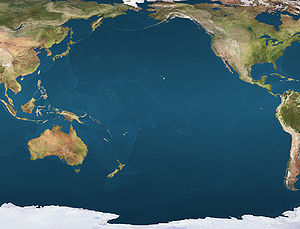
Location of the Line Islands in the Pacific Ocean
Line Islands

The Line Islands, Teraina Islands or Equatorial Islands, is a chain of eleven atolls and low coral islands in the central Pacific Ocean, south of the Hawaiian Islands, that stretches for 2,350 km in a northwest-southeast direction, making it one of the longest islands chains of the world. Eight of the islands form part of Kiribati, while the remaining three are United States territories grouped with the United States Minor Outlying Islands.

Those that are part of Kiribati are in the world's farthest forward time zone, UTC+14. The time of day is the same as in Hawaiʻi, but the date is one day ahead. The time is 26 hours ahead of some other islands in Oceania like Baker Island which have UTC-12.

The United States previously claimed all the Line Islands under the Guano Islands Act. This claim was relinquished under the Treaty of Tarawa, which recognised Kiribati's sovereignty over the majority of the chain.

The group is geographically divided into three subgroups; The Northern, Central, and Southern Line Islands. The Central Line Islands are sometimes grouped with the Southern Line Islands. The table below lists the islands from North to South.

Atoll/Island/Reef Island Area
km²
Lagoon
km²
Population Coordinates Status

Northern Line Islands (Fanning's Group)

Kingman Reef 0.03 60 0 6°24′N 162°24′W / 6.4°N 162.4°W / 6.4; -162.4 (Kingman Reef) U.S. unincorporated territory
Palmyra Atoll 6.56 15 ~4 5°52′N 162°6′W / 5.867°N 162.1°W / 5.867; -162.1 (Palmyra Atoll) U.S. incorporated territory
Teraina (Washington Island) 14.2 2* 1,155 4°43′N 160°24′W / 4.717°N 160.4°W / 4.717; -160.4 (Teraina) part of Kiribati
Tabuaeran (Fanning Island) 33.7 110 2,539 3°52′N 159°22′W / 3.867°N 159.367°W / 3.867; -159.367 (Tabuaeran) part of Kiribati
Kiritimati (Christmas Island) c.322 c.320 5,115 1°53′N 157°24′W / 1.883°N 157.4°W / 1.883; -157.4 (Kiritimati) part of Kiribati

Central Line Islands

Jarvis Island 4.45 - 0 0°22′S 160°03′W / 0.367°S 160.05°W / -0.367; -160.05 (Jarvis Island) U.S. unincorporated territory
Malden Island 39.3 13* 0 4°01′S 154°59′W / 4.017°S 154.983°W / -4.017; -154.983 (Malden Island) part of Kiribati
Filippo Reef - 1.5 0 5°30′S 151°50′W / 5.5°S 151.833°W / -5.5; -151.833 (Filippo Reef) outside EEZ
Starbuck Island 21 25 0 5°37′S 155°56′W / 5.617°S 155.933°W / -5.617; -155.933 (Starbuck Island) part of Kiribati

Southern Line Islands

Caroline Island 3.76 6.3 0 9°57′S 150°13′W / 9.95°S 150.217°W / -9.95; -150.217 (Caroline Island) part of Kiribati
Vostok Island 0.24 - 0 10°06′S 152°25′W / 10.1°S 152.417°W / -10.1; -152.417 (Vostok Island) part of Kiribati
Flint Island 3 - 0 11°26′S 151°48′W / 11.433°S 151.8°W / -11.433; -151.8 (Flint Island) part of Kiribati
Line Islands 514.74 542 8,809

* The lagoon areas marked with an asterisk are contained within the island areas of the previous column because they are, unlike in the case of a typical atoll, inland waters completely sealed off from the sea.

Map of Kiribati CIA WFB.png

Only three islands are inhabited, with a total population of 8,809 (census of 2005), of which 5,115 are on Kiritimati, 2,539 on Tabuaeran, and 1,155 on Teraina. The total population of these three atolls in 1900 was about 300.

Kiritimati is the largest atoll in the world in terms of land area. The islands were annexed by Britain in 1888 with a view to laying the Pacific cable with Tabuaeran (then Fanning Island) as a relay station. Said cable functioned between 1902 and 1963 except for a short period in 1914.

Copra and "Petfish" are the main export products (with seaweed).

See also


Wikimedia Foundation. 2010.

Игры ⚽ Поможем написать реферат

Look at other dictionaries:

  • Line Islands — Lage der Line Islands (rechts) im Pazifik Gewässer Pazifischer Ozean …   Deutsch Wikipedia

  • Line Islands — [līn] group of coral atolls of Kiribati in the central Pacific, south of Hawaii, formerly divided between the U.S. and Great Britain * * * Chain of islands, central Pacific Ocean, south of the Hawaiian Islands. The Line Islands extend 1,600 mi (2 …   Universalium

  • Line Islands —   [ laɪn aɪləndz, englisch], Inselgruppe im Pazifik, Linieninseln …   Universal-Lexikon

  • Line Islands — [līn] group of coral atolls of Kiribati in the central Pacific, south of Hawaii, formerly divided between the U.S. and Great Britain …   English World dictionary

  • Line Islands — Îles de la Ligne Pour les articles homonymes, voir Ligne. Îles de la Ligne Line Islands (en) …   Wikipédia en Français

  • Line Islands — Admin ASC 1 Code Orig. name Line Islands Country and Admin Code KI.02 KI …   World countries Adminstrative division ASC I-II

  • Line Islands — Line′ Is′lands n. pl. geg a group of 11 coral atolls in the central Pacific, S of Hawaii: eight of the islands belong to Kiribati, and three to the U.S …   From formal English to slang

  • Line Islands — geographical name islands Kiribati in W Pacific S of Hawaii; formerly divided between the United States (Kingman Reef & Palmyra) & Great Britain (Teraina, Tabuaeran, & Kiritimati) population 4782 …   New Collegiate Dictionary

  • Line Islands — /laɪn ˈaɪləndz/ (say luyn uyluhndz) plural noun a group of islands in the central Pacific of which eight form part of Kiribati, the rest being administered by the US …  

  • Line Islands — español islas de la Línea o Espóradas Ecuatoriales Cadena de islas del océano Pacífico central, al sur del archipiélago de Hawai. Las islas se extienden a lo largo de 2.600 km (1.600 mi) y tienen un territorio de 500 km2 (193 mi2). Dentro del… …   Enciclopedia Universal

Share the article and excerpts

Direct link
Do a right-click on the link above
and select “Copy Link”