- Ma'ale Hever
-
Ma'ale Hever Hebrew מַעֲלֵה חֶבֶר Name meaning Named after Hever Stream Founded 1982 Council Har Hebron Region West Bank Coordinates 31°29′10″N 35°9′58″E / 31.48611°N 35.16611°ECoordinates: 31°29′10″N 35°9′58″E / 31.48611°N 35.16611°E 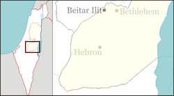
 Ma'ale Hever
Ma'ale Hever (Hebrew: מַעֲלֵה חֶבֶר) or Pnei Hever (Hebrew: פְּנֵי חֶבֶר), at an elevation of 810 metres, is a Religious Israeli settlement. The village is located in the eastern Hebron hills in the West Bank, east of Hebron and within the municipal jurisdiction of the Har Hebron Regional Council. The village, home to over fifty families, is named after the nearby Hever Stream. The international community considers Israeli settlements in the West Bank illegal under international law, but the Israeli government disputes this.[1]
Ma'ale Hever was established as Nahal Yakin on January 31, 1982 (7th of Shvat, 5742) as a pioneer Nahal military outpost and demilitarized when turned over to eleven families shortly thereafter on August 24, 1983 (15th of Elul, 5743). In its early years, the only route leading to the village passed through Bani Na'im, a city now part of the Palestinian National Authority.
The community rabbi is Rabbi Chaim Klein.
Assaf Ramon, son of Israeli Astronaut Ilan Ramon who was aboard the fatal mission Columbia when the space shuttle exploded, was killed when the F-16 he was flying crashed in the area of Pnei Hever.[2]
References
- ^ "The Geneva Convention". BBC News. 10 December 2009. http://news.bbc.co.uk/2/hi/middle_east/1682640.stm. Retrieved 27 November 2010.
- ^ http://fr.jpost.com/servlet/Satellite?cid=1251804559879&pagename=JPost/JPArticle/ShowFull
External links
Moshavim Communal settlements Adora · Abigail · Beit Hagai · Eshkolot · Livne (Shani) · Ma'ale Hever · Negohot · Otniel · Sansana · Shim'a · Susya · Telem · Teneh OmarimOutposts Categories:- Har Hebron Regional Council
- Nahal settlements
- Religious Israeli settlements
- Populated places established in 1982

Wikimedia Foundation. 2010.